It looks like you're using an Ad Blocker.
Please white-list or disable AboveTopSecret.com in your ad-blocking tool.
Thank you.
Some features of ATS will be disabled while you continue to use an ad-blocker.

Quake Watch 2012
page: 224share:
reply to post by Lil Drummerboy
No, not specifically but I can't see any reason why it should not have smelly geysers being a volcanic area.
I would say that it has a small problem in that not only is it volcanic but it straddles a major fault line and plate boundary. Does not sound like too good a combination to me!
No, not specifically but I can't see any reason why it should not have smelly geysers being a volcanic area.
I would say that it has a small problem in that not only is it volcanic but it straddles a major fault line and plate boundary. Does not sound like too good a combination to me!
Strong earthquake hits parts of western Indonesia
Another EQ hit Indonesia today. It is not a mega or super quake but it is moderate enough to damage buildings and lives.
A strong undersea earthquake has hit parts of western Indonesia, but no tsunami warning was issued and there have been no immediate reports of damage or casualties. The U.S. Geological Survey says Friday’s 6.2-magnitude quake struck at a depth of 20 kilometers (12 miles). Indonesia’s Meteorology and Geophysics Agency says it was centered about 160 kilometers (100 miles) southeast of Mentawai island, off western Sumatra.
Link
Earthquake Details
This event has been reviewed by a seismologist.
Magnitude 6.2
Date-Time Friday, September 14, 2012 at 04:51:47 UTC Friday, September 14, 2012 at 11:51:47 AM at epicenter Time of Earthquake in other Time Zones
Location 3.363°S, 100.588°E Depth 19.8 km (12.3 miles)
Region KEPULAUAN MENTAWAI REGION, INDONESIA
Distances 163 km (101 miles) SSW of Sungaipenuh, Indonesia 190 km (118 miles) WNW of Bengkulu, Indonesia 214 km (132 miles) W of Curup, Indonesia 250 km (155 miles) W of Lubuklinggau, Indonesia
Location Uncertainty horizontal +/- 11.6 km (7.2 miles); depth +/- 3 km (1.9 miles)
Parameters NST=521, Nph=564, Dmin=285 km, Rmss=0.88 sec, Gp= 22°, M-type=teleseismic moment magnitude (Mw), Version=E
Source Magnitude: USGS NEIC (WDCS-D) Location: USGS NEIC (WDCS-D)
Event ID usc000cnlk
USGS
reply to post by timetothink
I do reset it to show all small ones through large ones. I thought it very weird that nothing whatsoever had shown up for the Japan area for 24 hours, not even weak ones under 2.5 had shown.
reply to post by JustMike
What a phenomenal breakdown, thank you!
reply to post by muzzy
I hadn't heard of this, thank you!
Type: Earthquake
59 minutes ago
Magnitude: 4.5
DateTime: Friday September 14 2012, 11:53:17 UTC
Region: Northern California
Depth: 24 km
Source: CSEM-EMSC Feed
59 minutes ago
Magnitude: 4.5
DateTime: Friday September 14 2012, 11:53:17 UTC
Region: Northern California
Depth: 24 km
Source: CSEM-EMSC Feed
Type: Earthquake
73 minutes ago
Magnitude: 3.2
DateTime: Friday September 14 2012, 11:57:20 UTC
Region: Northern California
Depth: 25.4 km
Source: USGS Feed
73 minutes ago
Magnitude: 3.2
DateTime: Friday September 14 2012, 11:57:20 UTC
Region: Northern California
Depth: 25.4 km
Source: USGS Feed
reply to post by azureskys
Four more earthquakes in the same location, SW of Rio Dell, CA to add to the two posted above:
Mag 4.0 24.3 km depth
Mag 3.3 25.8 km depth
Mag 2.5 26.0 km depth
Mag 2.3 27.8 km depth
Something is readjusting...
Four more earthquakes in the same location, SW of Rio Dell, CA to add to the two posted above:
Mag 4.0 24.3 km depth
Mag 3.3 25.8 km depth
Mag 2.5 26.0 km depth
Mag 2.3 27.8 km depth
Something is readjusting...
I probably should of come here with my observations and questions. So, here is what I said in a different forum about the smell in California.
I was searching for images showing both N. America and Central America plate boundries and faults. I found this (hope I link it correctly)
Nope. But it is the first image listed on the site.
Looks like San Andreas is slipping south. Is that pushing on the Cocos plate causing magma to find a way up and out? Is the slipping in 3 areas along Ca. Causing pressure on the magma below the Salton area?
I don't think I copied and pasted that right. Please forgive me
Last night I was looking at the Ca/Nv earthquake map that covers the last 7 days. I noticed a few things. First Monday, September 10, 2012 at 08:44:42 AM there was a 3.3 at a depth of 2.1 miles. Could this quake along with low water levels and the strong storm that hit this area be why the smell was so much worse than in the past? There were a series of smaller quakes in the same area of the Salton Sea that followed the quake on Monday.
I then began going down the list at this site. I noticed a pattern where one quake or two would be down south then one or two upnorth of San Francisco. Occasionally one would be in the Yosemite area or up near Eureka. I checked the site again this morning and noticed several 3+ quakes near Eureka.
It seems to me that the plates along the west coast are getting more active. I know they are always having small quakes. I feel as though the volcanos in Central America are connected to the volcanic sulfer smell continuing to come from the Salton area. I would not be suprised if there becomes more volcanic activity from the volcanos up through California.
I was searching for images showing both N. America and Central America plate boundries and faults. I found this (hope I link it correctly)
Nope. But it is the first image listed on the site.
Looks like San Andreas is slipping south. Is that pushing on the Cocos plate causing magma to find a way up and out? Is the slipping in 3 areas along Ca. Causing pressure on the magma below the Salton area?
I don't think I copied and pasted that right. Please forgive me
edit on 14-9-2012 by Twilightgem because: what forum I was in
Originally posted by PuterMan
reply to post by SpaceJockey1
Dear SpaceJockey, why do you consider it was due?
Prov,Date/Time UTC,Latitude,Longitude,Magnitude,Depth(Km),Location
usgs,2012-09-14 04:51:47, -3.362, 100.587, 6.2, 19.8, Kepulauan Mentawai Region. Ind.
usgs,2012-09-08 10:51:43, -3.189, 135.084, 6.1, 14.1, Papua. Ind.
usgs,2012-09-03 18:23:04, -10.785, 113.880, 6.4, 8.8, South Of Java. Ind.
usgs,2012-08-18 09:41:54, -1.318, 120.102, 6.3, 10.0, Sulawesi. Ind.
usgs,2012-07-25 00:27:45, 2.707, 96.046, 6.4, 22.0, Simeulue. Ind.
usgs,2012-06-23 04:34:53, 3.011, 97.908, 6.1, 95.0, Northern Sumatra. Ind.
usgs,2012-04-21 01:16:52, -1.603, 134.274, 6.6, 16.0, Nr. N. Coast Of Papua. Ind.
usgs,2012-03-20 17:56:19, -3.830, 140.220, 6.2, 66.9, Papua. Ind.
usgs,2011-10-13 03:16:29, -9.378, 114.628, 6.1, 35.1, South Of Bali. Ind.
I think Indonesia gets more than it's fair share of the pie, in fact recently it seems a bit busier, but I am curious as to your reasoning.
Sorry, but no 'scientific' basis my friend
Only basing my comment on the activity of the recent high numbers of 5's & 6's in that region, which appear to be occurring more regularly over the last 2 months, that previous months. You can almost count on a 6+ hitting that region every week lately.
After the 2 x 8's back in early April, things went pretty quiet for the next 3-4 months, but certainly most of the major spots have fired up again, so it does seem a bit more 'predictable' to anticipate 6+'s IMHO.
BTW, my gut still tells me that we're due to have a dramatic event (could just as easily be volcanic), between now and the end of November, which will get a lot Dec 21st doomsters stirred up.
I'm reminded of that dream I had a few weeks ago, about a big quake in the Idaho / Utah region, but thank God I can't predict earthquakes!
edit on 14-9-2012 by SpaceJockey1 because: grammar
I'm with SpaceJockey!
Rainbows
Jane
Rainbows
Jane
edit on 14-9-2012 by angelchemuel because: keyboard
I also can't help but think something big is happening and not just locally here in CA but in General. I've never seen the USGS map lit up
constantly like a switchboard. You would have to be dead not to notice what has been going on in the last month. We are seeing earthquakes in places
that don't normally have them or very little and those places that are active are becoming more so.
Tell me I'm not going crazy but it's just so hard NOT to notice that something is on the move. I'm seeing more frequent quakes along the Pacific rise and Mid Atlantic ridges. One plate move and other must accomodate but wow, things seem like they are in hyper drive right now.
I live in LA so I know all about the sulfer smell this week and I live just 20 miles south of the San Andreas (Palmdale) Segment. I've just had my family in Costa Rica ride out that big EQ last week and now more family in Guatemala figuring out what to do about the Volcano. They are Costa Rican so they can always go back to CR but then things there seem very unsettled.
I'm not a believer in the whole Mayan 2012 deal and I'm even part Mayan! I do however think that something is happening on a larger scale to the planet right now and it's hard not to notice.
This is up your alley and I didn't see it posted. A glitch?
6.1 M earthquake in Canada captured From chuggkole (September 14, 2012)
6.1 M earthquake in Canada captured From chuggkole (September 14, 2012)
2 rare quakes off the West Coast of the north part of the North Island, NZ
Both Minor in magnitude, but interesting locations, the first one started out as a Mag 5 on the new SeisComP3 automated Geonet system.
Not sure what Aotea Knoll is about, extinct volcano?
www.geonet.org.nz...
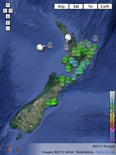
interactive version here
pretty busy day, 49 quakes UTC 14th Sept.
Not a lot happening down Fiordland area lately,
poor coverage by the new system?, or overdue for a 5+?
Ref: 2012p695984
Status: automatic
Lat/Long: -37.46577 172.14609
When: 2012-09-14T12:19:53.778Z UTC
Depth: 3.8 km
Mag: 3.69 ML
Number of Stations:
Location: Aotea Knoll
FEGL Region: Off W. Coast Of N. Island. N.Z.
Felt: yes
Energy Released: 5.169 tonnes of TNT
Ref: 2012p695164
Status: automatic
Lat/Long: -37.72695 174.52814
When: 2012-09-14T05:03:06.346Z UTC
Depth: 124.8 km
Mag: 3.56 ML
Number of Stations:
Location: West of Raglan
FEGL Region: Raglan Hbr.-Tauranga-Whakatane
Felt: no
Energy Released: 3.299 tonnes of TNT
Both Minor in magnitude, but interesting locations, the first one started out as a Mag 5 on the new SeisComP3 automated Geonet system.
Not sure what Aotea Knoll is about, extinct volcano?
www.geonet.org.nz...
interactive version here
pretty busy day, 49 quakes UTC 14th Sept.
Not a lot happening down Fiordland area lately,
poor coverage by the new system?, or overdue for a 5+?
Something is happening at the Canary Islands!!! CSEM-EMSC feed quakes.globalincidentmap.com...
Friday September 14 2012, 19:34:42 UTC Canary Islands, Spain Region 2.8
Friday September 14 2012, 19:49:44 UTC Canary Islands, Spain Region 2.5
Friday September 14 2012, 23:33:03 UTC Canary Islands, Spain Region 2.3
Friday September 14 2012, 23:39:20 UTC Canary Islands, Spain Region 3.1
Saturday September 15 2012, 01:28:40 UTC Canary Islands, Spain Region 2.6
Saturday September 15 2012, 01:42:49 UTC Canary Islands, Spain Region 2.5
Saturday September 15 2012, 01:59:14 UTC Canary Islands, Spain Region 2.7
Saturday September 15 2012, 02:16:36 UTC Canary Islands, Spain Region 2.7
Saturday September 15 2012, 03:48:41 UTC Canary Islands, Spain Region 2.5
Saturday September 15 2012, 03:50:39 UTC Canary Islands, Spain Region 2.6
Saturday September 15 2012, 04:55:55 UTC Canary Islands, Spain Region 2.6
Saturday September 15 2012, 06:14:59 UTC Canary Islands, Spain Region 2.6
Saturday September 15 2012, 06:24:47 UTC Canary Islands, Spain Region 2.5
Saturday September 15 2012, 06:26:58 UTC Canary Islands, Spain Region 2.8
edit on 7/30/2012 by dreamfox1 because: quakes.globalincidentmap.com...
edit on 7/30/2012 by dreamfox1 because:
updating list
reply to post by dreamfox1
Is there any way to find out on which Canary Island this EQ was centered?
This is important, because remember that on the island of La Palma, there is a crack in a mountain where, if destabilized, a huge island-sized piece of rock could break off and tumble into the ocean, causing a major tsunami reaching all shores of the Atlantic Ocean: North and South America, Africa and Europe.
reply to post by Starling
According to my Earthquake App on my iPad it was on the island of I think it's called Valverde, or maybe it is Ferro/Hierro
According to my Earthquake App on my iPad it was on the island of I think it's called Valverde, or maybe it is Ferro/Hierro
Originally posted by WhoDat09
reply to post by Starling
According to my Earthquake App on my iPad it was on the island of I think it's called Valverde, or maybe it is Ferro/Hierro
Thanks for that info. Actually, the islands of Hierro (and Gomera) are in the Western zone of the archipelago.....right alongside........ La Palma
Still continues to quake there..
List updated
Friday September 14 2012, 19:34:42 UTC Canary Islands, Spain Region 2.8
Friday September 14 2012, 19:49:44 UTC Canary Islands, Spain Region 2.5
Friday September 14 2012, 23:33:03 UTC Canary Islands, Spain Region 2.3
Friday September 14 2012, 23:39:20 UTC Canary Islands, Spain Region 3.1
Saturday September 15 2012, 01:28:40 UTC Canary Islands, Spain Region 2.6
Saturday September 15 2012, 01:42:49 UTC Canary Islands, Spain Region 2.5
Saturday September 15 2012, 01:59:14 UTC Canary Islands, Spain Region 2.7
Saturday September 15 2012, 02:16:36 UTC Canary Islands, Spain Region 2.7
Saturday September 15 2012, 03:48:41 UTC Canary Islands, Spain Region 2.5
Saturday September 15 2012, 03:50:39 UTC Canary Islands, Spain Region 2.6
Saturday September 15 2012, 04:55:55 UTC Canary Islands, Spain Region 2.6
Saturday September 15 2012, 06:14:59 UTC Canary Islands, Spain Region 2.6
Saturday September 15 2012, 06:24:47 UTC Canary Islands, Spain Region 2.5
Saturday September 15 2012, 06:26:58 UTC Canary Islands, Spain Region 2.8
reply to post by Starling
So...the info on the island that you said is important because of the crack....is the info you recieved good or bad as far as what your thinking?
Hope that made sense...? lol
So...the info on the island that you said is important because of the crack....is the info you recieved good or bad as far as what your thinking?
Hope that made sense...? lol
new topics
-
Oh, Good Gosh. “Kremlin Warns Stay Away from Greenland.”
World War Three: 1 hours ago -
Archbisop Vigano Warns of Deep State and Deep Church
New World Order: 1 hours ago -
A Flash of Beauty: Bigfoot Revealed ( documentary )
Cryptozoology: 7 hours ago -
Fire insurance in LA withdrawn months ago
General Conspiracies: 9 hours ago
top topics
-
Fire insurance in LA withdrawn months ago
General Conspiracies: 9 hours ago, 8 flags -
A Flash of Beauty: Bigfoot Revealed ( documentary )
Cryptozoology: 7 hours ago, 6 flags -
Bizarre Labour Party Tic Toc Video Becomes Even More Embarrassing
Regional Politics: 17 hours ago, 4 flags -
Oh, Good Gosh. “Kremlin Warns Stay Away from Greenland.”
World War Three: 1 hours ago, 4 flags -
Archbisop Vigano Warns of Deep State and Deep Church
New World Order: 1 hours ago, 3 flags
active topics
-
Fire insurance in LA withdrawn months ago
General Conspiracies • 26 • : sapien1982 -
Trump says ownership of Greenland 'is an absolute necessity'
Other Current Events • 92 • : Lazy88 -
Oh, Good Gosh. “Kremlin Warns Stay Away from Greenland.”
World War Three • 7 • : DAVID64 -
The Truth about Migrant Crime in Britain.
Social Issues and Civil Unrest • 45 • : covent -
Judge rules president-elect Donald Trump must be sentenced in 'hush money' trial
US Political Madness • 87 • : tkwaz -
Los Angeles brush fires latest: 2 blazes threaten structures, prompt evacuations
Mainstream News • 299 • : StoutBroux -
A Flash of Beauty: Bigfoot Revealed ( documentary )
Cryptozoology • 4 • : CosmicFocus -
Archbisop Vigano Warns of Deep State and Deep Church
New World Order • 0 • : FlyersFan -
Planned Civil War In Britain May Be Triggered Soon
Social Issues and Civil Unrest • 33 • : sapien1982 -
Steering the Titantic from the Drydock.
Rant • 47 • : andy06shake