It looks like you're using an Ad Blocker.
Please white-list or disable AboveTopSecret.com in your ad-blocking tool.
Thank you.
Some features of ATS will be disabled while you continue to use an ad-blocker.
share:
Magnitude 6.2 Mw - Offshore Antofagasta. Chile
Location in Google Maps
- Date-Time: Saturday, May 19, 2012 @ 08:35:11 UTC
- Earthquake location: 25.790°S, 70.809°W,
- Earthquake depth: 34.7 km
- Distances:
54km (33mi) SW of Taltal, Chile
99km (61mi) NW of Diego de Almagro, Chile
180km (111mi) NNW of Copiapo, Chile
240km (149mi) S of Antofagasta, Chile
849km (527mi) N of Santiago, Chile
- Event ID: usb0009tam
Derived from Event Data Source: USGS
Powered by QVSData
The Chileans have this as 6.1 Ml: ssn.dgf.uchile.cl...
That converts to 6.02 on the chart below which is much closer to the EMSC 5.7mb that the USGS 6.2Mw
We shall see!
Dear member of the Public,
We have massaged the data and managed to get it below the magic threshold of 6.0 using the Mt scale. Nothing to see here move along please.
Oh by the way, when you look at the technical details you will see it is 5.9 Mwb. That is just to keep you confused. You are easier to fool that way.
Love from
USGS
Magnitude 5.9 Mt - Offshore Antofagasta. Chile
Location in Google Maps
- Date-Time: Saturday, May 19, 2012 @ 08:35:10 UTC
- Earthquake location: 25.783°S, 70.793°W,
- Earthquake depth: 25.0 km
- Distances:
52km (32mi) SW of Taltal, Chile
98km (60mi) NW of Diego de Almagro, Chile
181km (112mi) NNW of Copiapo, Chile
239km (148mi) S of Antofagasta, Chile
850km (528mi) N of Santiago, Chile
- Event ID: usb0009tam
Derived from Event Data Source: USGS
Powered by QVSData
USGS Body wave moment tensor 5.9 Mw
edit on 19/5/2012 by
PuterMan because: (no reason given)
reply to post by muzzy
I would guess that they are probably different. For ML they certainly will be as ML is calculated for each area.
Just out of idle curiosity I dumped those calculations you posted into Excel. The orange background is where the crossover between the two scales being compared occurs. They greyed text is where the value exceeds the apparent saturation point according to this chart. (Not terribly accurate but a guideline)
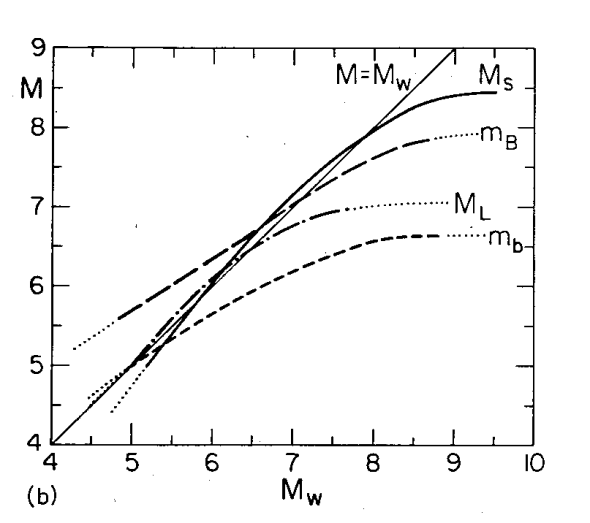
I have not bothered with values under 3.0

The quake above EMSC have as 5.7 mb which would be 6.0 Mw (rounded)
I would guess that they are probably different. For ML they certainly will be as ML is calculated for each area.
Just out of idle curiosity I dumped those calculations you posted into Excel. The orange background is where the crossover between the two scales being compared occurs. They greyed text is where the value exceeds the apparent saturation point according to this chart. (Not terribly accurate but a guideline)

I have not bothered with values under 3.0

The quake above EMSC have as 5.7 mb which would be 6.0 Mw (rounded)
edit on 19/5/2012 by PuterMan because: (no reason given)
Some may find this report from GDACS of interest. It is about the 'false' tsunami warnings from the 2 x 8+ quakes off Indonesia.
ETA: You might want to add GDACS to your links. It is better than RSOE!
Download the zip file here
There are three PDF files in the zip.
I so want the BIG computer screen towards the last page of the main report.
The second report (update 1a) is the most interesting with many tsunami calcs and graphs.
Basically, after a very quick read, I think they are saying the initial forecast was justified as the system did not know it was a strike slip and that despite the fact that the alert was in error and led to panic amongst the population they would not be changing the way they alert.
Personally I am in full agreement with that on the basis that had this (these) been mega thrust quakes there would have been a large tsunami and if the warning had been delayed whist they checked precious time would have been lost.
ETA: You might want to add GDACS to your links. It is better than RSOE!
Two reports and one map have been prepared by JRC to describe the event and to explain the reason for the Red Alert when a much lower impact was occurring.
Download the zip file here
There are three PDF files in the zip.
I so want the BIG computer screen towards the last page of the main report.
The second report (update 1a) is the most interesting with many tsunami calcs and graphs.
Basically, after a very quick read, I think they are saying the initial forecast was justified as the system did not know it was a strike slip and that despite the fact that the alert was in error and led to panic amongst the population they would not be changing the way they alert.
Personally I am in full agreement with that on the basis that had this (these) been mega thrust quakes there would have been a large tsunami and if the warning had been delayed whist they checked precious time would have been lost.
edit on 19/5/2012 by PuterMan because: (no reason given)
UPDATE to post by PuterMan
GFZ Potsdam, GeoAzur etc are coming in at 5.9 Mw so this event was not a 6.2 it would seem.
EMSC is appearing to be much more accurate in the initial forecasts in most cases - except that one yesterday!!
GFZ Potsdam, GeoAzur etc are coming in at 5.9 Mw so this event was not a 6.2 it would seem.
EMSC is appearing to be much more accurate in the initial forecasts in most cases - except that one yesterday!!
reply to post by PuterMan
PuterMan firstly I'd like to thank you for your passion and awarness when it concerns this fragile egg we live on.
I have been along time lurker of ATS but don't post much.
I have a bit of a query. I have been looking on www.iris.edu/seismon/ site on an almost daily basis for over two years now and have noticed over the last say three weeks the lack of earthquake reports.
Has there been a lack of reportable activity over recent weeks and or have you noticed a drop off over this time period?
Cheers Ian
puterman, I wish others (some do) would post earthquakes the way you do! (6.0 chile) then put all the info below it, is much quicker and most of us
want the size and the place first.
This is a really good thread and you all get the info on here really fast! keep up the good work!
This is a really good thread and you all get the info on here really fast! keep up the good work!
Happy Apogee!
If we were on the moon, we'd have reached our furtherest point from the earth. The sun is behind our backs and it's almost on top of us. Soon, like a kid with a magnifying glass, we'll created a small focal point of shadow. And fire. It's an annular eclipse so they call it a fire of fire. Wow. Just like the ring of fire we're always talking about when we think about earthquakes. And amazingly so, the eclipse will start of one part of the ring of fire and cross across the Pacific to the other side of the ring. From one megathrust plate to another. Toyko to 'Mercia.
www.space.com...
The eclipse will cross the toe of Juan de Fuca. But I'm not saying anything siemic will happen. Just like the "Super" moon, a term I don't like, nothing may happen. I mean out of the ordinary. Worldwide quakes almost seem normal. With only a few exceptions. (cough- midwest). I think this new moon is more volcanic in nature. One Alaskan Volcano has been slightly more siemic. Popo is steamy. Too steam. Tooooo much H20. Rocket fuel. Anyway, I'm following that on Volcano Watch.
Edit. Puterman, you were too quick. I am thinking nothing "big" will happen earhquake wise. But I wouldn't be surprised either. I just think it will be volcanic. So, go to volcano watch and tell me what you think about the Alaskan volcano siesmo. Is it having transmission problems, or is it all siesmic. Too used to watching Yellowstone. It's a mess right now. Too much off line. Got an article on upgrades. Regardless, Yellowstone is quiet.
www.wired.com...
Check back here in a bit, I'm going to dump a bunch on news articles I think are interesting before edit window closes, but I got to do something first.
Back. The first thing is a mystery quake that turns out not to be a mystery. What I really like about this story is that it is an elementary school where we finds the signature on their siesmo. This reminds me of someone on this thread writing and displaying their homemade siesmo. No one seemed to take much interest and I was hoping we'd get into that topic more. I would have responded better if I were more diligent and coherent.
www.ktvb.com...
www.ktvb.com...
Next something totally insane. Let's frack up California more than it already is.
www.laweekly.com...
earthsci.org...
How do you fix subsidence? Inflation. Or Injection.
So, you live in the Mid-west United States. Get used to it. East Texas quake makes news in Canada.
www.theweathernetwork.com...&stormfile=Another_earthquake_hits_East_Texas_18_05_2012?ref=ccbox_weather_topstories
There's no mystery here. We already know what's going on.
www.ibtimes.com...
www.news-journal.com... l
Does fracking cause earthquakes? ha
www.ksla.com...
edit on 19-5-2012 by ericblair4891 because: (no reason given)
Yeah, the May 20th date that I've seen described as doom on a dozen websites is coming.
Looks like Alaska might be a contender. Lots of small swarms popping off the past 24 hrs.
Who knows. We shall see. It has been awfully quiet aside from the few 6s.
Looks like Alaska might be a contender. Lots of small swarms popping off the past 24 hrs.
Who knows. We shall see. It has been awfully quiet aside from the few 6s.
reply to post by etrex66
The IRIS seismic monitor only reports mag 4.0 earthquakes upwards, which in effect mean that it only reports magnitude 4.5 for areas outside the US and even then many will not be reported.
In the last year ~5000 M4.5+ were reported by USGS against ~5,500 M4.5+ for EMSC - which also suffers from the same problem but is boosted by Europe having mor mag 4+ than America.
It has been quieter of late for certain, and it is my contention that it will remain so.
You need big quakes to get the numbers of smaller quake up. Japan boosted the mag 4.5+ numbers to over double normal. What really you are seeing is the lack of those aftershocks.
reply to post by ericblair4891
And probably nothing much will happen, but if we get a mag 7 it will be blamed on the eclipse, and so will any mag 6. When the next mag 7 happens and there is no eclipse that fact will be ignored.
At the last supermoon, and the blue moon, Mother Nature refused to play ball and ignored all the pundits. I hope she does so again!
And amazingly so, the eclipse will start of one part of the ring of fire and cross across the Pacific to the other side of the ring. From one megathrust plate to another. Toyko
And probably nothing much will happen, but if we get a mag 7 it will be blamed on the eclipse, and so will any mag 6. When the next mag 7 happens and there is no eclipse that fact will be ignored.
At the last supermoon, and the blue moon, Mother Nature refused to play ball and ignored all the pundits. I hope she does so again!
reply to post by murkraz
I believe the curve for Alaska, as defined on the chart, has actually dropped very slightly.
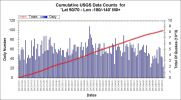
Not disagreeing with you as I have said Alaska may get one soon.
I believe the curve for Alaska, as defined on the chart, has actually dropped very slightly.

Not disagreeing with you as I have said Alaska may get one soon.
This event has been reviewed by a seismologist.
Magnitude
5.9
Date-Time
Saturday, May 19, 2012 at 19:05:19 UTC
Sunday, May 20, 2012 at 05:05:19 AM at epicenter
Time of Earthquake in other Time Zones
Location
39.709°N, 143.345°E
Depth
5.4 km (3.4 miles) (poorly constrained)
Region
OFF THE EAST COAST OF HONSHU, JAPAN
Distances
169 km (105 miles) ESE of Hachinohe, Honshu, Japan
175 km (108 miles) E of Morioka, Honshu, Japan
239 km (148 miles) ESE of Aomori, Honshu, Japan
543 km (337 miles) NNE of TOKYO, Japan
Location Uncertainty
horizontal +/- 13.9 km (8.6 miles); depth +/- 5.5 km (3.4 miles)
Parameters
NST=469, Nph=469, Dmin=257.1 km, Rmss=1.26 sec, Gp= 22°,
M-type=teleseismic moment magnitude (Mw), Version=B
Source
Magnitude: USGS NEIC (WDCS-D)
Location: USGS NEIC (WDCS-D)
Event ID
usb0009tfl
Info
edit on 19-5-2012 by lurksoften because: (no reason
given)
edit on 19-5-2012 by lurksoften because: (no reason given)
edit on 19-5-2012 by lurksoften because: info was
revised
Originally posted by lurksoften
This event has been reviewed by a seismologist.
Magnitude
5.8
Date-Time
Saturday, May 19, 2012 at 19:05:21 UTC
Sunday, May 20, 2012 at 05:05:21 AM at epicenter
Location
39.750°N, 143.202°E
Depth
14.9 km (9.3 miles)
Region
OFF THE EAST COAST OF HONSHU, JAPAN
Distances
167 km (104 miles) ESE (119°) from Hachinohe, Honshu, Japan
177 km (110 miles) E (88°) from Morioka, Honshu, Japan
243 km (151 miles) ESE (119°) from Aomori, Honshu, Japan
546 km (339 miles) NNE (33°) from TOKYO, Japan
Location Uncertainty
horizontal +/- 17.9 km (11.1 miles); depth +/- 6.8 km (4.2 miles)
Parameters
NST=262, Nph=262, Dmin=251.6 km, Rmss=1.1 sec, Gp= 97°,
M-type=regional moment magnitude (Mw), Version=9
Source
U.S. Geological Survey, National Earthquake Information Center:
World Data Center for Seismology, Denver
Event ID
usb0009tfl
Info
thnks,,,
my gut says there is no doubt about it each wave,,they are increasing in boom size,,
but i have no DATA.
Me.
PuterMan, didn't you say that this area more North of the 9 mag last March, is prone to the possibility of a larger 8? Not feeling comfortable with
this swarm. Scroll the pic right.


Heres my take on the 2012/05/19 quake offshore Antofagasta, Chile at ...... geez they can't even agree on what time it was
08:35:08.0 (emsc)
08:35:09(guc)
08:35:10.42(usgs)
08:35:10.6(ras)
08:35:11[geofon)
08:35:20.0 (ldeo)
or where it was
-25.74, -70.66(emsc)
-25.741, -70.858(guc)
-25.783, -70.793(usgs)
-25.8, -70.64(ras)
-25.74, -70.69(geofon)
-25.25, -71.25(ldeo)
or how km deep it was
10(emsc)
83.6(guc)
25.0(usgs)+/- 3.1
33(ras)
30(geofon)
33(ldeo)
Let alone the magnitude
using the (geofon) Mw calculation formula I get;
Finding the average off the mb readings from the networks
USGS mb=5.64/370 [Mw = 0.7813mb + 1.5175] = [color=43C6DB]5.915Mw - posted reading 5.9Mw
EMSC mb=5.75/389 [Mw = 0.7813mb + 1.5175] = [color=43C6DB]6.011Mw - posted reading 5.9Mw
RAS mb= 5.7/10 [Mw = 0.7813mb + 1.5175] = [color=43C6DB]5.97Mw - posted reading 5.7Ms
so converting that Ms to Mw
RAS Ms= 5.7/21 [Mw = 1.2690MS - 1.0436] = [color=43C6DB]6.189Mw
looking at ML, only two sources to work with
USGS ML=6.3/22 [Mw = 0.6960ML + 1.7738] = [color=43C6DB]6.158Mw
DGF/GUC ML= 6.1 [Mw = 0.6960ML + 1.7738] = [color=43C6DB]6.0194Mw - posted reading 6.3Mw
LDEO has 5.8Mw
with my results we get an average of
5.915
6.011
5.97
6.189
6.158
6.0194
36.2624/6 =[color=43C6DB]6.0437Mw
taking it a step further, and another cross reference - arrival times at SNZO
emsc P =08 48 07, S=08 59 00, LR=09 17 21
guc P=08 47 59, S=08 58 44, LR=09 17 20
usgs P=08 48 06, S=08 58 57, LR=09 17 20
ras P=08 48 05, S=08 58 56, LR=09 17 23
geofon P=08 48 07, S=08 58 57, LR=09 17 24
ldeo P=08 48 13, S=08 59 06, LR=09 17 22
the magnitude and depth make no difference to the arrival time at SNZO, you can only tell the size by the height of the trace
the differences that transfer to arrival time differences are the location and time
7 seconds on the P wave
15 seconds on the S wave
4 seconds on the LR waves
SNZO marked. I used emsc, seemed to be in the middle
Sooooooo in conclusion the only clear facts are
"A strong earthquake occurred between 08:35:08.0 and 08:35:20 on 2012/05/19 UTC, at a depth between 10 and 83.6km, in the FE Region 122, offshore Antofagasta/ Atacama, Chile"
Strong meaning 5.5 - 6.5 of any magnitude type
edit on 19-5-2012 by muzzy because: tags
reply to post by PuterMan
I don't think the Ms works too well.
mb and ML seem to match up with some of the network conversions
I don't think the Ms works too well.
mb and ML seem to match up with some of the network conversions
location: Gainesville, GA
My metal filing cabinet has been shaking the items sitting on top of it mildly off and on all afternoon....
Just wondering if anyone else is noticing a mild shaking going off and on.....
This is something I've never noticed happening before...
I've looked for anything going on in the house that could be causing it but the grandbaby was napping at the time and so nothing was really going on in the house other than nap time...lol
Even after the baby woke up nothing has really been going on like washing clothes or running the dishwasher so I find it strange to hear since I've never noticed it before when those appliances are running.
I guess I need to get my lazy butt up and go to the store for the week...
So sorry to go on and on...but I got my butt smacked by Don't tread on me for posting one liners recently...Lord knows why I'm acting like I really care.
Carry on and stay safe...
Geonet fallen asleep on the job again?
Only one quake in the data download for 18th May, same one as on the Recent Quakes list a 2.954ML in the park across the road from 31 Aidanfield Dr, Halswell, Christchurch.
Just had a 4.1 down there just under an hour ago
you can see it on
MQZ
pretty quiet all over NZ lately
Only one quake in the data download for 18th May, same one as on the Recent Quakes list a 2.954ML in the park across the road from 31 Aidanfield Dr, Halswell, Christchurch.
Just had a 4.1 down there just under an hour ago
you can see it on
MQZ
pretty quiet all over NZ lately
Awesome call on Alaska. 5~ Murkraz.
If I was sitting on that lunar lawn chair, I'd be looking square at it.
Here's an article about small earthquakes causing tsunamis.
news.discovery.com...
I'm still kinda wondering about the mid-west. Off-On-Off-On-Off-On. The last cluster began in Arkansas. And ended in Texas. I'm paying attention and know there is a cycle of inter-related forces.
As I said I think the moon will play with magma. Popo had a small swarm of volcanic microquakes in recent hours.

That was the best shot because I wanted the volcanic tremor at the top and the new micro-quakes on the same graph so you can see the different types of stuff on Popo. On this next one a recent gas explosion? What do I know?
Wait. Had to capture another shot cause there was another quake. I knew to watch Popo.
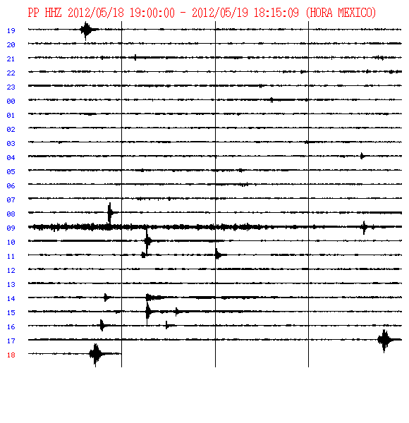
Here's a thing I found that helps me figure out what I'm looking at.
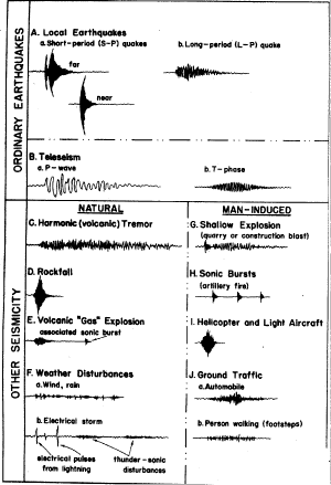
Rock fall?
I should go back to school.
It's not a helicopter is it? I'm making myself crazy.
Look there's more and seemingly regular. I'm watching webcam but don't see helicopters.
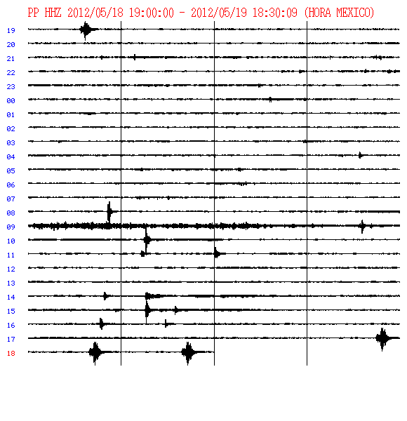
Wow. Talk about regular. About every fifteen minutes now.
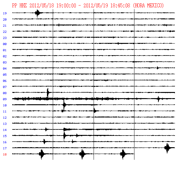
and another. no helios spotted.

If I was sitting on that lunar lawn chair, I'd be looking square at it.
Here's an article about small earthquakes causing tsunamis.
news.discovery.com...
I'm still kinda wondering about the mid-west. Off-On-Off-On-Off-On. The last cluster began in Arkansas. And ended in Texas. I'm paying attention and know there is a cycle of inter-related forces.
As I said I think the moon will play with magma. Popo had a small swarm of volcanic microquakes in recent hours.

That was the best shot because I wanted the volcanic tremor at the top and the new micro-quakes on the same graph so you can see the different types of stuff on Popo. On this next one a recent gas explosion? What do I know?
Wait. Had to capture another shot cause there was another quake. I knew to watch Popo.

Here's a thing I found that helps me figure out what I'm looking at.

Rock fall?
I should go back to school.
It's not a helicopter is it? I'm making myself crazy.
Look there's more and seemingly regular. I'm watching webcam but don't see helicopters.

Wow. Talk about regular. About every fifteen minutes now.

and another. no helios spotted.

edit on 19-5-2012 by ericblair4891 because: (no reason given)
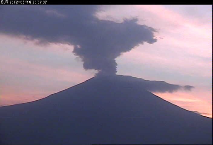
I see him.
edit on 19-5-2012 by ericblair4891 because: (no reason given)
new topics
-
Potter to WHU
World Sports: 3 hours ago -
Dr. Demento
Music: 5 hours ago -
The elephant in the room (wearing a hoodie)
US Political Madness: 5 hours ago
top topics
-
The elephant in the room (wearing a hoodie)
US Political Madness: 5 hours ago, 9 flags -
Green Grapes
General Chit Chat: 16 hours ago, 7 flags -
To become president, Zelensky had to learn Ukrainian
Political Conspiracies: 12 hours ago, 6 flags -
Dr. Demento
Music: 5 hours ago, 4 flags -
Potter to WHU
World Sports: 3 hours ago, 1 flags
active topics
-
The Truth about Migrant Crime in Britain.
Social Issues and Civil Unrest • 38 • : gortex -
Dr. Demento
Music • 11 • : BeyondKnowledge3 -
To become president, Zelensky had to learn Ukrainian
Political Conspiracies • 27 • : Oldcarpy2 -
-@TH3WH17ERABB17- -Q- ---TIME TO SHOW THE WORLD--- -Part- --44--
Dissecting Disinformation • 3976 • : Thoughtful3 -
Los Angeles brush fires latest: 2 blazes threaten structures, prompt evacuations
Mainstream News • 140 • : putnam6 -
The elephant in the room (wearing a hoodie)
US Political Madness • 14 • : Edumakated -
Trump says ownership of Greenland 'is an absolute necessity'
Other Current Events • 70 • : BedevereTheWise -
The Fight for Election Integrity Continues -- Audits, Criminal Investigations, Legislative Reform
2024 Elections • 4370 • : fringeofthefringe -
What Is 'Quad Demic'? Mask Mandate Returns In These US States
Diseases and Pandemics • 42 • : Owlwatcher -
Steering the Titantic from the Drydock.
Rant • 46 • : Owlwatcher
