It looks like you're using an Ad Blocker.
Please white-list or disable AboveTopSecret.com in your ad-blocking tool.
Thank you.
Some features of ATS will be disabled while you continue to use an ad-blocker.
share:
I know that there has been threads about this subject but we should not abandon it,there are some answers that some people must give if it's the
'fracking' pumps water!!
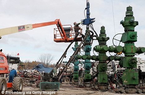
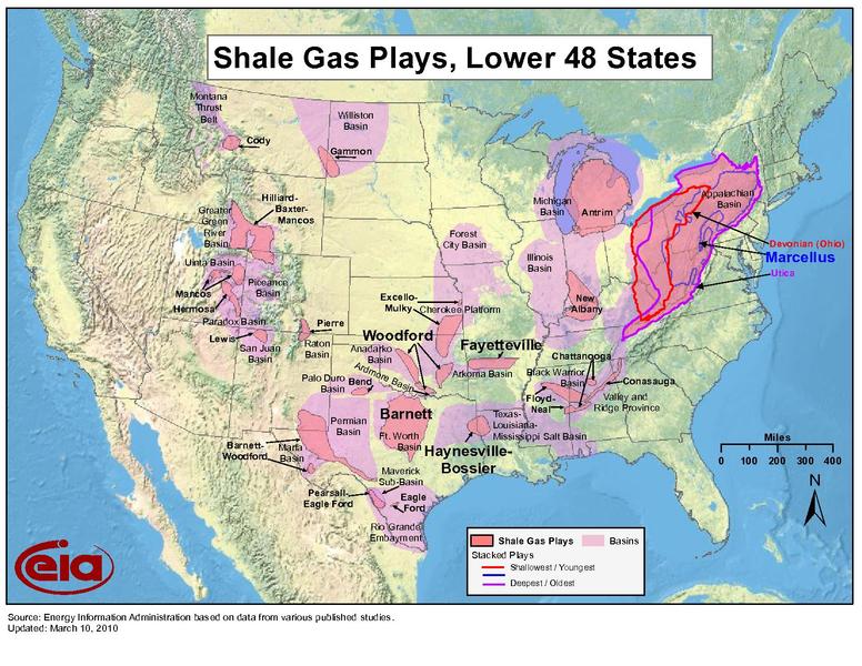
source(thecomingcrisis.blogspot.com...
This is the latest
Magnitude
3.0
Date-Time
Sunday, November 13, 2011 at 09:49:11 UTC
Sunday, November 13, 2011 at 03:49:11 AM at epicenter
Location
35.486°N, 96.840°W
Depth
5 km (3.1 miles) set by location program
Region
OKLAHOMA
Distances
19 km (11 miles) NNE of Shawnee, Oklahoma
61 km (37 miles) E of OKLAHOMA CITY, Oklahoma
62 km (38 miles) ENE of Norman, Oklahoma
68 km (42 miles) SE of Guthrie, Oklahoma
Location Uncertainty
horizontal +/- 4.2 km (2.6 miles); depth fixed by location program
Parameters
NST= 31, Nph= 31, Dmin=6.6 km, Rmss=0.87 sec, Gp= 61°,
M-type="Nuttli" surface wave magnitude (mbLg), Version=6
Source
Magnitude: USGS NEIC (WDCS-D)
Location: USGS NEIC (WDCS-D)
Event ID
usc0006rbk
source(earthquake.usgs.gov...
Oklahoma earthquake possibly caused by controversial energy-drilling process ...Noooooo!..... who would of guessed? - 13th Nov 2011 The reason behind last week's earthquake in Oklahoma is still eluding scientists though they think it might have been connected to the growing use of hydraulic fracturing. The process, commonly called 'fracking', pumps water into the earth in an effort to release natural gas and oil. Scientists first noticed that small earthquakes in Oklahoma- with magnitudes between 1 and 2.8- near a fracking site in August, though they did nothing to stop its usage. Researchers said that there was not enough evidence to say with 'a high degree of certainty' that the small earthquakes were caused by fracking. The small tremors were felt by residents, but were nothing compared to the 5.6 magnitude earthquake that struck the Sooner State last Saturday evening. Scientists are puzzled by the recent seismic activity. It appeared the latest quake occurred on the Wilzetta fault, but researchers may never know for sure. Earthquakes that hit east of the Rocky Mountains are harder to pinpoint because the fault systems are not as well studied as major faults like the San Andreas in California. Arkansas also has seen a big increase in earthquake activity, which residents have blamed on injection wells

source(thecomingcrisis.blogspot.com...
This is the latest
Magnitude
3.0
Date-Time
Sunday, November 13, 2011 at 09:49:11 UTC
Sunday, November 13, 2011 at 03:49:11 AM at epicenter
Location
35.486°N, 96.840°W
Depth
5 km (3.1 miles) set by location program
Region
OKLAHOMA
Distances
19 km (11 miles) NNE of Shawnee, Oklahoma
61 km (37 miles) E of OKLAHOMA CITY, Oklahoma
62 km (38 miles) ENE of Norman, Oklahoma
68 km (42 miles) SE of Guthrie, Oklahoma
Location Uncertainty
horizontal +/- 4.2 km (2.6 miles); depth fixed by location program
Parameters
NST= 31, Nph= 31, Dmin=6.6 km, Rmss=0.87 sec, Gp= 61°,
M-type="Nuttli" surface wave magnitude (mbLg), Version=6
Source
Magnitude: USGS NEIC (WDCS-D)
Location: USGS NEIC (WDCS-D)
Event ID
usc0006rbk
source(earthquake.usgs.gov...
edit on 13-11-2011 by diamondsmith because: Why Oklahoma?
Even if it's not fracking causing the quakes (although, I tend to think it is the cause), how could it possibly be good for the earth in the long
run?...Just me or does anyone else see this as pushing the envelop of what this planet can take before it shakes us like a case of fleas? I really
think this is Guy AR's problem too.
as I type this I notice a new one in the last hour...3.0 according to UGAS....speaking of which is anyone aware of what scale they use? Richter or Mercalli scale....I think most sources use Mercalli but I believe a 3.0 is more sever on that scale so IDK.
as I type this I notice a new one in the last hour...3.0 according to UGAS....speaking of which is anyone aware of what scale they use? Richter or Mercalli scale....I think most sources use Mercalli but I believe a 3.0 is more sever on that scale so IDK.
edit on 13-11-2011 by PutAQuarterIn
because: ETA
Fracking wells only go down a few hundred meters.
3.1 miles is WELL beyond the scope of fracking capabilities. This has already been covered pretty extensively here. What is happening in Oklahoma is NOT related to fracking.
Read this post I made which goes into further detail on fracking tremors and their differences from actual earthquakes..
www.abovetopsecret.com...
edit on 13-11-2011 by projectvxn because: (no reason given)
reply to post by projectvxn
Just take look at this...
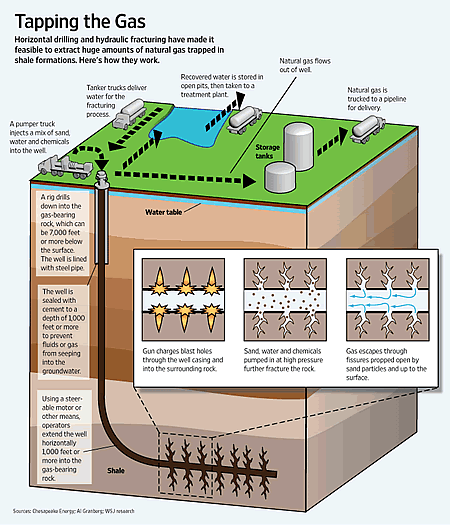
source(www.technovelgy.com...

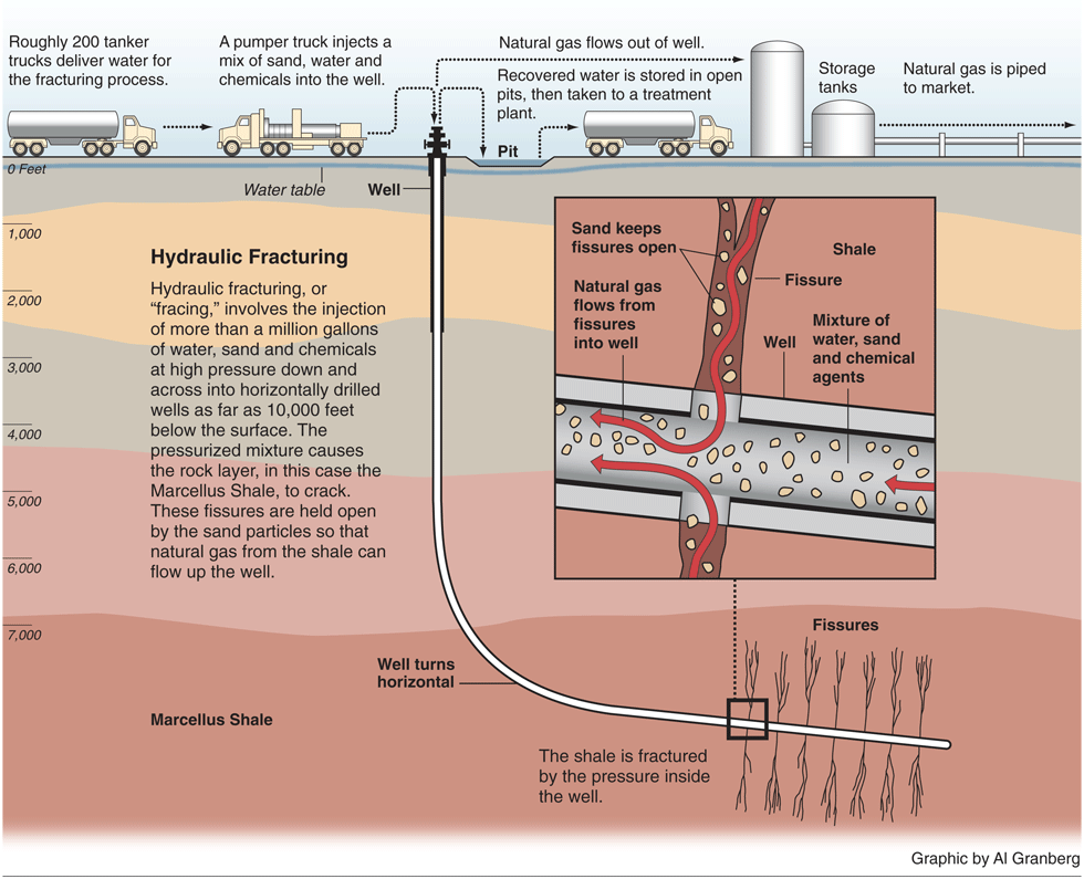
TextCan fracking cause earthquakes? Residents of towns like Cleburn, Texas have high hopes for the natural gas underlying their town - but have concerns about new techniques for getting to it. "Fracking" (or hydraulic fracturing) is a natural gas-exploration technique that uses a slurry of water and chemicals and sand into production wells to create fractures in rock, releasing gas otherwise unobtainable. Five small temblors [in July] have some people pointing the finger at technology that drilling companies use to reach deep into the earth to shatter rock and release new stores of natural gas — the same technology that has made many of the locals rich. Thousands of wells have been drilled in the past five years. Now, a wave of small earthquakes is leading some residents in the north Texas town to link the two developments and some seismic experts to wonder about the cause. The industry says there isn’t any evidence linking the quakes to gas production. Even geophysicists, who take the residents’ concerns seriously and are deploying seismic sensors in the area, say they can’t prove a connection between the drilling and the quakes. Take a look at this graphic that illustrates the process of hydraulic fracturing - "fracking".
source(www.technovelgy.com...
reply to post by diamondsmith
What are you trying to say with all of this exactly?
That fracking 1000 ft. deep is causing earthquakes 3.1miles down?
That isn't the case here, sorry.
I know how the fracking process works. And these strong and DEEP earthquakes aren't being caused by it.
Fracking tremors are VERY shallow.
What are you trying to say with all of this exactly?
That fracking 1000 ft. deep is causing earthquakes 3.1miles down?
That isn't the case here, sorry.
I know how the fracking process works. And these strong and DEEP earthquakes aren't being caused by it.
Fracking tremors are VERY shallow.
reply to post by diamondsmith
Start making sense!!!
Your one word responses with no context don't make any sense. Please get it together.
Start making sense!!!
Your one word responses with no context don't make any sense. Please get it together.
reply to post by projectvxn
A reply made after your post indicates a supporting argument for anthropocentric causes for earthquakes in not the depth and magnitude range.
Furthermore:
Research Org Ernest Orlando Lawrence Berkeley NationalLaboratory,Berkeley,CA(US)
Sponsoring Org Earth Sciences Division
Human activity can and does cause earthquakes. Granted, ost of those quakes will be in the smaller magnitude range. That does not lessen the potential for destuctive outcome however as can be seen by this post.
Regardless of your opinion, the scientific fact is that fracking is acknowledged by the people who do it to cause seismicity.
And as will be noticed by the more astute readers, it is only due to increased public awareness and activity that this symposium was called. Were it not for people like Robin Marks and Susan Frey (see the Arkansas earthquake/fracking thread in my signature), this practice would still be occurring under the radar.
A reply made after your post indicates a supporting argument for anthropocentric causes for earthquakes in not the depth and magnitude range.
Furthermore:
Workshop on induced Seismicity due to fluid injection/production from Energy-Related Applications
Research Org Ernest Orlando Lawrence Berkeley NationalLaboratory,Berkeley,CA(US)
Sponsoring Org Earth Sciences Division
emphasis mine
Recent publicity surrounding induced seismicity at several geothermal and oil and gas sites points out the need to develop improved standards and practices to avoid issues that may unduly inhibit or stop the above technologies from fulfilling their full potential.It is critical that policy makers and the general community be assured that EGS,CO[sub2] sequestration,enhanced oil/gas recovery, and other technologies relying on fluid injections, will be designed to reduce induced seismicity to an acceptable level, and be developed in a safe and cost-effective manner. Induced seismicity is not new - it has occurred as part of many different energy and industrial applications (reservoir impoundment, mining, oilrecovery, construction, wastedisposal, conventional geothermal).With proper study/research and engineering controls, induced seismicity should eventually allow safe and cost-effective implementation of any of these technologies.
Human activity can and does cause earthquakes. Granted, ost of those quakes will be in the smaller magnitude range. That does not lessen the potential for destuctive outcome however as can be seen by this post.
Regardless of your opinion, the scientific fact is that fracking is acknowledged by the people who do it to cause seismicity.
And as will be noticed by the more astute readers, it is only due to increased public awareness and activity that this symposium was called. Were it not for people like Robin Marks and Susan Frey (see the Arkansas earthquake/fracking thread in my signature), this practice would still be occurring under the radar.
reply to post by jadedANDcynical
I didn't claim otherwise. And in the post I made the report from OGS acknowledged that fracking does cause earthquakes between a magnitude of 1-2. HOWEVER it also said these earthquakes are very shallow. It is hard for me to believe that fracking is causing EQs at a depth of 3-5 miles considering that is the average depth of the quakes in Oklahoma.
I didn't claim otherwise. And in the post I made the report from OGS acknowledged that fracking does cause earthquakes between a magnitude of 1-2. HOWEVER it also said these earthquakes are very shallow. It is hard for me to believe that fracking is causing EQs at a depth of 3-5 miles considering that is the average depth of the quakes in Oklahoma.
There's a fault line where they are having earthquakes in Oklahoma.
reply to post by texastig
A map please?or maybe I give you the map and you show me!!
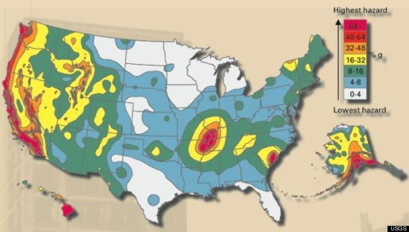
www.huffingtonpost.com...(source

www.huffingtonpost.com...(source
edit on 13-11-2011 by diamondsmith because: Map
reply to post by diamondsmith
Man,I hate to do this,but there is a fault right there associated with the quakes.
www.okgeosurvey1.gov...
Man,I hate to do this,but there is a fault right there associated with the quakes.
Snapshot of earthquake locations from the recent earthquakes page. Black lines represent faults. As you can see these earthquakes are clearly associated with a known fault.
www.okgeosurvey1.gov...
Originally posted by kdog1982
reply to post by diamondsmith
Man,I hate to do this,but there is a fault right there associated with the quakes.
Snapshot of earthquake locations from the recent earthquakes page. Black lines represent faults. As you can see these earthquakes are clearly associated with a known fault.
www.okgeosurvey1.gov...
But,also notice all those other small quakes surrounding the 5.6 on the fault line.
Alot of those where shallow as in 1 mile in depth.
1 mile =5280 feet.
Now,I saw in a post above somewhere were they were fracking around 7000 feet.
Those are suspicious as to have been caused by fracking.
Now with all those other small quakes,is it not feasible to perhaps think that they could have triggered that 5.6 quake?And that fracking indirectly may have triggered that quake which would have otherwise remain quiet?
Shaking a place where there is stress building up therefore causing it to release some of that stress.
Just a thought.
edit on 13-11-2011 by kdog1982 because: (no reason given)
Sorry folks. Not possible imo.
Ive been in the oilfield most of my working life and currently doing the same, though, now on the office side of things...
Keep this in mind...
For every bit of whatever comming out of the hole, it is replaced by weighted mud, synthetic or other, that will fill every bit of space that is being opened to pull out the gases. Now, we're also speaking about very small fractures in the rock and only so many hundreds of feet down. Earthquakes that take place miles down seem to be on a completely diffrent segment of rock alltogether. A few hundred feet vs a few miles? think...
If this was harmful, you can bet, louisiana would have a SERIOUS amount of eathquakes. You folks have no IDEA how many wells, abandoned wells, active wells, frack wells, etc etc etc... we have in louisiana. If any drilling at all caused any kind of earthquake, you can bet, we would most definatly know about it. To be honest, earthquakes are so rare in louisiana, that the last one I knew of happened when I was 5 and we didnt even feel it. That's nearly 40 years ago. The only thing similar happened when I was around 17, that's when Exxon blew up on the levey, downtown Baton Rouge. That thew me out of bed, actually.
Yes, there are many, MANY problems in the oilfield, but to be honest, this isnt one of them. The worse thing that could happen here is, someone could be drinking from a contaminated water well. Yes, that's pretty bad, but no, sorry, no earthquakes. These holes are no bigger around than your leg in many cases. At most, no bigger round than your average big guy.
reply to post by theRhenn
The underlined portion of the abstract in my prior post s at you. The Dept. of Energy s @ you.
Lets take a look at the two "signficant" quakes, shall we?
And
Pay special attention to both the reported and uncertainty of the depth.
The 4.7 took place 2.5 ± 1.7 miles down. The 5.6 was 3.1 ± 1.7 miles down. This puts them in the range of .8 to 4.5 miles and 1.4 to 4.8 miles down respectively. The lower limit for each of these two quakes is well within the depth reached by fracking.
Is this incontovertable proof that these quakes are fracking related? Not necessarily.
To say that there is no way that fracking can cause earthquakes is ignorance at best and purposeful misdirection at worse.
The underlined portion of the abstract in my prior post s at you. The Dept. of Energy s @ you.
Lets take a look at the two "signficant" quakes, shall we?
Magnitude 4.7
Date-Time Saturday, November 05, 2011 at 07:12:45 UTC Saturday,November 05,2011at 02:12:45AM at epicenter Time of Earthquakein otherTimeZones
Location 35.553°N, 96.748°W
Depth 4 km (2.5 miles)
Region OKLAHOMA
Distances 33 km (20 miles) NE of Shawnee, Oklahoma 67 km (41 miles) W of Okmulgee, Oklahoma 68 km (42 miles) SSE of Stillwater, Oklahoma 75 km (46 miles) E of OKLAHOMA CITY, Oklahoma
Location Uncertainty horizontal+/- 11.8 km (7.3miles);depth +/- 2.8km (1.7miles)
Parameters NST=148, Nph=151, Dmin=24.5 km, Rmss=0.85 sec, Gp= 25°, M-type=body wave magnitude (Mb), Version=C
Source Magnitude: USGSNEIC (WDCS-D) Location: USGSNEIC (WDCS-D)
Event ID usb0006k8b
And
Magnitude 5.6
Date-Time Sunday, November 06, 2011 at 03:53:10 UTC Saturday,November 05,2011at 10:53:10PM at epicenter Time of Earthquakein otherTimeZones
Location 35.537°N, 96.747°W
Depth 5 km (3.1 miles)
Region OKLAHOMA
Distances 8 km (5 miles) NW (317°) from Prague, OK 10 km (6 miles) SE (141°) from Sparks, OK 14 km (9 miles) ENE (72°) from Meeker, OK 72 km (44 miles) E (85°) from Oklahoma City, OK 304 km (189 miles) N (1°) from Dallas, TX
Location Uncertainty horizontal+/- 10.5 km (6.5miles);depth +/- 2.8km (1.7miles)
Parameters NST=189, Nph=192, Dmin=26.7 km, Rmss=1.06 sec, Gp= 29°, M-type=centroid moment magnitude (Mw), Version=C
Source Magnitude: USGSNEIC (WDCS-D) Location: USGSNEIC (WDCS-D)
Event ID usb0006klz
Pay special attention to both the reported and uncertainty of the depth.
The 4.7 took place 2.5 ± 1.7 miles down. The 5.6 was 3.1 ± 1.7 miles down. This puts them in the range of .8 to 4.5 miles and 1.4 to 4.8 miles down respectively. The lower limit for each of these two quakes is well within the depth reached by fracking.
Is this incontovertable proof that these quakes are fracking related? Not necessarily.
To say that there is no way that fracking can cause earthquakes is ignorance at best and purposeful misdirection at worse.
new topics
-
Potter to WHU
World Sports: 5 hours ago -
Dr. Demento
Music: 7 hours ago -
The elephant in the room (wearing a hoodie)
US Political Madness: 7 hours ago
top topics
-
The elephant in the room (wearing a hoodie)
US Political Madness: 7 hours ago, 12 flags -
Green Grapes
General Chit Chat: 17 hours ago, 7 flags -
To become president, Zelensky had to learn Ukrainian
Political Conspiracies: 13 hours ago, 6 flags -
Dr. Demento
Music: 7 hours ago, 5 flags -
Potter to WHU
World Sports: 5 hours ago, 2 flags
active topics
-
Los Angeles brush fires latest: 2 blazes threaten structures, prompt evacuations
Mainstream News • 173 • : WeMustCare -
The Truth about Migrant Crime in Britain.
Social Issues and Civil Unrest • 42 • : gortex -
Post A Funny (T&C Friendly) Pic Part IV: The LOL awakens!
General Chit Chat • 8007 • : underpass61 -
Planned Civil War In Britain May Be Triggered Soon
Social Issues and Civil Unrest • 29 • : AdultMaleHumanUK -
President Carter has passed
Mainstream News • 47 • : xuenchen -
The elephant in the room (wearing a hoodie)
US Political Madness • 19 • : xuenchen -
Trump says ownership of Greenland 'is an absolute necessity'
Other Current Events • 85 • : Oldcarpy2 -
S.C. Jack Smith's Final Report Says Trump Leads a Major Conspiratorial Criminal Organization!.
Political Conspiracies • 44 • : Vermilion -
The Acronym Game .. Pt.4
General Chit Chat • 1038 • : Moon68 -
The Fight for Election Integrity Continues -- Audits, Criminal Investigations, Legislative Reform
2024 Elections • 4371 • : WeMustCare

