It looks like you're using an Ad Blocker.
Please white-list or disable AboveTopSecret.com in your ad-blocking tool.
Thank you.
Some features of ATS will be disabled while you continue to use an ad-blocker.
share:
Where are you?
Baby Boomers, baby boomers.
POP! POP! POP!
Wavy tumours, wavy tumours.
STOP! STOP! STOP!
Click-clack, frick-frack-
Yabba Dabba DOO!
Tick-tack, knick-knack.
Where is Scooby Doo?
Oh, what's that smell?
in my well
I need to fetch some water.
Oh, Bloody Hell.
Who can tell-
if posion's in the fodder.
cleantechnica.com...
www.law.upenn.edu...
www.abc4.com...
edit on 13-11-2011 by ericblair4891 because: (no reason given)
reply to post by ericblair4891
Hi Eric
The earth starts to rumble,
I feel like I am going to stumble.
Everywhere starts to shake,
I hear someone shout
Get under a desk for goodness sake!
I know what’s going on,
It sounds like a great, big bomb.
People are weeping,
Car horns are beeping.
The earth plates are moving,
Although it’s not very soothing.
I hear the crust crumble,
As it starts to tumble.
I’m glad it’s all over,
I didn’t think they occurred in Dover.
I can now carry on with my work,
Now everyone has stopped going berserk.
source(www.sln.org.uk...
Originally posted by PuterMan
reply to post by kdog1982
the rock 15 miles below is lubricated with highly pressurized water
Source in your link.
2 things here
(1)They have been fracking the San Andreas? (pressurised water)
(2)The scientists have not come up with a suggestion as to how this pressurised water got there. They will tell you it percolated down from above. They are stupid. Free draining water will not 'percolate' into a high pressure area.
I believe that this water is from the source of ALL the water on the planet and is the product of abiotic hydrocarbon production. The name alone says it - HYDROcarbon.
Not fracking (that I've heard of) but drilling for oil for 50+ years just east of the fault...
I do think scientists have explained how high pressurized water got there. As I understand plate tectonic theory, including subduction zones and spreading ridges, seawater is incorporated into newly formed basaltic oceanic plates as water-bearing minerals. As the oceanic lithosphere ages, it cools, becomes more dense, and is overlain by a considerable amount of water-rich sediments (mostly clays).
When this oceanic lithosphere is subducted (which is theorized to have happened to the Farallon plate along the west coast of California. Second source from USGS), the water trapped in the sediments and water-rich minerals (such as amphiboles) is released due to mantle dewatering and flux melting. The water rises through the overlying mantle wedge were it leads to related volcanic arc eruptions. Another source
"Free draining water" (meteoric water) can "percolate" down, but only 5-10km in most areas. Source
Here is an article on both meteoric and magmatic fluids (including water) weakening the San Andreas Fault Source
And one more on magmatic water in the crust...www.scitopics.com...
I'm not very good at explaining this, but I think it shows a mechanism for water to be found fairly deep in the crust.
edit on 11/13/2011 by
Olivine because: to correct mistake
edit on 11/13/2011 by Olivine because: and another...on and on they go
reply to post by PuterMan
I have understood that the tidal forces act on fault systems already hair-trigger cocked etc.
Nevertheless, it seems like the list of 6 or larger quakes you listed had some above average--above chance tendencies to cluster either close to the quake or close to the antipodal point from the quake.
Is that just a rare artificact of true chance or is there really something there.
Seems to me some basic stats would ferret that out a bit more.
imho.
reply to post by Olivine
That was tongue in cheek!!
All of it, the articles, subduction and the abiotic theories are mainly supposition. I had written a long reply but I canned it as the scientists are no more right than the other theories and I have run out of energy to fight just now.
Not fracking (that I've heard of)
That was tongue in cheek!!
All of it, the articles, subduction and the abiotic theories are mainly supposition. I had written a long reply but I canned it as the scientists are no more right than the other theories and I have run out of energy to fight just now.
reply to post by PuterMan
No fighting...never.....just friendly conversation.
And I here you about no energy to debate--they are all just theories, some, better able to describe what we see (and can't see) about our planet than others.
Btw, I enjoyed the first bit of work you've done on the moon--and I'm sure you will have plenty of time to finish it.
Take care, PM
What'cha gonna drink when the water's turnin' black?
Where ya gonna go when they're done with the frack?
Baby wants it's babba,
baby wants a babba
What'cha gonna do? What'cha gonna do?
Baby wants its babba,
baby wants a babba.
but she don't like goo.
and she don't like you.
My water's got a shimmy, my water's got a sheen.
No use doing laundry 'cause nothing's coming clean.
Took a glass to the mayor and said, "Here, have a drink."
He just shook his head. Man, it makes you think.
Norma's got a well and her well went boom,
It could have been much worse, coulda been her tomb.
Louie had some cows, tried to be the wiser,
Tried to tap the ground, got himself a geyser.
What'cha gonna drink when the water's turning black?
Where ya gonna go when they're done with the frack?
Baby wants its babba,
baby wants a badda.
What'cha gonna do? What'cha gonna do?
Baby wants its babba,
baby wants a babba.
But she don't like goo.
and she don't like you.
The town we had a meeting, they came from miles around.
All had heard the rumble, the shaking of the ground.
One man says he's listening, the other says, "I know."
Damn shame it's way too late, when my water starts to glow.
Now it's just Perrier and water-loads by the truck,
Called my man in Washington but he don't give a flying
Once she's gone- she ain't ever never coming back
Once she's gone- she's gone like the frack.
Whatcha gonna drink when the water's turning black?
Where ya gonna go when they're done with the frack?
Baby wants its babba,
baby wants a babba
What'cha gonna do? What'cha gonna do?
Baby wants its babba,
baby wants a babba.
But she don't like goo.
and she don't like you.
Where ya gonna go when they're done with the frack?
Baby wants it's babba,
baby wants a babba
What'cha gonna do? What'cha gonna do?
Baby wants its babba,
baby wants a babba.
but she don't like goo.
and she don't like you.
My water's got a shimmy, my water's got a sheen.
No use doing laundry 'cause nothing's coming clean.
Took a glass to the mayor and said, "Here, have a drink."
He just shook his head. Man, it makes you think.
Norma's got a well and her well went boom,
It could have been much worse, coulda been her tomb.
Louie had some cows, tried to be the wiser,
Tried to tap the ground, got himself a geyser.
What'cha gonna drink when the water's turning black?
Where ya gonna go when they're done with the frack?
Baby wants its babba,
baby wants a badda.
What'cha gonna do? What'cha gonna do?
Baby wants its babba,
baby wants a babba.
But she don't like goo.
and she don't like you.
The town we had a meeting, they came from miles around.
All had heard the rumble, the shaking of the ground.
One man says he's listening, the other says, "I know."
Damn shame it's way too late, when my water starts to glow.
Now it's just Perrier and water-loads by the truck,
Called my man in Washington but he don't give a flying
Once she's gone- she ain't ever never coming back
Once she's gone- she's gone like the frack.
Whatcha gonna drink when the water's turning black?
Where ya gonna go when they're done with the frack?
Baby wants its babba,
baby wants a babba
What'cha gonna do? What'cha gonna do?
Baby wants its babba,
baby wants a babba.
But she don't like goo.
and she don't like you.
This event has been reviewed by a seismologist.
earthquake.usgs.gov...
GFZ - 6.5
GeoAu - 6.6
EMSC - 6.6
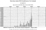
Biggest trace (on LISS) appears to be Davao, Philippines
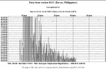
interesting how 6600km away the trace is reversed (never noticed that before )
Magnitude 6.6
Date-Time
Monday, November 14, 2011 at 04:05:12 UTC
Monday, November 14, 2011 at 01:05:12 PM at epicenter
Location 0.954°S, 126.864°E
Depth 19.4 km (12.1 miles)
Region MOLUCCA SEA
Distances
200 km (124 miles) SSW of Ternate, Moluccas, Indonesia
337 km (209 miles) NNW of Ambon, Moluccas, Indonesia
853 km (530 miles) N of DILI, Timor-Leste
1347 km (836 miles) NNW of DARWIN, Northern Territory, Australia
Location Uncertainty
horizontal +/- 13.1 km (8.1 miles); depth +/- 5.4 km (3.4 miles)
Parameters
NST=173, Nph=178, Dmin=455.3 km, Rmss=1.19 sec, Gp= 29°,
M-type=regional moment magnitude (Mw), Version=9
Source
Magnitude: USGS NEIC (WDCS-D)
Location: USGS NEIC (WDCS-D)
Event ID
usc0006rlp
earthquake.usgs.gov...
GFZ - 6.5
GeoAu - 6.6
EMSC - 6.6
Biggest trace (on LISS) appears to be Davao, Philippines

interesting how 6600km away the trace is reversed (never noticed that before )

edit on 13-11-2011 by muzzy because: (no reason given)
To add to your notification, muzzy.
Pacific Tsunami Warning Center
AN EARTHQUAKE HAS OCCURRED WITH THESE PRELIMINARY PARAMETERS
ORIGIN TIME - 0405Z 14 NOV 2011
COORDINATES - 1.1 SOUTH 126.9 EAST
DEPTH - 50 KM
LOCATION - SOUTHERN MOLUCCA SEA
MAGNITUDE - 6.6
EVALUATION
NO DESTRUCTIVE WIDESPREAD TSUNAMI THREAT EXISTS BASED ON
HISTORICAL EARTHQUAKE AND TSUNAMI DATA.
HOWEVER - EARTHQUAKES OF THIS SIZE SOMETIMES GENERATE LOCAL
TSUNAMIS THAT CAN BE DESTRUCTIVE ALONG COASTS LOCATED WITHIN
A HUNDRED KILOMETERS OF THE EARTHQUAKE EPICENTER. AUTHORITIES
IN THE REGION OF THE EPICENTER SHOULD BE AWARE OF THIS
POSSIBILITY AND TAKE APPROPRIATE ACTION.
Pacific Tsunami Warning Center
reply to post by murkraz
sweet
I don't normally put PTWC on as the GeoAu use that as their preliminary data anyway (its on that page)
sweet
I don't normally put PTWC on as the GeoAu use that as their preliminary data anyway (its on that page)
Warning! PuterMan the following source of info might make you sick!
The following as Santorini
2011-11-14 03:31:12 2.7 17 Km
2011-11-13 09:44:28 2.7 25 Km
2011-11-13 08:47:14 2.5 18 Km
2011-11-13 08:12:14 2.7 16 Km
2011-11-13 17:27:21 3.7 94 Km
EDIS
RSOE EDIS have also added Santorini to their list of Supervolcs!
"November 13, 2011 – GREECE – Seismic activity beneath Santorini volcano continues to be slightly above normal levels. Beginning since July this year, an there is elevated activity in a SW-NE trending zone passing through Nea Kameni and the submarine Kolumbos volcano NE of Santorini. The alignment (also known as the Kameni and Kolumbus lines) is a ca. 2 km wide zone parallel to a tectonic horst and graben structure of the crystalline basement of the area. Most of the known volcanic vents of Santorini during the past 2 million years were located on this alignment, more precisely either on its southern boundary (Kameni line) or on its northern boundary (Kolumbus line). Lacking other data sources, the information visible on the location and number of earthquakes is too weak, other than to vaguely speculate that the current earthquake activity around Santorini could be a precursor to new activity from this volcano. Santorini’s last eruption was in 1950. –Volcano Discovery
The devastating volcanic eruption of Santorini at Thera has become the most famous single event in the Aegean before the fall of Troy. It may have been one of the largest volcanic eruptions on Earth in the last few thousand years, with an estimated 7 on the VEI (volcanic explosivity index). -Wikipedia
theextinct... ionprotocol.wordpress.com/2011/11/13/number-of-earthquakes-at-santorini-continues-at-slightly-elevated-levels/
Rainbows
Jane
edit on 14-11-2011 by angelchemuel because: Supervolc
update on post by muzzy
USGS & GFZ downgraded to 6.3Mw
RAS in with 6.1 Ms / 6.5mb
BMGK
USGS & GFZ downgraded to 6.3Mw
RAS in with 6.1 Ms / 6.5mb
BMGK
Date 14/11/2011-11:05:12 UTC+7
Magnitude 6.4 RS (ML)
Depth 10 Km
Location 0.93 S 126.91 E
Information:
The quake's epicenter was at sea 69 km Southwest Labuha
Felt (MMI):
IV - V Labuha, II - III Ternate, II - III Namlea,
edit on 14-11-2011 by muzzy because: (no reason given)
Quake off east Indonesia panics many; no tsunami
By Niniek Karmini
Associated Press / November 14, 2011
www.boston.com/news/world/asia/articles/2011/11/14/quake_off_east_indonesia_panics_many_no_tsunami/
By Niniek Karmini
Associated Press / November 14, 2011
www.boston.com/news/world/asia/articles/2011/11/14/quake_off_east_indonesia_panics_many_no_tsunami/
(...)
Many people in Ternate, the town in North Maluku province that was closest to the epicenter, scurried from shaking buildings, said George Rajaloa, a resident.
"I ran with everyone else," he said.
Suhardjono, from the Indonesian meteorological and geophysics agency, said at that magnitude and depth there was no danger of tsunami.
But residents fled beaches all the same
(...)
Earthquake Details
This event has been reviewed by a seismologist.
Magnitude
3.7
Date-Time
Monday, November 14, 2011 at 06:51:39 UTC
Sunday, November 13, 2011 at 11:51:39 PM at epicenter
Time of Earthquake in other Time Zones
Location
43.050°N, 103.502°W
Depth
5 km (3.1 miles)
Region
SOUTH DAKOTA
Distances
42 km (26 miles) S of Hot Springs, South Dakota
47 km (29 miles) WNW of Chadron, Nebraska
76 km (47 miles) W of Pine Ridge, South Dakota
293 km (182 miles) WSW of PIERRE, South Dakota
Location Uncertainty
horizontal +/- 10.1 km (6.3 miles); depth +/- 3.1 km (1.9 miles)
Parameters
NST= 79, Nph= 97, Dmin=126.9 km, Rmss=0.87 sec, Gp= 47°,
M-type="Nuttli" surface wave magnitude (mbLg), Version=5
Source
Magnitude: USGS NEIC (WDCS-D)
Location: USGS NEIC (WDCS-D)
Event ID
usc0006rmy
The largest earthquakes within 100 miles of Hot Springs, South Dakota were a 4 Magnitude in 1990 and a 3.7 Magnitude in 1996.
South Dakota EQ History
Magnitude mb 4.6
Region AZORES ISLANDS, PORTUGAL
Date time 2011-11-14 11:34:57.0 UTC
Location 39.67 N ; 29.55 W
Depth 8 km
Distances 1738 km NW San cristóbal de la laguna (pop 139,928 ; local time 11:34:57.8 2011-11-14)
230 km NW Angra (pop 12,045 ; local time 10:34:57.8 2011-11-14)
148 km NW Ribeira grande (pop 5,198 ; local time 10:34:57.8 2011-11-14)
EMSC
Rainbows
Jane
Source parameters not yet reviewed by a
reply to post by angelchemuel
RSOE and The Extinction Protocol in one post !!!!! I may never recover
===================================
The policy of changing magnitudes after 7 days I have come to the conclusion is absolutely deliberate.
Once again a magnitude has changed and this time, as I have seen before, the quake appears on both list and I have managed to snag the details.
The 7 day listing (Nicaragua at the bottom)
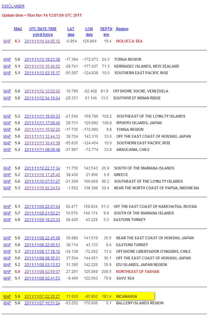
And the 8-30 day listing
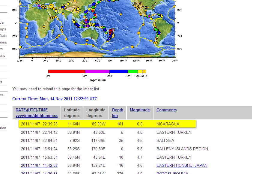
The 8-30 day is in limbo as there are no links. There is probably not much point in going to the pages after 23:00 UTC as the changeover will be gone but in the meantime: 7 day list and 8-30 day list
When it has gone off the 7 day list the new links for the neic version will appear on the 8-30 days list.
From the QED text listing
Sorry but this HAS to be deliberate.
RSOE and The Extinction Protocol in one post !!!!! I may never recover
===================================
The policy of changing magnitudes after 7 days I have come to the conclusion is absolutely deliberate.
Once again a magnitude has changed and this time, as I have seen before, the quake appears on both list and I have managed to snag the details.
The 7 day listing (Nicaragua at the bottom)

And the 8-30 day listing

The 8-30 day is in limbo as there are no links. There is probably not much point in going to the pages after 23:00 UTC as the changeover will be gone but in the meantime: 7 day list and 8-30 day list
When it has gone off the 7 day list the new links for the neic version will appear on the 8-30 days list.
From the QED text listing
223526.8 11.602N 85.906W 181D A 1.0 120 350 NICARAGUA. MW 6.0 (WCMT), 6.1 (GS), 6.0 (UCMT)
Sorry but this HAS to be deliberate.
edit on 14/11/2011 by PuterMan because: (no reason given)
reply to post by angelchemuel
OK, I have cleaned up so let's get back to business.
Santorini is bounded by a rectangle 36N, 25W / 36.5N, 26W. In that area in the past 30 days the following earthquakes have occurred according to EMSC list for quakes over Mag 2.0
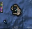
The listing of those is
From the cumulative numbers on the 365 day plot below you can see that there is a very minor increase in the past few days, but less than in June.
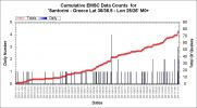
Here is that 'tail end' part

Looking at the cumulative energy for the past 180 days in order to cover the June quakes and the current ones we get a bit of a surprise. There must have been a single larger quake in August which just goes to show why you cannot use numbers. The current energy release pales into insignificance as does the June one, even though the numbers are higher.
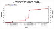
Is there a problem at Santorini? I personally don't believe so, but them I am not a doom-monger so what do I know?
OK, I have cleaned up so let's get back to business.
Santorini is bounded by a rectangle 36N, 25W / 36.5N, 26W. In that area in the past 30 days the following earthquakes have occurred according to EMSC list for quakes over Mag 2.0

The listing of those is
Date/Time UTC,Latitude,Longitude,Magnitude,Depth(Km),Location
2011-11-14 09:33:21, 36.399, 25.395, 2.8, 4.0, Dodecanese Isls. Greece
2011-11-14 03:31:12, 36.377, 25.502, 2.7, 17.0, Dodecanese Isls. Greece
2011-11-13 17:27:38, 36.415, 25.345, 2.5, 4.0, Dodecanese Isls. Greece
2011-11-12 18:12:05, 36.297, 25.279, 2.1, 10.0, Dodecanese Isls. Greece
2011-11-12 16:08:01, 36.241, 25.340, 2.3, 2.0, Dodecanese Isls. Greece
2011-11-12 11:00:37, 36.416, 25.423, 2.3, 8.0, Dodecanese Isls. Greece
2011-11-05 23:28:37, 36.448, 25.489, 2.0, 5.0, Dodecanese Isls. Greece
2011-11-05 18:19:51, 36.260, 25.375, 2.0, 10.0, Dodecanese Isls. Greece
2011-11-01 11:36:22, 36.438, 25.422, 2.9, 10.0, Dodecanese Isls. Greece
2011-10-25 06:06:52, 36.401, 25.535, 2.5, 2.0, Dodecanese Isls. Greece
2011-10-19 18:28:45, 36.397, 25.411, 2.7, 6.0, Dodecanese Isls. Greece
2011-10-18 18:35:43, 36.405, 25.412, 2.4, 3.0, Dodecanese Isls. Greece
2011-10-15 12:39:05, 36.415, 25.415, 2.5, 6.0, Dodecanese Isls. Greece
2011-10-15 12:02:15, 36.386, 25.492, 2.8, 2.0, Dodecanese Isls. Greece
From the cumulative numbers on the 365 day plot below you can see that there is a very minor increase in the past few days, but less than in June.

Here is that 'tail end' part

Looking at the cumulative energy for the past 180 days in order to cover the June quakes and the current ones we get a bit of a surprise. There must have been a single larger quake in August which just goes to show why you cannot use numbers. The current energy release pales into insignificance as does the June one, even though the numbers are higher.

Is there a problem at Santorini? I personally don't believe so, but them I am not a doom-monger so what do I know?
reply to post by murkraz
EMSC data just came in now - rather late. 2nd line is EMSC
EMSC data just came in now - rather late. 2nd line is EMSC
Date/Time UTC,Latitude,Longitude,Magnitude,Depth(Km),Location
2011-11-14 06:51:39, 43.049, -103.502, 3.7, 5.0, South Dakota
2011-11-14 06:51:38, 43.059, -103.383, 4.4, 10.0, South Dakota
reply to post by PuterMan
Considering the relative quake mag numbers that's a heck of a difference in magnitude. I mean, a 4.4 is five times bigger than a 3.7 and more than 11 times stronger in energy release. Them's no small potatoes.
I wonder who's closest to the real figure? Ditto for depth. And why so different?
Not implying anything, just thinking out loud.
Mike
Magnitude mb 4.6
Region TIMOR REGION
Date time 2011-11-14 13:20:13.0 UTC
Location 9.82 S ; 124.73 E
Depth 12 km
Distances 133 km E Kupang (pop 282,396 ; local time 21:20:13.4 2011-11-14)
49 km E Soe (pop 27,717 ; local time 21:20:13.4 2011-11-14)
Source parameters reviewed by a seismologist
EMSC
Rainbows
Jane
Region TIMOR REGION
Date time 2011-11-14 13:20:13.0 UTC
Location 9.82 S ; 124.73 E
Depth 12 km
Distances 133 km E Kupang (pop 282,396 ; local time 21:20:13.4 2011-11-14)
49 km E Soe (pop 27,717 ; local time 21:20:13.4 2011-11-14)
Source parameters reviewed by a seismologist
EMSC
Rainbows
Jane
new topics
-
Don't cry do Cryo instead
General Chit Chat: 3 hours ago -
Tariffs all around, Except for ...
Predictions & Prophecies: 5 hours ago -
Gen Flynn's Sister and her cohort blow the whistle on DHS/CBP involvement in child trafficking.
Whistle Blowers and Leaked Documents: 9 hours ago
top topics
-
Trump sues media outlets -- 10 Billion Dollar lawsuit
US Political Madness: 15 hours ago, 24 flags -
Bucks County commissioners vote to count illegal ballots in Pennsylvania recount
2024 Elections: 14 hours ago, 22 flags -
How long till it starts
US Political Madness: 17 hours ago, 17 flags -
Fired fema employee speaks.
US Political Madness: 16 hours ago, 10 flags -
Gen Flynn's Sister and her cohort blow the whistle on DHS/CBP involvement in child trafficking.
Whistle Blowers and Leaked Documents: 9 hours ago, 8 flags -
Don't cry do Cryo instead
General Chit Chat: 3 hours ago, 4 flags -
Anybody else using Pomodoro time management technique?
General Chit Chat: 12 hours ago, 3 flags -
Tariffs all around, Except for ...
Predictions & Prophecies: 5 hours ago, 3 flags
active topics
-
How can you defend yourself when the police will not tell you what you did?
Posse Comitatus • 83 • : Freeborn -
Tariffs all around, Except for ...
Predictions & Prophecies • 10 • : network dude -
Oligarchy It Is Then
Short Stories • 14 • : UKTruth -
Don't cry do Cryo instead
General Chit Chat • 1 • : angelchemuel -
Mike Tyson returns 11-15-24
World Sports • 54 • : angelchemuel -
President-Elect DONALD TRUMP's 2nd-Term Administration Takes Shape.
Political Ideology • 205 • : WeMustCare -
On Nov. 5th 2024 - AMERICANS Prevented the Complete Destruction of America from Within.
2024 Elections • 155 • : WeMustCare -
The Trump effect 6 days after 2024 election
2024 Elections • 143 • : cherokeetroy -
Bucks County commissioners vote to count illegal ballots in Pennsylvania recount
2024 Elections • 21 • : Irishhaf -
60s-70s Psychedelia
Music • 54 • : gort69
