It looks like you're using an Ad Blocker.
Please white-list or disable AboveTopSecret.com in your ad-blocking tool.
Thank you.
Some features of ATS will be disabled while you continue to use an ad-blocker.

Quake Watch 2010
page: 142share:
NZ 22nd May UTC
One offshore 20km north of me, 3.5ML, 10:25pm last night, didn't feel it.
Couple of deep ones this morning.
REF,LAT,LONG,DATE/TIME UTC,DEPTH, MAG,LOCATION
3310920, -39.99864, 176.76842, 2010/5/22 2:37:20.7, 54, 3.405, E of Waipukurau, Hawkes Bay
3311087, -40.73288, 175.02596, 2010/5/22 10:25:45.0, 41, 3.507, o/s W of Otaki, Kapiti Coast
3311109, -38.76912, -178.71646, 2010/5/22 11:24:37.1, 33, 3.75, o/s Whenuanuipapa Plain, E of Gisborne
3311143, -37.59579, 176.54996, 2010/5/22 12:49:33.9, 180, 3.902, o/s NE of Motiti Island, BOP
3311274, -37.93969, 175.69702, 2010/5/22 19:8:8.4, 260, 3.938, NW of Tirau, Waikato
Google Map of it
KMZ file
[edit on 23-5-2010 by muzzy]
Link didn't seem to be working.
Try again
Google Map of NZ 22.05.2010 UTC
Some more from yesterday afternoon local time;
REF, LAT, LONG, DATE/TIME UTC, DEPTH, MAG, LOCATION
3311428, -37.89883, 175.78371, 2010/5/23 2:24:3.7, 206, 3.684, N of Tirau, Waikato
3311432, -38.86036, 177.60303, 2010/5/23 2:39:4.6, 27, 3.016, NE of Wairoa, Hawkes Bay
3311521, -38.08361, 177.67664, 2010/5/23 6:24:59.9, 5, 3.242, Takaputahi River, BOP
3311541, -40.23843, 176.91684, 2010/5/23 7:14:38.4, 27, 3.188, o/s E of Blackhead Point, Hawkes Bay
edit: some more from this morning and early afternoon today
3311679, -37.63272, 176.49049, 2010/5/23 13:31:52.23165, 150.7793, 3.301, o/s E of Motoiti Is, BOP
3311730, -38.44723, 175.85844, 2010/5/23 15:42:18.39394, 141.8336, 3.215, S of Lake Whakamaru, Waikato
3311756, -40.18504, 174.99052, 2010/5/23 16:42:44.54896, 22.1299, 3.326, o/s S of Wanagnui, Wanganui Basin
3311855, -44.62904, 168.13686, 2010/5/23 20:54:19.45939, 86.8777, 3.179, Hollyford River Valley, Fiordland
3311946, -46.20369, 170.35556, 2010/5/24 0:28:40.25788, 33, 3.121, o/s E of Milton, Otago
3311963, -38.67249, 175.67329, 2010/5/24 1:23:39.92545, 153.8252, 3.723, S of Tihoi, NW Lake Taupo
edit to add more events
[edit on 23-5-2010 by muzzy]
[edit on 23-5-2010 by muzzy]
Magnitude
5.9
Date-Time
Sunday, May 23, 2010 at 22:46:53 UTC
Sunday, May 23, 2010 at 05:46:53 PM at epicenter
Time of Earthquake in other Time Zones
Location
13.899°S, 74.332°W
Depth
109.6 km (68.1 miles)
Region
CENTRAL PERU
Distances
85 km (50 miles) S of Ayacucho, Peru
90 km (55 miles) NNW of Puquio, Peru
150 km (95 miles) E of Ica, Peru
360 km (225 miles) SE of LIMA, Peru
[edit on 23-5-2010 by broahes]
This one is odd and out of place
3.7 2010/05/24 07:27:06 33.386 -109.150 5.0 41 km ( 25 mi) NNE of Morenci, AZ
3.7 2010/05/24 07:27:06 33.386 -109.150 5.0 41 km ( 25 mi) NNE of Morenci, AZ
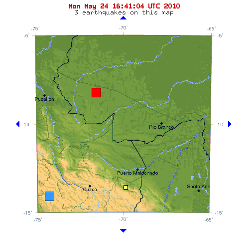
Earthquake Details
Magnitude 6.5
Date-Time Monday, May 24, 2010 at 16:18:29 UTC
Monday, May 24, 2010 at 11:18:29 AM at epicenter
Location 8.072°S, 71.569°W
Depth 580.5 km (360.7 miles)
Region ACRE, BRAZIL
Distances 127 km (79 miles) ESE (111°) from Cruzeiro do Sul, Brazil
328 km (204 miles) E (84°) from Pucallpa, Peru
464 km (288 miles) WNW (297°) from Rio Branco, Brazil
749 km (465 miles) NE (54°) from LIMA, Peru
Location Uncertainty horizontal +/- 5.4 km (3.4 miles); depth +/- 6.7 km (4.2 miles)
Parameters NST=326, Nph=326, Dmin=722.3 km, Rmss=0.87 sec, Gp= 29°,
M-type=teleseismic moment magnitude (Mw), Version=7
Source U.S. Geological Survey, National Earthquake Information Center:
World Data Center for Seismology, Denver
Event ID us2010wrbc
MAP: earthquake.usgs.gov...
and under the 6.5 is the 6.1 from sunday.
Originally posted by Anmarie96
6.5 2010/05/24 16:18:29 -8.072 -71.569 580.5 ACRE, BRAZIL
Wow thats pretty deep
not many felt responses though only 12 in 7 cities
earthquake.usgs.gov...
News Article with a bit of background on it
wireupdate.com...
[edit on 24-5-2010 by muzzy]
NZ overnight 3+ mag. More deep ones.
REF, LAT, LONG, DATE/TIME UTC, DEPTH, MAG, LOCATION
3312043, -41.60355, 173.35715, 2010/5/24 5:16:42.1, 113, 3.029, Wairau River, SW of Hillersden, Marlborough
3312114, -38.8853, 175.43999, 2010/5/24 8:34:47.9, 122, 3.276, E of Taumarunui, King Country
edit later: Some more
3312327, -41.36465, 172.98538, 2010/5/24 20:8:19.5, 121, 3.261, NW Wakefield, Nelson
3312517, -40.5719, 176.49931, 2010/5/25 3:46:13.0, 32, 3.175, o/s NE of Akito, Manawatu
[edit on 25-5-2010 by muzzy]
China - 5.0
Magnitude
5.0
Date-Time
Tuesday, May 25, 2010 at 06:11:54 UTC
Tuesday, May 25, 2010 at 02:11:54 PM at epicenter
Time of Earthquake in other Time Zones
Location
31.168°N, 103.553°E
Depth
22.8 km (14.2 miles)
Region
EASTERN SICHUAN, CHINA
Magnitude
5.0
Date-Time
Tuesday, May 25, 2010 at 06:11:54 UTC
Tuesday, May 25, 2010 at 02:11:54 PM at epicenter
Time of Earthquake in other Time Zones
Location
31.168°N, 103.553°E
Depth
22.8 km (14.2 miles)
Region
EASTERN SICHUAN, CHINA
reply to post by muzzy
Yah, there's a big thread going on right now because the quake showed up on pretty much every seismo in the world. People don't understand that it's because the quake was SO deep. I tried to explain, but speculation is still running wild.
Did you notice the 4.9 Fugi quake depth? 622 KM!!! I don't recall seeing them this deep this often. Do you?
I agree the depths are pretty dang crazy. I wouldn't even begin to know what it would mean even if it did start to become a trend.
Deep focus earthquake From Wikipedia, the free encyclopedia
A deep-focus earthquake is an earthquake that occurs at depths between 300 and 700 km beneath the Earth's surface.[1] Their cause is still not entirely understood since subducted lithosphere at that pressure and temperature regime should not exhibit brittle behavior. They are believed to be associated with mineralogical phase changes within the slab, such as olivine transforming into a more compact spinel structure. Deep focus earthquakes usually occur within subduction zones at oceanic-continental convergent boundaries.
Lots of big words there.
I read that other thread, funny how people panic over simple things.
Trying to find the deepest earthquake ever recorded.
Here we go
The deepest earthquake ever recorded is 705 km deep, under the Fiji Islands in the Southwest Pacific, on 6 May 2007.
my.opera.com...
earthquake.usgs.gov...
FILE CREATED: Tue May 25 07:54:18 2010
Global Search Earthquakes= 5736
Catalog Used: PDE
Date Range: 2000 to 2010
Depth Range: 500 - 800
Data Selection: Historical & Preliminary Data
FILE CREATED: Tue May 25 07:58:18 2010
Global Search Earthquakes= 3981
Catalog Used: PDE
Date Range: 1990 to 2000
Depth Range: 500 - 800
Data Selection: Historical & Preliminary Data
[edit on 25-5-2010 by berkeleygal]
reply to post by westcoast
Re the Fiji one.
They are relatively common along the Kermadec/Fiji islands subduction zone and the Vityaz Trench north east of Vanuatu.
Search of NEIC database for SW Pacific
590-700km deep
700-800km deep
[edit on 25-5-2010 by muzzy]
Re the Fiji one.
They are relatively common along the Kermadec/Fiji islands subduction zone and the Vityaz Trench north east of Vanuatu.
Search of NEIC database for SW Pacific
590-700km deep
700-800km deep
[edit on 25-5-2010 by muzzy]
Originally posted by Anmarie96
This one is odd and out of place
3.7 2010/05/24 07:27:06 33.386 -109.150 5.0 41 km ( 25 mi) NNE of Morenci, AZ
Magnitude
3.0
Date-Time
Tuesday, May 25, 2010 at 08:22:57 UTC
Tuesday, May 25, 2010 at 01:22:57 AM at epicenter
Time of Earthquake in other Time Zones
Location
33.273°N, 109.192°W
Depth
5 km (3.1 miles) set by location program
Region
ARIZONA
Distances
28 km (17 miles) NNE (21°) from Clifton, AZ
28 km (17 miles) NNE (27°) from Morenci, AZ
61 km (38 miles) N (352°) from Duncan, AZ
200 km (124 miles) NE (53°) from Tucson, AZ
639 km (397 miles) ESE (119°) from Las Vegas, NV
Same spot.
Will be interesting to see if any Iceland quake chatter after this...?
Magnitude 6.0 NORTHERN MID-ATLANTIC RIDGE
Date-Time
* Tuesday, May 25, 2010 at 10:09:06 UTC
* Tuesday, May 25, 2010 at 08:09:06 AM at epicenter
* Time of Earthquake in other Time Zones
Location 35.352°N, 35.925°W
Depth 10 km (6.2 miles) set by location program
Region NORTHERN MID-ATLANTIC RIDGE
Distances 625 km (385 miles) SW of Santa Cruz das Flores, Azores, Portugal
740 km (460 miles) WSW of Horta, Azores, Portugal
960 km (590 miles) WSW of Ponta Delgada, Azores, Portugal
2400 km (1490 miles) W of LISBON, Portugal
Interesting article - experts are saying Pacific Northwest to expect "big one" sooner rather than later.. “It is not a question of if a major
earthquake will strike, it is a matter of when. And the 'when' is looking like it may not be that far in the future,” the expert explains.
news.softpedia.com...
news.softpedia.com...
Am adding this one as it struck me as being in a location I haven't seen before on the 2.5+ list - at least I don't remember seeing it (which counts
for little!)
Magnitude 2.7 PUGET SOUND REGION, WASHINGTON
Date-Time
* Tuesday, May 25, 2010 at 12:21:00 UTC
* Tuesday, May 25, 2010 at 05:21:00 AM at epicenter
Location 47.680°N, 121.962°W
Depth 1.6 km (~1.0 mile) set by location program
Region PUGET SOUND REGION, WASHINGTON
Distances
* 4 km (2 miles) WSW (244°) from Lake Marcel-Stillwater, WA
* 5 km (3 miles) N (5°) from Ames Lake, WA
* 5 km (3 miles) NW (312°) from Carnation, WA
* 17 km (11 miles) ENE (58°) from Bellevue, WA
* 28 km (18 miles) ENE (78°) from Seattle, WA
reply to post by MoorfNZ
If you are starting from here
earthquake.usgs.gov...
click on the date /time (blue print link) part of the quake in question (not the map link) which will take you to
earthquake.usgs.gov...
then click on the Maps tag which takes you to
earthquake.usgs.gov...
then click on the Historical Siesmicity Map which take you to here
neic.usgs.gov...
its an active area.
[edit on 25-5-2010 by muzzy]
new topics
-
Gen Flynn's Sister and her cohort blow the whistle on DHS/CBP involvement in child trafficking.
Whistle Blowers and Leaked Documents: 2 hours ago -
Anybody else using Pomodoro time management technique?
General Chit Chat: 4 hours ago -
Bucks County commissioners vote to count illegal ballots in Pennsylvania recount
2024 Elections: 7 hours ago -
Trump sues media outlets -- 10 Billion Dollar lawsuit
US Political Madness: 8 hours ago -
Fired fema employee speaks.
US Political Madness: 8 hours ago -
How long till it starts
US Political Madness: 10 hours ago -
USSS Agent Fired for Having Sex In Michelle Obama's Bathroom
Politicians & People: 11 hours ago
top topics
-
Trump sues media outlets -- 10 Billion Dollar lawsuit
US Political Madness: 8 hours ago, 22 flags -
Bucks County commissioners vote to count illegal ballots in Pennsylvania recount
2024 Elections: 7 hours ago, 18 flags -
How long till it starts
US Political Madness: 10 hours ago, 16 flags -
Watching TV
Jokes, Puns, & Pranks: 14 hours ago, 9 flags -
USSS Agent Fired for Having Sex In Michelle Obama's Bathroom
Politicians & People: 11 hours ago, 9 flags -
Fired fema employee speaks.
US Political Madness: 8 hours ago, 9 flags -
Gen Flynn's Sister and her cohort blow the whistle on DHS/CBP involvement in child trafficking.
Whistle Blowers and Leaked Documents: 2 hours ago, 5 flags -
Anybody else using Pomodoro time management technique?
General Chit Chat: 4 hours ago, 3 flags
active topics
-
Trump sues media outlets -- 10 Billion Dollar lawsuit
US Political Madness • 41 • : Kaiju666 -
Trump picks Gov. Kristi Noem to serve as homeland security secretary
2024 Elections • 41 • : Solvedit -
Watching TV
Jokes, Puns, & Pranks • 2 • : texas thinker -
-@TH3WH17ERABB17- -Q- ---TIME TO SHOW THE WORLD--- -Part- --44--
Dissecting Disinformation • 3278 • : WeMustCare -
President-elect TRUMP Picks MATT GAETZ for his ATTORNEY GENERAL - High Level PANIC Ensues.
2024 Elections • 76 • : marg6043 -
How long till it starts
US Political Madness • 15 • : WeMustCare -
Post A Funny (T&C Friendly) Pic Part IV: The LOL awakens!
General Chit Chat • 7776 • : baddmove -
President-Elect DONALD TRUMP's 2nd-Term Administration Takes Shape.
Political Ideology • 201 • : WeMustCare -
Thune selected as Senate Republican Leader
US Political Madness • 77 • : yuppa -
Documenting the Second Failure of KAMALA HARRIS Attempting to Be U.S. President - 2024.
2024 Elections • 115 • : WeMustCare