It looks like you're using an Ad Blocker.
Please white-list or disable AboveTopSecret.com in your ad-blocking tool.
Thank you.
Some features of ATS will be disabled while you continue to use an ad-blocker.

FAA or 84RADES data falsified, or both.
page: 2share:
To clarify same of the errors the OP had discerned from the Flight Strips and to shed alittle more light on what to read from these strips.
The numbers that are reported to be headings are not headings, they are altitudes assigned to the flights. The first altitude of 17000ft is writtenas 170 followed by higher altitudes as they are issued etc...200, 260 (which) is the final cruise altitude. Headings are very rarely written on strips.
The number written with a decimal point 284.7 is an assigned frequency to switch the flight over to the next controller.
The third item the R on the strip indicates the flight was released for departure. Andrews AFB is controlled by the Potomac TRACON as the over lying radar facility. A tower such as Andrews needs to get approval to let the flight depart, or another word, get released. When this is accomplished the tower controller wioll write a letter R to indicate the release has been coordinated.
The other option for the R is that the flight was under Radar contact which is most likely the meaning of the R because this is a ARTCC strip.
I hope this clarified some of the Flight Progress Strip details.
Peace
[edit on 27-5-2009 by pale5218]
[edit on 27-5-2009 by pale5218]
Hey thanks for your very civil and professional input, pale5218. That is very helpful. I was hoping for your reply on an earlier (long-since
derailed) thread- I think it was a somewhat-recent UA93 thread in this subject group, but I'm guessing you are quite busy from your post count, so
you don't need to go looking for it. I don't have the direct link right now for you, but I have valued the few posts of yours that I have read.
I'm going to assume that you have/had something to do professionally affiliated with the FAA (but I'm not asking for any personal information or "sensitive" information here, and I DO NOT want you to give it out publicly- against forum rules, I think).
Thank you again.
I'm going to assume that you have/had something to do professionally affiliated with the FAA (but I'm not asking for any personal information or "sensitive" information here, and I DO NOT want you to give it out publicly- against forum rules, I think).
Thank you again.
Well Rhunter you have that correct. I still work for the FAA, going on 27 yrs and have worked a number of different places.
I do restrict what I write because sensitivity issues so I appreciate your concern. I do recall a thread a few weeks back reference Flight 93 but haven't seen it recently. If I get the chance, I'll look for it over the next few days.
Peace
I do restrict what I write because sensitivity issues so I appreciate your concern. I do recall a thread a few weeks back reference Flight 93 but haven't seen it recently. If I get the chance, I'll look for it over the next few days.
Peace
reply to post by rhunter
It is hilariously appropriate that you picked THIS thread to reply to my request for radar data to support your assertion that the "FAA" "NORAD" animation is supported by radar.
For other than the Form letters you've linked, you don't understand a darn thing you've posted. It is appropriately posted in a hilarious thread, which has vividly shown that the OP has no clue what he is hyperventilating about.
Let me save us both time as it's certainly not worth my time to continue
"pulling teeth". You have MADE NO POINT and you have not supported the assertion that the FAA radar data supports the animation used in another thread.
The last radar return from AA 77 on it's approach to the Pentagon was from DCA and the return was approximately abeam the Sheraton Hotel on it's known flight path toward the Pentagon. That return supports the FDR RO2 (readout) in terms of position. There are NO OTHER RADAR RETURNS from AA 77 to support the animation.
You can stop wasting time now as you have miserably FAILED.

Here's an update on that website that posted the FAA information from a purported FOIA release and court case.
s1.zetaboards.com...
Strange timing, with me posting that FAA RADAR data link here on that other thread...
s1.zetaboards.com...
AAL77.com has gone out of business.
Strange timing, with me posting that FAA RADAR data link here on that other thread...
reply to post by rhunter
The announcement was made two weeks ago, but regardless, it should be back up within a few days. If not, I have everything from that site stored on my hard drive and I will forward you a copy.
The announcement was made two weeks ago, but regardless, it should be back up within a few days. If not, I have everything from that site stored on my hard drive and I will forward you a copy.
Originally posted by Boone 870
reply to post by rhunter
The announcement was made two weeks ago, but regardless, it should be back up within a few days. If not, I have everything from that site stored on my hard drive and I will forward you a copy.
Hey Boone, you could help him out by sending him the data to support the FAA/NORAD animation for the final flight path of AA 77. He's really looking for that.
Otherwise, he might continue to be upset and falsely accuse me of lying.
reply to post by pale5218
This is a wise policy, pale. There are certain sects of the "truth movement" that have a habit of posting personal information of those they consider detractors, opponents, or enemies. If you upset their belief system, they will post any personal information about you that they can find. Just a forewarning.
Below is an image of an ADW Tower flight progress strip from the morning of September 11, 2001. In the far right-hand box, just above the filed flight route, someone has hand written "TL 270." What does TL 270 stand for, in your opinion?
[atsimg]http://files.abovetopsecret.com/images/member/c7163174c47e.jpg[/atsimg]
I do restrict what I write because sensitivity issues so I appreciate your concern.
This is a wise policy, pale. There are certain sects of the "truth movement" that have a habit of posting personal information of those they consider detractors, opponents, or enemies. If you upset their belief system, they will post any personal information about you that they can find. Just a forewarning.
Below is an image of an ADW Tower flight progress strip from the morning of September 11, 2001. In the far right-hand box, just above the filed flight route, someone has hand written "TL 270." What does TL 270 stand for, in your opinion?
[atsimg]http://files.abovetopsecret.com/images/member/c7163174c47e.jpg[/atsimg]
Sorry for the late response Boone. The TL270 on the strip is a heading. The reason it is written on the strip is it is a control instruction give from
a radar controller to a non-radar controller during a release.
In other words. ADW tower calls for a release of the IFR traffic, the radar controller will provide any instructions to the tower along with the release. In this case, the radar controller gave the tower "After departure TL heading 270." This is written on the strip because the individual in the tower who obtains the release may not be the one that clears the aircraft for takeoff. So the local controller (clearing the acft for takeoff) always reviews the strip when clearing IFR traffic for any control instructions given by the releasing radar controller.
I do want to emphasize that typically headings are not written on strips because they are too numerous. This is one of those occassions that their local operating procedures requires them to write it so the info is not lost during communication with several controllers.
I hope this cleared it up
[atsimg]http://files.abovetopsecret.com/images/member/c7163174c47e.jpg[/atsimg]
[atsimg]http://files.abovetopsecret.com/images/member/7904ae38c716.jpg[/atsimg]
Gee I wonder why the Gofer06 heading was not written TL235 since 270 is due west and as was actually flown by the C-130 as proven by videotaped and verified eyewitness testimony?
[atsimg]http://files.abovetopsecret.com/images/member/227343fb4a40.jpg[/atsimg]
And why are there no eyewitnesses to the C-130 far to the southwest of the Pentagon?
[atsimg]http://files.abovetopsecret.com/images/member/d0644214208f.jpg[/atsimg]
[edit on 6/4/09 by SPreston]
posted by pale5218
Sorry for the late response Boone. The TL270 on the strip is a heading.
[atsimg]http://files.abovetopsecret.com/images/member/7904ae38c716.jpg[/atsimg]
Gee I wonder why the Gofer06 heading was not written TL235 since 270 is due west and as was actually flown by the C-130 as proven by videotaped and verified eyewitness testimony?
[atsimg]http://files.abovetopsecret.com/images/member/227343fb4a40.jpg[/atsimg]
And why are there no eyewitnesses to the C-130 far to the southwest of the Pentagon?
[atsimg]http://files.abovetopsecret.com/images/member/d0644214208f.jpg[/atsimg]
[edit on 6/4/09 by SPreston]
Originally posted by SPreston
Gee I wonder why the Gofer06 heading was not written TL235 since 270 is due west and as was actually flown by the C-130 as proven by videotaped and verified eyewitness testimony?
Well now, you are absolutely correct about the 270 heading. In the future I expect there to be no argument about this then. It's settled once and for all. SPreston rises to the occasion again. What a shining example your expertise is to the "truth movement".
I think it's time for you to go into hiding for a few day again to allow the egg and slobber to clear from your face.
[edit on 4-6-2009 by Reheat]
This thread can now be closed. The OP has been proven wrong. The 84th RADES data is correct and the ATC transcripts are correct.
Furthermore, the CIT garbage has also been proven wrong as the C-130 flew the track as outlined in the 84th RADES data on the Camp Springs Departure essentially over the top of Reagan National Airport (KDCA).
Thanks to Boone, Pale, and SPreston for settling this issue once and for all....
Furthermore, the CIT garbage has also been proven wrong as the C-130 flew the track as outlined in the 84th RADES data on the Camp Springs Departure essentially over the top of Reagan National Airport (KDCA).
Thanks to Boone, Pale, and SPreston for settling this issue once and for all....
reply to post by Reheat
Well thank you Reheat. That was real good of you.
[atsimg]http://files.abovetopsecret.com/images/member/66d397449197.jpg[/atsimg]
Depart from Morningside 1 on Rwy 1L/1R and climb to 3000 at 010" and receive radar vectors at about 5 miles and turn left to 270" and fly west and parallel with and south of the Washington Mall. Just like it actually happened.
Congratulations Reheat. You finally got it and now you too can proclaim that the 84 RADES data was faked along with the fake Flight 77 loop southwest of the Pentagon which not one single person in all of Virginia witnessed anyway.
reply to post by Reheat
Gee Reheat. You've still got it wrong despite all the eyewitnesses and actual evidence and simple common sense? Even the FAA has the actual aircraft Over the Naval Annex and North of the Citgo rendering your disintegrating disinformation and propaganda impossible.
Come on Reheat; when are you going to face the music and admit that your precious pathetic 9-11 OFFICIAL STORY is self-destructing faster than your little bitty feet can keep up?
Become a patriotic American and seek justice for the innocent victims of the 9-11 perps. Soon even you will be able to look in a mirror without becoming nauseated.
reply to post by pale5218
Thanks for the clarification, pale. As you can see in the posts above, there is published standard departure procedure for all westbound aircraft departing out of Andrews Air Force Base.
CAMP SPRINGS ONE (PDF)
There are individuals in the "truth" community, including some "Professional Pilots," who believe that a C-130 was allowed to meander through Class B airspace, directly over DC near P-56, in spite of the published departure procedure.
[edit on 4-6-2009 by Boone 870]
Originally posted by Boone 870
There are individuals in the "truth" community, including some "Professional Pilots," who believe that a C-130 was allowed to meander through Class B airspace, directly over DC near P-56, in spite of the published departure procedure.
If you believe in the 9/11 Official Story, isnt that exactly what you have have to believe for a 757?
Although, I dont see any professional pilots claiming that a C-130 was "meandering" around DC. Do you have a direct quote?
reply to post by Reheat
Reheat, have you seen this LOA between PCT and Andrews Tower?
(page 9)
As you can see, aircraft with an assigned heading of 270° must pass south of Reagan. This directly contradicts the fantasy flight path that has the C-130 flying south of the mall and north of Reagan National. The "professionals" dismissed the LOA because it is dated June 2008, but I have found another document that indicates that the same procedures were used on 9/11:
Reheat, have you seen this LOA between PCT and Andrews Tower?
(page 9)
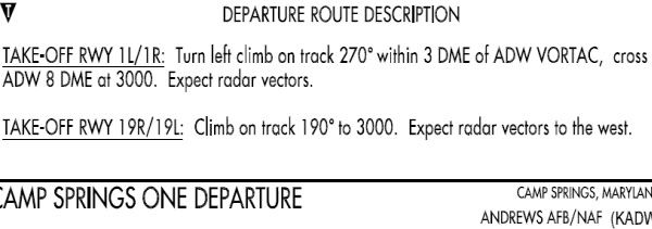
NOTE: Aircraft assigned a 270 heading shall be instructed by Tower to complete the turn within 3 DME of ADW VORTAC and cross the 180 radial of DCA VOR or a point 8 DME west of ADW VORTAC At 3,000 feet.
As you can see, aircraft with an assigned heading of 270° must pass south of Reagan. This directly contradicts the fantasy flight path that has the C-130 flying south of the mall and north of Reagan National. The "professionals" dismissed the LOA because it is dated June 2008, but I have found another document that indicates that the same procedures were used on 9/11:
Source
(Tape 7982 CIA, Ground Control) Word 31 verifies a turn to 270
at 3 DME after take off with, ironically, the following statement:
"Yeah, I don't want to get shot at today." [Note: A clear reference
to the requirement to stay out of P56 air space.]
Originally posted by Boone 870
reply to post by Reheat
Reheat, have you seen this LOA between PCT and Andrews Tower?
(page 9)
NOTE: Aircraft assigned a 270 heading shall be instructed by Tower to complete the turn within 3 DME of ADW VORTAC and cross the 180 radial of DCA VOR or a point 8 DME west of ADW VORTAC At 3,000 feet.
As you can see, aircraft with an assigned heading of 270° must pass south of Reagan. This directly contradicts the fantasy flight path that has the C-130 flying south of the mall and north of Reagan National. The "professionals" dismissed the LOA because it is dated June 2008, but I have found another document that indicates that the same procedures were used on 9/11:
Yes, I know. The only people they fool with their garbage is twoofers who will believe anything they say.
Only the ignorant buy the crap put out by CIT/Spreston and Co.
Anyone with even basic knowledge of departure procedures knows that an assigned departure heading applies immediately after Take-Off as soon as it's safe to turn.
The fact that Gopher 06 flew the Camp Springs Departure to the South of or approximately over DCA has been proven in multiple ways and it doesn't need to be proven again.
reply to post by AJ_Frost
I will try to find the actual quote later, but for now:
pilotsfor911truth.org...
(post #13)
Listen to the recordings made that day, you'll note that an aircraft not adhering to FAA flight rules gets alot of attention. I would expect the same thing if the C-130 was buzzing around near P-56 and not in communication with ATC.
If you believe in the 9/11 Official Story, isnt that exactly what you have have to believe for a 757?
Although, I dont see any professional pilots claiming that a C-130 was "meandering" around DC. Do you have a direct quote?
I will try to find the actual quote later, but for now:
pilotsfor911truth.org...
(post #13)
new topics
-
Paramilitary Leaks - John Williams
Whistle Blowers and Leaked Documents: 5 hours ago -
Some sausage, some chicken, some sauce, some onions and some garlic...and some peppers!
Food and Cooking: 6 hours ago -
Hearing more ambulances lately
Medical Issues & Conspiracies: 7 hours ago -
Los Angeles brush fires latest: 2 blazes threaten structures, prompt evacuations
Mainstream News: 7 hours ago -
House Passes Laken Riley Act
Mainstream News: 8 hours ago -
The more I think about it
General Chit Chat: 8 hours ago -
What Comes After January 20th
Mainstream News: 10 hours ago -
Canada as a state .. how would it work?
General Chit Chat: 10 hours ago -
Those stupid GRAVITE commercials
Rant: 11 hours ago
top topics
-
House Passes Laken Riley Act
Mainstream News: 8 hours ago, 23 flags -
What Comes After January 20th
Mainstream News: 10 hours ago, 18 flags -
Claim: General Mark Milley Approved Heat and Sound Directed Energy Weapons During 2020 Riots
Whistle Blowers and Leaked Documents: 16 hours ago, 12 flags -
Planned Civil War In Britain May Be Triggered Soon
Social Issues and Civil Unrest: 15 hours ago, 7 flags -
Let's Buy Greenland
General Chit Chat: 12 hours ago, 6 flags -
Those stupid GRAVITE commercials
Rant: 11 hours ago, 5 flags -
Hearing more ambulances lately
Medical Issues & Conspiracies: 7 hours ago, 5 flags -
Los Angeles brush fires latest: 2 blazes threaten structures, prompt evacuations
Mainstream News: 7 hours ago, 5 flags -
The more I think about it
General Chit Chat: 8 hours ago, 4 flags -
Canada as a state .. how would it work?
General Chit Chat: 10 hours ago, 4 flags
active topics
-
Los Angeles brush fires latest: 2 blazes threaten structures, prompt evacuations
Mainstream News • 12 • : Mantiss2021 -
Judge rules president-elect Donald Trump must be sentenced in 'hush money' trial
US Political Madness • 60 • : WeMustCare -
Planned Civil War In Britain May Be Triggered Soon
Social Issues and Civil Unrest • 14 • : WeMustCare -
Inca stone masonry at Sacsayhuaman, Ollantaytambo and the Sun Temple
Ancient & Lost Civilizations • 23 • : Hansllune -
Paradox of Progress
Ancient & Lost Civilizations • 14 • : Hansllune -
Let's talk planes.
General Chit Chat • 10 • : Dalamax -
Paramilitary Leaks - John Williams
Whistle Blowers and Leaked Documents • 8 • : caterpillage -
Claim: General Mark Milley Approved Heat and Sound Directed Energy Weapons During 2020 Riots
Whistle Blowers and Leaked Documents • 25 • : NoCorruptionAllowed -
Meta Llama local AI system is scary good
Science & Technology • 47 • : glend -
House Passes Laken Riley Act
Mainstream News • 15 • : KrustyKrab