It looks like you're using an Ad Blocker.
Please white-list or disable AboveTopSecret.com in your ad-blocking tool.
Thank you.
Some features of ATS will be disabled while you continue to use an ad-blocker.

Hurricane watch 2008
page: 5share:
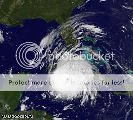
NEW ORLEANS, Louisiana (CNN) -- New Orleans Mayor Ray Nagin ordered a mandatory evacuation of the city beginning 8 a.m. Sunday but urged residents to consider escaping "the mother of all storms" before then.
"You need to be scared," Nagin said of the Category 4 hurricane tearing along Cuba's western coast. "You need to be concerned, and you need to get your butts moving out of New Orleans right now. This is the storm of the century."
The city's west bank is to evacuate at 8 a.m.
Nagin said the city had evacuated roughly 10,000 people Saturday on buses, trains and planes. Buses from collection points would continue running until midnight and resume at 6 a.m. Sunday, he said.

Mandatory evacuations to begin Sunday morning in New Orleans
Please visit the link provided for the complete story.
Gustav
Hanna
Our hopes and prayers go out to everyone affected by this.
Originally posted by LDragonFireOur hopes and prayers go out to everyone affected by this.
Indeed, and i hope that everybody will follow this advice:
You need to be concerned, and you need to get your butts moving out of New Orleans right now
From a person that lives 11 feet below sea level, Leave and live, it's as simple as that.
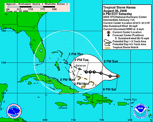
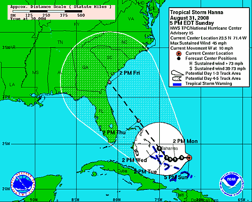
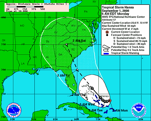
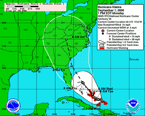
TS Hanna is being forecasted to become a hurricane in the next few days
as of 5pm, new warning were extended to cover the Central Bahamas.
www.nhc.noaa.gov...
another note from the 5pm advisory to keep in mind.
as of 5pm, new warning were extended to cover the Central Bahamas.
www.nhc.noaa.gov...
..TROPICAL STORM WARNING EXTENDED TO THE CENTRAL BAHAMAS...
AT 5 PM AST...2100 UTC...THE GOVERNMENT OF THE BAHAMAS HAS ISSUED A
TROPICAL STORM WARNING FOR THE CENTRAL BAHAMAS...INCLUDING CAT
ISLAND...THE EXUMAS...LONG ISLAND...RUM CAY...AND SAN SALVADOR.
A TROPICAL STORM WARNING REMAINS IN EFFECT FOR THE SOUTHEASTERN
BAHAMAS...INCLUDING THE ACKLINS...CROOKED ISLAND...THE
INAGUAS...MAYAGUANA...AND THE RAGGED ISLANDS.
A TROPICAL STORM WARNING IS ALSO IN EFFECT FOR ALL OF THE TURKS AND
CAICOS ISLANDS.
another note from the 5pm advisory to keep in mind.
TROPICAL STORM FORCE WINDS EXTEND OUTWARD UP TO 140 MILES...220 KM
FROM THE CENTER.
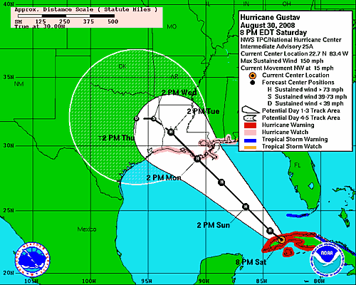
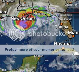
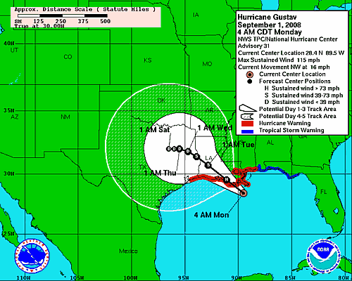
This is the updated projected path for Gustav:

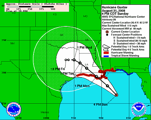
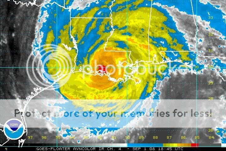
Reports from an Air Force Reserve hurricane hunter aircraft indicate maximum sustained winds have to decreased to near 115 mph ... with higher gusts.
… Some re-intensification is forecast during the next 12 to 24 hours and Gustav could regain Category Four strength later today or tonight. Fluctuations in strength are likely thereafter but Gustav is forecast to remain a major hurricane until landfall.
… an extremely dangerous storm surge of 12 to 16 feet above normal tidal levels is expected near and to the east of where the center of Gustav crosses the northern Gulf Coast. A storm surge of 1 to 3 feet above normal tide levels is possible in the Dry Tortugas as Gustav passes to its west.
Gustav is expected to produce total rainfall accumulations of 6 to 12 inches over portion of Louisiana[,] southern Mississippi and southern Arkansas with isolated maximum amounts of up to 20 inches possible through Wednesday morning. Additional rainfall amounts of about an inch are possible over Florida Keys and south Florida.
Latest advisory: Hurricane Gustav weakens, 'some re-intensification is forecast'
Please visit the link provided for the complete story.
Tropical Storm Hanna:
The September Hurricane season is roaring in like a lion. If you have not or are not going to evacuate, hang in there and If you can let us know whats going on.
I urge all affected to evacuate immediately.
I am with you friends, now work together to see everyone come thru this in light and health. May the winds blow peacefully upon your shores.

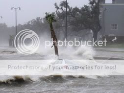
well ladies and gentleman Gustav has arrived
(CNN) -- Hurricane Gustav began to lash the southern Louisiana coastline early Monday as it moved closer to an expected midday landfall, according to the National Hurricane Center in Miami.
While forecasters said it could intensify a bit before moving inland, it will not likely be the Category 4 storm that had been predicted -- a possibility that added urgency to mass evacuation orders in recent days.
Nearly all of the roughly 2 million people in coastal Louisiana and the New Orleans area had cleared out ahead of Hurricane Gustav on Sunday night.
Road, rail and air links out of New Orleans began to close as the first storm bands began to strike the city. But more than 1.9 million people had fled New Orleans and its surrounding parishes by Sunday night, and fewer than 10,000 people were thought to remain in New Orleans, Louisiana Gov. Bobby Jindal said, citing the city's police chief.
Hundreds of thousands flee coastal Louisiana ahead of Gustav
Please visit the link provided for the complete story.
and some related news
NEW ORLEANS, Louisiana (CNN) -- Three years after Hurricane Katrina taught New Orleans' medical community some painful lessons, hospitals here are trying to learn from past mistakes.
At Tulane Medical Center, evacuations began early Sunday as a long line of ambulances took patients to the airport. From there, they were flown to hospitals outside the zone threatened by Gustav. Only the sickest patients will remain at the hospital.
During Katrina, 1,600 people sheltered at the Tulane hospital. This time, only 450 patients, staff and family members are expected to remain. Patients are allowed one family member to stay with them.

Hospitals use lessons from Katrina to prep for Gustav
Please visit the link provided for the complete story.
They are saying there are still up to 10,000 people still in the New Orleans area, good luck to those people.
(CNN) -- Hurricane Gustav began to lash the southern Louisiana coastline early Monday as it moved closer to an expected midday landfall, according to the National Hurricane Center in Miami.
While forecasters said it could intensify a bit before moving inland, it will not likely be the Category 4 storm that had been predicted -- a possibility that added urgency to mass evacuation orders in recent days.
Nearly all of the roughly 2 million people in coastal Louisiana and the New Orleans area had cleared out ahead of Hurricane Gustav on Sunday night.
Road, rail and air links out of New Orleans began to close as the first storm bands began to strike the city. But more than 1.9 million people had fled New Orleans and its surrounding parishes by Sunday night, and fewer than 10,000 people were thought to remain in New Orleans, Louisiana Gov. Bobby Jindal said, citing the city's police chief.
Hundreds of thousands flee coastal Louisiana ahead of Gustav
Please visit the link provided for the complete story.
and some related news
NEW ORLEANS, Louisiana (CNN) -- Three years after Hurricane Katrina taught New Orleans' medical community some painful lessons, hospitals here are trying to learn from past mistakes.
At Tulane Medical Center, evacuations began early Sunday as a long line of ambulances took patients to the airport. From there, they were flown to hospitals outside the zone threatened by Gustav. Only the sickest patients will remain at the hospital.
During Katrina, 1,600 people sheltered at the Tulane hospital. This time, only 450 patients, staff and family members are expected to remain. Patients are allowed one family member to stay with them.
Hospitals use lessons from Katrina to prep for Gustav
Please visit the link provided for the complete story.
They are saying there are still up to 10,000 people still in the New Orleans area, good luck to those people.
Ahhhhh!!!! Not only do we have a hurricane making landfall, Hanna is still expected to become at least a Cat 1 hurricane and threaten the S.E. coast
(i'm in the cone
We also have TD#9 which is currently heading west and at least 2 other areas of development to watch and waves yet to come off Africa.
www.nhc.noaa.gov...
Is there a sunspot going on? Increase of solar activity? ahhhh...it's only my nerves going....
(whoops forgot the link)
[edit on 9-1-2008 by worldwatcher]
ok here is the latest:
NEW ORLEANS, Louisiana (CNN) -- Hurricane Gustav swirled violently ashore Monday, turning lights out across the Gulf Coast and sending water over the tops of New Orleans' levees, officials said.
The storm's eastern bands, which generally pack the most powerful winds, also hammered Mississippi as Gustav moved to the west of New Orleans. Officials in Bay St. Louis, Pass Christian, Long Beach and Biloxi reported that Gustav was flooding U.S. Highway 90, making it impassable in parts.


Hundreds of thousands lose power as Gustav pounds coast
Please visit the link provided for the complete story.
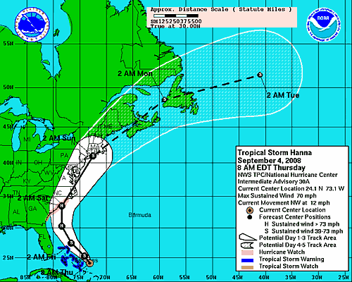
And here comes Hanna
PROVIDENCIALES, Turks and Caicos (AP) -- Hurricane Hanna formed Monday in the Atlantic, and hurricane warnings were issued for the central and southeastern Bahamas and Turks and Caicos Islands
Earlier Monday, Hanna brought battering waves, rain and blustery winds to the Turks and Caicos, closing the airport and schools and clearing the streets.
Forecasters said the storm, now a Category 1 hurricane, could come ashore in Georgia and South Carolina late in the week.
Hanna becomes hurricane in Atlantic
Please visit the link provided for the complete story.
Systems seem to be lining up in the Atlantic, September could be a record month for storms.
NEW ORLEANS, Louisiana (CNN) -- Hurricane Gustav swirled violently ashore Monday, turning lights out across the Gulf Coast and sending water over the tops of New Orleans' levees, officials said.
The storm's eastern bands, which generally pack the most powerful winds, also hammered Mississippi as Gustav moved to the west of New Orleans. Officials in Bay St. Louis, Pass Christian, Long Beach and Biloxi reported that Gustav was flooding U.S. Highway 90, making it impassable in parts.
Hundreds of thousands lose power as Gustav pounds coast
Please visit the link provided for the complete story.
And here comes Hanna
PROVIDENCIALES, Turks and Caicos (AP) -- Hurricane Hanna formed Monday in the Atlantic, and hurricane warnings were issued for the central and southeastern Bahamas and Turks and Caicos Islands
Earlier Monday, Hanna brought battering waves, rain and blustery winds to the Turks and Caicos, closing the airport and schools and clearing the streets.
Forecasters said the storm, now a Category 1 hurricane, could come ashore in Georgia and South Carolina late in the week.
Hanna becomes hurricane in Atlantic
Please visit the link provided for the complete story.
Systems seem to be lining up in the Atlantic, September could be a record month for storms.
Originally posted by worldwatcher
Ahhhhh!!!! Not only do we have a hurricane making landfall, Hanna is still expected to become at least a Cat 1 hurricane and threaten the S.E. coast (i'm in the cone
We've been 'in the cone' for the last two storms (Fay and Gustav) and ended up seeing very little activity at all. We're almost in Hanna's too! It's looking like she'll *most likely* make landfall in GA/SC though. :fingers crossed:
We also have TD#9 which is currently heading west and at least 2 other areas of development to watch and waves yet to come off Africa.
Read some speculation (somewhere) that TD#9 may take a similar track to Gustav's. Still way early, of course.
Is there a sunspot going on? Increase of solar activity? ahhhh...it's only my nerves going....
Strangely enough, no. In fact, as the Tropics have been in over-drive the last month or so, there's been no sunspots at all. [Sun Makes History: First Spotless Month in a Century]
(edit)FYI, I've been using this board for storm info. Several trackers, chasers and meteorologists like to post there.
[edit on 1-9-2008 by Rren]
We have Tropical Storm IKE now as of the 5pm update!!!
www.nhc.noaa.gov...
www.nhc.noaa.gov...
500 PM AST MON SEP 01 2008
...IKE...THE NINTH TROPICAL STORM OF THE SEASON...FORMS OVER THE
TROPICAL ATLANTIC...
AT 500 PM AST...2100Z...THE CENTER OF THE NEWLY FORMED TROPICAL
STORM IKE WAS LOCATED NEAR LATITUDE 17.7 NORTH...LONGITUDE 40.6
WEST OR ABOUT 1400 MILES...2250 KM...EAST OF THE LEEWARD ISLANDS.
Here in St Louis we have Tropical Depression Gustav Lots and Lots of rain here.
But the Atlantic is turning out one storm after another:
First we have Hanna:
Then we have Ike:
And now we have JOSEPHINE:
September is sure setting up to be a wild ride!
But the Atlantic is turning out one storm after another:
First we have Hanna:
Then we have Ike:
And now we have JOSEPHINE:
September is sure setting up to be a wild ride!

I mentioned this in another thread, but I'm very close to freaking out. I'm prepared and willing to deal with a Cat 1 or 2, but Ike is scaring me.
I'm in the cone and that black line seems to be pointing right at me. I'm not panicking yet, but I have to seriously consider evacuating depending
on the path. Right now I can only hope for the best and wait, perhaps we'll be spared again.
MIAMI, Florida (CNN) -- Hurricane Ike made landfall on the north coast of eastern Cuba Sunday as a Category 3 storm that weather experts were calling a "major hurricane."
The eye of the hurricane made landfall in the province of Holguin near Punto de Sama, with maximum winds near 125 mph.
Earlier Sunday, Ike hit Turks and Caicos Islands, leaving a trail of devastation. Rains and flooding from Ike also killed at least 73 people in Haiti.
"It pretty much looks like an episode of 'The Twilight Zone,' " said Audley Aftwood, a reporter for a radio station on Grand Turk Island. "It's like the end of the world."
Ike makes landfall in Cuba as Category 3 hurricane
Please visit the link provided for the complete story.
Another large hurricane approaching the gulf states area, this could be bad.
[edit on 8-9-2008 by LDragonFire]
(CNN) -- Mandatory evacuations were ordered in some Texas Gulf Coast counties Wednesday ahead of Hurricane Ike, which is expected to hit the coast Saturday.
The storm could swell to a dangerous Category 4 but is currently a Category 2 hurricane, forecasters said.
Ike forecast to be Category 4 hurricane at landfall
Please visit the link provided for the complete story.
This morning they were saying that Ike could hit Texas as a Cat. 3 hurricane, now they have upgraded that to Cat. 4
If your in the path of this storm, you really need to get out of this area.
new topics
-
Olive oil meta study
Diseases and Pandemics: 50 minutes ago -
Imam: 'In the Netherlands, Muslims Are in Charge
Social Issues and Civil Unrest: 1 hours ago -
Best water filter?
Health & Wellness: 4 hours ago -
Taxpayer Alert - I.R.S. Agents-Managers Officially Endorse KAMALA HARRIS for President.
2024 Elections: 8 hours ago -
Beetlejuice Beetlejuice
Movies: 8 hours ago -
Dozens of juveniles on bikes ransack Pico-Robertson 7-Eleven store for second time
Other Current Events: 9 hours ago -
Arizona Supreme Court says 98,000 People with Unconfirmed Citizenship Can Vote
2024 Elections: 11 hours ago
top topics
-
Taxpayer Alert - I.R.S. Agents-Managers Officially Endorse KAMALA HARRIS for President.
2024 Elections: 8 hours ago, 12 flags -
No more Kids .......
Social Issues and Civil Unrest: 12 hours ago, 11 flags -
Dozens of juveniles on bikes ransack Pico-Robertson 7-Eleven store for second time
Other Current Events: 9 hours ago, 9 flags -
Arizona Supreme Court says 98,000 People with Unconfirmed Citizenship Can Vote
2024 Elections: 11 hours ago, 8 flags -
Beetlejuice Beetlejuice
Movies: 8 hours ago, 4 flags -
Olive oil meta study
Diseases and Pandemics: 50 minutes ago, 2 flags -
Best water filter?
Health & Wellness: 4 hours ago, 1 flags -
Imam: 'In the Netherlands, Muslims Are in Charge
Social Issues and Civil Unrest: 1 hours ago, 1 flags
active topics
-
Dozens of juveniles on bikes ransack Pico-Robertson 7-Eleven store for second time
Other Current Events • 24 • : KrustyKrab -
Priests of the Temple of Syrinx
Social Issues and Civil Unrest • 37 • : KrustyKrab -
The Acronym Game .. Pt.4
General Chit Chat • 472 • : SecretKnowledge2 -
“Am I Racist?” - Matt Walsh Explodes DEI Grifters Minds
Movies • 13 • : gortex -
The iceberg that brought down the Titanic was a Russian spy
ATS Skunk Works • 34 • : SecretKnowledge2 -
How the U.S. Government is Failing to Protect Migrant Children from Trafficking and Abuse
Social Issues and Civil Unrest • 29 • : KrustyKrab -
Olive oil meta study
Diseases and Pandemics • 1 • : SprocketUK -
No more Kids .......
Social Issues and Civil Unrest • 28 • : yuppa -
Abnormal Society
Social Issues and Civil Unrest • 24 • : SprocketUK -
German Mainstream Media: Unvaccinated Declared Winners, Apologies Demanded from Government
Mainstream News • 50 • : PrivateAngel