It looks like you're using an Ad Blocker.
Please white-list or disable AboveTopSecret.com in your ad-blocking tool.
Thank you.
Some features of ATS will be disabled while you continue to use an ad-blocker.
share:
Originally posted by Razimus
spikedmilk This quote removed for offensive nature by NGC2736
[edit on 1-2-2008 by elevatedone]
reply to post by spikedmilk
OMG your right!you have single handedly proved the existence of E.T's! you have brought world religions crashing down!All over some shadows!while i like the post, you are makeing some pretty big leaps, more than pretty big,more like huge leaps!
OMG your right!you have single handedly proved the existence of E.T's! you have brought world religions crashing down!All over some shadows!while i like the post, you are makeing some pretty big leaps, more than pretty big,more like huge leaps!
Originally posted by Pro-genetic
reply to post by spikedmilk
OMG your right!you have single handedly proved the existence of E.T's! you have brought world religions crashing down!All over some shadows!while i like the post, you are makeing some pretty big leaps, more than pretty big,more like huge leaps!
nah, You give me way too much credit. I just posted a couple pics of a bunch of rocks and shadows and such. The 'such' I personally felt broke the norm of those rocks and shadows. Didntya know? Well at least I'm glad ya like the post. Sure smells like smarcasm this morn, what dya think?
Thanks for looking though........
spikeD.
reply to post by spikedmilk
no prob, There was a slight hint of sarcasim alright,i just couldn help it!
Also a slight hint of a one liner.------NGC2736,Forum Moderator.
Touché Mister Mod
[edit on 31-1-2008 by NGC2736]
[edit on 31-1-2008 by Pro-genetic]
Mod Note : We don't edit MOD EDITS.... Thank You.
[edit on 1-2-2008 by elevatedone]
Hi there, (OP)
Recently, we saw the Martian Bigfoot and the "door", now the Castles, what's next ?
Martian Mickey Mouse ?
Peace,
Europa
Recently, we saw the Martian Bigfoot and the "door", now the Castles, what's next ?
Martian Mickey Mouse ?
Peace,
Europa
When Spikedmilk asked me what was my take about some of these pics, i've said that one of them recalled me vaguely the "castle" on the Moon:

So if you feel the need to attack someone for having chosen that name,
feel free to attack me.
But maybe is better to choose one of the following options:
a) Comment the images.
b) Do not post at all.
Peace,
Internos

So if you feel the need to attack someone for having chosen that name,
feel free to attack me.
But maybe is better to choose one of the following options:
a) Comment the images.
b) Do not post at all.
Peace,
Internos
Gang... I will post sans sarcasm. I see nothing that resembles that which you are referring to. I see variations in the martian landscape due to
normal geologic formations and shadows. The world is going to need much clearer photos with highly defined shapes in order to ever accept such
outlandish theories. Got any?
Click here for more information.
The posting of such pictures is against the T&C
NGC2736
Forum Moderator
[edit on 31-1-2008 by NGC2736]
Saw a couple of your interpretations and, unfortunately was not very impressed. I did discern some, but not all. I would definitely ask all to keep
looking, as sooner or later one of you rock hounds will find the payday we're (even the skeptics, or even they wouldn't be on this site) all
searching for. One of the things I found amazing was the obvious shorelines. As others have said before, I'm no reader of such, but it does look as
though the water just "dissappeared". Yeah?
Sorry, but i don't need you to know what is pareidolia, and by the way don't you have a better source than wikipedia or was it just to make me
laugh?
Anyway, you made exactly my point: if you think that there's nothing to comment, why do you post anyway? Mmmhhh?
Peace,
Internos
[edit on 31/1/2008 by internos]
Anyway, you made exactly my point: if you think that there's nothing to comment, why do you post anyway? Mmmhhh?
Peace,
Internos
[edit on 31/1/2008 by internos]
As May be noted, I have done some housecleaning on this thread.
I suggest that comments and pictures have something of value to add to this thread. Juvenile posts do not further the thread.
I'll allow mild sarcasm, but there are limits there.
Folks, let's post with civility in mind and stay on topic.
I suggest that comments and pictures have something of value to add to this thread. Juvenile posts do not further the thread.
I'll allow mild sarcasm, but there are limits there.
Folks, let's post with civility in mind and stay on topic.
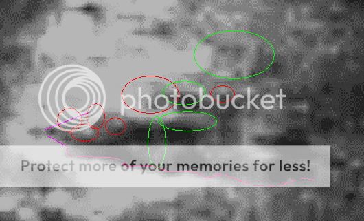
Alright, I have been messing around trying to draw lines on this thing, and I just am not satisified. So I thought I would circle what I felt in my
opinion, were the most prominent features on this 'thing'.
The red circles are for the round features. I didnt bother with ones closest to the ground...no explanation necessary I'm sure. The green circles are for the features that were straight in appearance. At the most western end notice the conical shape, highlighted by the dark purple, and where the object is meeting the surface/ground, highlighted in light purple.
"Clean" version on the bottom for comparison.


[edit on 31-1-2008 by spikedmilk]
The red circles are for the round features. I didnt bother with ones closest to the ground...no explanation necessary I'm sure. The green circles are for the features that were straight in appearance. At the most western end notice the conical shape, highlighted by the dark purple, and where the object is meeting the surface/ground, highlighted in light purple.
"Clean" version on the bottom for comparison.


[edit on 31-1-2008 by spikedmilk]
reply to post by internos
Welcome back my friend! Its been awhile since we've seen you on these boards. We await your full return . And welcome to the 'party', I hope you enjoy it, though it doesnt seem like anyones having a good time and nobody's touched the kool-aid yet .
Welcome back my friend! Its been awhile since we've seen you on these boards. We await your full return . And welcome to the 'party', I hope you enjoy it, though it doesnt seem like anyones having a good time and nobody's touched the kool-aid yet .
reply to post by NGC2736
Hi there,
You got to be kidding me...
Since when is it improper to post pictures of animals ?
The exemple I used with the dog's butt was really good. If only you saw pornographic material I could understand but a dog !!!
You got me for a while with this one.
Peace,
Europa
Hi there,
You got to be kidding me...
Since when is it improper to post pictures of animals ?
The exemple I used with the dog's butt was really good. If only you saw pornographic material I could understand but a dog !!!
You got me for a while with this one.
Peace,
Europa
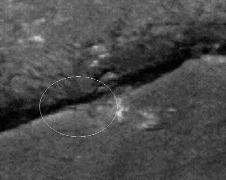
So, maybe for the time being we'll move on and return to the 'castle' later. For now I bring to your attention a couple of square edges protruding
out of the Martian ground from the area I dubbed the 'northshore'. Remember, I mentioned this area looked like one big dried up river bed.....
These just cant be dismissed as rocks and shadows can they?

www.msss.com...
These just cant be dismissed as rocks and shadows can they?

www.msss.com...
I'm sorry, but until we get crystal clear images i can probably make out my dog's name on the surface somewhere if i squint good, i'm sorry to be
negative but that's the way i feel about it.
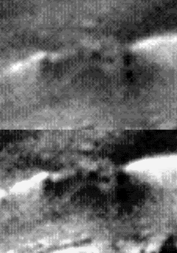
And from the 'southern' shoreline, we have the sand castle. Raw image on top, enhanced for comparison on the bottom........Its just a name folks.

www.msss.com...

www.msss.com...
reply to post by spikedmilk
That last one looks good.
Maybe some one else can make an opinion of it.
That last one looks good.
Maybe some one else can make an opinion of it.
It took me some time to see the areas you marked in the original photo. One of the reasons was that I did not knew if you had used the map-projected
or the non map-projected version.
As you call "Southern shoreline" to a feature that is to the North, I suppose you used the non map-projected image.
In that image the Sun light is coming from the bottom right corner of the image (50.62° clockwise from a line drawn from the centre to the right edge of the image to the direction of the sun at the time the image was acquired), and that may help distinguish a mesa from a ravine.
Your first image, for example shows a mesa, the "fallen castle" being on one of the mesa's sides.
I downloaded the original, non map-projected IMG file, opened it in The Gimp (version 2.2.16 has a plug-in to open those IMG files), applied the "Destripe" filter and changed the levels. After that I resized to 300%.
This is the result.

To me, the "fallen castle" looks just like common vertical ridges on a slope (I hope you understand what I want to say, sometimes I can not find the right words).
Here it is, rotated and resized to 200% from the previous image.

The "terrace" looks like anything, really, I don't see anything out of ordinary here.

The "archway" looks like the shadow of the higher rocks.

The "sand castle" does not look that strange in a picture with more shades of grey.

The "shoreline" does not look that strange if you are accustomed to higher definition images from Mars.

In this image I don't know what it is that you call "the entrance". Is it that dark area? That is the shadow of the side of that small crater.

In the last image I don't see anything unusual.

I would like to ask one thing: why do almost all your images have such a low colour count? There is one (the one with the "sand castle", that has only 14 shades of grey! How do you suppose to see anything in an image like that, that has lost most of its data?
As you call "Southern shoreline" to a feature that is to the North, I suppose you used the non map-projected image.
In that image the Sun light is coming from the bottom right corner of the image (50.62° clockwise from a line drawn from the centre to the right edge of the image to the direction of the sun at the time the image was acquired), and that may help distinguish a mesa from a ravine.
Your first image, for example shows a mesa, the "fallen castle" being on one of the mesa's sides.
I downloaded the original, non map-projected IMG file, opened it in The Gimp (version 2.2.16 has a plug-in to open those IMG files), applied the "Destripe" filter and changed the levels. After that I resized to 300%.
This is the result.

To me, the "fallen castle" looks just like common vertical ridges on a slope (I hope you understand what I want to say, sometimes I can not find the right words).
Here it is, rotated and resized to 200% from the previous image.

The "terrace" looks like anything, really, I don't see anything out of ordinary here.

The "archway" looks like the shadow of the higher rocks.

The "sand castle" does not look that strange in a picture with more shades of grey.

The "shoreline" does not look that strange if you are accustomed to higher definition images from Mars.

In this image I don't know what it is that you call "the entrance". Is it that dark area? That is the shadow of the side of that small crater.

In the last image I don't see anything unusual.

I would like to ask one thing: why do almost all your images have such a low colour count? There is one (the one with the "sand castle", that has only 14 shades of grey! How do you suppose to see anything in an image like that, that has lost most of its data?
new topics
-
U.S. Government Agencies That Protect Criminals in Government - National Archives Records Admin-NARA
Political Conspiracies: 53 minutes ago -
Trump says ownership of Greenland 'is an absolute necessity'
Other Current Events: 2 hours ago -
An Updated China Navy Analysis and the Challenges of their AI/Drone Development
Military Projects: 4 hours ago -
University looking for gender diverse kids to play with transgender dolls for research
Social Issues and Civil Unrest: 4 hours ago -
FAA Investigates Christmas Drone Show Gone Wrong in Orlando, FL 12/2024
Other Current Events: 4 hours ago -
Mass Extinctions May Hold the Key to Life in the Universe
Education and Media: 8 hours ago -
Can we be certain that Jesus Christ was born on December 25th?
Religion, Faith, And Theology: 10 hours ago
top topics
-
University looking for gender diverse kids to play with transgender dolls for research
Social Issues and Civil Unrest: 4 hours ago, 8 flags -
RIP Merrily Harpur British Big Cat Realist
Cryptozoology: 12 hours ago, 7 flags -
Can we be certain that Jesus Christ was born on December 25th?
Religion, Faith, And Theology: 10 hours ago, 4 flags -
Mass Extinctions May Hold the Key to Life in the Universe
Education and Media: 8 hours ago, 4 flags -
FAA Investigates Christmas Drone Show Gone Wrong in Orlando, FL 12/2024
Other Current Events: 4 hours ago, 4 flags -
An Updated China Navy Analysis and the Challenges of their AI/Drone Development
Military Projects: 4 hours ago, 3 flags -
Trump says ownership of Greenland 'is an absolute necessity'
Other Current Events: 2 hours ago, 3 flags -
U.S. Government Agencies That Protect Criminals in Government - National Archives Records Admin-NARA
Political Conspiracies: 53 minutes ago, 1 flags
active topics
-
An Interesting Conversation with ChatGPT
Science & Technology • 35 • : DdPoolDude -
Trump says ownership of Greenland 'is an absolute necessity'
Other Current Events • 3 • : BingoMcGoof -
NYPD arrests migrant who allegedly set woman on fire on subway train, watched her burn to death
Breaking Alternative News • 30 • : matafuchs -
U.S. Government Agencies That Protect Criminals in Government - National Archives Records Admin-NARA
Political Conspiracies • 0 • : WeMustCare -
University looking for gender diverse kids to play with transgender dolls for research
Social Issues and Civil Unrest • 18 • : Tolkien -
My personal experiences and understanding of orbs
Aliens and UFOs • 26 • : Compendium -
Australian mercenary caught and crying as he is a prisoner of war.
Other Current Events • 37 • : Cavemannick -
FAA Investigates Christmas Drone Show Gone Wrong in Orlando, FL 12/2024
Other Current Events • 9 • : KrustyKrab -
Why isn't Psychiatry involved?
Social Issues and Civil Unrest • 34 • : GENERAL EYES -
Mood Music Part VI
Music • 3757 • : angelchemuel

