It looks like you're using an Ad Blocker.
Please white-list or disable AboveTopSecret.com in your ad-blocking tool.
Thank you.
Some features of ATS will be disabled while you continue to use an ad-blocker.
share:
Originally posted by Damocles
somewhere in a closet i believe i still have, or at least can get, one of the books i used to use to plot downwind hazards for fallout. if i have one, all i will need would be measurements of the cloud (height/width as observed from somewhere we can verify) and a weather report from that day.
So what exact parameters are you looking for from that day, and how do you know they're isolated from the effects of any other variables?
well, we would need to know the position of the photographer (cuz all we have to go on is photographs) so that we can determine the height and width
of the cloud. we also need to know exactly when the photo was taken as the cloud change over time affects the variables.
then we need an accurate weather report for the location at the time to photo was taken.
and yes, this would give us yeild of an open air device. but, we KNOW that the yeild of an open air device would be LESS than one detonated under the building (or in it, where ever the theory's place it) so then we KNOW that if we get a yeild of X kt and that the building would absorb some of the blast then the ACTUAL device would have been greater than X, we're on the path. becuase if X is too large to have been viable then anything greater than X is out of the question, yes?
it would just give us something to think about as to whether or not a nuclear device is plausable.
or am i the only one that this makes sense to?
What I meant was, how do you know if detonation inside one of these buildings would have increased or decreased the size of the cloud as opposed to
the same thing going off in open air? How do you separate the actual cloud and the debris being blown out, and the material it's giving off, and
all the concrete dust?
well thats why you wouldnt use the cloud sizes at detonation+10 seconds. you can actually calculate based on the cloud for some time after the blast
cuz there were guys working on these algorithms for years and years during they heyday of cold war nuclear testing.
so in "theory" all of the heavy debris has already hit the ground and youre basing off residuals.
id be happy to try to work it out from the cloud at collapse+10 mins or so.
so in "theory" all of the heavy debris has already hit the ground and youre basing off residuals.
id be happy to try to work it out from the cloud at collapse+10 mins or so.
Think about this.... A modern ballistic nuclear missle carries not just one nuclear warhead but many warheads , or MIRV's (Multiple Independent
Re-Entry Vehicle). I know these missles are quite large but even so they are mostly fuel tanks and I guarantee you those warheads are no larger than
your computer monitor or more likely even a basketball, and these are something like 200 kiloton weapons EACH. Military science was nuke crazy in the
50's and 60's ,there were nuclear rounds made for even small artillery pieces. I even remember reading somewhere about a stupid attempt to make a
nuclear hand grenade that was scrapped because no one could possibly throw it far enough, not that it could not be made. Do not be ignorant enough to
believe that no one is capable of producing tiny directional nuclear weapons by 2001 when the technology existed to make a nuclear hand grenade nearly
50 years ago. Logistically, nuclear weapons are the simplest way the towers could have been destroyed. What else would expain the core spire that
stood for some seconds after the collapse only to evaporate into dust for all to see?
I think that conventional thermate and thermite cutting charges were used at the top just under the damage done by the "plane".
As these conventional charges began the toppling of the tower, that began to lean, say three to five seconds, the thermonuclear nuclear hydrogen device of say 0.01-0.05 Kt yield was detonated in the basement under the support columns in the center.
As these conventional charges began the toppling of the tower, that began to lean, say three to five seconds, the thermonuclear nuclear hydrogen device of say 0.01-0.05 Kt yield was detonated in the basement under the support columns in the center.
Deagle is a nutjob. Like Icke and Michael Tsariou, he mixes in enough truth and revelation to keep you interested then digresses to his real agenda
and message of lies..
[edit on 25-8-2008 by Nonchalant]
[edit on 25-8-2008 by Nonchalant]
I have not read all the posts and did see some of my unreferenced information in the responses. Thank you above top secret and the poster of the
original thread. The information presented by Deagle was my research of an entire year - 12 to 18 hours a day.
Anyway my main articles on on WMDs in the WTC are here:
www.thepriceofliberty.org... and here:
www.thepriceofliberty.org...
There are over 200 referenced facts used in just these 2 articles, over 300 in my series of articles over the year period.
Google "Ed Ward, MD" and just about any aspect of the WTC with my name to find referenced facts on the topic. ie, tritium, dilution, nuke, jones, DEW, thermate.
According to Jeff Rense, Bill Deagle and my semi humble self - I am the foremost expert on the WTC evidence/false flag operation.
My Best to You and Yours,
Ed
Yes, I too wondered about Nukes being used, since in the 70's thats what they claimed would distroy NYC, and that was from a Nostradomus movie...
go to google video and type in The New Hiroshima ... dr Judy Woods.
go to google video and type in The New Hiroshima ... dr Judy Woods.
I have not read all the posts and did see some of my unreferenced information in the responses. Thank you above top secret and the poster of the
original thread. The information presented by Deagle was my research of an entire year - 12 to 18 hours a day.
Anyway my main articles on on WMDs in the WTC are here:
www.thepriceofliberty.org... and here:
www.thepriceofliberty.org...
Deagle's perception of my referenced facts regarding the massive tritium www.thepriceofliberty.org...
There are over 200 referenced facts used in just these 2 articles, over 300 in my series of articles over the year period.
Google "Ed Ward, MD" and just about any aspect of the WTC with my name to find referenced facts on the topic. ie, tritium, dilution, nuke, jones, DEW, thermate.
According to Jeff Rense, Bill Deagle and my semi humble self - I am the foremost expert on the WTC evidence/false flag operation.
My Best to You and Yours,
Ed
[edit on 4-2-2009 by EdWardMD]
[edit on 4-2-2009 by EdWardMD]
reply to post by BornPatriot
ROFL, Dr Judy Wood - Head of the BYU crew of mormons doing everthing in their power to keep the NUKE finger from being pointed at Israel. Mormons = better than israelites and better than christians = the most of the more equals and a HUGE percentage of the CIA scumbags.
She can't even find which DEW supposedly did it, lasers, microwaves, tesla, hutchinsons and a couple more are all proclaimed as misdirection without stating what exactly was used and without a single one that could possibly be responsible for ALL THE EVIDENCE. Even in combination the DEWS could not do what was clearly done by several Dimona nukes fresh out of Israel is the most likely scenerio and all the scam BYU crew, including the Jones twins ARE DESPERATE TO HIDE THE NUKE ISRAELI CONNECTION.
DrEd
And finally a correction to the main post. There was no nuke used on 7 - the hot spot at 7 was probably from debris from 1 and 2, there was at least
one nuke used in 1, 2 (probably at least 2 in these) and 6.
DrEd
DrEd
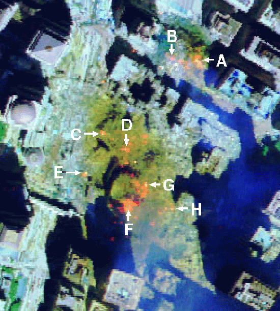
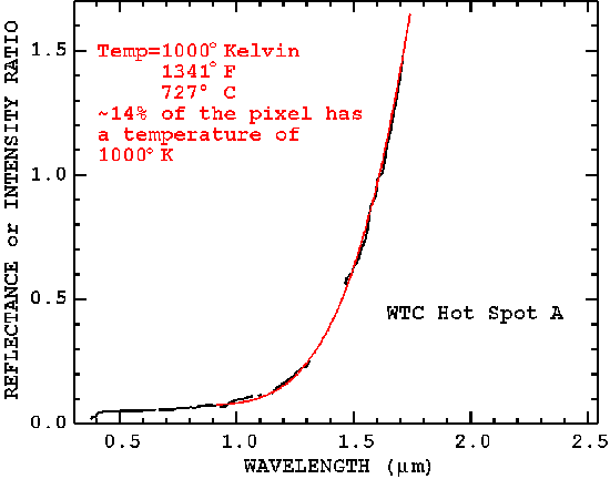
Interesting. An explanation for the hotspots lasting for weeks beneath the WTC?
And here we have the images of the spire from WTC2 mysteriously turning into dust.

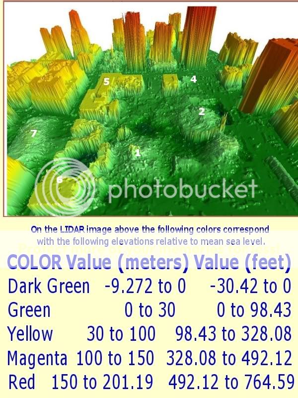
NOAA LIDAR from the west
Light Detection and Ranging - LIDAR displays from NOAA - Dark Green = 0 to -30 feet.
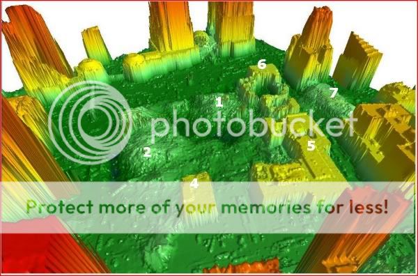
NOAA LIDAR 3 from the east
Light Detection and Ranging - LIDAR displays from NOAA - Dark Green = 0 to -30 feet.
Building 6 hole 30 to 55 feet below ground level
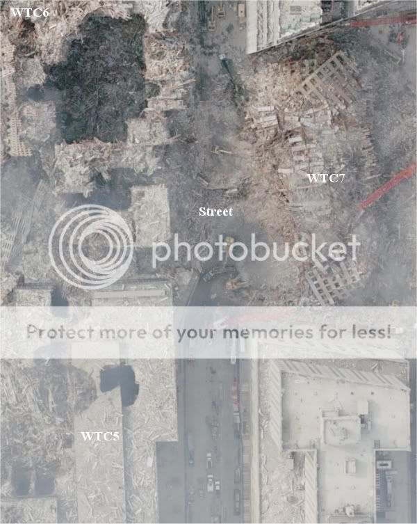
NOAA LIDAR 2 unzoom from the west
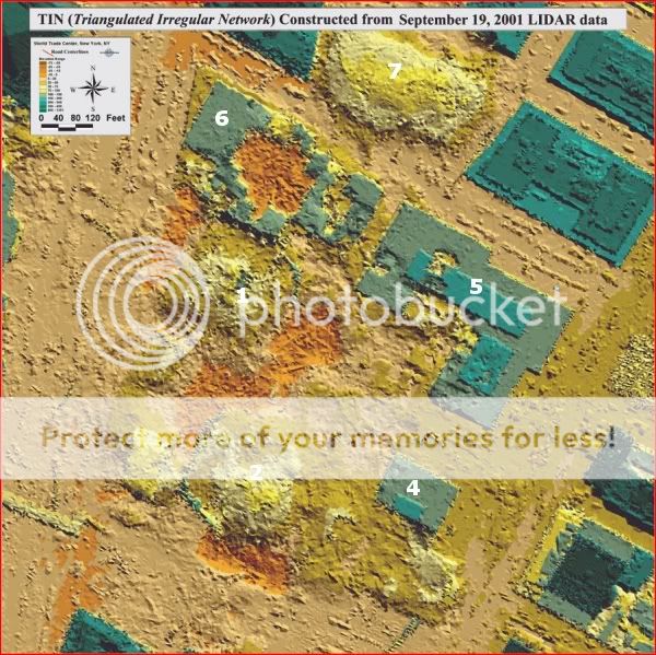
TIN (Triangulated Irregular Network)
[edit on 2/4/09 by SPreston]


And here we have the images of the spire from WTC2 mysteriously turning into dust.

NOAA LIDAR from the west
Light Detection and Ranging - LIDAR displays from NOAA - Dark Green = 0 to -30 feet.

NOAA LIDAR 3 from the east
Light Detection and Ranging - LIDAR displays from NOAA - Dark Green = 0 to -30 feet.

Building 6 hole 30 to 55 feet below ground level

NOAA LIDAR 2 unzoom from the west
Digital Surface Models created by the LIDAR system provide very accurate 3-dimensional positioning of the building structures and the surrounding area. The 3-D models, in this case, have helped to locate original support structures, stairwells, elevator shafts, basements, etc. When this data is merged with the high resolution aerial photography taken by NOAA's Citation aircraft, it will create a very accurate image with relative accuracy around three decimeters.
This was a partnership between NOAA, Army Joint Precision Strike Demonstration, Optech Inc. of Toronto, Canada, and the University of Florida. Optech and the University of Florida processed the data which produced the image.
TIN (Triangulated Irregular Network)

[edit on 2/4/09 by SPreston]
IF a micro nuke there still should be "micro" traces of radiation from the blast....where is the evidence?
reply to post by SPreston
Thanks for posting some of the picture references in my second article - March 2007. There are several more in the article. www.thepriceofliberty.org...
DrEd
Thanks for posting some of the picture references in my second article - March 2007. There are several more in the article. www.thepriceofliberty.org...
DrEd
reply to post by Anonymous ATS
Got a reference for this BS statement that clearly shows you don't even know the basic concepts of 1st (years) and 4th generation nukes in which radiation is measured in hours/days - IN THE ARTICLE IF YOU HAD BOTHERED TO READ IT, but nice to see you didn't let that bother you from posting BS.
DrEd
Got a reference for this BS statement that clearly shows you don't even know the basic concepts of 1st (years) and 4th generation nukes in which radiation is measured in hours/days - IN THE ARTICLE IF YOU HAD BOTHERED TO READ IT, but nice to see you didn't let that bother you from posting BS.
DrEd
Now that I have addressed one completely unfactual if and should, I have no intention of answering every completely ignorant of the facts poster that
hasn't even read the article then makes a BS UNREFERENCED statement then accepts it as fact and ask a BS question as proof there needs to be more
facts. There are more than 300 references in my articles, I'll be glad to respond to any legitimate questions from people that have REFERENCES THAT
COUNTER ANY OF MY REFERENCES OR HAVE REFERENCES THAT COUNTER ANY OF THE PROOFS THAT CLEARLY SHOW A NUKE WAS USED. Like these that the BYU crew are
still trying to ignore/hide.
Joneses, 911 'Truth' Still Silent
On Proven 'Anomalies'?
By Ed Ward, MD
1-26-8
Will the Joneses and 911 'Truth' Orgs Ever Legitimately Address the Referenced, Verifiable, Proven Facts that Are, In Total, Only Consistent With Micro ThermoNuclear Usage and which Have Never Been Noted
or Addressed on a Scientific Level?
Steven Jones, Alex Jones, 911 'Truthers' Orgs, Still Seem to Be Denying, Misrepresenting and Doing Their Best to Ignore the Following Facts and More. Why? This is a profound and crucial question.
Steven Jones, Alex Jones, and 911 'Truth' Organizations all seem to be denying, misrepresenting, and doing their best to hide:
www.rense.com...
DrEd
reply to post by EdWardMD
I'm not sure exactly how compliments from Jeff Rense and Bill Deagle put you any further along on the credibility scale, but we'll just table
that for the time being.
I'll spend some time over the next few weeks reviewing your information. I have to admit I'm a little hesitant given the need to respond with "BS" or "you're too stupid to get it" or something to similar effect.
The fact that your website isn't plastered with PayPal donation buttons, you're not pushing a new book and there's no CafePress store are all points in your favor.
Who knows. If your research is a thorough as you claim and still indicates what you are positing then it'd be a welcome first.
As a side note, have you done any investigation into the procurement and placement of such devices? I'm not asking for supposition, just asking if you have any definitive facts in those regards.
It'll take a while to fully digest your material. I'm sure you'll understand if it takes some time to pose some questions.
Does this guy claim that steel was vaporized too?
In another thread, I did a calc that showed to vaporize just 10,000 tons (IIRC) of core steel, giving them EVERY point that they claimed would decrease blast effects, etc....
The resultant blast effects would still be on the order of 20tons (IIRC) of TNT equivalent. Total energy release was several times that.
Clearly, this didn't happen.
new topics
-
Thanksgiving 2024
Member Art: 4 hours ago -
The art of being offended
Social Issues and Civil Unrest: 6 hours ago -
FLORIDA Sues Biden-Harris FEMA for Denying Disaster Assistance to Homeowners with TRUMP Signs.
US Political Madness: 7 hours ago -
Turns out, they planned to go after P-nut.
US Political Madness: 11 hours ago
top topics
-
Turns out, they planned to go after P-nut.
US Political Madness: 11 hours ago, 20 flags -
The art of being offended
Social Issues and Civil Unrest: 6 hours ago, 17 flags -
FLORIDA Sues Biden-Harris FEMA for Denying Disaster Assistance to Homeowners with TRUMP Signs.
US Political Madness: 7 hours ago, 13 flags -
Thanksgiving 2024
Member Art: 4 hours ago, 9 flags -
Sick sick sick ---graphic story
Social Issues and Civil Unrest: 17 hours ago, 7 flags
active topics
-
Mike Tyson returns 11-15-24
World Sports • 23 • : argentus -
President-elect TRUMP Picks MATT GAETZ for his ATTORNEY GENERAL - High Level PANIC Ensues.
2024 Elections • 64 • : WeMustCare -
The art of being offended
Social Issues and Civil Unrest • 24 • : argentus -
Thanksgiving 2024
Member Art • 10 • : Lumenari -
FLORIDA Sues Biden-Harris FEMA for Denying Disaster Assistance to Homeowners with TRUMP Signs.
US Political Madness • 30 • : Lumenari -
President-Elect DONALD TRUMP's 2nd-Term Administration Takes Shape.
Political Ideology • 183 • : WeMustCare -
Encouraging News Media to be MAGA-PAF Should Be a Top Priority for Trump Admin 2025-2029.
Education and Media • 68 • : WeMustCare -
The Trump effect 6 days after 2024 election
2024 Elections • 113 • : cherokeetroy -
WATCH LIVE: US Congress hearing on UFOs, unidentified anomalous phenomena
Aliens and UFOs • 52 • : putnam6 -
The Acronym Game .. Pt.4
General Chit Chat • 952 • : JJproductions
