It looks like you're using an Ad Blocker.
Please white-list or disable AboveTopSecret.com in your ad-blocking tool.
Thank you.
Some features of ATS will be disabled while you continue to use an ad-blocker.
share:
I thought the Taxi Driver saw them taking down the light poles the morning of 9-11 and did they ever get the bodies or engines from the plane you
don't ever hear anything about the people or the reck. Regardless, take the whole picture of that day into effect and it was an inside job, and
people think c19 was a natural thing that just happend.. lol all IMO
a reply to: Blue_Jay33
If you did any research would have found these
www.911research.wtc7.net...
coop.vaed.uscourts.gov...
Body parts recovered at Pentagon -
From a crash as violent as that of Flight 77 and the intense fire afterward will not find much ..............
Exhibits at trial of Zacarias Moussaoui, who was arrested month belong after trying to buy lessons in flight simulator for a 747. He stated just wanted to fly a 747, but not the part about takeoff and landing ........
edit on 11-12-2022 by firerescue because: (no reason
given)
edit on 11-12-2022 by firerescue because: (no reason given)
a reply to: Jesseluke
Part of Jet engine recovered at Pentagon
911research.wtc7.net...
Part of Jet engine recovered at Pentagon
911research.wtc7.net...
edit on 11-12-2022 by firerescue because: (no reason given)
Good day firerescue, sir. Always nice to see you in my threads. With serious and well researched remarks.
Hopefully you do understand that I am in the "AA77 defender" camp.?
The only details you and I differed in, was the angle of attack, in my opinion it was always the ~ 90 ° angle.
Based on the > 30 witnesses of a North of CITGO gas station flying AA77, talking in CIT Team video interviews early on, by Craig Ranke and colleague (what's his name again).
Why that kind of detail had to be included by the 9/11 planners.? Perhaps they foresaw the unavoidable amount of possible eye witnesses in that gas station.? And in the military cemetery. And its adjacent buildings.? On the roads.?
I am still at lost why that plane was witnessed, by both Cam2 and Cam1's cameras, from within the N.Parking Entrance security boots , in that specific 90 ° attack angle. Those cameras were situated in a plain parallel to the NORTH Wall, so they had a perfect view towards an AA77 flying as good as perpendicular to their digitally recording CCD chips.
My guess is, that the ~ 90 ° on the West Wall angled plane's crash, needed for some reason, the greatest impact force, and was for sure easier to fly for any remote controller, which I highly suspect to have flown AA77 from a room nearby.
If NIST's extensive defending of their proposed 45 ° flight attack path for AA77 was true, and for sure those clipped light poles were a damn good additional detail added (by NSA, CIA, DoD's own planners, a clever bystander in the planning rounds, or whoever else), the planners needed just a maintenance crew of two, in the very early morning hours of 9/11, to place a few tiny explosives in the top of those five poles, to be ignited remotely, at the moment of impact.
BUT, think logically, these could have been placed many days or weeks ahead, safer and attention-less.
As pointed out a few posts back, any hurried posting is pernicious or fatal for the intended message.
Example given in the far too complicated and going on for ever postings about calculations, by me, in my state of a self inflicted exhausted mind, by far too little sleep.
All what I needed to show, to nullify the NIST 45 ° flight attack path for AA77, with its 5 clipped light poles as "heavy additional proof", were the following few text/calculations lines, based on the known length of AA77 (154 ft), to show the impossibility of a 45 ° flight attack path for AA77, after you have seen and compared yourself the for you, new pictures with the clearly 2 x West Wall height compared to the by Cam2 registered plane length, 2 x more than that West Wall height of 77 ft., thus a 2 x 77 = 154 ft long REAL plane was registered on the Cam2 CCD chip.
Now an UNREAL NIST 45 ° flight attack path for AA77 :
c² = a² + b² (c = the hypotenuse in a 45° by 90° by 45° basic plastic triangle you buy anywhere, for geometry)
154² = a² + b² (a = b )
23,716 = 11,858 + 11,858
√23,716 = √11,858 + √11,858
154 = 108.894 + 108.894 (round it up to 109 ft)
109 divided by 154 = 0.70 , thus, if it were a NIST promoted, 45° attack path flying AA77, as (NOT) eventual registered by Cam 2, it would have shown a length on video of
0.70 x the 2x height of the West Wall which is 77 ft x 2 = 154 ft x 0.70 = 107.8 ft.
That's all folks, and if you "still do not understand".?
That shows who you work for, or agree with, or simply utter lack of logic or brain cells.
A far more broken-hearted effect, and leading to deception to your own character, is when you can't get yourself to accept the new facts, and you keep going on, defending these murderers...
Go get some hard needed psychological help, as soon as you can do, in that sad case.
As someone who watched the plane i can tell you names of buildings it almost hit along its flight path......900 S Orme St, Arlington, VA 22204 is the
sheradin hotel the planes left wing nearly struck the sheradin hotel it then basically followed Columbia pike right towards the west side of the
pentagon. Just happens there is a virginia state police building on Columbia pike it has many cameras even a helipad for marine force one which i as
someone who worked out of that building saw land there alot.
look at that flight path from sheradin to just north of columbia pike......thats the path it took and i bet you all the videos at the vsp building have been lost.
You want clear videos of the plane find those videos from the virginia state police outpost located at 1426-A, Columbia Pike, Arlington, VA 22204 there is no way our cameras missed it. google maps look at the area we could see the pentagon out of our building to the west.
web.archive.org...://www.911datasets.org/index.php/SFolder:6YMRA5RUEXXKF7XQIXPQM43IY6RLTDK2
Edit :Just open in a new window, a new blank page, insert in the posting line, the first sentence part, in blue, from the above to be clicked but garbled up link, then go back here and make the still blacked line part, blue with your mouse, and transport it by clicking and swiping it, exactly behind that first part you already put there in the posting line's new window. Then click the now correct new, long line, and voila, there's that page with the Hrm. etcetera texts, as below, from Archive.org . In case of non believing...hehhe. End Edit.
Should be interesting to know, since when...
Every person with bad plans knows for 2 decennials, after having studied every 9/11 source, freely available on the Internet (up till no), that it seems to be possible to fly an airliner in a target.
What those few pictures have to do, with aiding in instructing them, for eventual future nefarious plans, is totally beyond any type of sane reasoning.
As a veteran, who posted in this thread earlier on, thought to be the reason to block access, by officials.
Except of course, that official planners do not want to give away any possible source of investigation into their 9/11 planning and especially its execution on that day...it's their death sentence arriving.
.
.
Edit :Just open in a new window, a new blank page, insert in the posting line, the first sentence part, in blue, from the above to be clicked but garbled up link, then go back here and make the still blacked line part, blue with your mouse, and transport it by clicking and swiping it, exactly behind that first part you already put there in the posting line's new window. Then click the now correct new, long line, and voila, there's that page with the Hrm. etcetera texts, as below, from Archive.org . In case of non believing...hehhe. End Edit.
Hrm.
The Wayback Machine has not archived that URL.
This page is not available on the web
because access is forbidden
Click here to search for all archived pages under www.911datasets.org...
Should be interesting to know, since when...
Every person with bad plans knows for 2 decennials, after having studied every 9/11 source, freely available on the Internet (up till no), that it seems to be possible to fly an airliner in a target.
What those few pictures have to do, with aiding in instructing them, for eventual future nefarious plans, is totally beyond any type of sane reasoning.
As a veteran, who posted in this thread earlier on, thought to be the reason to block access, by officials.
Except of course, that official planners do not want to give away any possible source of investigation into their 9/11 planning and especially its execution on that day...it's their death sentence arriving.
.
.
edit on 12/12/22 by LaBTop because: Explanation, see Edit-EndEdit.
originally posted by: openedthirdeye
As someone who watched the plane i can tell you names of buildings it almost hit along its flight path......900 S Orme St, Arlington, VA 22204 is the sheradin hotel the planes left wing nearly struck the sheradin hotel it then basically followed Columbia pike right towards the west side of the pentagon. Just happens there is a virginia state police building on Columbia pike it has many cameras even a helipad for marine force one which i as someone who worked out of that building saw land there alot.
look at that flight path from sheradin to just north of columbia pike......thats the path it took and i bet you all the videos at the vsp building have been lost.
You want clear videos of the plane find those videos from the virginia state police outpost located at 1426-A, Columbia Pike, Arlington, VA 22204 there is no way our cameras missed it. google maps look at the area we could see the pentagon out of our building to the west.
Isn't, (or wasn't) that the Sheraton Hotel.?
You can look its building and position up in here, it's where my yellow flight path line begins :
files.abovetopsecret.com... (Link you can use in your own new window, to enlarge it.)
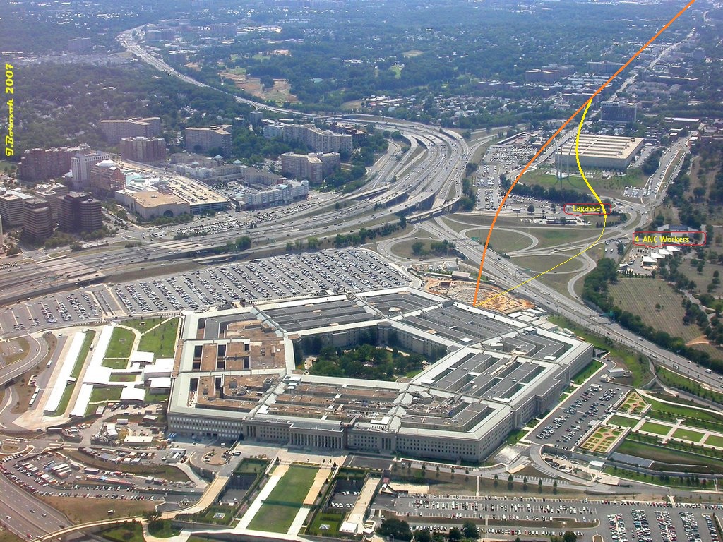
As you can see, the name of Sergeant Lagasse is written by me in yellow, at the CITGO gas station, where he was interviewed, and swore to have seen AA77 flying low, just 30 m NORTH of it. Just as his colleague swore in the same interview, he stood outside his police car in the parking lot on the other opposite western side of the station's road.
There were more than (>) 30 eyewitnesses interviewed on camera, which you all could have seen, or still can see, use the Internet Archive page I gave above, find the link names, if not existing anymore, by using the Search function here at ATS, in my 3765 posts here at ATS, nearly all only in this 9/11 Forum. There you'll find them (perhaps lost) links to the CIT Team interviews, and much more interviews on camera and mike, from many journalists, quickly arriving, that day.
The journalists have interviewed stopped car drivers on the road along the Pentagon.
Penny Elgas f.ex. said she saw the plane cross that road in FRONT of her car, clipping the radio antenna off a car in front of hers.
The interesting fact is, that we have Penny's stopped car on video filmed material, by one of these fast arrived journalists, with Penny standing to the right side beside it, and her car is clearly standing near those two low trees that stood there on 9/11/2001, right perpendicular to the AA77 impact hole in the West Wall at its column 16...
And many more eyewitness on several camera interviews, who unknowingly, but obviously tell, that they saw the AA77 B757-200 plane also from on that road, flying in a North of CITGO (NoC) flight path.
And 4 Arlington National Cemetery workers, who stood outside in front of their ANC buildings there, who all 4 saw AA77 fly low, NORTH of the gas station, or, i.o.w., it flew in between that gas station and their ANC buildings. I have written them also in that overview picture above, standing at their ANC buildings, in yellow characters : 4 ANC workers.
I can go on for hours more, but, just read back all my 3765 ATS 9/11 Forum posts, use the ATS Search function wisely.
If I read your post as meant i.m.op., you still defend the official flight path.?
While I give you the video evidence from the Department of Defense themselves, which they sat on for 5 years after 9/11, then handed it over, after a FOIA request forced them to admit they could or want not anymore to hold it to their chests.
It was from then on in the open for anyone to see, but now, it seems to be blocked again.
As was expected...it's again, unexpected for them, about some planners and handlers their necks again...
It's from now on the new harsh rule of their dangerous game.
a reply to: LaBTop
Damage of the Pentagon was of a large jet coming on at an angle, not straight in..
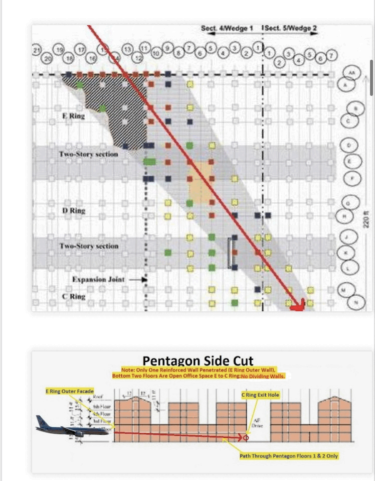
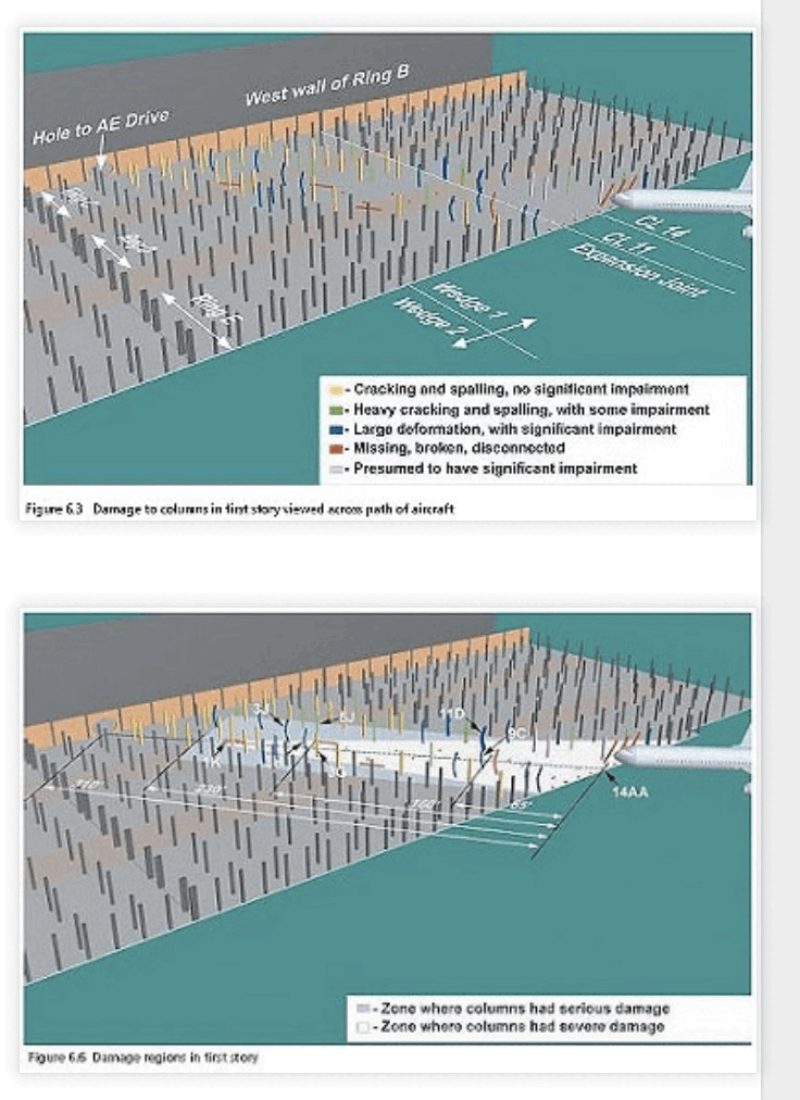
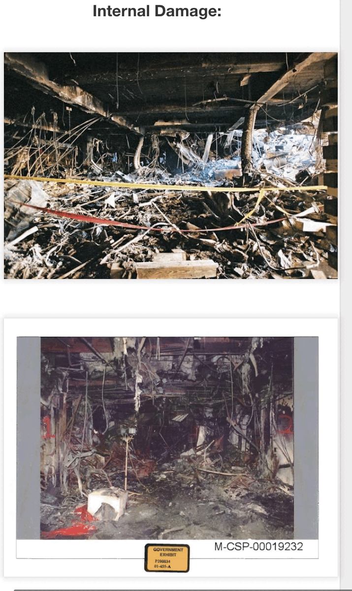
therightbloggerbastard.blogspot.com...
Damage of the Pentagon was of a large jet coming on at an angle, not straight in..


therightbloggerbastard.blogspot.com...
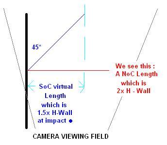
SoC and NoC means South and North of CITGO (gas station) and H-Wall means Height of Pentagon's West Wall.
The red lettering points to the left at a thin red horizontally drawn line, that stands for the full length of AA77, as seen by Cam1 and Cam1.
Thus, a perpendicular to the wall, i.o.w. in a 90 degrees flight path, incoming flight AA77 plane.
Between the 2 light blue arrows is the 0.7 x AA77's real length of 154 ft, so, a plane with a shorter, virtual length as would have been seen by the same cameras, proposed to eventually flying in under 45 degrees.
Imagine flight AA77 would have come flying in, on a by NIST proposed 45 degrees angled flight path to the Pentagon's western wall.
Which however proves to be totally impossible, if recorded with the same security cameras.
And should have recorded, a much shorter plane length, in that scenario, than the real length.
However, when the resulting imaginary too short (0.5 x) plane length pictures were then corrected for fish-eye distortion, a result from the extreme wide angle lenses in both cameras, they should now be showing a correct plane length of 107.8 ft, in fact only 0.7 times smaller/shorter than a real AA77, when shot with a flat lens.
That however imaginary distorted fish-eye picture, could then be corrected by the, free to buy since 2015 drawing program GIMP, as used by David Chandler, it would then have shown that virtual, by camera + lens, registered length, in fact 0.7 x 154 (real AA77) length, thus 107.8 feet.
It's by the way not 1.5 times the West Wall height, that would be 0.75 x the real length of AA77.
It's 0.7 times the real plane length of 154 ft, what Cam2 would have seen when the NIST scenario of an ~ 45 degrees incoming AA77 would have been registered by Security Cam2 and Cam1. Thus, in that imaginary case, a virtual length of 107.8 ft.
See my revised, very simple calculation, earlier on in this page.
a reply to: LaBTop
All items you can manipulate through verbal propaganda. Your post seems more like a long word salad to try to push the contradictory documented damage path off into the background.
The internal damage in the pentagon shows a large jet hit at an angle, not straight at the wall.
As supported by the damage in the lay down yard for construction outside the Pentagon, the low concrete wall an engine hit on the path to the Pentagon, the light poles, and the clipped trees/vegetation.
It’s a good thing your breed is thinning out. Not because you question. Not because the government can be trusted. Because the truth movement was a bunch of talking heads seeking fame and fortune off of lies. Manufacturing a product for consumption by conspiracist’s with only biased views.
At least government as some checks, balances, and oversight. The truth movement never could self regulate to keep the lies at bay, and it killed the truth movement.
edit on 12-12-2022 by WhatItIs because: (no reason given)
edit on 12-12-2022 by WhatItIs because: (no reason given)
Damage of the Pentagon was of a large jet coming on at an angle, not straight in..
No, have a second, preciser, look at your own posted diagram, and now, don't overlook the row of double columns side to side of each-other...
That's why only the left part of that double row, collapsed.
Imagine now, without that double columns row, how the collapse picture would have been, from above : mirrored.!
There must have been put a lot of effort and professionalism in the 9/11 planning.
That plane has for sure been remotely steered, by a software program, since no planner would have risked a human at that sensitive steer. And a kind of steering aid like a radar or IR or UV beacon must have been used.
You really believe those patsy's were even inside that plane.?
That was a meticulously planned and performed false flag operation.
However they did not foresee the fast expanding software boom, like prgrms as GIMP.
The internal damage in the pentagon shows a large jet hit at an angle, not straight at the wall.
No, it shows a near, between 98 and 85 degrees, head-on collision, planned to hit with the plane's long center beam, head-on that row of double columns.
Therefor causing the whole mass of everything behind the cockpit , especially the wing struts, and wing tanks, and fuselage tanks, to slump lightning fast to the right, while further entering, because of the slightly smaller then 90 degrees entrance angle, before it raced further in, but followed with a very fast changing to a much smaller entrance angle now, ending at 52 degrees, forced by change of momentum.
The plane now changed to a mass of liquidized aluminum mixed with jet fuel, and lots of other plane and building stuff.
With an increasing right sided momentum adding to the forward momentum, that only halted, when the whole plane was inside, without any further of that momentum. It slit side-lings in, because of that enormous change of momentum. The remaining material's forward momentum kept going through, up till that last ring's round hole in the outside corridor's brick wall.
Look at that diagram of yours, some heavy plane part halted at its deepest perpendicular point, at the corridor wall of the E ring. The rest went on much farther inside, in a quite different, speed momentum slackening resulting, and decreasing angle. It "took a corner".
Test what happened, like this :
Keep your left hand in front of your face, not too far away, fingers stiff aligned and thumb straight up, the trick is you must have enough flexibility left in the system, to feel any effect.
Now do the same with your right hand, only difference, keep it flat in front of you, thumb towards face. And in 10 cm of your upright held, tight left hand fingers.
Now aim at the top of your left hand's longest finger, let's call it your ring-finger.
Aim with your stiff held, still flat held right hand, with its forefinger, at the top of the ring-finger of your still flat held left hand. Keep hands 10 cm spaced.
Now punch fast, but with both hands' fingers stiffly held, with the top of your right hand's forefinger, onto the top of your left hand's ring-finger, and holding your right hand under a 85 degrees angle, away from you.
You feel, and see, that your right hand is forced backwards, away from you, if you hold both hands fingers stiff.
Since the biggest mass of your right hand is on the right side of the impact.
This is what happened when AA77 its nose cone reached the first double column of its row, under a very small different angle of attack than 90 degrees, let's suppose 85 degrees. The whole back part of that plane will instantly try to begin to swerve to the right.
The remote software aimed at something sending, hung up in that little green tree in front of column 16.
Otherwise they could not have reached such precision.
Meticulously planned...expect military style.
edit on 12/12/22 by LaBTop because: In last lines : under a very small different angle of attack than 90 degrees, let's suppose
85 degrees.
edit on 12/12/22 by LaBTop because: halted at its deepest perpendicular point, at the corridor wall of the E
ring.
edit on 12/12/22 by LaBTop because: The remaining material's forward momentum kept going (added material's)
Easy software " bug" :
If you use in your typed "reason for edit" text, the [i] and [/i] keys, (with [ and ] of course), then the reader can hoover over the Edit text, and the words that you changed or added, light white up. I typed right-accolade and left-accolade, but in preview it is [ and ] again. Interesting...
Try my above first edit, I sadly didn't use it in the next two. Tried it myself, only in Firefox.
This will hopefully not being removed or redirected by a Mod/Admin.?
Go Admins !
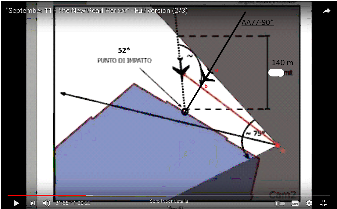
This is what the DoD its own security Cam2 really saw, recorded, and which was at last, in 2006, made public.
Only by the work of David Chandler, and before by Ken Jenkins, can we now at last see, the corrected by David, with the help of GIMP, DoD Cam2 its 9/11 security camera registered, by a fish eye lens produced material, thus after correction, in its real world dimensions. As shown, in its real 154 ft full length, which only can be camera registered at full length, when it flew perpendicular to the lens, which stood parallel to the North Wall, looking along the West Wall btw.
And thus flew that plane with its nose cone aimed straight at the West Wall, and not as by so many people slowly accepted before, as incoming, at varying per person or entity, from 45 to 52 degrees towards the Pentagon's West Wall.
As Massimo Mazzucco also drew himself, overwhelmed by all "additional" evidence, like WhatItIs, and so many others.
That plane, as is by Massimo Mazzucco drawn in there, is shown at a 1/3rd too long length.
A pitty, since he made that beautiful 5.5 hrs long documentary, I feel sorry to correct him on that length issue.
I drew the real length of AA77 in his published diagram, and on its real attack path, nearly perpendicular to the West Wall.
And the corrected material on his web page, was specifically only taken by David, from the original material, filmed on 9/11/2001, by DoD security cameras at the North Parking Entrance, as handed over to the public, per FOIA request, by the American DoD, in 2006.
edit on 12/12/22 by LaBTop because: This is what the DoD its own security Cam2 really saw, (hoover over with mouse, no clicking, changed
text, now white)
edit on 12/12/22 by LaBTop because: This is what the DoD its own security Cam2 really saw,
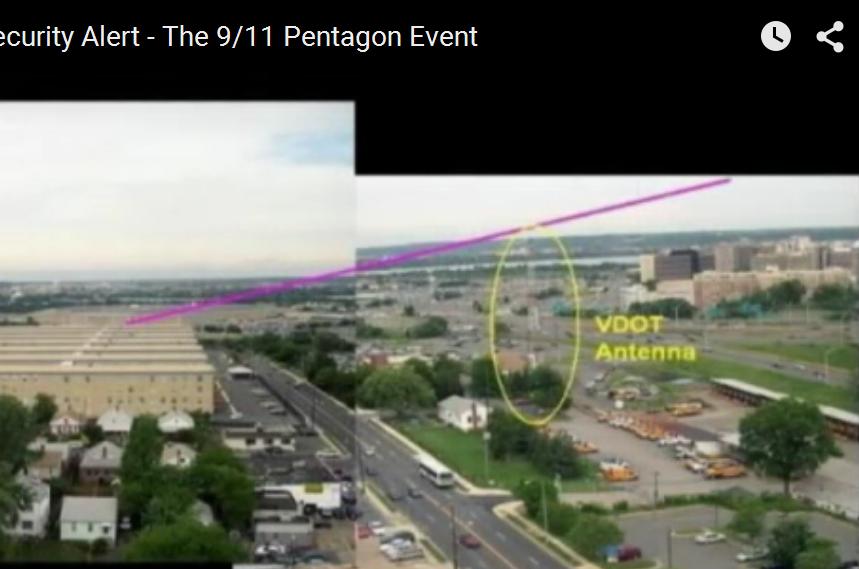
openedthirdeye ,
I have always heard and read that radio mast that you mentioned, described as VDOT Antenna, from the Virginia Department Of Transportation.
It seems quite difficult to even have a look at the last part of AA77's flightpath, from there, as we heard from a few interviewed eye and ear witnesses, since there are a lot of trees in the way, and especially when you know that Edward Paik and Terry Morin told us all, in the early days, on video, that AA77 already flew diagonally over the Navy Annex its 6 even higher building wings. Away from the road there, Columbia Pike. And that's what blocked view for all witnesses, except the ARMY guy, out of his office windows in the top back row of the last Annex Wing, overlooking the scene up to the Pentagon.
And this bulky Annex was situated on the rim of the top of a hill, so the left leaning, low flying flight AA77 its last trajectory, was even more difficult to be seen out of those low buildings around that VDOT antenna, also even from the parking there, caused by those obstructing trees, seen along the road, and the big bulky Navy Annex at the other roadside, where Terry worked And Edward was the owner of that small garage, a few buildings back from the Western Annex corner, on the Northern side of the Pike.
And this was also a police station ? Please show us its spot in this shortly after 9/11 taken photo.
So we can evaluate the AA77 scene possibilities from there.
edit on 12/12/22 by LaBTop because: Clicked post away....
edit on 12/12/22 by LaBTop because: Added poster's name,I react on, above my text. And that last line.
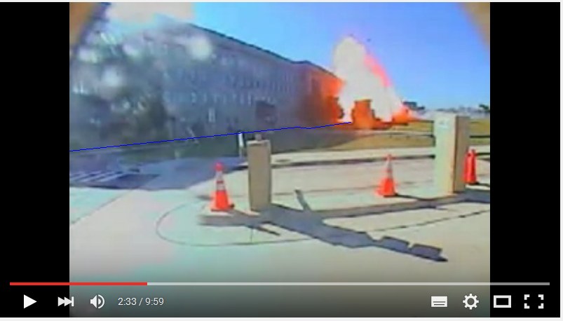
Found above picture back. Has a convenient thin blue line drawn in, by me, to accentuate the bottom of the Pentagon's West Wall. It was unclear to find without that line, because of the long grey/black sun created shadow. Pulling my contrast up, then, did it, and let me find it.
Now you have a good idea how to measure the height of the West Wall, compared to the impact spot. It's still half of the to measurable corrected length of AA77, is 2 x 77 = 154 ft.
And here you can see the Helipad control tower as that ~ 38 ft high, dark building in front of the impact's explosion.
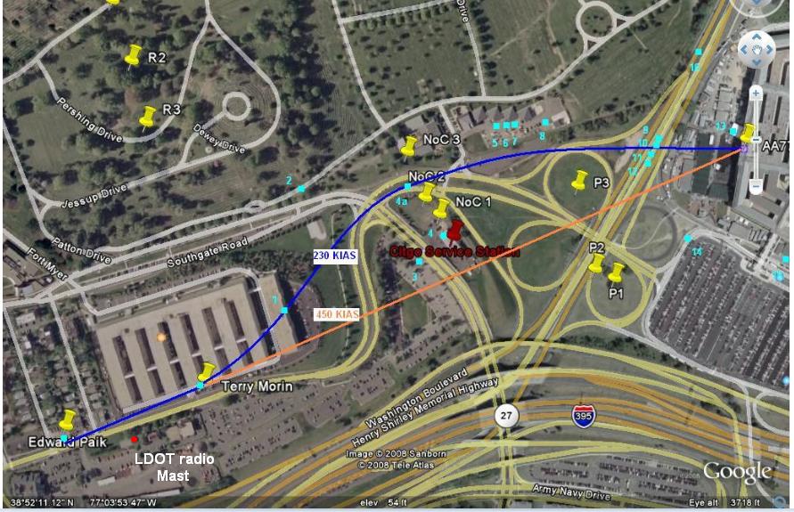
If you draw a straight flight path line from Edward Paik's reported position, and dismiss the used by me at that time, position, as extracted from the words of Terry Morin, which could be explained in several ways, then that would be an executable path, at those final speeds, as reported by radar and some early and later eyewitness.
new topics
-
Why Such An Uproar Over Non-US Citizens With H1-B Work Visas.
Social Issues and Civil Unrest: 3 hours ago -
Christmas Car Near Detroit…
Automotive Discussion: 5 hours ago -
Assetto Corsa EVO - a New Chapter in Simracing starts January 16th
Video Games: 7 hours ago -
The Phenomenon documentary by James Fox
Aliens and UFOs: 11 hours ago
top topics
-
Credit card debt
Relationships: 16 hours ago, 7 flags -
The Phenomenon documentary by James Fox
Aliens and UFOs: 11 hours ago, 7 flags -
President-elect Trump asks the Supreme Court to Let Tik-Tok Continue Operating in the U.S..
Mainstream News: 16 hours ago, 6 flags -
Why Such An Uproar Over Non-US Citizens With H1-B Work Visas.
Social Issues and Civil Unrest: 3 hours ago, 6 flags -
Christmas Car Near Detroit…
Automotive Discussion: 5 hours ago, 5 flags -
The Looking Glass - Episode 3: The Path of Least Resistance
Short Stories: 14 hours ago, 3 flags -
New UK Petition - Close the borders! Suspend ALL immigration for 5 years!
Regional Politics: 12 hours ago, 2 flags -
Assetto Corsa EVO - a New Chapter in Simracing starts January 16th
Video Games: 7 hours ago, 2 flags
active topics
-
Why Such An Uproar Over Non-US Citizens With H1-B Work Visas.
Social Issues and Civil Unrest • 17 • : grey580 -
Plane Crash Today --Azerbaijanian E190 passenger jet
Mainstream News • 65 • : andy06shake -
Post A Funny (T&C Friendly) Pic Part IV: The LOL awakens!
General Chit Chat • 7966 • : underpass61 -
‘Something horrible’: Somerset pit reveals bronze age cannibalism
Ancient & Lost Civilizations • 33 • : Flyingclaydisk -
Christmas Car Near Detroit…
Automotive Discussion • 4 • : Flyingclaydisk -
Danish Prime Minister said to keep 3 days worth of canned goods on hand
World War Three • 10 • : ARM19688 -
President-elect Trump asks the Supreme Court to Let Tik-Tok Continue Operating in the U.S..
Mainstream News • 25 • : xuenchen -
Kurakhove officially falls. Russia takes control of major logistics hub city in the southeast.
World War Three • 10 • : tomeville -
Treasury Secretary Janet Yellen Says The USA Will Be in Debt Default in Jan 2025 - Unless...
Mainstream News • 34 • : xuenchen -
Liberal Madness and the Constitution of the United States
US Political Madness • 19 • : charlest2
