It looks like you're using an Ad Blocker.
Please white-list or disable AboveTopSecret.com in your ad-blocking tool.
Thank you.
Some features of ATS will be disabled while you continue to use an ad-blocker.

S4 facility at Area 51 photographed during construction
page: 3share:
a reply to: Ophiuchus1
There is nothing particularly unusual about this topography if you live in the western United States. Those dark patches are exposures of volcanic basalt surrounded by alluvial deposits. You can see a lot of that in southern Nevada and throughout the Great Basin and Mojave Desert.
It's a pity this discussion got derailed by a debate about plasma balls. That probably deserves its own thread.
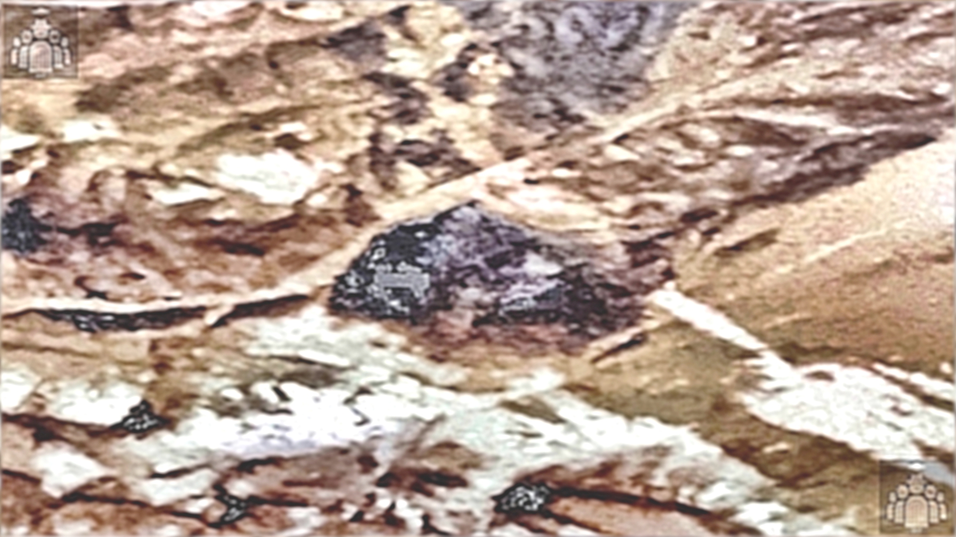
This thread is pure rubbish. There are no pictures that show any sort of construction or excavation in any of the (now multiple!) proposed sites for Lazar's "S-4 research facility." Earlier artist concepts of what Lazar described showed a row of hangar entrances built into the side of a hill directly adjacent to Papoose Lake. There is absolutely no evidence of such a facility existing. Additionally, John Lear is notorious for sketching all sorts of alleged secret facilities on maps of Nevada. These, too, have no basis in reality.
There is nothing particularly unusual about this topography if you live in the western United States. Those dark patches are exposures of volcanic basalt surrounded by alluvial deposits. You can see a lot of that in southern Nevada and throughout the Great Basin and Mojave Desert.
It's a pity this discussion got derailed by a debate about plasma balls. That probably deserves its own thread.
This thread is pure rubbish. There are no pictures that show any sort of construction or excavation in any of the (now multiple!) proposed sites for Lazar's "S-4 research facility." Earlier artist concepts of what Lazar described showed a row of hangar entrances built into the side of a hill directly adjacent to Papoose Lake. There is absolutely no evidence of such a facility existing. Additionally, John Lear is notorious for sketching all sorts of alleged secret facilities on maps of Nevada. These, too, have no basis in reality.
a reply to: A51Watcher
Humor me for a moment…..the 2 screenshots I captured below comes from a vid on the IAT website…..(except for my red arrow)


Is IAT suggesting, by the Lazar Sport Model reference, and other than the aerobatics of the object….. that this vid was shot near S4 / Papoose Lake area?
👽🤔🍹
Humor me for a moment…..the 2 screenshots I captured below comes from a vid on the IAT website…..(except for my red arrow)
Is IAT suggesting, by the Lazar Sport Model reference, and other than the aerobatics of the object….. that this vid was shot near S4 / Papoose Lake area?
👽🤔🍹
edit on 12-11-2021 by Ophiuchus1 because: (no reason given)
originally posted by: A51Watcher
originally posted by: Ectoplasm8
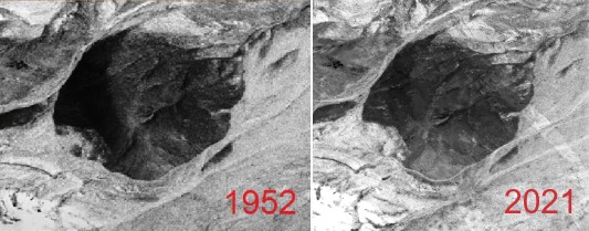
Are you saying that area was excavated in the late 80s then replaced on top with the exact same features as 1952? Here's an animation below of 1952 and 2021.
1988 photo -
Yes that is exactly what the 1988 and other images show.
And covering it over to look the same as before is exactly what camouflage experts do.
I don't have to claim it, the 1988 photo speaks for itself.
There is clearly excavation and construction in that photo.
And yes you correctly guessed the obvious explanation.
Claiming that area was excavated in the 80s then covered over by "camouflage experts" with the exact same landscape is a stretch by anyones imagination. I guess with a biased eye you can see it.
You can overprocess that 1988 photo as much as you want, but you can't get away from the 1952 and current 2021 images showing no present evidence of excavation whatsoever. You're saying these "camouflage experts" recreated the small rolling hills, valleys, wash out areas, replanted and positioned shrubs and low growing greenery exactly, made bare sandy spots on the mountain on top of this secret base?
I'm not making baseless or empty claims. Here's a different 2021 position I edited in gray scale. The sunlight angle is completely wrong and it still matches:
edit on 12-11-2021 by Ectoplasm8 because: (no reason given)
Adding the 4 Compass Cardinal Points of Interest at the S-4 Research Facility and S-4 High Ridge Facility
Coordinates bottom right corner of each pic.

The only theory for the possible existence of camouflaged hangar adjacent to the shoreline of the Papoose dry lake bed….is so while testing reversed engineered, or our own exotic craft….the dry lake bed is there to land on the lake in case of difficulties from flight, as well as easier to spot the craft that has to be forced to crash land due to inflight failures.
As above, the S-4 has two facilities….perhaps there is an extension facility, a third facility, with another S-4 name at ground level, at the base of a hill by the lake. Name not shown for reasons of security.
There is an off road vehicle trail from the S-4 Facilities, down to the Papoose dry lake bed.
Left to Right…Top to Bottom

One theory I have…I’ll throw out there, is that…..Radars being developed and tested at the S-4 Facilities (plural) are using reversed engineered exotic craft or our own exotic craft as targets, to develop radars to track actual EBE UFO’s and to tell the difference between theirs and ours IFF “Identification Friend or Foe”…..also to develop craft flight characteristics signatures.
That then puts it at three S-4 Facilities at two locations, both at the ridge S-4 Facilities location and the other at the Hill/Lake S-4 Facility location.
Something to ponder…..
👽🛸🧐🤔
Coordinates bottom right corner of each pic.
The only theory for the possible existence of camouflaged hangar adjacent to the shoreline of the Papoose dry lake bed….is so while testing reversed engineered, or our own exotic craft….the dry lake bed is there to land on the lake in case of difficulties from flight, as well as easier to spot the craft that has to be forced to crash land due to inflight failures.
As above, the S-4 has two facilities….perhaps there is an extension facility, a third facility, with another S-4 name at ground level, at the base of a hill by the lake. Name not shown for reasons of security.
There is an off road vehicle trail from the S-4 Facilities, down to the Papoose dry lake bed.
Left to Right…Top to Bottom
One theory I have…I’ll throw out there, is that…..Radars being developed and tested at the S-4 Facilities (plural) are using reversed engineered exotic craft or our own exotic craft as targets, to develop radars to track actual EBE UFO’s and to tell the difference between theirs and ours IFF “Identification Friend or Foe”…..also to develop craft flight characteristics signatures.
That then puts it at three S-4 Facilities at two locations, both at the ridge S-4 Facilities location and the other at the Hill/Lake S-4 Facility location.
Something to ponder…..
👽🛸🧐🤔
edit on 13-11-2021 by Ophiuchus1 because: (no reason given)
a reply to: Ophiuchus1
What needs to be pondered is someone believing that people are ignorant enough to first off believe these highly edited photos show construction at the mountain where "Bob Lazars lab" is located. Then believing the excuse that "camouflage experts" have come in and recreated the mountain perfectly and that's why you can't tell. You can't tell because nothing is actually there.
I can appreciate the efforts that go into creating this idea, but, the methods used by the I.A.T. need to be questioned.
originally posted by: Ectoplasm8
a reply to: Ophiuchus1
a reply to: A51Watcher
What needs to be pondered is someone believing that people are ignorant enough to first off believe these highly edited photos show construction at the mountain where "Bob Lazars lab" is located. Then believing the excuse that "camouflage experts" have come in and recreated the mountain perfectly and that's why you can't tell. You can't tell because nothing is actually there.
I can appreciate the efforts that go into creating this idea, but, the methods used by the I.A.T. need to be questioned.
Totally Agreed 🍻
I’m still waiting on a response to my question in my previous post (posted on Nov, 12 2021 @ 12:05 AM) about …..Does IAT suggest that the video I referenced from their website, shown below,….was videoed pointing the NV camera, towards the “S-4” area from which the object may appear to take off from on it’s flight….???
Here’s the vid I got my 2 screenshots from….
There’s a method to my madness….but I need their answer to my question before I expand my thoughts.
👽🛸🍻
edit on 13-11-2021 by Ophiuchus1 because: (no reason given)
a reply to: A51Watcher
It pisses me the # off. They have ZERO right to keep this info from us (the world). We have a RIGHT to know!
Id LOVE to find the bitch who decided to keep this a secret. He'd get a nice ass whooping.
It pisses me the # off. They have ZERO right to keep this info from us (the world). We have a RIGHT to know!
Id LOVE to find the bitch who decided to keep this a secret. He'd get a nice ass whooping.
Perhaps the higher elevation S-4 Facilities…Radar (mobile or otherwise) testing is just a cover story?
The concrete slabs might actually be Landing Pads for Craft testing and or Craft visitations! Night or Day.
Assuming those are slabs and not the roofs of buildings, hangars, etc. …HVAC units and ducting should then be seen in that regard.
Whose to say, that the small building (partially obscured) doesn’t have an elevator to an underground facility. Employee’s don’t need parking spots if they get shuttled to the facilities. The small building could even be a waiting area for drop offs / pickups for flights.
Hmmm 🤔


👽🛸🧐😉
The concrete slabs might actually be Landing Pads for Craft testing and or Craft visitations! Night or Day.
Assuming those are slabs and not the roofs of buildings, hangars, etc. …HVAC units and ducting should then be seen in that regard.
Whose to say, that the small building (partially obscured) doesn’t have an elevator to an underground facility. Employee’s don’t need parking spots if they get shuttled to the facilities. The small building could even be a waiting area for drop offs / pickups for flights.
Hmmm 🤔
👽🛸🧐😉
edit on 13-11-2021 by Ophiuchus1 because: (no reason given)
new topics
-
Sue Gray, Sir Keir Starmer's former Chief of Staff, Nominated for Peerage
Regional Politics: 1 hours ago -
Biden Nationalizes Another 50,000+ Student Loans as He Heads for the Exit
US Political Madness: 2 hours ago -
An Interesting Conversation with ChatGPT
Science & Technology: 11 hours ago
top topics
-
An Interesting Conversation with ChatGPT
Science & Technology: 11 hours ago, 7 flags -
Biden Nationalizes Another 50,000+ Student Loans as He Heads for the Exit
US Political Madness: 2 hours ago, 4 flags -
Sue Gray, Sir Keir Starmer's former Chief of Staff, Nominated for Peerage
Regional Politics: 1 hours ago, 1 flags
active topics
-
My personal experiences and understanding of orbs
Aliens and UFOs • 18 • : lilzazz -
Can someone 'splain me like I'm 5. Blockchain?
Science & Technology • 81 • : cherokeetroy -
Drone Shooting Arrest - Walmart Involved
Mainstream News • 34 • : Lazy88 -
Salvatore Pais confirms science in MH370 videos are real during live stream
General Conspiracies • 244 • : Lazy88 -
Mood Music Part VI
Music • 3747 • : lilzazz -
Russias War Against Religion in Ukraine
World War Three • 50 • : Oldcarpy2 -
Sue Gray, Sir Keir Starmer's former Chief of Staff, Nominated for Peerage
Regional Politics • 2 • : gortex -
US Federal Funding set to Expire December 20th. Massive CR on the way.
Mainstream News • 38 • : WeMustCare -
The Truth Behind the Manchester Airport "Police Assault" Video
Social Issues and Civil Unrest • 56 • : Oldcarpy2 -
An Interesting Conversation with ChatGPT
Science & Technology • 18 • : YouSir