It looks like you're using an Ad Blocker.
Please white-list or disable AboveTopSecret.com in your ad-blocking tool.
Thank you.
Some features of ATS will be disabled while you continue to use an ad-blocker.
share:
originally posted by: Arbitrageur
I thought this post you made of a post by Tom DeLonge was interesting too!
originally posted by: celltypespecific
originally posted by: mirageman
a reply to: celltypespecific
Where is your proof of this?
The proof is right here take a look at the board/advisory panel.... all former Gov. affiliates...
dpo.tothestarsacademy.com...
Big Lue in one of his interviews definetely made it clear that its for the best that they are working with the GOV.
ALSO this might be NEW.... I just noticed a SECOND member of AATIP (besides Lue) is in the public domain...right there on TTSA's website....
Dr. Colm Kelleher... on his bio it states "3 years on AATIP"
originally posted by: celltypespecific
IN PLAIN SIGHT...
I wonder if TDL thought he was in charge of what was going on at TTSA, then woke up one day and realized he was "along for the ride", doesn't it sort of read that way?
Great find!
edit on 20-9-2019 by celltypespecific because: (no reason given)
a reply to: coursecatalog
Hmmmmmm.
He seemed to be hinting that maybe the entities behind these UFOs were from another dimension or from the future and were here to guide us or something?
Hmmmmmm.
a reply to: coursecatalog
GOODMORNING!!!!!! HAPPY FRIDAY EVERYONE!!!!
Its been an AMAZING WEEK
Welcome to the our POSTDISCLOSURE world!!!!
GOODMORNING!!!!!! HAPPY FRIDAY EVERYONE!!!!
Its been an AMAZING WEEK
Welcome to the our POSTDISCLOSURE world!!!!
edit on 20-9-2019 by celltypespecific because: (no reason given)
.....anyway moving on...
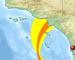
Lets get back to actually looking at available information and research that may or may not allow us to get a better understanding of the USS Nimitz UFO sighting.We maybe retreading some ground here, but there is some little nuggets here as well.
There are 3 main islands in this sighting area;
Santa Catalina
San Clemente
San Nicholas
These islands are of quite an interest to the US Military, with a rich history going back to World War 2 and there is still quite a large military presence in that area also. Whats interesting here is that the "incident" literally went through these 3 middle islands.

Source
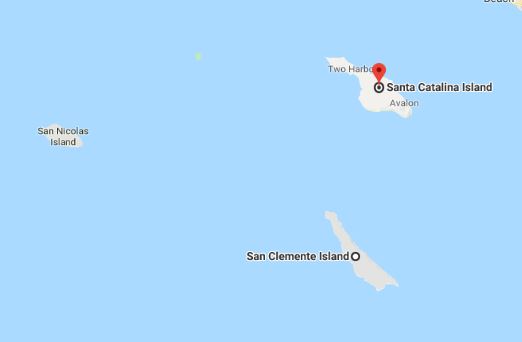
Here is a Google Maps screenshot so you can see the names of the island;

Santa Catalina;
We have covered this island before in this thread before so I will not go over the same old ground again....
Lets get back to actually looking at available information and research that may or may not allow us to get a better understanding of the USS Nimitz UFO sighting.We maybe retreading some ground here, but there is some little nuggets here as well.
There are 3 main islands in this sighting area;
Santa Catalina
San Clemente
San Nicholas
These islands are of quite an interest to the US Military, with a rich history going back to World War 2 and there is still quite a large military presence in that area also. Whats interesting here is that the "incident" literally went through these 3 middle islands.

Source
Here is a Google Maps screenshot so you can see the names of the island;

Santa Catalina;
We have covered this island before in this thread before so I will not go over the same old ground again....
edit on p321146192400 by pigsy2400
because: (no reason given)
a reply to: pigsy2400
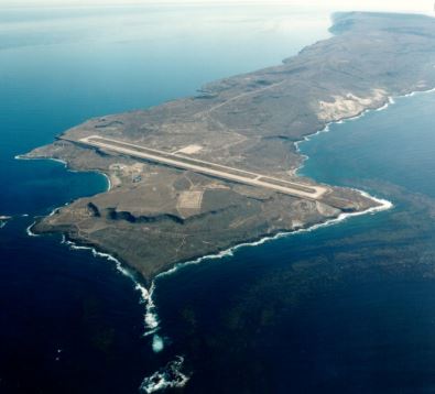
Did you know that the Island of San Clemente (the one near Santa Catalina and San Nicholas;
San Clemente;

Wiki;
You also are not allowed to fly Kites near and or around the island at specific times due to;
Source
The island also has a “fake” town built in the centre and the US Navy seals use it to train at a facility that cost $22 million dollars.
Can You Actually Go There?
Now you can actually go to the island, as a few PHd doctors and scientists have been there, but there are restrictions in place and there are areas where you simply are not allowed.
Did you know that the Island of San Clemente (the one near Santa Catalina and San Nicholas;
San Clemente;

Wiki;
"The island is officially uninhabited as of 2000 U.S. Census. It is estimated, however, that the number of military and civilian personnel present on the island at any given time is at least 300.[3] The city of San Clemente in Orange County, California is named after the island. "
You also are not allowed to fly Kites near and or around the island at specific times due to;
"The Navy routinely flies UNMANNED AIRCRAFT SYSTEMS (UAS)from and around San Clemente Island. Many of these UAS's are small and nearly invisible to other pilots. Any SAFETY ZONE SECTION HIGHLIGHTED in red on scisland.org, generally also has hazardous airspace associated with it. Please keep all aerial fish spotters and other aircraft out of hazardous operations areas for your safety and the safety of others."
Source
The island also has a “fake” town built in the centre and the US Navy seals use it to train at a facility that cost $22 million dollars.
Can You Actually Go There?
Now you can actually go to the island, as a few PHd doctors and scientists have been there, but there are restrictions in place and there are areas where you simply are not allowed.
edit on p231115192400 by pigsy2400 because: (no reason given)
a reply to: pigsy2400
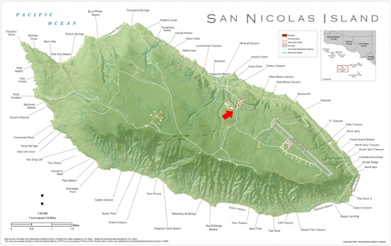
San Nicholas;

Munitions Testing
What Radar / Equipment is there?
Can you go there?
Source 1
Source 2
Source 3
Source 4
San Nicholas;

The uninhabited island is defined by the United States Census Bureau as Block Group 9, Census Tract 36.04 of Ventura County, California.[2] The Nicoleño Native American tribe inhabited the island until 1835. As of the 2000 U.S. Census, the island has since remained officially uninhabited, though the census estimates that at least 200 military and civilian personnel live on the island at any given time. The island has a small airport, though the 10,000 foot runway is the second longest in Ventura County (slightly behind the 11,102 ft. at the Naval Air Station Point Mugu). Additionally, there are several buildings including telemetry reception antennas.
Munitions Testing
San Nicolas Island was one of eight candidate sites to detonate the first atomic bomb before White Sands Proving Ground was selected for the Trinity nuclear test.[9] Between 1957 and 1973, and in 2004 and 2010, U.S. military research rockets were launched from San Nicolas Island. The launchpad was situated at 33°15′51.4″N 119°32′20.4″WCoordinates: 33°15′51.4″N 119°32′20.4″W. It remains part of the Pacific Missile Range.
What Radar / Equipment is there?
San Nicolas Island has numerous radars including three FPS-16 and two RIR-716 tracking radars, and one FPS-114 surface and one ARSR-3 air route surveillance radars. SNI is instrumented with metric tracking and surveillance radars, Global Positioning System (GPS) receivers, optics, telemetry, and communications necessary to support long range and over-the-horizon weapons testing, Fleet training and Theater Missile Defense exercises. SNI instrumentation also supports InterContinental Ballistic Missile (ICBM) and Polar satellite launches from the Western Range at VAFB. In addition, frequency monitoring, meteorological measurement systems and ordnance and launching facilities are available. Capabilities include launch of subscale and unmanned full-scale targets and launch sites for surface-launched weapons.
Can you go there?
San Nicolas Island is owned by the United States Government and controlled by the US Navy as San Nicolas Naval Facility. No public access to the island is allowed for hiking, backpacking, camping, etc. Sea kayaking is not allowed inside of 300 yards from shore.
Source 1
Source 2
Source 3
Source 4
edit on 20-9-2019 by celltypespecific because: (no reason given)
originally posted by: pigsy2400
a reply to: pigsy2400
San Nicholas;
The uninhabited island is defined by the United States Census Bureau as Block Group 9, Census Tract 36.04 of Ventura County, California.[2] The Nicoleño Native American tribe inhabited the island until 1835. As of the 2000 U.S. Census, the island has since remained officially uninhabited, though the census estimates that at least 200 military and civilian personnel live on the island at any given time. The island has a small airport, though the 10,000 foot runway is the second longest in Ventura County (slightly behind the 11,102 ft. at the Naval Air Station Point Mugu). Additionally, there are several buildings including telemetry reception antennas.
Munitions Testing
San Nicolas Island was one of eight candidate sites to detonate the first atomic bomb before White Sands Proving Ground was selected for the Trinity nuclear test.[9] Between 1957 and 1973, and in 2004 and 2010, U.S. military research rockets were launched from San Nicolas Island. The launchpad was situated at 33°15′51.4″N 119°32′20.4″WCoordinates: 33°15′51.4″N 119°32′20.4″W. It remains part of the Pacific Missile Range.
What Radar / Equipment is there?
San Nicolas Island has numerous radars including three FPS-16 and two RIR-716 tracking radars, and one FPS-114 surface and one ARSR-3 air route surveillance radars. SNI is instrumented with metric tracking and surveillance radars, Global Positioning System (GPS) receivers, optics, telemetry, and communications necessary to support long range and over-the-horizon weapons testing, Fleet training and Theater Missile Defense exercises. SNI instrumentation also supports InterContinental Ballistic Missile (ICBM) and Polar satellite launches from the Western Range at VAFB. In addition, frequency monitoring, meteorological measurement systems and ordnance and launching facilities are available. Capabilities include launch of subscale and unmanned full-scale targets and launch sites for surface-launched weapons.
Can you go there?
San Nicolas Island is owned by the United States Government and controlled by the US Navy as San Nicolas Naval Facility. No public access to the island is allowed for hiking, backpacking, camping, etc. Sea kayaking is not allowed inside of 300 yards from shore.
Source 1
Source 2
Source 3
Source 4
Excellent reporting Pigsy!
And for context of the events
Skip to 10:30
originally posted by: celltypespecific
a reply to: coursecatalog
GOODMORNING!!!!!! HAPPY FRIDAY EVERYONE!!!!
Its been an AMAZING WEEK
Welcome to the our POSTDISCLOSURE world!!!!
Boy, they really repaired the glitch!
They took you back to be retooled, and you got a tuneup.
Your program is running optimally
edit on 20-9-2019 by Willtell because: (no reason given)
edit on 20-9-2019 by Willtell because: (no reason
given)
So we have previous nuclear test sites aka Nuclear Weapons, Over the Horizon Radar installations, UAS/UAV launch sites and a pletheora of radar
tracking facilities on these islands collectively.
Also, access to the SPY-1 sattelite system (which was alledgely rebooted to ensure that the radar tracks were not glitches) and the brand new radar array on the USS Nimitz and the Hawkeyes that were in the air at the time....
There is also the testing of dropping an amount of drones and then "recreating" the illusion of many more drones in a hive mind project from F18s
This is starting to look more and more like a military test in my opinon. The statements released by the Navy state (paraphrasing here) that they havent released any theories or reviews on what was monitored.
Now if it was a secret test, then of course they wouldnt...they mention they "havent released" - does not mean that they havent investigated, because of course they have! AATIP may well have been a program to investigate such Unknown incursions into training / military / Navy Airspace.
If AATIP wasnt granted SAP access (which still wouldnt grant them access to other SAPs) and the test was a SAP - boom! That why AATIP probably started getting somewhere but after a while
Because they were not allowed access to those SAPs that created the problems...
I am of the opinion that its more likely a military test and whatever was in the skies is known to the Navy - that DOES NOT MEAN that its Aliens or "flying saucers"; considering;
Location of the Sighting
Installations in that region
Equipment Utilised on the Carrier Group
Potential Testing that is already carried out in the area
Also, access to the SPY-1 sattelite system (which was alledgely rebooted to ensure that the radar tracks were not glitches) and the brand new radar array on the USS Nimitz and the Hawkeyes that were in the air at the time....
There is also the testing of dropping an amount of drones and then "recreating" the illusion of many more drones in a hive mind project from F18s
This is starting to look more and more like a military test in my opinon. The statements released by the Navy state (paraphrasing here) that they havent released any theories or reviews on what was monitored.
Now if it was a secret test, then of course they wouldnt...they mention they "havent released" - does not mean that they havent investigated, because of course they have! AATIP may well have been a program to investigate such Unknown incursions into training / military / Navy Airspace.
If AATIP wasnt granted SAP access (which still wouldnt grant them access to other SAPs) and the test was a SAP - boom! That why AATIP probably started getting somewhere but after a while
"Created nothing but reams of paperwork"
Because they were not allowed access to those SAPs that created the problems...
I am of the opinion that its more likely a military test and whatever was in the skies is known to the Navy - that DOES NOT MEAN that its Aliens or "flying saucers"; considering;
Location of the Sighting
Installations in that region
Equipment Utilised on the Carrier Group
Potential Testing that is already carried out in the area
edit on p061243192400 by pigsy2400 because: (no reason given)
edit on
p071239192400 by pigsy2400 because: (no reason given)
edit on Fri Sep 20 2019 by Jbird because: fixed embed code
edit on 20-9-2019 by celltypespecific because: (no reason given)
originally posted by: pigsy2400
So we have previous nuclear test sites aka Nuclear Weapons, Over the Horizon Radar installations, UAS/UAV launch sites and a pletheora of radar tracking facilities on these islands collectively.
Also, access to the SPY-1 sattelite system (which was alledgely rebooted to ensure that the radar tracks were not glitches) and the brand new radar array on the USS Nimitz and the Hawkeyes that were in the air at the time....
There is also the testing of dropping an amount of drones and then "recreating" the illusion of many more drones in a hive mind project from F18s
This is starting to look more and more like a military test in my opinon. The statements released by the Navy state (paraphrasing here) that they havent released any theories or reviews on what was monitored.
Now if it was a secret test, then of course they wouldnt...they mention they "havent released" - does not mean that they havent investigated, because of course they have! AATIP may well have been a program to investigate such Unknown incursions into training / military / Navy Airspace.
If AATIP wasnt granted SAP access (which still wouldnt grant them access to other SAPs) and the test was a SAP - boom! That why AATIP probably started getting somewhere but after a while
"Created nothing but reams of paperwork"
Because they were not allowed access to those SAPs that created the problems...
I am of the opinion that its more likely a military test and whatever was in the skies is known to the Navy - that DOES NOT MEAN that its Aliens or "flying saucers"; considering;
Location of the Sighting
Installations in that region
Equipment Utilised on the Carrier Group
Potential Testing that is already carried out in the area
Excellent reporting Pigsy!!!
And for actual context surrounding the events
Skip to 10:30
a reply to: pigsy2400
Yep and don't forget what was going on on the date Dave Sex Favor saw his tic-tac
Doesn't prove this was a test on an unsuspecting Navy task force. But there is enough circumstantial evidence to at least question it.
Yep and don't forget what was going on on the date Dave Sex Favor saw his tic-tac
Nimitz CSG Practices the Art of War at Sea - Without Getting Underway
NORTH ISLAND, Calif. (NNS) -- Tactical Training Group Pacific (TACTRAGRUPAC) and four ships of Commander, Carrier Strike Group (CCSG) 11 conducted a virtual exercise Oct. 26-27 via secure wide area network and satellite, while they remained in port at bases in San Diego and Hawaii.....
San Diego-based USS Nimitz (CVN 68), USS Princeton (CG 59) and USS Higgins (DDG 76), and the Hawaii-based USS Chafee (DDG 90) took part in the exercise, along with the staffs of CCSG 11 and Destroyer Squadron 23....
"The San Diego-based ships connected via Link-16, Chafee connected via Link-11, and we all saw the same picture," said Lt. Rob Hauck, the CCSG 11 tactical flag command center officer and a key training leader for the BGIE-WC.
"All the ships see radar, video, IFF (Identification Friend or Foe); there's no difference. You can't see the difference between real world now and what the operators were seeing during the exercise."
Full Story : web.archive.org...
Doesn't prove this was a test on an unsuspecting Navy task force. But there is enough circumstantial evidence to at least question it.
a reply to: mirageman
Ah yes, they were docked!
Elizondo might be right that people in the DOD are mad about all this nonsense as it all essentially backs the US NAVY into a corner.
1) it makes them appear stupid, as their billion dollar warships and cutting edge radar mean nothing as it's easy to encroach on their airspace with impunity, which will bring uncomfortable questions.
2) By explaining the objects as UAP, that will and has stoked the ufo community into UFO believer territory and may have given mainstream exposure into secret testing of classified projects, which will bring uncomfortable questions.
Either way, there maybe uncomfortable questions, so I can imagine the NAVY are gonna be pretty narked. This may explain why the pentagon has issued contradictory statements...
All theory of course
edit on p17345192400 by pigsy2400 because: (no reason given)
Conspiratorial perspective:
The Gimbal videos were exposed so that the public could chew on them: their veracity, their reality, their meaning, etc.
It is a classic straw-man conundrum so that some authority could come along, in this case, the US Navy, and confirm TTSA’s side of the story. Then TDL and TTSA could get all this praise that he was right all along and what else is he right about.
It's the problem, reaction, solution syndrome.
It will be interesting to see what's next on their agenda
BREAKING------> New Video of UAP/ORB by Big Bob:
Below is directly from Bigelow Aerospace a company (connected to AATIP/TTSA). Its entiled "our small contribution"
What do you make of it?
I think its the metamaterials displayed on the table (as referenced in the NYTimes article)....the orb is just a distraction.
New UAP/ORB Video
Below is directly from Bigelow Aerospace a company (connected to AATIP/TTSA). Its entiled "our small contribution"
What do you make of it?
I think its the metamaterials displayed on the table (as referenced in the NYTimes article)....the orb is just a distraction.
New UAP/ORB Video
edit on 20-9-2019 by celltypespecific because:
(no reason given)
extra DIV new topics
-
Ford Motor Company sold to Elon Musk
Other Current Events: 1 hours ago -
President Biden pardons his son Hunter Biden
US Political Madness: 5 hours ago -
Biden pardons his son Hunter despite previous pledges not to
Mainstream News: 5 hours ago -
Studies show that watching a beaver eat cabbage lowers stress by 17%
Health & Wellness: 9 hours ago -
Salvatore Pais confirms science in MH370 videos are real during live stream
General Conspiracies: 10 hours ago
top topics
-
James Webb Telescope Takes a Look at the Sombrero Galaxy
Space Exploration: 13 hours ago, 11 flags -
Biden pardons his son Hunter despite previous pledges not to
Mainstream News: 5 hours ago, 11 flags -
President Biden pardons his son Hunter Biden
US Political Madness: 5 hours ago, 11 flags -
Australia passes social media ban for children under 16
Social Issues and Civil Unrest: 12 hours ago, 6 flags -
Salvatore Pais confirms science in MH370 videos are real during live stream
General Conspiracies: 10 hours ago, 5 flags -
Studies show that watching a beaver eat cabbage lowers stress by 17%
Health & Wellness: 9 hours ago, 4 flags -
Ford Motor Company sold to Elon Musk
Other Current Events: 1 hours ago, 0 flags
active topics
-
Australia passes social media ban for children under 16
Social Issues and Civil Unrest • 9 • : Station27 -
Ford Motor Company sold to Elon Musk
Other Current Events • 1 • : DaRAGE -
Biden's "Reckless" Decision To Escalate Russia-Ukraine War
World War Three • 127 • : 777Vader -
Biden pardons his son Hunter despite previous pledges not to
Mainstream News • 24 • : Guyfriday -
Mood Music Part VI
Music • 3724 • : MRTrismegistus -
-@TH3WH17ERABB17- -Q- ---TIME TO SHOW THE WORLD--- -Part- --44--
Dissecting Disinformation • 3446 • : 777Vader -
President-Elect Trump Picks Indian-American KASHYAP P. PATEL for F.B.I. Director.
2024 Elections • 44 • : WeMustCare -
President Biden pardons his son Hunter Biden
US Political Madness • 20 • : DontTreadOnMe -
I thought Trump was the existential threat?
World War Three • 183 • : Xtrozero -
Russia Ukraine Update Thread - part 3
World War Three • 6895 • : Arbitrageur

