It looks like you're using an Ad Blocker.
Please white-list or disable AboveTopSecret.com in your ad-blocking tool.
Thank you.
Some features of ATS will be disabled while you continue to use an ad-blocker.
share:
a reply to: violet>>>. They hype these storms and then suddenly when they get close to land or make landfall and independent
meteorologists or weather watchers can share THEIR readings, suddenly it gets downgraded. Harvey was a monster storm but not so much in size or
strength as in what it did. It parked itself and wouldn't budge near the coast and just dumped rain. That was from a high pressure that stopped it in
its tracks. Is this a CAT 5, a CAT 4 or a bad CAT 3? We don't know. It all ties in to Global Warming narratives.
originally posted by: wasobservingquietly
According to the Weather Channel,
Irma is now a category 5.
Sustained winds of 175 mph & could even intensify over warmer water.
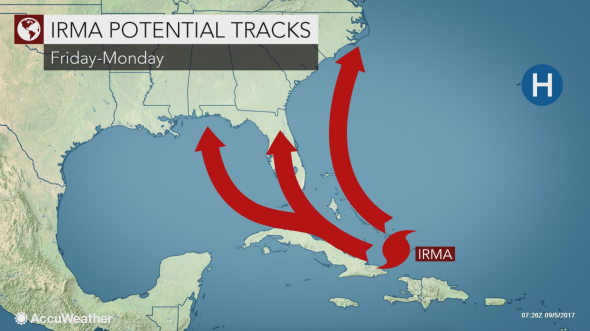
Looks like the most likely path will be up the spine of Florida.
WOQ
Good grief!! You only need 157 mph to become a Category 5. Wow...
I was asked by PM about the worst storms that have hit Florida. Maybe there are others that are interested, so I am sharing in an general post.
I was stationed at Homestead AF base when Andrew came through. He did a lot of costly damage and landed twice. I was lucky, I suffered no personal damage. I was in Broward when David paid a visit, twice. I lost a fence and a tree in my front yard that I was planning on cutting down anyway. Again lucky. It fell between my house and my neighbor's missing both houses.
List of Florida hurricanes
I didn't have anything untoward happen with all of these storms except Wilma. When Wilma passed I thought all was well because when I went to check during the eye passing, everything was fine. Then we got hit with the back side of Wilma and it was the first time I was every afraid during a hurricane.
I was sitting in the interior bathroom with my mom bedded down in the bathtub. All the critters were in there with us. A Rhodesian Ridgeback, a Yellow Lab, two cats, and 2 humans all tightly packed in a tiny bathroom but we were cozy. Then I heard it. The classic sound of a freight train. I could do nothing but wait. When the wind stopped and I ventured out to check the damage, I was shocked. Both screened in porches, front and back, were unscathed. I could see the trees along the side of my house had been topped out and the trees around my house had fallen like dominoes all around my house in a circle. Not one had touched the house.
The tornado had travel right long the side of my house, right down the side of my neighbor's house across the street and completely demolished our neighbor's house on the next street over. The neighbor was not there. He was the only one of us that had evacuated. I think that was the greatest example I have of why it is important that you follow your gut.
There used to be a time that hurricanes were named after a woman because they said they were temperamental and unpredictable. PC or not, the description is accurate. You never know what a hurricane is going to do until it does it. You can track, guess and pray. The only real thing you can do it wait.
In the period between 1975 and 1999, 83 tropical or subtropical cyclones affected the state, which collectively resulted in $45 billion (2008 USD) in damage, primarily from Hurricane Andrew, and 54 direct casualties. The 1985 season was the year with the most tropical cyclones affecting the state, with a total of 8 systems. Every year included at least 1 tropical cyclone affecting the state. The strongest hurricane to hit the state during the period was Hurricane Andrew, which was one of only three Category 5 hurricanes to strike the United States. Andrew, at the time, was the costliest tropical cyclone in United States history and remains the second-costliest. Additionally, Hurricanes Eloise, David, and Opal hit the state as major hurricanes.
I was stationed at Homestead AF base when Andrew came through. He did a lot of costly damage and landed twice. I was lucky, I suffered no personal damage. I was in Broward when David paid a visit, twice. I lost a fence and a tree in my front yard that I was planning on cutting down anyway. Again lucky. It fell between my house and my neighbor's missing both houses.
List of Florida hurricanes
The period from 2000 to the present was marked by several devastating North Atlantic hurricanes; as of 2013, 63 tropical or subtropical cyclones have affected the U.S. state of Florida. Collectively, cyclones in Florida over that period resulted in over $100 billion in damage[10] (2008 USD). Additionally, tropical cyclones in Florida were responsible for 69 direct fatalities and at least 80 indirect ones during the period. Eight cyclones affected the state in both 2003 and 2005, which were the years with the most tropical cyclones impacting the state. Every year included at least one tropical cyclone affecting the state. The strongest hurricane to hit the state during the period was Hurricane Charley, which was the strongest hurricane to strike the United States since Hurricane Andrew. Additionally, Hurricanes Jeanne, Dennis, Wilma, and Hurricane Ivan made landfall on the state as major hurricanes.
I didn't have anything untoward happen with all of these storms except Wilma. When Wilma passed I thought all was well because when I went to check during the eye passing, everything was fine. Then we got hit with the back side of Wilma and it was the first time I was every afraid during a hurricane.
I was sitting in the interior bathroom with my mom bedded down in the bathtub. All the critters were in there with us. A Rhodesian Ridgeback, a Yellow Lab, two cats, and 2 humans all tightly packed in a tiny bathroom but we were cozy. Then I heard it. The classic sound of a freight train. I could do nothing but wait. When the wind stopped and I ventured out to check the damage, I was shocked. Both screened in porches, front and back, were unscathed. I could see the trees along the side of my house had been topped out and the trees around my house had fallen like dominoes all around my house in a circle. Not one had touched the house.
The tornado had travel right long the side of my house, right down the side of my neighbor's house across the street and completely demolished our neighbor's house on the next street over. The neighbor was not there. He was the only one of us that had evacuated. I think that was the greatest example I have of why it is important that you follow your gut.
There used to be a time that hurricanes were named after a woman because they said they were temperamental and unpredictable. PC or not, the description is accurate. You never know what a hurricane is going to do until it does it. You can track, guess and pray. The only real thing you can do it wait.
edit on 5-9-2017 by NightSkyeB4Dawn because: Forgot the link.
originally posted by: Lilroanie
a reply to: dawnstar
Hah My family just came back from Ventura/Santa Barbara last night and were in that in the harbor! My sis said it was crazy, they were hanging out on the boat fishing one minute then BOOM everything was going nuts!
All my friends and family in SB had a field day with that lol.
originally posted by: Dutchowl
a reply to: violet>>>. They hype these storms and then suddenly when they get close to land or make landfall and independent meteorologists or weather watchers can share THEIR readings, suddenly it gets downgraded. Harvey was a monster storm but not so much in size or strength as in what it did. It parked itself and wouldn't budge near the coast and just dumped rain. That was from a high pressure that stopped it in its tracks. Is this a CAT 5, a CAT 4 or a bad CAT 3? We don't know. It all ties in to Global Warming narratives.
I'm not seeing much hype with this one, but then again I'm ignoring hype. I'm just looking at reliable weather sources. I'm trying not to inject hype into my thread anyways.
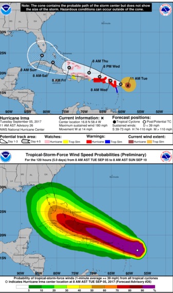
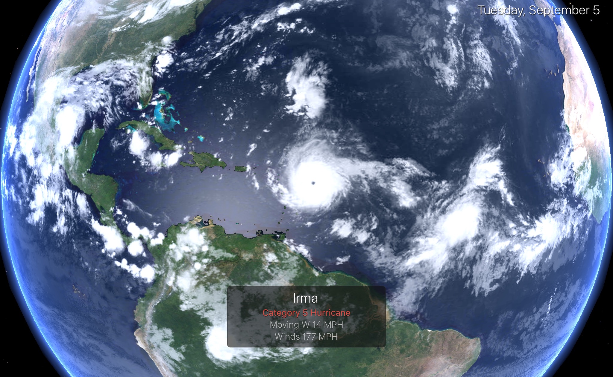
It's a c at 5 now, but can be 3,4 or 5 by the time it reaches Florida. Where it impacts Florida must be stressed it's still uncertain, but floridians should still prepare in case it hits their area. Prepare for the worst and hope for the best.
Latest update:
11:00 AM AST Tue Sep 5
Cat 5
Location: 16.8°N 58.4°W
Moving: W at 14 mph
Min pressure: 931 mb
Max sustained: 180 mph
edit on 5-9-2017 by violet because: (no reason given)
a reply to: violet
Most of your veteran Floridians are used to the drill. It took me two days to get gas because I was just topping off and the lines were ridiculous. Went out to Costco on Saturday to pick up some items for Sunday and the line for water was wrapped around the inside of the store.
My brother went out to get some additional items, just in case, and he said the shelves were almost empty every place he went. We live in a rural area so many it is different in the city, but folks seem to be gearing up super early this time around.
Most of us stay geared up year round, but some things always go off the shelves fast. Water and batteries are on the top of that list.
a reply to: NightSkyeB4Dawn
Yes I bet you're all used to this by now.
Pays to keep stocked up on suppplies. I'm restocking my water and batteries now in expectation of our usual PNW storms. In heavy rains my water gets turbid and you can't drink it, the winds bring trees down and widespread power outages. In fact it's quite windy today. Hard to tell if it's overcast or just the wildfires smoke. The sun is red. There's an eerie peach glow. Some of the newcomers to the area don't know how intense our winds can get. Obviously nothing like a hurricane but maybe cat 1 strength gusts at times.
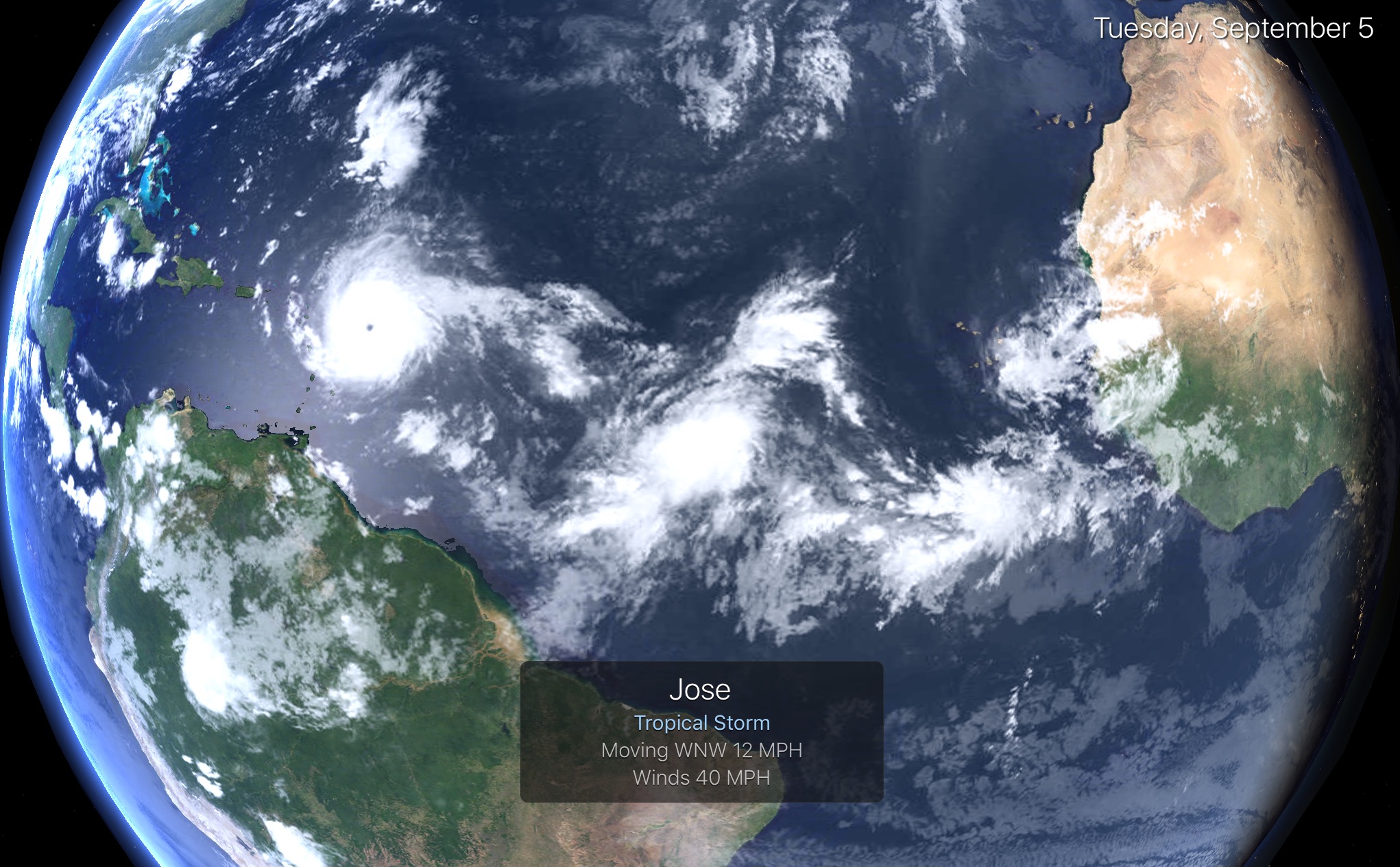
By the way Tropical Storm Jose is lurking in the Atlantic . Another one to keep an eye on.
You can see it's right behind Irma
11:00 AM AST Tue Sep 5
Location: 12.3°N 39.1°W
Moving: WNW at 13 mph
Min pressure: 1008 mb
Max sustained: 40 mph
You can see it's right behind Irma
11:00 AM AST Tue Sep 5
Location: 12.3°N 39.1°W
Moving: WNW at 13 mph
Min pressure: 1008 mb
Max sustained: 40 mph

edit on 5-9-2017 by violet because: (no reason given)
South Florida Residents Already Prepping for Storm
Officials in the Florida Keys have activated the Monroe County Emergency Operations Center, and have ordered mandatory evacuations for both visitors and residents ahead of Hurricane Irma. Visitors will begin evacuating at sunrise on Wednesday, the county said in a Facebook post, while schedules for resident evacuations are still being determined.
“If ever there was a storm to take seriously in the Keys, this is it,” Monroe County Emergency Management Director Martin Senterfitt told WPLG. “The sooner people leave, the better.”
Starting Wednesday, all schools in the Florida Keys will be closed until further notice, the Monroe County School District said in a statement on Tuesday.
Miami-Dade County officials are advising residents living in low-lying areas to start evacuating tomorrow. Residents in the Miami area are already getting "jittery" ahead of the approaching storm, according to the Miami Herald; bottled water was in short supply and stores are packed with shoppers.
“It’s gonna get crazy and I’d rather get it done before there’s more people and it’s chaos,” Mike Kizek, who was buying groceries at the Publix in Morningside, told the Herald. “If I waited, then all that would be left is cans of tomato sauce.”
weather.com...
edit on 5-9-2017 by NightSkyeB4Dawn because: Sorry. Posted during class break, formatting got screwed up.
Irma is turning into one of the biggest storms on record.....
I heard Jim Cantore on the Weather Channel this morning. Saying a Florida peninsula hit is pretty much a given....just depends how far east or west it will rack along the peninsula.
Category 5 Irma the 5th Strongest Atlantic Hurricane on Record
and
I heard Jim Cantore on the Weather Channel this morning. Saying a Florida peninsula hit is pretty much a given....just depends how far east or west it will rack along the peninsula.
Category 5 Irma the 5th Strongest Atlantic Hurricane on Record
Hurricane Irma intensified into an extremely dangerous high-end Category 5 storm with top sustained winds of 180 mph on Tuesday morning, putting it among the strongest Atlantic hurricanes ever observed. Irma's winds are the most powerful ever measured in an Atlantic hurricane north of the Caribbean and east of the Gulf of Mexico. Measurements from Hurricane Hunter aircraft found peak winds of close to 180 mph, well above the 157-mph threshold for Category 5 strength. At 11:07 am EDT, a dropsonde in Irma's eye measured a central pressure of 927 millibars, 4 mb lower than the previous pass, so Irma is still strengthening.
and
Irma poses the most serious hurricane threat to northern Cuba and Florida since at least Hurricane Andrew (1992). Since Sunday night, computer models have agreed that Irma will continue west-northwest before making a fairly sharp right-hand turn in the vicinity of the Florida Straits over the weekend. The level of agreement among models and over time has been quite high for a forecast in the 5-day range. Given this agreement and Irma’s Category 5 strength, residents of Florida must take this hurricane with the utmost seriousness.
a reply to: DontTreadOnMe
The winds on this thing are now 185 mph. No such thing as a cat 6 but if there was it would be almost that. Depending on if it goes over Cuba and weakens, its still anyone's guess at its strength when impacting Florida
Latest update:
Category 5
2:00 PM AST Tue Sep 5
Location: 16.9°N 59.1°W
Moving: W at 14 mph
Min pressure: 926 mb
Max sustained: 185 mph
edit on 5-9-2017 by violet because: (no reason given)
2pm AST NHC
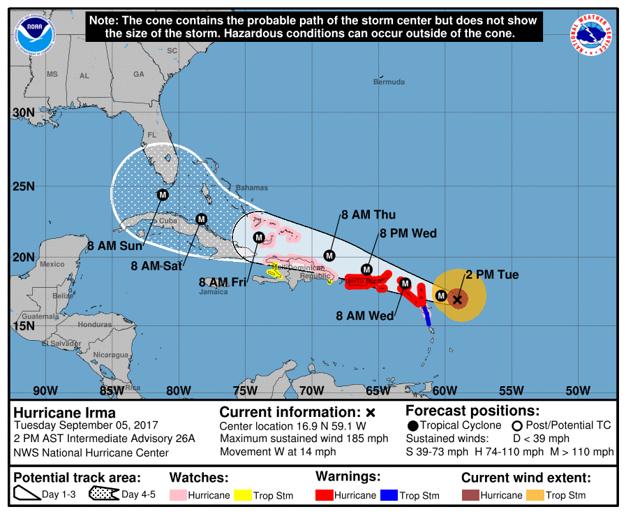
WATCHES AND WARNINGS IN EFFECT:
A Hurricane Warning is in effect for...
* Antigua, Barbuda, Anguilla, Montserrat, St. Kitts, and Nevis
* Saba, St. Eustatius, and Sint Maarten
* Saint Martin and Saint Barthelemy
* British Virgin Islands
* U.S. Virgin Islands
* Puerto Rico, Vieques, and Culebra
A Hurricane Watch is in effect for...
* Guadeloupe
* Dominican Republic from Cabo Engano to the northern border with
Haiti
* Haiti from the northern border with the Dominican Republic to Le
Mole St. Nicholas
* Turks and Caicos Islands
* Southeastern Bahamas
A Tropical Storm Warning is in effect for...
* Guadeloupe
* Dominica
A Tropical Storm Watch is in effect for...
* Dominican Republic from south of Cabo Engao to Isla Saona
* Haiti from south of Le Mole St. Nicholas to Port-Au-Prince
edit on 5-9-2017 by violet because: (no reason given)
a reply to: violet
For me the aftermath is always the worst.
Since I live in the country, they consider us less important, fewer numbers, so we always get our power back last.
After Wilma it took them, two months to get our power restored.
Downed trees block important roads and because it is all private out here, we have to clear our own roads. No problem. We all have chain saws and we know how to use them.
We look after each other our here. I just got off the phone with one of my neighbors, he is getting the line-up for the installation of storm shutters, if needed. We work together and we do one house at a time until we have put up the shutters on all of our homes.
I am the resident Vet/Nurse, so I just need to add a couple more items to my kit, since I had to patch up a neighbor a couple of days ago, so I am a little short.
We prepare for the worst and pray for the best. Most important is to be smart and to be safe.
new topics
-
Paramilitary Leaks - John Williams
Whistle Blowers and Leaked Documents: 1 hours ago -
Some sausage, some chicken, some sauce, some onions and some garlic...and some peppers!
Food and Cooking: 2 hours ago -
Hearing more ambulances lately
Medical Issues & Conspiracies: 3 hours ago -
Los Angeles brush fires latest: 2 blazes threaten structures, prompt evacuations
Mainstream News: 3 hours ago -
House Passes Laken Riley Act
Mainstream News: 3 hours ago -
The more I think about it
General Chit Chat: 4 hours ago -
What Comes After January 20th
Mainstream News: 6 hours ago -
Canada as a state .. how would it work?
General Chit Chat: 6 hours ago -
Those stupid GRAVITE commercials
Rant: 6 hours ago -
Let's Buy Greenland
General Chit Chat: 7 hours ago
top topics
-
House Passes Laken Riley Act
Mainstream News: 3 hours ago, 19 flags -
What Comes After January 20th
Mainstream News: 6 hours ago, 17 flags -
Claim: General Mark Milley Approved Heat and Sound Directed Energy Weapons During 2020 Riots
Whistle Blowers and Leaked Documents: 12 hours ago, 12 flags -
Planned Civil War In Britain May Be Triggered Soon
Social Issues and Civil Unrest: 10 hours ago, 6 flags -
Let's Buy Greenland
General Chit Chat: 7 hours ago, 5 flags -
Those stupid GRAVITE commercials
Rant: 6 hours ago, 5 flags -
Hearing more ambulances lately
Medical Issues & Conspiracies: 3 hours ago, 4 flags -
Los Angeles brush fires latest: 2 blazes threaten structures, prompt evacuations
Mainstream News: 3 hours ago, 4 flags -
The more I think about it
General Chit Chat: 4 hours ago, 4 flags -
Canada as a state .. how would it work?
General Chit Chat: 6 hours ago, 3 flags
active topics
-
Judge rules president-elect Donald Trump must be sentenced in 'hush money' trial
US Political Madness • 47 • : fringeofthefringe -
What Comes After January 20th
Mainstream News • 22 • : WeMustCare -
Paramilitary Leaks - John Williams
Whistle Blowers and Leaked Documents • 3 • : WeMustCare -
Those stupid GRAVITE commercials
Rant • 10 • : nugget1 -
Canada as a state .. how would it work?
General Chit Chat • 14 • : boatguy12 -
House Passes Laken Riley Act
Mainstream News • 11 • : Tolkien -
-@TH3WH17ERABB17- -Q- ---TIME TO SHOW THE WORLD--- -Part- --44--
Dissecting Disinformation • 3962 • : fringeofthefringe -
Los Angeles brush fires latest: 2 blazes threaten structures, prompt evacuations
Mainstream News • 8 • : Vermilion -
GOD may be ANGRY at CALIFORNIA for Becoming an ABORTION Mecca.
Conspiracies in Religions • 200 • : WeMustCare -
The more I think about it
General Chit Chat • 5 • : JadedGhost

