It looks like you're using an Ad Blocker.
Please white-list or disable AboveTopSecret.com in your ad-blocking tool.
Thank you.
Some features of ATS will be disabled while you continue to use an ad-blocker.
share:
www.flightradar24.com...
What about this one? What is this plane circling Ft Walton Fl? Sorry I misunderstood the link...But still what is this plane for?
Also couldn't the OP be this??
LINK
What about this one? What is this plane circling Ft Walton Fl? Sorry I misunderstood the link...But still what is this plane for?
edit on
19-6-2017 by GuidedKill because: (no reason given)
Also couldn't the OP be this??
LINK
edit on 19-6-2017 by GuidedKill because: (no reason given)
a reply to: GuidedKill
There's a large military presence in that area. It could be a P-3 out of Jacksonville, or a T-45 on a test hop, or several other military types that fly out of that area.
The aircraft he saw was moving at 134 knots. That would point to a powered aircraft, not a balloon.
There's a large military presence in that area. It could be a P-3 out of Jacksonville, or a T-45 on a test hop, or several other military types that fly out of that area.
The aircraft he saw was moving at 134 knots. That would point to a powered aircraft, not a balloon.
a reply to: Zaphod58
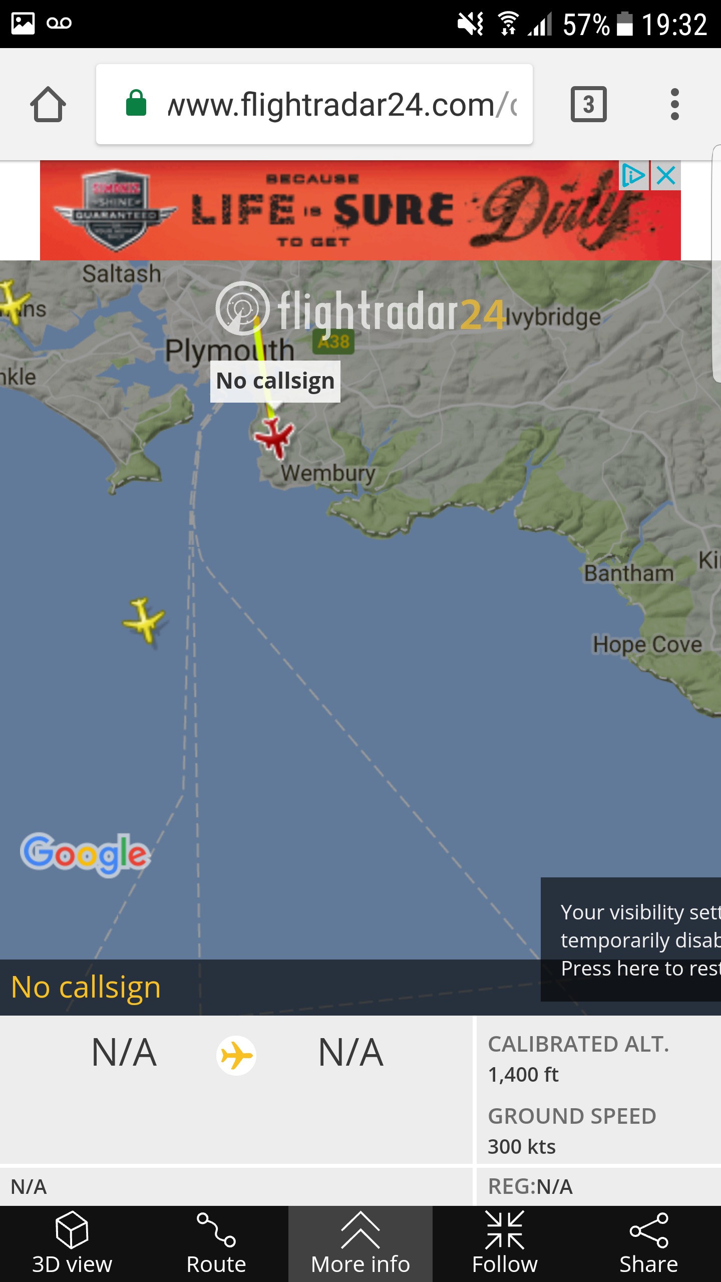
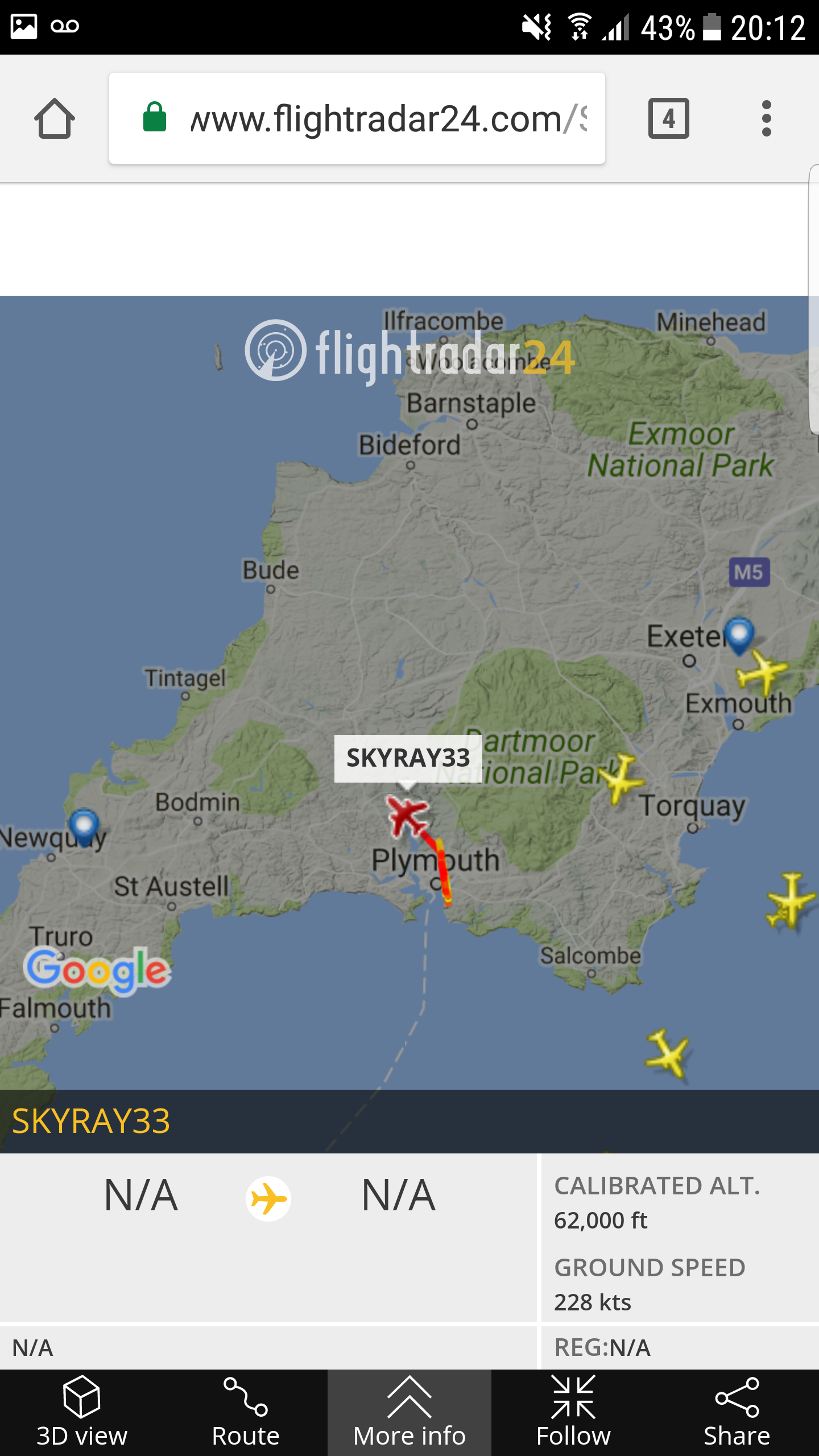
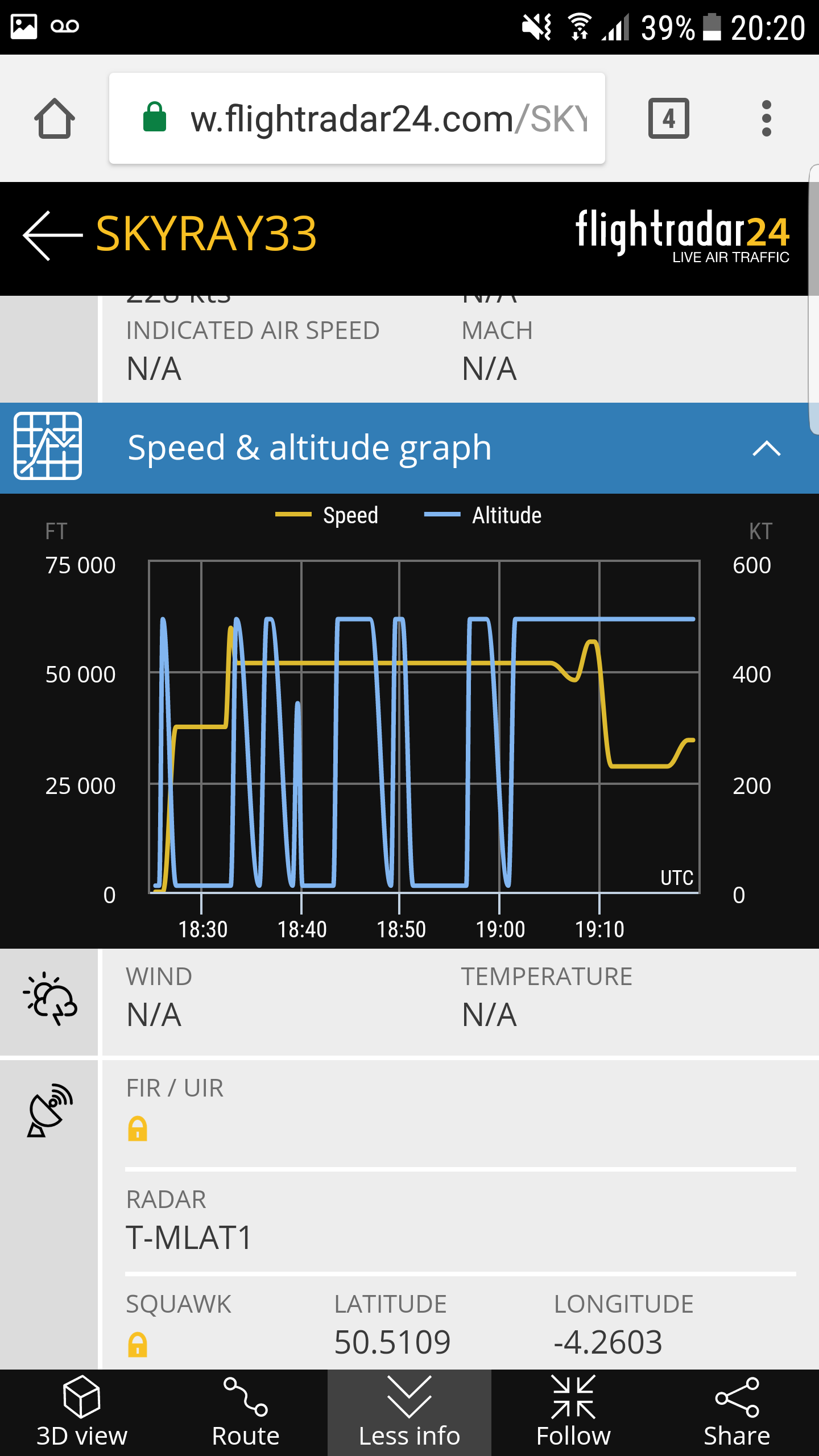
6-8 minutes going off flight radar I got a few screenshots


Its still over that area as of 20:15 this time there is a call sign though.

The altitude readings must be a glitch surely?
6-8 minutes going off flight radar I got a few screenshots

edit on 19-6-2017 by Woody510 because: (no reason given)

Its still over that area as of 20:15 this time there is a call sign though.
edit on 19-6-2017 by Woody510 because: Extra information

The altitude readings must be a glitch surely?
edit on 19-6-2017 by Woody510 because: (no reason given)
originally posted by: Zaphod58
a reply to: GuidedKill
There's a large military presence in that area. It could be a P-3 out of Jacksonville, or a T-45 on a test hop, or several other military types that fly out of that area.
The aircraft he saw was moving at 134 knots. That would point to a powered aircraft, not a balloon.
Is it possible that the craft in question caught a really fast jet stream? I know when I have flown private we would sometimes catch a fast East and West jet stream that would cut down on the travel time..
The Boeing 777-200 jet reached a ground speed of 745mph as it rode winds of more than 200mph across the Atlantic. At ground level, the speed of sound is 761mph.
LINK
a reply to: GuidedKill
No, when I saw it, they were going in a straight line heading northwest. If they had caught a wind, they'd be going east.
No, when I saw it, they were going in a straight line heading northwest. If they had caught a wind, they'd be going east.
a reply to: CulturalResilience
Access to the ocean without having to pass through the busiest parts of the airspace. If it's a UAV they have all kinds of special provisions in place to fly in busy airspace.
Access to the ocean without having to pass through the busiest parts of the airspace. If it's a UAV they have all kinds of special provisions in place to fly in busy airspace.
Most airliners etc fly at about 40 to 50,000ft dont they?62,000ft and 400+ knots seems out of the ordinary.
a reply to: Woody510
Might be the receivers in the area. These sites rely on people building and running ground stations out of their homes. That's why I thought it was a data glitch at first. They fly into a hole between receivers, or out of coverage of a receiver and the data goes weird for a few seconds.
Might be the receivers in the area. These sites rely on people building and running ground stations out of their homes. That's why I thought it was a data glitch at first. They fly into a hole between receivers, or out of coverage of a receiver and the data goes weird for a few seconds.
a reply to: Woody510
The data is from the plane, but it needs a receiver connected to the Web to let us see it through the site that's tracking them.
The altitude they were at the other day when I saw it is right about the altitude that the Global Hawk/Triton flies at.
The data is from the plane, but it needs a receiver connected to the Web to let us see it through the site that's tracking them.
The altitude they were at the other day when I saw it is right about the altitude that the Global Hawk/Triton flies at.
I don't just see triangles, sorry about that....I was being too brief in the details....
I see B2 cousins too.....they're not a B2 exactly....up there at 62,000 MSL....
They have the same points on the trailing edge but more symmetrical, so the wing has no high aspect tip sections
Cousin....to the B2....slick as hail looking....slips so fast going by ( no lights ).....to expound a little I use a johnny seven oma super duper triple snooper gen 3
edit on 19-6-2017 by GBP/JPY because: Gen 3 starlight that is.....a PVS14
a reply to: stratsys-sws
That was an F4D if I remember rightly. I'm sort of going with Zaph that it's a naval drone being tested especially with it being in Plymouth.
That was an F4D if I remember rightly. I'm sort of going with Zaph that it's a naval drone being tested especially with it being in Plymouth.
new topics
-
Orange County Makes Shoplifting a Felony
Other Current Events: 2 hours ago -
It's Offical Now
US Political Madness: 4 hours ago -
The reason it works is.....
General Chit Chat: 5 hours ago -
Dick Van Dyke saved from Wildfire by neighbours on his 99th birthday
People: 8 hours ago
top topics
-
It's Offical Now
US Political Madness: 4 hours ago, 9 flags -
Orange County Makes Shoplifting a Felony
Other Current Events: 2 hours ago, 9 flags -
The reason it works is.....
General Chit Chat: 5 hours ago, 6 flags -
Dick Van Dyke saved from Wildfire by neighbours on his 99th birthday
People: 8 hours ago, 3 flags
active topics
-
-@TH3WH17ERABB17- -Q- ---TIME TO SHOW THE WORLD--- -Part- --44--
Dissecting Disinformation • 3810 • : 777Vader -
Orange County Makes Shoplifting a Felony
Other Current Events • 11 • : yeahright -
It's Offical Now
US Political Madness • 8 • : xuenchen -
Post A Funny (T&C Friendly) Pic Part IV: The LOL awakens!
General Chit Chat • 7953 • : underpass61 -
Dick Van Dyke saved from Wildfire by neighbours on his 99th birthday
People • 1 • : soulrevival -
The reason it works is.....
General Chit Chat • 3 • : BeyondKnowledge3 -
London Christmas Market BANS Word ‘Christmas’
Social Issues and Civil Unrest • 44 • : Oldcarpy2 -
The Acronym Game .. Pt.4
General Chit Chat • 1024 • : JJproductions -
Christmas Dinner ??
Food and Cooking • 17 • : putnam6 -
1 Billion dollars
General Entertainment • 12 • : Blueracer

