It looks like you're using an Ad Blocker.
Please white-list or disable AboveTopSecret.com in your ad-blocking tool.
Thank you.
Some features of ATS will be disabled while you continue to use an ad-blocker.
share:
further to: muzzy
Another case of (RIS) Reservoir Induced Seismicity?
5.7 in Kiziloz-Samsat, Adiyaman Province, Turkey
Ataturk Baraj Golu (Ataturk Reservoir)
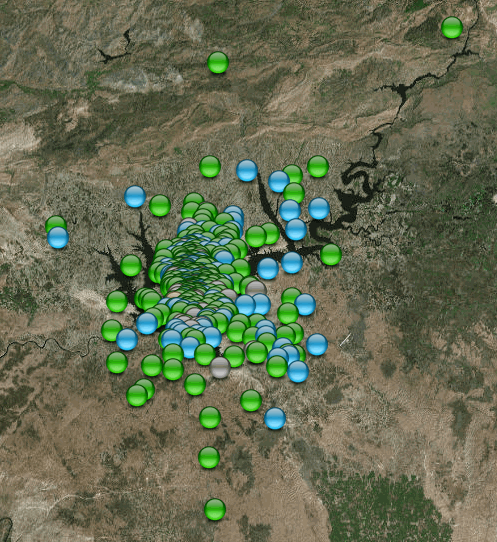
Adiyaman 5.7 quake and aftershocks
Link about the Dam
en.wikipedia.org...
I noticed this on the GFZ list on the day it happened,had a look on their map to see where it was, but didn't look on KOERI as I was more interested in the Canakkale Swarm, had no idea there were so many aftershocks to this.
5.7 is a decent sized event, especially in Turkey. I bet the Authorities there raised an eyebrow or two.
Another case of (RIS) Reservoir Induced Seismicity?
5.7 in Kiziloz-Samsat, Adiyaman Province, Turkey
Ataturk Baraj Golu (Ataturk Reservoir)

Adiyaman 5.7 quake and aftershocks
Link about the Dam
en.wikipedia.org...
I noticed this on the GFZ list on the day it happened,had a look on their map to see where it was, but didn't look on KOERI as I was more interested in the Canakkale Swarm, had no idea there were so many aftershocks to this.
5.7 is a decent sized event, especially in Turkey. I bet the Authorities there raised an eyebrow or two.
edit on 03000000707017 by muzzy
because: stuffed up the link, fixed it now
edit on 03000000707017 by muzzy because: add screenshot
further to: muzzy
The tremors here pretty much died away from 08/03/2017 03:09:55JST and all was quiet for 9hrs48min
one more (a M0.6) at 08/03/2017 12:58:46JST, then another break of 4hrs 5min to 08/03/2017 17:04:08JST before the swarm took off again in the east direction into Tokushima Pref. and did a 54 event 54hr 32min 21 second dance there, suddenly ending at 10/03/2017 23:36:29JST.
I made an animation of this sudden move
the image with the blue line is the first part in NE Ehime Pref, the blue line is scaled at 100km for reference
the second image is the Tokushima Pref later part added in
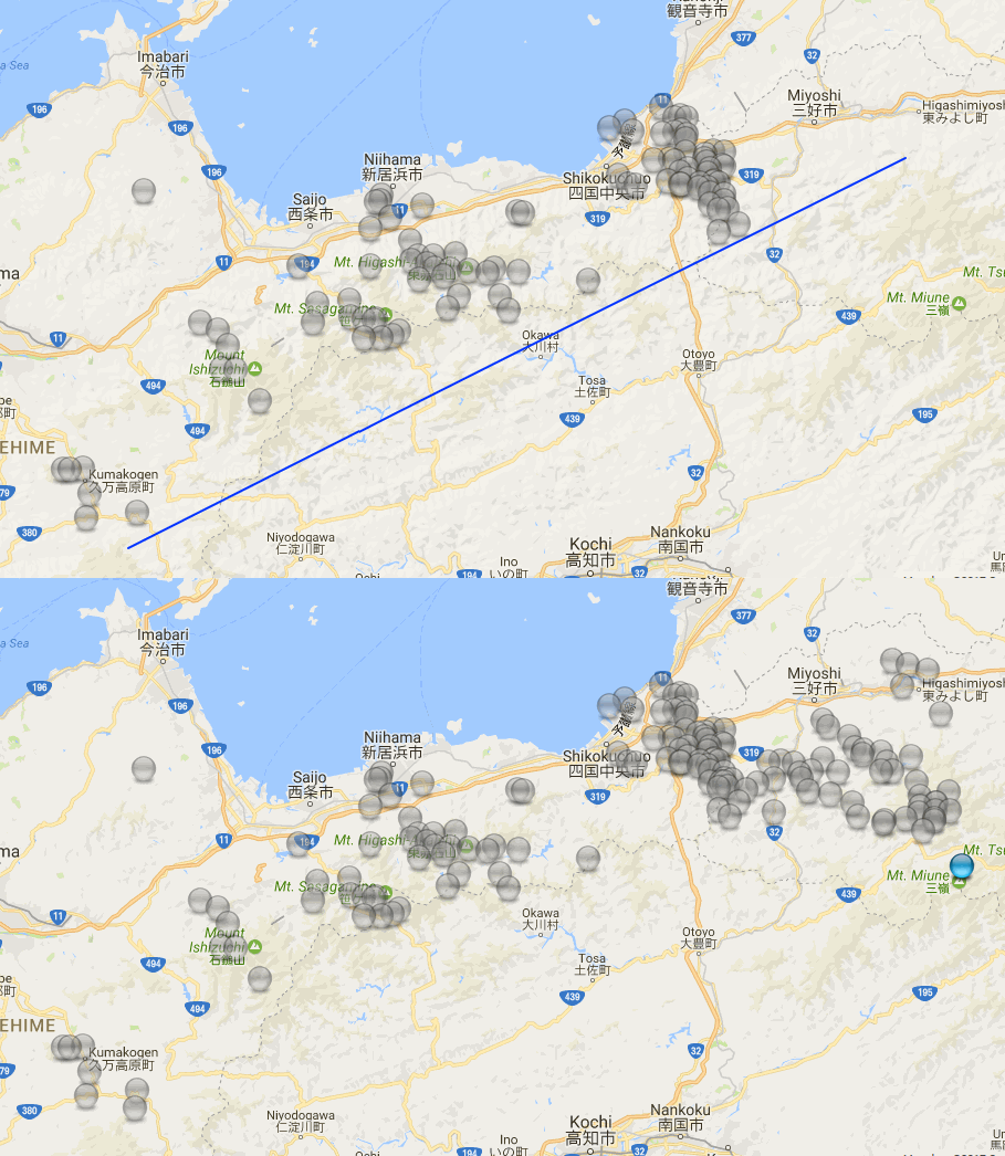
I wasn't able to exactly duplicate the blue line on the second image.
Maybe tomorrow I will break this swarm down into 24hr periods (its been going for 9 days now,) and put a proper scale on it.
I want to see if these worked their way progressively east right from the start or was it pretty random.
As usual, the more data available the more questions arise.
The tremors here pretty much died away from 08/03/2017 03:09:55JST and all was quiet for 9hrs48min
one more (a M0.6) at 08/03/2017 12:58:46JST, then another break of 4hrs 5min to 08/03/2017 17:04:08JST before the swarm took off again in the east direction into Tokushima Pref. and did a 54 event 54hr 32min 21 second dance there, suddenly ending at 10/03/2017 23:36:29JST.
I made an animation of this sudden move
the image with the blue line is the first part in NE Ehime Pref, the blue line is scaled at 100km for reference
the second image is the Tokushima Pref later part added in

I wasn't able to exactly duplicate the blue line on the second image.
Maybe tomorrow I will break this swarm down into 24hr periods (its been going for 9 days now,) and put a proper scale on it.
I want to see if these worked their way progressively east right from the start or was it pretty random.
As usual, the more data available the more questions arise.
edit on 03000000717117 by muzzy because: (no reason given)
Eric Blair is George Orwell's pen name. The funny thing is, I just looked up the word pen name to find out if it was hyphenated. And guess who's name
I saw at the top of the google search.
www.quora.com...
I'm only going to make one comment about fake news. READ GEORGE ORWELL.
So says Eric Blair.
The other day, I was going to declare the Northern Nevada swarm officially over. Every time I think it's over, it comes back, and it is with us again today. I am like Micheal Corleone; every time he thought he had become legit and grew passed the mafia, sbut they keep pulling him back in. I read Muzzy's post about B.C. and Washington State being busy, so, I will want to add that around Yellowstone things have picked up slightly. It was super quiet, so, anything at all is an uptick. I wouldn't find much to wonder about except there seems to be a clustering again. Near Challis Idaho too. I bet the next place to pick up is Norris. You watch. They'll be a swarm any day now.
Okay, that's all. I don't see much else too interesting except maybe NMSZ. It had slowed up, but now is back to a drip, drip state of being. It's not nothing, but I don't think it's something to worry about, just watching an noting.
Oh, and I've been a good boy and not ranted about fracking much. However, I must now tell you to watch for a giant increase as laws and regulation fall by the wayside. Good luck America. You idiots.
edit on 13-3-2017 by ericblair4891 because: (no reason given)
I'm surprised no one has mentioned the 3.6M on the Mississippi. The was a 2.6M as well. I mentioned the NMSZ the other day, and now I'm even more
curious. There have been 12 small earthquakes along the NMSZ, and they just grew in size as well as numbers. I'm not saying it's something. It's just
that it's not nothing. I was going post a picture, but I'll just let this go unless more stuff happens really soon. Otherwise, it seems quietishy.
a reply to: ericblair4891
Hi Eric!
I've been paying close attention because our oldest daughter, son-in-law & three of the grandkids are leaving tomorrow, driving to Texas. They are stopping in Kentucky, Tennessee, Texas, Oklahoma, & Illinois. I told the grandkids to pay attention so they can experience a quake!
They laugh at me & my interest in quakes!
Our youngest son & wife moved to Texas in July & felt the 5.something in Oklahoma a few months ago. So I made them a quake detector out of a big, free swinging, fishing sinker! Ha, ha!
They are going to watch the Golden State Warriors play Oklahoma City Thunder!
There may be some other 'shaking' going on!
Virginia had one the other day too. Was trying to remember which place used to echo Virginia, or was it Virginia echoing? It's been awhile since it's happened. Was it Nevada or Colorado? Can't remember now, having a senior moment! Been having a few of those lately!
NMSZ, tornado alley...I'll be glad when they are back home in good old boring PA!
WOQ
further to: muzzy
I had a few attempts at this, wasn't happy with the result using magnitude icons, in the end I went for the PNSN style where they have a rainbow key based on time. I just used the "default waypoint color menu" available on GPS Visualizer, it worked the best on the terrain map. It has 24 colours, so if I made more of these the timeline would be restricted to 24 days. Although you can use any HTML colour you want to, but it would probably get too complicated distinguishing between like coloured colours.
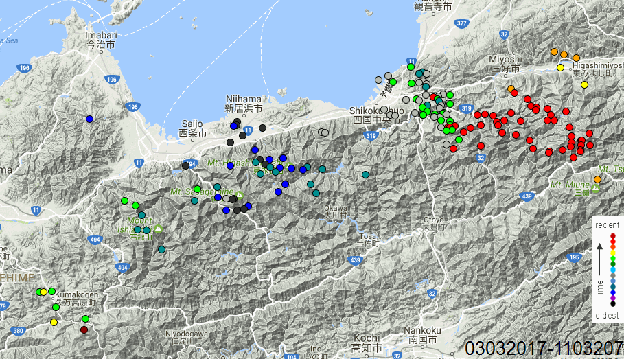
animation
I had a few attempts at this, wasn't happy with the result using magnitude icons, in the end I went for the PNSN style where they have a rainbow key based on time. I just used the "default waypoint color menu" available on GPS Visualizer, it worked the best on the terrain map. It has 24 colours, so if I made more of these the timeline would be restricted to 24 days. Although you can use any HTML colour you want to, but it would probably get too complicated distinguishing between like coloured colours.

animation
Yesterday:
Date and Time
UTC: 19 March 2017 @ 01:38:42
Location S of Mt Gambier, SA (Reported felt).
Coordinates: -38.078, 140.802
Depth: 10 km
Magnitude
ML: 3.1
Solution status
Last updated: 20 March 2017 @ 12:14:53 (AEDT)
Solution reviewed: Yes
Source: AUST
www.ga.gov.au...
Date and Time
UTC: 19 March 2017 @ 09:20:08
Location Beacon, WA.
Coordinates: -30.420, 117.786
Depth: 10 km
Magnitude
ML: 3.0
Solution status
Last updated: 20 March 2017 @ 13:58:20 (AEDT)
Solution reviewed: Yes
Source: AUST
www.ga.gov.au...
Date and Time
UTC: 19 March 2017 @ 01:38:42
Location S of Mt Gambier, SA (Reported felt).
Coordinates: -38.078, 140.802
Depth: 10 km
Magnitude
ML: 3.1
Solution status
Last updated: 20 March 2017 @ 12:14:53 (AEDT)
Solution reviewed: Yes
Source: AUST
www.ga.gov.au...
Date and Time
UTC: 19 March 2017 @ 09:20:08
Location Beacon, WA.
Coordinates: -30.420, 117.786
Depth: 10 km
Magnitude
ML: 3.0
Solution status
Last updated: 20 March 2017 @ 13:58:20 (AEDT)
Solution reviewed: Yes
Source: AUST
www.ga.gov.au...
Pretty quiet out there?
Always something going on in Japan though.
I had a look at this area, noticed higher numbers on the NIED lists for "Satsuma Peninsula"
A series of small-micro earthquakes occurred in late Feb- mid March 2017 on the east coast of the Satsuma Peninsula, Kyushu, Japan.
The main cluster was in Kagoshima Bay, with two smaller clusters at Sesekushi and Nukumi
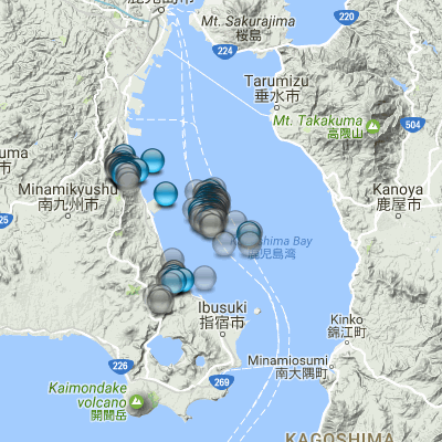
Did a page on it on japanquakes.blogspot.co.nz...
Nothing to be alarmed about. But interesting none the less.
Always something going on in Japan though.
I had a look at this area, noticed higher numbers on the NIED lists for "Satsuma Peninsula"
A series of small-micro earthquakes occurred in late Feb- mid March 2017 on the east coast of the Satsuma Peninsula, Kyushu, Japan.
The main cluster was in Kagoshima Bay, with two smaller clusters at Sesekushi and Nukumi

Did a page on it on japanquakes.blogspot.co.nz...
Nothing to be alarmed about. But interesting none the less.
a reply to: wasobservingquietly
I believe it was Colorado. We just had another little one in Virginia this morning, I didn't feel either of the recent two.
I believe it was Colorado. We just had another little one in Virginia this morning, I didn't feel either of the recent two.
a reply to: muzzy
Yep! Noticed that when I looked at Useless.
Nothing moderate in around 15 hours. It's happened before, but still gets my attention.
But it seems volcanic activity is still going on.
Just read another article about Alaska's Bogoslof.
It has erupted 36 times in the last 4 months & tripled in area. Kilauea has been erupting & was it Etna in Italy too?
There are a few places on the U.S. quake list today, that have had multiple small quakes & have hot springs in their name, plus Yellowstone. Just one of those things that make me go hmmm....
WOQ
a reply to: MnorthVA
Thanks. I missed the other ones!
I have noticed that while an odd one here or there isn't too unusual, so often they happen in multiple nearby states at the same time.
Makes me wonder what the catalyst is!
And while Oklahoma usually has some pretty much every day...there weren't any while the family was there! Go figure!!!
WOQ
Felt this one just now, very close
Public ID 2017p219803
Intensity moderate
Universal Time March 23 2017, 7:51:51
NZ Daylight Time Thu, Mar 23 2017, 8:51:51 pm
Depth 51 km
Magnitude 4.8
Location 10 km south-west of Paraparaumu
Latitude, Longitude -41.00, 174.90
www.geonet.org.nz...
6467 felt reports by the time I got to the page!
Public ID 2017p219803
Intensity moderate
Universal Time March 23 2017, 7:51:51
NZ Daylight Time Thu, Mar 23 2017, 8:51:51 pm
Depth 51 km
Magnitude 4.8
Location 10 km south-west of Paraparaumu
Latitude, Longitude -41.00, 174.90
www.geonet.org.nz...
6467 felt reports by the time I got to the page!
Few more over the past two days:
Date and Time
UTC: 26 March 2017 @ 07:53:54
Location Near Oodnadatta, SA.
Coordinates: -27.463, 135.271
Depth: 10 km
Magnitude
ML: 3.5
Solution status
Last updated: 27 March 2017 @ 13:14:33 (AEDT)
Solution reviewed: Yes
Source: AUST
www.ga.gov.au...
Date and Time
UTC: 26 March 2017 @ 20:00:03
Location NE of Norseman, WA. (Reported felt).
Coordinates: -31.616, 122.891
Depth: 10 km
Magnitude
ML: 3.7
Solution status
Last updated: 27 March 2017 @ 14:32:49 (AEDT)
Solution reviewed: Yes
Source: AUST
www.ga.gov.au...
Date and Time
UTC: 26 March 2017 @ 20:25:54
Location NE of Norseman, WA.
Coordinates: -31.794, 122.814
Depth: 10 km
Magnitude
ML: 3.2
Solution status
Last updated: 27 March 2017 @ 13:58:44 (AEDT)
Solution reviewed: Yes
Source: AUST
www.ga.gov.au...
Date and Time
UTC: 26 March 2017 @ 07:53:54
Location Near Oodnadatta, SA.
Coordinates: -27.463, 135.271
Depth: 10 km
Magnitude
ML: 3.5
Solution status
Last updated: 27 March 2017 @ 13:14:33 (AEDT)
Solution reviewed: Yes
Source: AUST
www.ga.gov.au...
Date and Time
UTC: 26 March 2017 @ 20:00:03
Location NE of Norseman, WA. (Reported felt).
Coordinates: -31.616, 122.891
Depth: 10 km
Magnitude
ML: 3.7
Solution status
Last updated: 27 March 2017 @ 14:32:49 (AEDT)
Solution reviewed: Yes
Source: AUST
www.ga.gov.au...
Date and Time
UTC: 26 March 2017 @ 20:25:54
Location NE of Norseman, WA.
Coordinates: -31.794, 122.814
Depth: 10 km
Magnitude
ML: 3.2
Solution status
Last updated: 27 March 2017 @ 13:58:44 (AEDT)
Solution reviewed: Yes
Source: AUST
www.ga.gov.au...
F-E Region: Near East Coast of Kamchatka
Time: 2017-03-29 04:09:23.5 UTC
Magnitude: 6.6
Epicenter: 162.64°E 56.97°N
Depth: 10 km
Status: C - confirmed
geofon.gfz-potsdam.de...
Time: 2017-03-29 04:09:23.5 UTC
Magnitude: 6.6
Epicenter: 162.64°E 56.97°N
Depth: 10 km
Status: C - confirmed
geofon.gfz-potsdam.de...
Quake watchers weigh in on the mystery tsunami in Iran here:
www.abovetopsecret.com...
Be curious as to your opinions.
www.abovetopsecret.com...
Be curious as to your opinions.
a reply to: TrueAmerican
I replied, with some evidence to back the Storm story.
Unlike the Mirror, which provided few details or facts.
I replied, with some evidence to back the Storm story.
Unlike the Mirror, which provided few details or facts.
a reply to: TrueAmerican
It did not come 'roaring in' as a tsunami would. It came creeping in such that it could be outrun I think.
That is a storm surge due to the geography of the region. It acted just as storm surge should.
P
It did not come 'roaring in' as a tsunami would. It came creeping in such that it could be outrun I think.
That is a storm surge due to the geography of the region. It acted just as storm surge should.
P
edit on 30/3/2017 by pheonix358 because: (no reason given)
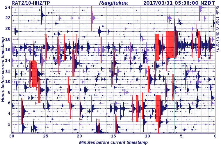
The Kuharau, Taupo Swarm that started on Feb 18th 2017 has kicked back on again with a vengence
Just processing the data now, I haven't looked at NZ earthquakes since the 27th, been too busy at work and too tired to even open the laptop in the evenings.
The 2 biggest quakes in the current disturbence
Public ID 2017p237835
Intensity strong
Universal Time March 29 2017, 23:58:49
NZ Daylight Time Thu, Mar 30 2017, 12:58:49 pm
Depth 6 km
Magnitude 4.5
Location 15 km north-west of Turangi
Latitude, Longitude -38.93, 175.67
www.geonet.org.nz...
Public ID 2017p239183
Intensity moderate
Universal Time March 30 2017, 11:57:13
NZ Daylight Time Fri, Mar 31 2017, 12:57:13 am
Depth 8 km
Magnitude 3.5
Location 15 km north-west of Turangi
Latitude, Longitude -38.94, 175.67
www.geonet.org.nz...
my page on the original Swarm
I will update it this morning.
Looking at Geonets map/stats page it appears the latest visitation is on the SW of the old volcano cone
here is the RATZ siesmo

edit on 03000000888817 by muzzy because: (no reason given)
a reply to: muzzy
WTF? I posted that just an hour and 10 minutes ago!
Come on ATS get your chit together!
Anyway, the Kuharau page has been updated now.
Three new timeline graphs and another map.
I split it into Part One (Feb18th-13thMarch) and Part Two (14thMarch on)
When you look at the latest events, it raises the question.............
when does a swarm cease to become a swarm and become foreshocks/mainshock/aftershocks?
I dunno.
You can see on the new graphs that up until the 4.5 it was still a swarm, with multiple M3's of varying decimal point sizes
But with the last set of M3's and the M4.5 you can see the spilling dots/track typical of a mainshock/aftershock graph
You have exceeded the maximum window of 4 hours allowed to edit your post.
WTF? I posted that just an hour and 10 minutes ago!
Come on ATS get your chit together!
Anyway, the Kuharau page has been updated now.
Three new timeline graphs and another map.
I split it into Part One (Feb18th-13thMarch) and Part Two (14thMarch on)
When you look at the latest events, it raises the question.............
when does a swarm cease to become a swarm and become foreshocks/mainshock/aftershocks?
I dunno.
You can see on the new graphs that up until the 4.5 it was still a swarm, with multiple M3's of varying decimal point sizes
But with the last set of M3's and the M4.5 you can see the spilling dots/track typical of a mainshock/aftershock graph
edit on 03000000888817
by muzzy because: (no reason given)
further to: muzzy
Kuharau, Taupo Swarm Part Two (14/3 to 02/4/2017) has been added to the page I did on the 31st March
link
2 new animations, by 24hrs and cumulative
I had to use Google Terrain for the 2nd animation as GPS Visualiser is now requiring an API key to view OSM TF maps.
its probably OSM that is doing this, but I can't understand why, OSM stands for OPEN Street Maps,
it is supposed to be OPEN SOURCE!
I have never had any luck getting an API key from Google, not sure why they won't give me one.
The OSM API key restriction now applies to;
OSM TF landscape (the one I used for the 1st animation)
OSM TF outdoors
OSM TF neighbourhood
OpenCycleMap (TF) was good for showing topography without too much junk on it
WorldPublicTransit (TF) was good for clean maps without too much colour
Google Terrain is OK, but when making an animation the background colors on some individual image screenshots change as there are so many shades of colour, and that can make the animation "lumpy"
edit on 04000000909017 by muzzy because: (no reason given)
edit on 04000000909017 by muzzy because: (no reason given)
new topics
-
Watching TV
Jokes, Puns, & Pranks: 6 minutes ago -
RFK is Trumps health pick
2024 Elections: 8 hours ago
top topics
-
The art of being offended
Social Issues and Civil Unrest: 16 hours ago, 20 flags -
FLORIDA Sues Biden-Harris FEMA for Denying Disaster Assistance to Homeowners with TRUMP Signs.
US Political Madness: 17 hours ago, 15 flags -
Thanksgiving 2024
Member Art: 14 hours ago, 13 flags -
RFK is Trumps health pick
2024 Elections: 8 hours ago, 12 flags -
Watching TV
Jokes, Puns, & Pranks: 6 minutes ago, 0 flags
active topics
-
The art of being offended
Social Issues and Civil Unrest • 34 • : Dandandat3 -
Mike Tyson returns 11-15-24
World Sports • 32 • : Encia22 -
President-elect TRUMP Picks MATT GAETZ for his ATTORNEY GENERAL - High Level PANIC Ensues.
2024 Elections • 73 • : marg6043 -
Watching TV
Jokes, Puns, & Pranks • 0 • : DAVID64 -
Thanksgiving 2024
Member Art • 17 • : Flyingclaydisk -
Judge’s Dismissal of Classified Document Case Against Trump Explained
Other Current Events • 25 • : UKTruth -
Alex Jones Reinstated on X
Education and Media • 85 • : NoCorruptionAllowed -
FLORIDA Sues Biden-Harris FEMA for Denying Disaster Assistance to Homeowners with TRUMP Signs.
US Political Madness • 38 • : Flyingclaydisk -
Nephilim looked like clowns
Conspiracies in Religions • 37 • : andy06shake -
US warship Edsall Lost after Pearl Harbor Attack Found 80 Years Later ... by Accident
Mainstream News • 13 • : andy06shake
