It looks like you're using an Ad Blocker.
Please white-list or disable AboveTopSecret.com in your ad-blocking tool.
Thank you.
Some features of ATS will be disabled while you continue to use an ad-blocker.
share:
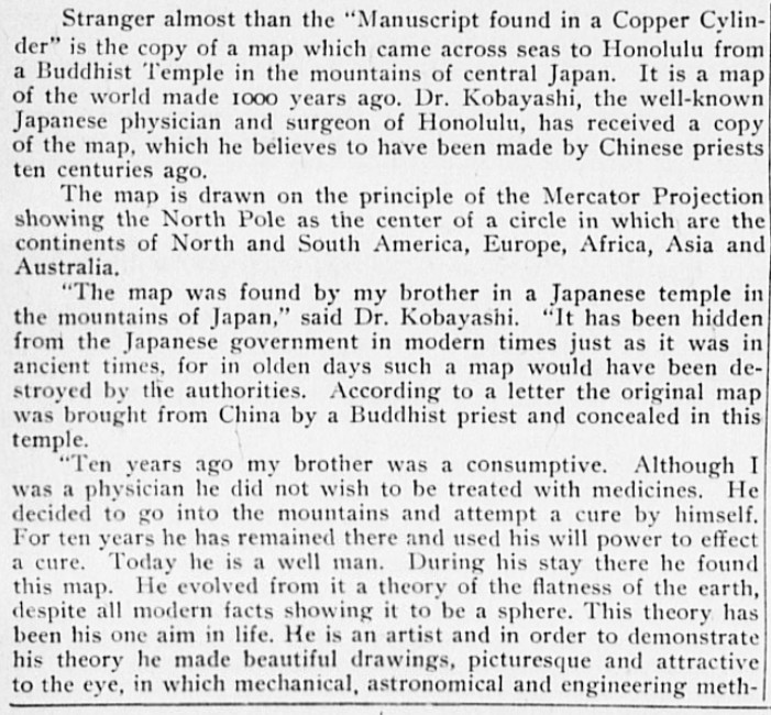
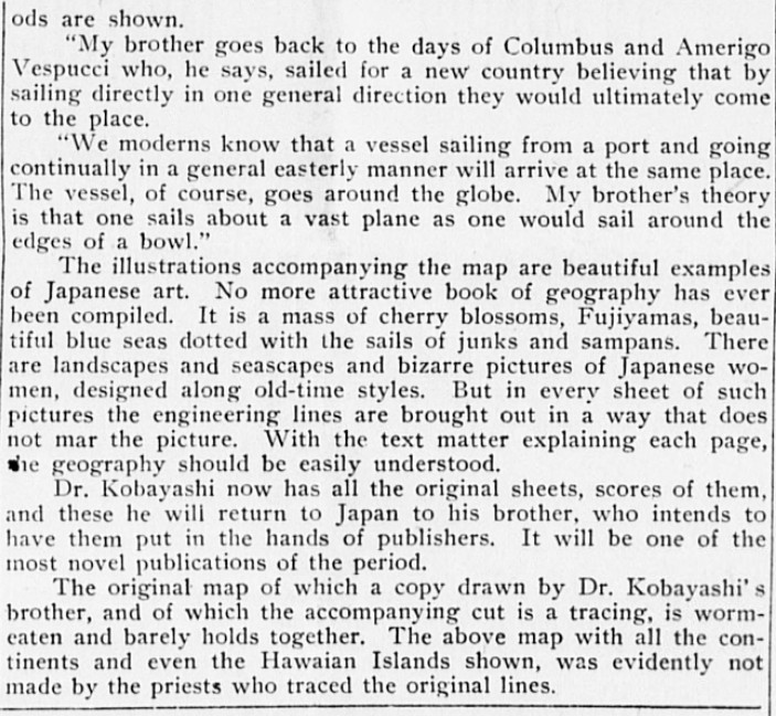
From the Hawaiian Gazette, Friday, January 11, 1907
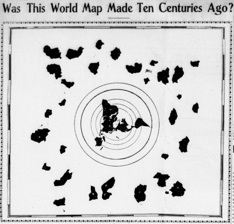
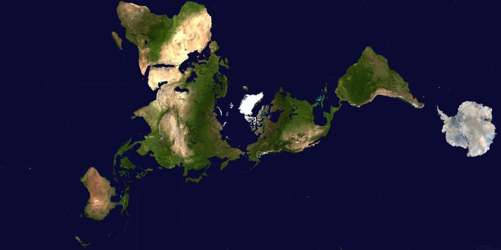
This map is very interesting because it is very similar to a Dymaxion/Fuller Projection Map not invented until the 1940's by Buckminster Fuller except it shows much more land which is not visible on other world maps.
Dymaxion/Fuller Projection Map

Back to the news article found with the map from the Hawaiian Gazette, Friday, January 11, 1907


A map that is claimed to be 1000 years old found in a newspaper from 1907 but the map wasn't invented until the 1940's.
Any ideas of what the extra land masses could be? Thoughts?
This Dr. Kobayashi's brother is a flat earther.....but interesting map similarities none the less.
ETA: In my opinion all the "extra" surrounding islands are all just Antarctica from every approach, they never realized it's the same landmass. Got too cold and turned back north.
ETA: In my opinion all the "extra" surrounding islands are all just Antarctica from every approach, they never realized it's the same landmass. Got too cold and turned back north.
edit on 11/23/2016 by jappee because: (no reason given)
The map was around way before 1940's. Cartography or map making, has been about for millennia. Interesting article none the less though.
a reply to: jappee
Always been intrigued by this map. Then again, I've always been intrigued by the possibility of a flat earth. What fascinates me is how Flat Earth is one of those few conspiracies that really gets people riled up. Even in real life when talking with friends, I can mention reptilians, UFO's, illuminati, and so on, but mentioning the potential for Earth to be flat and people truly go like: "Wait, how the # can u even entertain the idea?". On the internet, esp youtube and reddit, this is oftentimes associated with very agressive language. I'm not sure if it's arrogance, fear or whatever emotion that's causing this extreme lashing out at flatties, but it's definitely noticeable within the flat earth community.
I think what bothers me most is the sheer amount of pseudo-scientists claiming how easy it is to check for yourself the earth is round, oftentimes associated with invalid experiments. The amount of times I've seen someone say: "Omg you retards, just take a rules and measure the horizon. You're so stupid every retard can see there's a curve" is beyond count.
And the sad part is, people think it's justified. People think that because we have certain shadow patterns, because we explained gravity in our round model, clearly a flat earth would be impossible because you'dd just fall of the edge, hurr durr. When in reality, it's alot more complicated, if you're going to entertain the idea of a Flat Earth, it seems pretty evident that u can't just take every existing (proven) theory we have today and apply it to the Flat Earth without making adjustments. "Oh, planets are round, therefore earth is round. You're retarded for believing otherwise, mental instituation material."
Just had to vent my frustration. I'm a fan of all conspiracies (and freedom of speech without judgement), but I've long noticed how Flat Earth really gets picked out and bullied for no apparant reason. I've seen plenty of valid questions being raised, which I'm still intrigue by today. I'm still a globie, but u can be sure as hell I believe a flat earth could definitely be possible.
originally posted by: solarone
The map was around way before 1940's. Cartography or map making, has been about for millennia. Interesting article none the less though.
Not just any map. This style of map depicting from the north pole down. When were they invented? How would you invent a map like this even in 1907?
a reply to: gmoneystunt
Apologies, it appears I didn't read your post correctly. It's certainly intriguing.
Apologies, it appears I didn't read your post correctly. It's certainly intriguing.
a reply to: Vechthaan
I still fail to see the advantages of a flat earth compared to a round earth.
- Static/dynamic stability? What about statics, anyway?
- Single point of mass as a simplification in dynamical mechanics?
- What is on the other side?
- Where did the moon come from? If from Earth as established science tells us, and there was a major collision 4.000.000.000 years ago, how did the disc form, which mechanism was scaping this?
- What about gyratory effects on the outer zones of the disc? Is the disc spinning? Is the disc bowl-shaped?
- What about the magnetic North- and Southpole?
There are simply too many open questions and failed answers and totally inconsistendy misinterpreted effects for me to take the Flat Earth seriously.
a reply to: gmoneystunt
This map is just a bit of bad cartography. Very likely compiled from previous maps and inadvertently adding more masses than are really there. This is a common problem with other similar maps. What is intriguing is the supposed age. At a presumed 1000yo, it would indicate that early civilisation was much more experienced with sailing and navigation than is currently accepted.
The perry-reis map is another example of a map showing parts of the antarctic that were considered un explored at the time. It is also considered a compiled map but shows a fairly accurate depiction of the land underneath the ice as we have found with satelite and sonar.
Flat earth theories are ridiculed because of frustration, not fear. It really is quite easy for the average person to figure this out in their own back yard. For those less than average, they are left questioning this and many other fundemental aspects of reality.
Old maps are less accurate than new ones. This doesn't prove that there are more land masses in the antarctic. It only proves that their ancient knowledge of world geography was incomplete.
If you take a plane up to 40,000 ft there is no doubt that the earth is near spherical.
edit on 23-11-2016 by Woodcarver because: (no reason
given)
a reply to: ManFromEurope
Hmmm, Flat Earth....... Try this,
Suspend a bowling ball from a line.....Pull it back and let it go.
Watch what it does....... back and forth soon becomes round and round.....we are on a spinning Earth.
In a flat world the centrifugal force would push everything to the edge..... much like an object dropped on a spinning record. We would have evolved in to a society that affixes things to the floor.
Luckily for us the world is round....well not really round but that's another topic for another thread....... and Newtonian law works like a charm
originally posted by: [post=21562845]Vechthaan[/post
Then again, I've always been intrigued by the possibility of a flat earth. What fascinates me is how Flat Earth is one of those few conspiracies that really gets people riled up. Even in real life when talking with friends, I can mention reptilians, UFO's, illuminati, and so on, but mentioning the potential for Earth to be flat and people truly go like: "Wait, how the # can u even entertain the idea?"
Because we have overwhelming evidence that the Earth is not flat; it is round or round-ish. I have flown around the world in a plane (not non stop ofc), starting from London, going to Tokyo, then to LA, then to Ottawa, then to London. The Sun was always on my right, or there abouts.
. On the internet, esp youtube and reddit, this is oftentimes associated with very agressive language. I'm not sure if it's arrogance, fear or whatever emotion that's causing this extreme lashing out at flatties,
It's mostly anger at peoples' utter stupidity to believe the Earth is flat in 2016, with a hint of sorrow that such stupid, moronic human beings are still alive and spreading their DNA.
I think what bothers me most is the sheer amount of pseudo-scientists claiming how easy it is to check for yourself the earth is round
Really. So evidence-based processes are considered pseudo-science to you? Ok, how about something nice and simple for the idiot flat earthers to understand.
...but I've long noticed how Flat Earth really gets picked out and bullied for no apparant reason.
It isn't for 'no apparant[sic] reason' -- it's because the scientific, observable, *repeatable* evidence to a round Earth is so overwhelming, that to deny it shows either wilful ignorance or genuine mental retardation. That's why flat earthers are mocked and shamed.
a reply to: gmoneystunt
my ` first impressions ` - utter bollox
it screams HOAX lacking even an internally consistent backstory
and the acid test - what was the reaction of ANYONE to this ???
primary sources are the gold standard - but this tail has none - and only a single point " secondary source ` - which is of dubious provenance - the fact that such a " revelation " seems to have sunk without a single reaction - is the hoax confirmation
Was this world map made ten centuries ago
Has anyone carbon dated the paper it was made on?
originally posted by: o0oTOPCATo0o
originally posted by: jappee
ETA: In my opinion all the "extra" surrounding islands are all just Antarctica from every approach, they never realized it's the same landmass. Got too cold and turned back north.
My thoughts exactly
+2 on that as well!
I'm going with "hoax" from a Flat Earther of the 1900's. The map is wildly inaccurate, and is inconsistent with the way Japanese drew maps. The
"found by a relative in an ancient temple where it was hidden to protect it from government that would destroy it" is a common fiction told when
bringing out this kind of thing.
A real item would have included verifiable data. (the border decoration on the map is also not Chinese or Japanese or even Asian.)
I would believe, however, that it's a map someone painted inside a bowl.
A real item would have included verifiable data. (the border decoration on the map is also not Chinese or Japanese or even Asian.)
I would believe, however, that it's a map someone painted inside a bowl.
originally posted by: gmoneystunt
[url=https://en.wikipedia.org/wiki/Dymaxion_map]invented until the 1940's.
Any ideas of what the extra land masses could be? Thoughts?
I take my clue from the larger concentric rings around the globe...
these rings could depict Atmosphere or Gravity boundaries... making the various 'land masses' just stylized asteroids or space rocks..... Yeah, even in 1000 AD they knew about the heavens and meteorites & shooting stars
if the chartographers of that era, wanted to denote a south pole land/ice mass they could well have done just what Buckminister Fuller did... and string the ( then) unexplored Antarctica landmass to the right of the tip of south America just as in the lower map in full color
``````````
as far as this post:
originally posted by: gmoneystunt
Not just any map. This style of map depicting from the north pole down. When were they invented? How would you invent a map like this even in 1907?
Answer: world maps that shown of all the continents from a bird's-eye-view (looking down at N pole) have been around for all of human history, every king or village /war lord had such maps to plan their strategies in a real-world game of 'Risk' ~ global or local campaigns

if you unfocus your gaze... the landmasses of the map kinda resemble a Eagle landing with wings extended...
'the two wings of a great Eagle to be taken to a place of safety for 3 1/2 years?
with the nearby heavens jammed up with those rocks that will fall from heaven upon the men who have the mark-of-the-beast
edit on
rd30147992220523302016 by St Udio because: (no reason given)
I went on a real long flight once. I saw the sun set behind the plane, and I went to sleep. I think about six hours later the sun came up in front of
the plane. It was morning at my destination, but I kept thinking it was evening
Cool thread and very intriguins subject, the other lands mass are interesting but here is another possibilty about them, this could be based on a much
more ancient map that was correct and did not show those other land mass, as it was in the Buddhist possession it is possible that this older design
was then added to with land mass that were purely spiritual concept's, places were spirit's and other realm's of reality were believed to be,
alternatively as the Buddhist tradition does believe in reincarnation they may be meant to represent older time's, with the more modern world in the
center and older reality's radiating outward from it.
Better than the piri reis map though if it can be proven to be genuine and even more shaking for traditional belief in how advanced ancient cartography was and indeed if so also indicative of a far more advanced ancient civilization or culture than is accepted by the mainstream today.
Thank you for sharing and enlightening us with this.
The other 'land masses' are simply representations of their colonies on the other planetoids within the solar system.
new topics
-
Swarms of tiny 'ant-like' robots lift heavy objects and navigate obstacles
Science & Technology: 49 minutes ago -
NYPD Chief Jeffrey Maddrey Resigns - Forced Officers to Give Sex for Overtime Pay and Favors.
Posse Comitatus: 2 hours ago -
The Carpet Coating that Attacked the Environment
Medical Issues & Conspiracies: 6 hours ago -
Microplastics in your drinks
Medical Issues & Conspiracies: 7 hours ago
top topics
-
The Carpet Coating that Attacked the Environment
Medical Issues & Conspiracies: 6 hours ago, 11 flags -
China Working on 'Drone Mothership' Plane
Military Projects: 12 hours ago, 10 flags -
Microplastics in your drinks
Medical Issues & Conspiracies: 7 hours ago, 5 flags -
Happy Rush Day 2024 - 2112
Music: 12 hours ago, 4 flags -
12-21-24 Usyk-Fury II
World Sports: 15 hours ago, 1 flags -
NYPD Chief Jeffrey Maddrey Resigns - Forced Officers to Give Sex for Overtime Pay and Favors.
Posse Comitatus: 2 hours ago, 1 flags -
Swarms of tiny 'ant-like' robots lift heavy objects and navigate obstacles
Science & Technology: 49 minutes ago, 1 flags
active topics
-
Swarms of tiny 'ant-like' robots lift heavy objects and navigate obstacles
Science & Technology • 1 • : imitator -
An Interesting Conversation with ChatGPT
Science & Technology • 32 • : Sasquatch1111 -
Drones everywhere in New Jersey ---and Elsewhere Master Thread
Aliens and UFOs • 221 • : imitator -
Donald Trump Should Offer AMNESTY to the BIDEN FAMILY For Indicting Blackmailers-Controllers.
US Political Madness • 78 • : WeMustCare -
JOSEPH BIDEN Says Democrat Coup Leaders Forced Him to Resign the Presidency - Eff 1.20.2025.
2024 Elections • 55 • : WeMustCare -
Democrat Leader Hakeem Jeffries Promotes HATE After 2nd Attempt to Murder Trump in 2024.
US Political Madness • 41 • : WeMustCare -
Flying saucer spotted during the Trump assassination attempt
Aliens and UFOs • 66 • : WeMustCare -
Microplastics in your drinks
Medical Issues & Conspiracies • 13 • : WeMustCare -
NYPD Chief Jeffrey Maddrey Resigns - Forced Officers to Give Sex for Overtime Pay and Favors.
Posse Comitatus • 4 • : WeMustCare -
'Mass Casualty event' - Attack at Christmas market in Germany
Mainstream News • 136 • : 777Vader
