It looks like you're using an Ad Blocker.
Please white-list or disable AboveTopSecret.com in your ad-blocking tool.
Thank you.
Some features of ATS will be disabled while you continue to use an ad-blocker.
share:
a reply to: texasgirl
God forbid we have a direct hit coming (unless it's a long track F4/5 and we can safely speed away in advance) we will just hunker down in my pantry in the kitchen with us and the two dogs. Really our only interior closet.
Granted I'll have my wife in my plate carrier with steel plates and wearing my old Kevlar helmet LOL. Prolly cover up in some thick quilts too...
One of these days I'll have to join advance storm chase - on my bucket list, and just maaaaybe she'll let me go if I'm joining some very knowledgeable folks...


These are both older, but look at the energy showing up especially through the middle of Kansas. I'm glad I don't still live out in McPherson anymore.
edit on 25-4-2016 by ketsuko because: (no reason given)
@KOCOdamonlane -- Oklahoma: Schools are beginning to announce closures because of tomorrow's severe risk. Stay tuned...
a reply to: SonOfThor
This is what it is looking like..
Discrete powerful supercells will initiate (4pm-6pm)in western north Texas, roughly along a line of mineral wells to Gainesville, they will move in a north easterly direction, there may only be three or four powerful storms at first, these storms have a threat of all modes of severe weather including giant hail, and tornadoes, Ft worth (6pm-8pm) is under the gun for being impacted by these types of storms, they will congeal as they move into an easterly direction, forming a squall line (still very powerful) which will lower the tornado risk but non zero,there will be a large hail and damaging straight line wind threat, this squall line will effect those east of Denton through Dallas (7pm - 10pm), all this could change but that is the current thinking. It cannot be stressed enough just how unstable the atmosphere will be, so all storms will be severe and very powerful. Current thinking is that the ingredients are in place across the southern plain to Kansas for a wide spread damaging outbreak, stay tuned.
edit on
25-4-2016 by TechniXcality because: (no reason given)
Central Plains
THE STRENGTH OF THE LOW-LEVEL WINDS
IS THE PRIMARY FACTOR ANTICIPATED TO LIMIT HIGHER-END SEVERE
POTENTIAL -- I.E. NUMEROUS LONG-TRACK TORNADOES -- PRECLUDING THE
NEED FOR AN UPGRADE TO HIGH RISK WITH THIS FORECAST. THAT BEING
SAID...NUMEROUS SEVERE TSTMS ARE STILL ANTICIPATED WITH ALL SEVERE
THREATS POSSIBLE...INCLUDING VERY LARGE HAIL AND A STRONG TORNADO OR
TWO.
NOAA forecast for tuesday for central and southern plains.
Sounds like a rough day ahead.
edit on 4/25/2016 by roadgravel because: (no reason given)
NWS Discussion -
BETTER HEIGHT FALLS WILL OVERSPREAD THE SOUTHERN AND CENTRAL PLAINS TUESDAY AFTERNOON/EVENING...AS THE UPPER LOW/TROUGH MOVES ACROSS THE SOUTHERN PART OF THE GREAT PLAINS. A RATHER UNSTABLE AIRMASS WILL BE IN PLACE BY AFTERNOON WITH CAPE VALUES AROUND 3500-4000 J/KG PER 12Z NAM12. DANGEROUS STORMS ARE POSSIBLE...ESPECIALLY IF STORM DEVELOPMENT REMAINS ISOLATED TO WIDELY SCATTERED DURING THE LATE AFTERNOON-EARLY EVENING. IT`S POSSIBLE STORM MODE MAY BECOME QUICKLY LINEAR GIVEN THE TIMING OF THE WAVE AND LARGE-SCALE ASCENT. STORMS MAY FIRST DEVELOP TO THE WEST OF INTERSTATE 35 MAINLY ALONG AND EAST OF A CHEROKEE TO ANADARKO AND LAWTON LINE. STORM DEVELOP FARTHER WEST OR EAST IS CERTAINLY POSSIBLE. BOTTOM LINE...DANGEROUS STORMS ARE LIKELY TUESDAY AFTERNOON/EVENING...SO PLAN AHEAD.
Google map link deleted
Link does not play well here...
Link does not play well here...
edit on 4/25/2016 by roadgravel because: (no reason given)
Severe weather outbreak shareable graphic
Shareable image for social media so you can keep family informed.. not sure how to direct post image...
Shareable image for social media so you can keep family informed.. not sure how to direct post image...
a reply to: TechniXcality
Yikes - obviously the tornado threat is something to keep an eye on but honestly the huge hail threat is worrisome...
As we get closer to the event are there any meteorological indicators to pay attention to that can provide even more accurate forecasts?
Where do you plan to go chasing? I'm curious where the chasers think / estimate the strongest tornado threat is? (hopefully in an extremely rural area and no one loses their home, but nature is nature)...
Will be keeping an eye on this thread tonight and tomorrow especially.
Goes without saying, thanks for all your work on this! Highly appreciated by a lot of us here
a reply to: olaru12
Thank you.
The main weapon is always awareness. Odds are that everyone will be fine, but, of course, it just takes once to be in the wrong place at the wrong time. My parents are my main worry living rural like they do in an old pile of stone. They know what to do, of course, but it may not help much in such an old house.
Steve McCauley profession MET update ( he will update more this evening)
A weakness developed in the cap this afternoon over south Texas and allowed a couple of supercell thunderstorms with baseball-sized hail to rapidly fire south of San Antonio. This is evidence that our cap here in north Texas will likely break late tomorrow afternoon leading to explosive development of severe thunderstorms. The first to fire will be in the western portions of north Texas and then moving NE into the Metroplex during evening hours.
originally posted by: SonOfThor
a reply to: TechniXcality
Yikes - obviously the tornado threat is something to keep an eye on but honestly the huge hail threat is worrisome...
As we get closer to the event are there any meteorological indicators to pay attention to that can provide even more accurate forecasts?
I am watching the WRF TTU model & the NAM hires model both of which are showing upwards of 4K j/kg - 6k j/k across the area tomorrow!! the wrf is showing Ft Worth through collin county having a tornado risk, however that risk changes every model run.. So we are watching these models closely, and once we get to within twelve hours, two more models will have data and an even clearer picture.
Where do you plan to go chasing? I'm curious where the chasers think / estimate the strongest tornado threat is? (hopefully in an extremely rural area and no one loses their home, but nature is nature)...
I may not be able to chase tomorrow, however I would head west of Ft Worth and park around Mineral Wells and watch radar and follow the storms east.. The highest risk area for tornadoes (at this time) is west of I35 and north of I20 however anywhere north of I20 could see tornadoes, and giant hail (larger than grapefruit)
Will be keeping an eye on this thread tonight and tomorrow especially.
Goes without saying, thanks for all your work on this! Highly appreciated by a lot of us here
You are most certainly welcome and I'm glad that I have an avenue to give you guys a heads up in advance, stay tuned will continue to update.
a reply to: TechniXcality
I am also following this thread and just want to thank you for the info! Please keep us updated.
I am also following this thread and just want to thank you for the info! Please keep us updated.
Quick update..
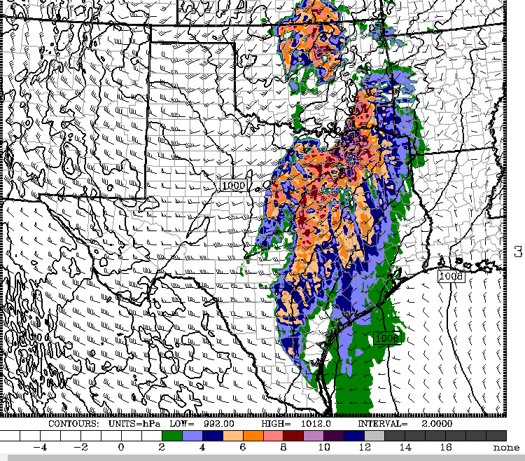
The latest WRF run is very concerning, just as significant tornado conditions are met, lone thunderstorms (supercells) will have formed over the DFW area, here is a model depiction showing the "significant tornado parameter" and it's values ( the oranges and purples are high values!)
Here is a depiction of isolated convection in the area at that time (8pm CDT)..
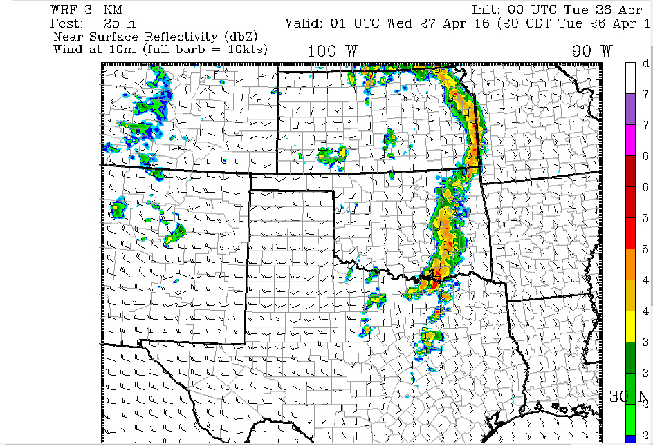
These storms will be very powerful and their isolated nature is very concerning as all the available instability will be used efficiently.
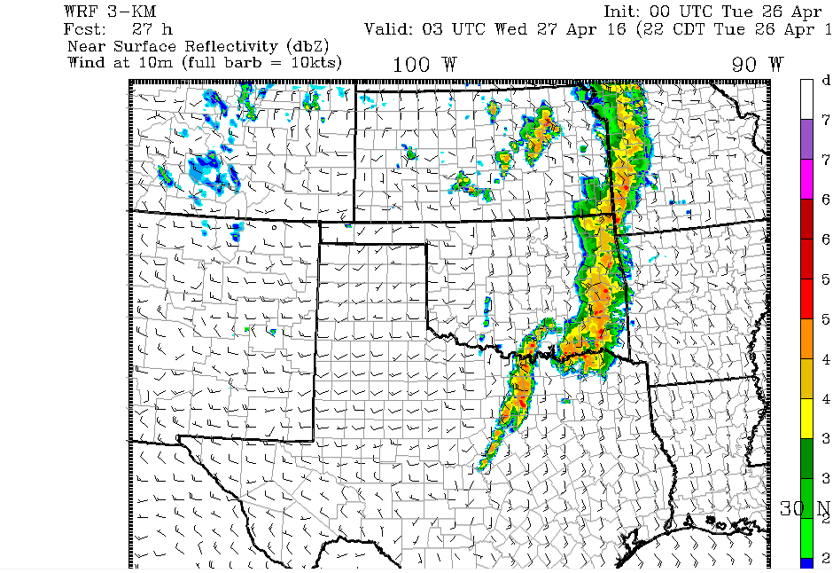
shortly after a squall line will form and by 10pm-11pm it will be in the heart of DFW here is a radar picture showing just that. (remember this is just one model depiction just within twenty four hours of the event, so please not take this as gold, but it is further evidence a potentially deadly and damaging severe outbreak will occur across the area tomorrow)
SPC has not issued a high risk yet, however I believe the first high risk will be issued tomorrow model data is looking ugly, everyone from north Texas to Kansas needs to be prepared, ( I primarily will focus on north Texas, NOT that others cannot or should not add to this thread as the events unfold, I simply cannot cover every area at once)
The latest WRF run is very concerning, just as significant tornado conditions are met, lone thunderstorms (supercells) will have formed over the DFW area, here is a model depiction showing the "significant tornado parameter" and it's values ( the oranges and purples are high values!)

Here is a depiction of isolated convection in the area at that time (8pm CDT)..

These storms will be very powerful and their isolated nature is very concerning as all the available instability will be used efficiently.
shortly after a squall line will form and by 10pm-11pm it will be in the heart of DFW here is a radar picture showing just that. (remember this is just one model depiction just within twenty four hours of the event, so please not take this as gold, but it is further evidence a potentially deadly and damaging severe outbreak will occur across the area tomorrow)

SPC has not issued a high risk yet, however I believe the first high risk will be issued tomorrow model data is looking ugly, everyone from north Texas to Kansas needs to be prepared, ( I primarily will focus on north Texas, NOT that others cannot or should not add to this thread as the events unfold, I simply cannot cover every area at once)
edit on 26-4-2016 by TechniXcality because: (no reason given)
edit on
26-4-2016 by TechniXcality because: (no reason given)
a reply to: TechniXcality
Just be careful while you're riding the storm out. I'd say to get what you need from the store ahead of the storm but I'm sure you've been through it before.
Just be careful while you're riding the storm out. I'd say to get what you need from the store ahead of the storm but I'm sure you've been through it before.
NWS discussion
POTENTIAL OF A SIGNIFICANT SEVERE WEATHER DAY ACROSS THE AREA. THE PRIMARY TAKEAWAY IS THAT ALTHOUGH THERE ARE SOME UNCERTAINTIES DISCUSSED BELOW... RESIDENTS OF OKLAHOMA AND NORTH TEXAS SHOULD REMAIN ALERT TODAY FOR THE POTENTIAL OF SEVERE WEATHER AND TORNADOES AND SHOULD NOT FOCUS ON THE MINUTIA OF THE MORE UNCERTAIN TIMING AND EVOLUTION DETAILS OF THE FORECAST. ON THE LARGE SCALE... THE AIRMASS OVER THE AREA WILL BECOME VERY UNSTABLE AND THE PRIMARY UPPER WAVE IS PROGGED TO APPROACH WESTERN OKLAHOMA AT 00Z... WELL TIMED FOR STORM DEVELOPMENT LATE THIS AFTERNOON AND EVENING. THE INSTABILITY WILL DEFINITELY SUPPORT HIGH-END SEVERE STORMS WITH VERY LARGE HAIL. SEVERE STORM DEVELOPMENT IS LIKELY THIS AFTERNOON/EVENING. BUT THE DEVIL IS IN THE DETAILS AND A NUMBER OF QUESTIONS REMAIN ABOUT SPECIFIC EVOLUTIONS. FIRST IS TIMING. ALTHOUGH TIMING OF THE MAIN WAVE LOOKS REASONABLE... SATELLITE HAS SHOWN MID/HIGH CLOUDS DEVELOPING FROM EL PASO NORTHEAST TOWARD GUYMON HINTING AT A FEATURE THAT DOES NOT APPEAR TO BE RESOLVED BY THE MODELS. WOULD REALLY LIKE TO SEE WIND PROFILER DATA AT THE OLD WHITE SANDS AND TUCUMCARI PROFILER SITES TO SEE WHAT IS HAPPENING HERE. BUT AS CLOUDS DEVELOP AND SATELLITE CAN BEGIN ESTIMATING MID/UPPER LEVEL WINDS HERE...CURRENT GOES ESTIMATES ARE 70-85 KNOTS AROUND 300 MB AND EVEN 70 KNOTS AROUND 500 MB... MUCH HIGHER THAN PROGGED...SO DO NOT HAVE HIGH CONFIDENCE THAT ANY AFFECT FROM THIS APPARENT ENHANCEMENT ARE RESOLVED IN ANY WAY BY THE MODELS. THIS LEADS TO UNCERTAINTY ABOUT IF THIS WILL SUPPORT AN EARLIER INITIAL WAVE OF DEVELOPMENT AND IF SO... HOW WILL THAT AFFECT THE EVOLUTION LATER TODAY. WILL NOT INCLUDE POPS TOO EARLY IN THIS PACKAGE... BUT WILL CLOSELY WATCH EVOLUTION. ON THE OTHER SIDE... WITH A RELATIVELY STOUT CAPPING INVERSION... THERE IS A DECENT CHANCE THAT CONVECTIVE DEVELOPMENT ALSO MAY BE DELAYED UNTIL LATER AS WELL. SECOND QUESTION IS TORNADO POTENTIAL. LOW-LEVEL AND DEEP-LAYER SHEAR CERTAINLY SUPPORT TORNADOES TODAY. BUT AGAIN LOOKING AT THE DETAILS... MOST FORECAST HODOGRAPHS SHOW A VEEING/BACKING/ VEERING PROFILE WITH HEIGHT WHICH IS NOT NECESSARILY CONDUCIVE TO LONG-LIVED TORNADIC STORMS. BUT AGAIN WHILE IT IS IMPORTANT TO NOTE THESE UNCERTAINTIES FROM A FORECAST PERSPECTIVE... THE BIG PICTURE REMAINS THE SAME THAT SEVERE WEATHER IS LIKELY AND THERE IS A POTENTIAL FOR HIGH-END SEVERE STORMS /ESPECIALLY VERY LARGE HAIL/ AS WELL AS THE POTENTIAL FOR TORNADOES.
new topics
-
Trump sues media outlets -- 10 Billion Dollar lawsuit
US Political Madness: 45 minutes ago -
Fired fema employee speaks.
US Political Madness: 1 hours ago -
How long till it starts
US Political Madness: 2 hours ago -
USSS Agent Fired for Having Sex In Michelle Obama's Bathroom
US Political Madness: 4 hours ago -
Watching TV
Jokes, Puns, & Pranks: 6 hours ago
top topics
-
RFK is Trumps health pick
2024 Elections: 15 hours ago, 20 flags -
How long till it starts
US Political Madness: 2 hours ago, 8 flags -
Fired fema employee speaks.
US Political Madness: 1 hours ago, 8 flags -
USSS Agent Fired for Having Sex In Michelle Obama's Bathroom
US Political Madness: 4 hours ago, 7 flags -
Watching TV
Jokes, Puns, & Pranks: 6 hours ago, 6 flags -
Trump sues media outlets -- 10 Billion Dollar lawsuit
US Political Madness: 45 minutes ago, 6 flags
active topics
-
-@TH3WH17ERABB17- -Q- ---TIME TO SHOW THE WORLD--- -Part- --44--
Dissecting Disinformation • 3272 • : Thoughtful3 -
President-Elect DONALD TRUMP's 2nd-Term Administration Takes Shape.
Political Ideology • 196 • : WeMustCare -
The Reactionary Conspiracy 13. The plot’s theology.
General Conspiracies • 300 • : Oldcarpy2 -
USSS Agent Fired for Having Sex In Michelle Obama's Bathroom
US Political Madness • 22 • : CarlLaFong -
On Nov. 5th 2024 - AMERICANS Prevented the Complete Destruction of America from Within.
2024 Elections • 154 • : WeMustCare -
The art of being offended
Social Issues and Civil Unrest • 47 • : Oldcarpy2 -
How long till it starts
US Political Madness • 2 • : Cre8chaos79 -
The Trump effect 6 days after 2024 election
2024 Elections • 121 • : cherokeetroy -
Fired fema employee speaks.
US Political Madness • 5 • : Astrocometus -
Trump sues media outlets -- 10 Billion Dollar lawsuit
US Political Madness • 2 • : Coelacanth55
