It looks like you're using an Ad Blocker.
Please white-list or disable AboveTopSecret.com in your ad-blocking tool.
Thank you.
Some features of ATS will be disabled while you continue to use an ad-blocker.
share:
Just as Texas is recovering from the Flooding rains, we are on the cusp ( a week away) of a historical severe weather out break. With
CAPE values rising to the 3500 j/kg - 5000
j/kg What I am about to show you is a model depiction that makes storm chasers and meteorologist particularly concerned. A storm that initiates in
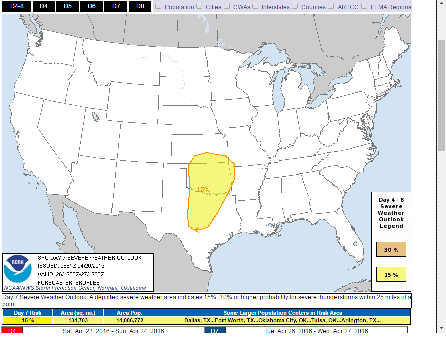
this type of environment will intensify rapidly. Already SPC is highlighting the southern plains for a severe weather outbreak on day seven- which is
highly unusual. Here is a map showing the potential energy next Wednesday.
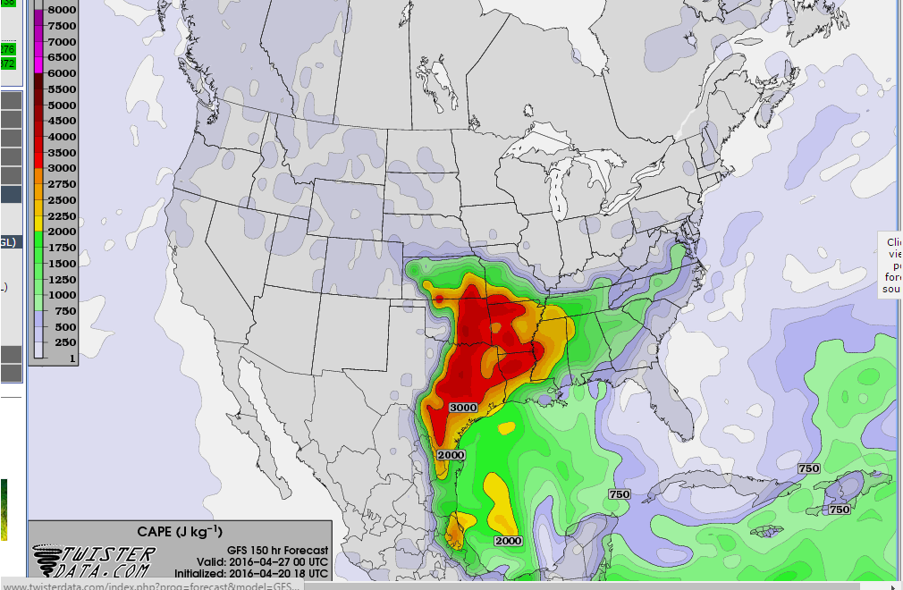
this is a low resolution picture of the CAPE values anywhere on the order of 3000j/kg and above.
Here is what the SPC has to say about next week and its highlight
At this point in time giving the precise details of the outbreak is impossible, but these cape values along with a dryline organizing to the west and several shortwave troughs forecast to provide lift over the area, this needs to be monitored for the potential of a WIDE SPREAD DAMAGING OUTBREAK and multi day event. I just wanted to give you all a quick heads up, and im going to go out on a limb here and say if there is a week to chase and see a spectacular show, and potentially very damaging and deadly, it is next week.
here we go again.
If you wish to watch the stormchasers next week here is a LINK
Also, tonight we are expecting a Quasi-Linear Convective System to roll through, it does have an attendant threat of some severe weather (slight chance) namely large hail and perhaps 50mph to 60mph winds, it likely will be weakening as it moves through the north central Texas area but it is something to keep an eye on, we are expecting it around 3am to 6am this morning.

this is a low resolution picture of the CAPE values anywhere on the order of 3000j/kg and above.
Here is what the SPC has to say about next week and its highlight

THE MODELS SUGGEST A DRYLINE ORGANIZES ACROSS THE SRN PLAINS DURING THE DAY ON TUESDAY WITH THUNDERSTORMS DEVELOPING ALONG AND EAST OF THE DRYLINE LATE TUESDAY AFTERNOON. THE ECMWF SOLUTION ALSO SHOWS THE EXIT REGION OF A MID-LEVEL JET OVERSPREADING THE SRN PLAINS ON TUESDAY. THE MODELS ARE IN GENERAL AGREEMENT AND HAVE SHOWN ENOUGH RUN TO RUN CONSISTENCY TO ADD A 15 PERCENT CONTOUR FOR PARTS OF CNTRL AND NORTH TX...OK...SRN KS...NW AR AND FAR SW MO FOR TUESDAY AND TUESDAY NIGHT. A SEVERE WEATHER EVENT WITH TORNADOES...LARGE HAIL AND WIND DAMAGE WILL BE POSSIBLE. ON WEDNESDAY/DAY 8...THE MODEL SOLUTIONS SHOW SOME VARIANCE WITH THE ECMWF EJECTING THE UPPER-LEVEL TROUGH ENEWD ACROSS THE MS VALLEY WHILE THE GFS IS SLOWER KEEPING THE INSTABILITY AXIS BACK OVER THE SRN PLAINS. ALTHOUGH A SEVERE THREAT APPEARS PROBABLE TO DEVELOP ACROSS PARTS OF THE SCNTRL U.S. ON WEDNESDAY...WILL GO PREDICTABILITY TOO LOW DUE TO MODEL DIFFERENCES.
At this point in time giving the precise details of the outbreak is impossible, but these cape values along with a dryline organizing to the west and several shortwave troughs forecast to provide lift over the area, this needs to be monitored for the potential of a WIDE SPREAD DAMAGING OUTBREAK and multi day event. I just wanted to give you all a quick heads up, and im going to go out on a limb here and say if there is a week to chase and see a spectacular show, and potentially very damaging and deadly, it is next week.
here we go again.
If you wish to watch the stormchasers next week here is a LINK
Also, tonight we are expecting a Quasi-Linear Convective System to roll through, it does have an attendant threat of some severe weather (slight chance) namely large hail and perhaps 50mph to 60mph winds, it likely will be weakening as it moves through the north central Texas area but it is something to keep an eye on, we are expecting it around 3am to 6am this morning.
edit on 20-4-2016 by TechniXcality because: (no reason given)
Interesting, but I imagine that just like with winter weather, this area has a chance of shifting north or south yet as time progresses. Definitely
something to keep an eye on though.
I know even though we didn't catch much rain from this last one, the pressure changes kicked my butt migraine wise. I wound up with two nasty ones over the course of the event and it's not quite done going by yet.
I know even though we didn't catch much rain from this last one, the pressure changes kicked my butt migraine wise. I wound up with two nasty ones over the course of the event and it's not quite done going by yet.
yep, yep.....I'm a trained meteorologist......two years of aviation weather, anyway.......does that count?
every year it does this . the tornados go up north to Oklahoma.....here in Dallas.....it's always the same days.....May 3rd or 4th....clobbered good like.....I mean it, too
I've tracked it since the Branniff air disaster on May 3 68 or 69.......enough to knock an Electra out of the sky near Corsicanna
edit on
20-4-2016 by GBP/JPY because: our new King.....He comes right after a nicely done fake one
edit on 20-4-2016 by GBP/JPY because: last
minute thought there....yezz
a reply to: TechniXcality
And with the cold jet stream dipping into the warm wet lowpressure system...
Could get nasty, real nasty...
www.intellicast.com...
And with the cold jet stream dipping into the warm wet lowpressure system...
Could get nasty, real nasty...
www.intellicast.com...
Yeah these last few days have been something. I love monsoon weather in the southern regions, it reminds me that all of the things we've built over
these flat lands doesn't mean squat because nature still rules supreme.
sucks about people losing their homes and for some their lives, but the sheer power and mystery behind storm systems are so captivating. It looks like the storm cell is projected to hit higher near the oaklahoma/tx border. however experience suggests it will drop its load south a few hundred miles exactly where the last one came through.
sucks about people losing their homes and for some their lives, but the sheer power and mystery behind storm systems are so captivating. It looks like the storm cell is projected to hit higher near the oaklahoma/tx border. however experience suggests it will drop its load south a few hundred miles exactly where the last one came through.
a reply to: TechniXcality
I am TVN fan, I live in North Texas too, and a very good friend is a chaser. I personally don't like it when he gets excited about next week in our area! I am working in Mississippi now and not sure if I want to go home yet after this!
I am TVN fan, I live in North Texas too, and a very good friend is a chaser. I personally don't like it when he gets excited about next week in our area! I am working in Mississippi now and not sure if I want to go home yet after this!
Love it, looking forward to storm seasons like we had in the last few years of the 90s. Hot and heavy. I'm all over it.
a reply to: du Pelican Blanc
I'm excited myself, however it's an anticipation excitement with the solemn knowledge a lot of damage and even lost lives could occur, which is why I try to give as much advanced warnings to those following these threads, next week will be the week to chase.
I'm excited myself, however it's an anticipation excitement with the solemn knowledge a lot of damage and even lost lives could occur, which is why I try to give as much advanced warnings to those following these threads, next week will be the week to chase.
a reply to: TechniXcality
One more time, Thank You. This has not been mentioned locally yet.
TX is getting hit hard this year where as the last few years it has been more OK and Kansas.
Will follow and glad to see more weather watchers come on board.
One more time, Thank You. This has not been mentioned locally yet.
TX is getting hit hard this year where as the last few years it has been more OK and Kansas.
Will follow and glad to see more weather watchers come on board.
a reply to: liveandlearn
Yes will do my best to keep you informed this one looks like the one, the big one..
Yes will do my best to keep you informed this one looks like the one, the big one..
originally posted by: TechniXcality
a reply to: Bigburgh
I can't that's where this baby sits.
And I'm jealous 😊 strap and inflatable bed on the truck then. Stay safe, and post if you can.👍
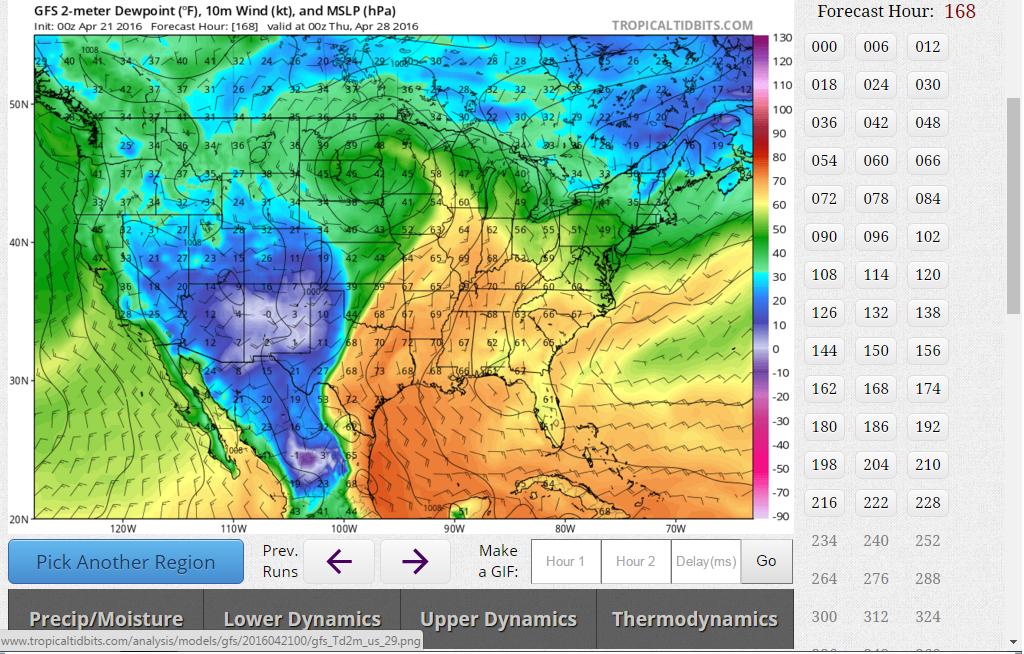
Thanks for this, can you draw the "anticipated dry line" roughly for me?
Dumb question, but I'm having trouble visualizing it?
Dumb question, but I'm having trouble visualizing it?
a reply to: Caver78
Yes not a problem..
Here is the latest 00z GFS output for Wednesday at 6pm the dew points are in the 70s east of the dry, line highlighted in orange and yellow, and the dew points in the teens and single digits to the west, highlighted in green and blue, This model has the dry line much further west than the previous run near Sweetwater, just west of Abilene, the dry line placement is important for thunderstorm initiation, and models will likely waver over the next five days until we have a clear picture of all the mesoscale features and dynamics but this is currently where its forecast to be Wednesday at 6pm.

a reply to: TechniXcality
This is an ugly forced march, that blue snowball E/SE straight
down the Snake (if ever could be it called 'straight').
Not time to dig in or anything, but whoever suggested the
air mattress is your friend. ps woot on the 'cuda holes.
This is an ugly forced march, that blue snowball E/SE straight
down the Snake (if ever could be it called 'straight').
Not time to dig in or anything, but whoever suggested the
air mattress is your friend. ps woot on the 'cuda holes.
SPC UPDATE regarding next week.
DAY 4-8 CONVECTIVE OUTLOOK NWS STORM PREDICTION CENTER NORMAN OK 0339 AM CDT THU APR 21 2016 VALID 241200Z - 291200Z ...DISCUSSION... THE MEDIUM RANGE MODELS BEGIN THE DAY 4 TO 8 PERIOD WITH AN UPPER-LEVEL TROUGH IN THE CNTRL ROCKIES AND MOVE THIS FEATURE EWD INTO THE GREAT PLAINS ON SUNDAY/DAY 4. AHEAD OF THE UPPER-LEVEL TROUGH...AN ISOLATED SEVERE THREAT MAY DEVELOP SUNDAY AFTERNOON ALONG AN AXIS OF INSTABILITY EXTENDING NNEWD FROM THE SRN PLAINS INTO THE MID MO VALLEY. ON MONDAY/DAY 5...THE MODELS BRING A SHORTWAVE RIDGE NEWD ACROSS THE CNTRL PLAINS AND MAINTAIN AN AXIS OF INSTABILITY IN THE SRN PLAINS WHERE AN ISOLATED SEVERE THREAT WILL AGAIN BE POSSIBLE. ON TUESDAY/DAY 6...THE ECMWF AND GFS CONTINUE TO MOVE A NEGATIVELY-TILTED UPPER-LEVEL TROUGH AND ASSOCIATED MID-LEVEL JET ENEWD ACROSS THE SRN ROCKIES AND INTO THE SRN PLAINS. THE MODELS SHOW A WELL-DEVELOPED DRYLINE ACROSS THE SRN AND CNTRL PLAINS TUESDAY AFTERNOON. TO THE EAST OF THE DRYLINE...SFC DEWPOINTS IN THE MID TO UPPER 60S F AND STRONG DESTABILIZATION SHOULD BE FAVORABLE FOR SUPERCELLS. AS THE EXIT REGION OF THE MID-LEVEL JET OVERSPREADS A VERY MOIST AND UNSTABLE AIRMASS...A SEVERE WEATHER OUTBREAK WILL BE POSSIBLE WITH TORNADOES...LARGE HAIL AND WIND DAMAGE TUESDAY AFTERNOON AND EVENING. THE MODELS HAVE BEEN CONSISTENT ENOUGH TO WARRANT ADDING A 30 PERCENT CONTOUR ACROSS PARTS OF NORTH TX...OK AND SRN KS. ON WEDNESDAY/DAY 7...THE MODELS ARE IN REASONABLE AGREEMENT MOVING THE UPPER-LEVEL TROUGH INTO THE MO VALLEY AND HAVING AN AXIS OF INSTABILITY IN THE MID MS VALLEY EXTENDING SWWD INTO THE SRN PLAINS. SEVERE THUNDERSTORMS MAY OCCUR ALONG PARTS OF THIS CORRIDOR WEDNESDAY AFTERNOON AND EVENING WHERE A SIGNIFICANT SEVERE WEATHER EVENT WILL BE POSSIBLE. ON THURSDAY/DAY 8...ANOTHER UPPER-LEVEL TROUGH IS FORECAST TO DEVELOP IN THE SWRN U.S. WITH SOUTHWEST FLOW IN PLACE IN THE SRN PLAINS WHERE SEVERE THUNDERSTORMS WILL AGAIN BE POSSIBLE THURSDAY AFTERNOON AND EVENING.
a reply to: TechniXcality
A lot of folks don't know thus but many of us here in NTX don't have basements due to soil composition.
Honest question - at what point would it be a good idea to maybe take an impromptu vacation with the wife and dogs further west?
I only ask because she is 25 weeks pregnant and when you say the "big one" it makes me pretty nervous. If it was just me to worry about I'd ask if you knew any one I could join on the chase
a reply to: SonOfThor
Hey, brother
First congratulations, fatherhood and having a family is one of the if not the most rewarding experiences you can have, and i am very happy for you
I do not want to get you traveling yet,(as things can change) it appears that a potentialy significant, wide spread severe weather outbreak will occur across the southern plains next week, its almost impossible at this point to give the finer details of where and when, I made this thread to give everyone the heads up that next week looks volatile and also destructive, its particularly concerning. As we get closer model data will have higher resolution and I would be about to give you the best time to make plans, but if you have vacation available and have the adventuresome spirit perhaps next week starting Monday would be a good time to travel. I will continue to update as more data is available and i will specifically give you more information, thanks for always stopping by and I am happy to answer any question you have to the best of my ability. Cheers
edit on
21-4-2016 by TechniXcality because: (no reason given)
new topics
-
Imagine how it feels
US Political Madness: 11 minutes ago -
Do I post here or Cryptozoology.
Ancient & Lost Civilizations: 48 minutes ago -
Breakthrough treatment flips cancer cells back into normal cells
General Chit Chat: 1 hours ago -
New World Order Coming?
New World Order: 1 hours ago -
Short vs. Long?
General Chit Chat: 10 hours ago
top topics
-
Outgoing Lame Duck BIDEN Officials and Democrats Voice Their Regrets.
2024 Elections: 14 hours ago, 10 flags -
Reflections of Elections past
US Political Madness: 16 hours ago, 6 flags -
Short vs. Long?
General Chit Chat: 10 hours ago, 4 flags -
Breakthrough treatment flips cancer cells back into normal cells
General Chit Chat: 1 hours ago, 3 flags -
Do I post here or Cryptozoology.
Ancient & Lost Civilizations: 48 minutes ago, 2 flags -
New World Order Coming?
New World Order: 1 hours ago, 1 flags -
Imagine how it feels
US Political Madness: 11 minutes ago, 1 flags
active topics
-
Imagine how it feels
US Political Madness • 3 • : GENERAL EYES -
Joe Rogan and The Black Keys Diorama
General Entertainment • 7 • : ColeYounger2 -
Reflections of Elections past
US Political Madness • 4 • : xuenchen -
Why Such An Uproar Over Non-US Citizens With H1-B Work Visas.
Social Issues and Civil Unrest • 94 • : xuenchen -
-@TH3WH17ERABB17- -Q- ---TIME TO SHOW THE WORLD--- -Part- --44--
Dissecting Disinformation • 3849 • : DontTreadOnMe -
Do I post here or Cryptozoology.
Ancient & Lost Civilizations • 3 • : AdultMaleHumanUK -
New World Order Coming?
New World Order • 13 • : SteamyAmerican -
Get Reday - Here comes the Bird Flu Pandemic - Millions are Notified
Diseases and Pandemics • 33 • : SteamyAmerican -
Christmas Car Near Detroit…
Automotive Discussion • 16 • : JJproductions -
Breakthrough treatment flips cancer cells back into normal cells
General Chit Chat • 2 • : SteamyAmerican

