It looks like you're using an Ad Blocker.
Please white-list or disable AboveTopSecret.com in your ad-blocking tool.
Thank you.
Some features of ATS will be disabled while you continue to use an ad-blocker.
share:
a reply to: Qudrelth
Yes & rare indeed, especially off the east coast. The last one in this Area was out from St. Augustine in 1879.
earthquake.usgs.gov...
I tried finding any info on the geology of the Blake Plateau offshore of Florida & why this might have caused this
& nada...
Yes & rare indeed, especially off the east coast. The last one in this Area was out from St. Augustine in 1879.
earthquake.usgs.gov...
I tried finding any info on the geology of the Blake Plateau offshore of Florida & why this might have caused this
& nada...
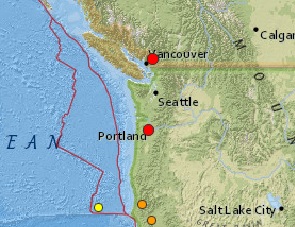
3.2
2km SE of Aloha, Oregon
2016-07-17 01:16:43 (UTC)
earthquake.usgs.gov...
(downgraded to 3.0)
3.2
28km NE of Coquitlam, Canada
2016-07-17 00:42:53 (UTC)
earthquake.usgs.gov...
Seeing both on the EQ map kind of weirded me out for a second....

2km SE of Aloha, Oregon
2016-07-17 01:16:43 (UTC)
earthquake.usgs.gov...
(downgraded to 3.0)
3.2
28km NE of Coquitlam, Canada
2016-07-17 00:42:53 (UTC)
earthquake.usgs.gov...
Seeing both on the EQ map kind of weirded me out for a second....

edit on 16-7-2016 by Darkblade71 because: downgrade
5.0-5.2, 36.052, 139.9351, Eastern Honshu. Japan
www.jma.go.jp...
Preliminary data from NIED shows it located 4.7km NE of the 5.5 of 16/05/2016 21:23 at Otone Country Club Golf Course in Bando
14 aftershocks at this point in time.
The 5.5 didn't have too many aftershocks, 35 in the 4 days following, the largest a 4.1, 9:34:32 hours after the main shock.
Weird how some of these land based quakes in Japan don't have many aftershocks, whereas others have thousands of them.
When they have few I always wonder if there isn't something bigger brewing in the near future.
edit on 0700000019819816 by muzzy because: (no
reason given)
Couple of mid 4 quakes down south of NZ yesterday
Intensity strong
NZST Sun, Jul 17 2016, 2:42:40 am
Depth 14 km
Magnitude 4.6
Location 135 km north-west of Snares Islands
www.geonet.org.nz...
Intensity strong
NZST Sat, Jul 16 2016, 6:29:29 pm
Depth 12 km
Magnitude 4.4
Location 100 km west of Snares Islands
www.geonet.org.nz...
or
16.07.2106 NZ
Intensity strong
NZST Sun, Jul 17 2016, 2:42:40 am
Depth 14 km
Magnitude 4.6
Location 135 km north-west of Snares Islands
www.geonet.org.nz...
Intensity strong
NZST Sat, Jul 16 2016, 6:29:29 pm
Depth 12 km
Magnitude 4.4
Location 100 km west of Snares Islands
www.geonet.org.nz...
or
16.07.2106 NZ
Gotta a'little swarm going on here.
3.8 SSE of Ridgemark, Cali
earthquake.usgs.gov...
With this one being the largest.
3.8 SSE of Ridgemark, Cali
earthquake.usgs.gov...
With this one being the largest.
UH OH?
I hope this was not a working mine!!!
M 3.4 Mine Collapse - 11km NNW of Richlands, Virginia
Time
2016-07-18 09:53:39 (UTC)
Location
37.189°N 81.832°W
Depth
0.0 km
I hope this was not a working mine!!!
edit on 7/18/16 by BlueAjah because: (no reason given)
a reply to: BlueAjah
I saw that too. Looked for information on it. And at this time they are not confirming anything.
Must have been a very large collapse to create a 3.4.
When I saw that I first thought of Bayou Corn.
I saw that too. Looked for information on it. And at this time they are not confirming anything.
Must have been a very large collapse to create a 3.4.
When I saw that I first thought of Bayou Corn.
edit on 18-7-2016 by crappiekat because: to add
The Florida quake is now called a
"M 3.7 Experimental Explosion - 168km ENE of Daytona Beach Shores, Florida"
What does THAT mean? what kind of Experimental Explosion??
USGS Quake Site
"M 3.7 Experimental Explosion - 168km ENE of Daytona Beach Shores, Florida"
What does THAT mean? what kind of Experimental Explosion??
USGS Quake Site
edit on
7/18/2016 by Pharyax because: (no reason given)
a reply to: Pharyax
Wow , when I posted it the other day I kinda thought this earthquake was a little weird???
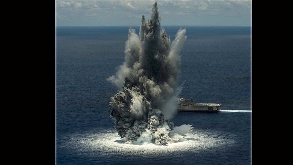
“Officials said it was really triggered by a man-made explosion designed to test the new U.S. Navy combat ship, USS Jackson.
"The shock trials are designed to demonstrate the ship's ability to withstand the effects of nearby underwater explosion and retain required capability." according to a Navy statement.
Officials said a 10,000-pound explosive charge was detonated a few hundred yards from the vessel off Florida’s Atlantic coast.”
cbs12.com...
www.livescience.com...
a reply to: Pharyax
Wow , when I posted it the other day I kinda thought this earthquake was a little weird???

“Officials said it was really triggered by a man-made explosion designed to test the new U.S. Navy combat ship, USS Jackson.
"The shock trials are designed to demonstrate the ship's ability to withstand the effects of nearby underwater explosion and retain required capability." according to a Navy statement.
Officials said a 10,000-pound explosive charge was detonated a few hundred yards from the vessel off Florida’s Atlantic coast.”
cbs12.com...
www.livescience.com...
Wow , when I posted it the other day I kinda thought this earthquake was a little weird???

“Officials said it was really triggered by a man-made explosion designed to test the new U.S. Navy combat ship, USS Jackson.
"The shock trials are designed to demonstrate the ship's ability to withstand the effects of nearby underwater explosion and retain required capability." according to a Navy statement.
Officials said a 10,000-pound explosive charge was detonated a few hundred yards from the vessel off Florida’s Atlantic coast.”
cbs12.com...
www.livescience.com...
edit on 18-7-2016 by SeekingDepth because: added pic
a reply to: SeekingDepth
Very cool, saw that link! So they test up to 40,000lb charges to test hull strength? WOW... and the sloping of the sea floor amplifies the sound.
FIRST thing I thought when I saw the quake, I was thinking, ok... MAYBE its linked to the N Carolina fault? But sure seemed far away. then I thought, maybe spaceX lost the lander, but then saw the lander landed fine... and times were off.
I DO know they have done this before, but never with a quake registering. heck, a 3.4 is just under what a nuke charge does to a low yield test. Was like, if they break the 1994 test-ban, crap is about to go bad.
They DID say the SpaceX lander causes a sonic boom in Florida.. When I was there, and the shuttle would come in, you'd sometimes get booms that would make you jump, if you didn't know it was coming in. but when you hear the double or triple booomm! boom booom.... echo, then I think, Shuttle!! Switch on the news, and yep. landed fine.
Glad to see spaceX land successfully again! just mind boggling how they send it up, deploy the payload and send back the lower part and LAND it! really amazing math skillz going on. I personally don't like math, I use PC's to do my number crunching so I can move on to other things. hehe..
edit on 7/19/2016 by Pharyax because: (no reason given)
Just for fun, can anyone post the seismograph signature from this Navy test? Just wanna see what It looks like. I know the difference between nuke
tests and normal quakes. I SHOULD have just looked up the seismograph on it. would be interesting to see if it looks close to a nuke test.
a reply to: Pharyax
Olivine posted one and TA posted one in the thread I made about this, here is his post:
Olivine posted one and TA posted one in the thread I made about this, here is his post:
originally posted by: TrueAmerican
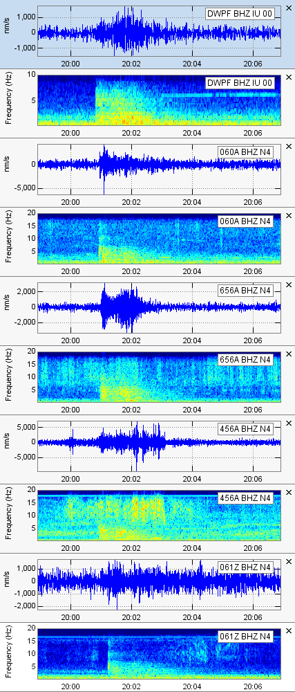
Wow- ok. Now that we know it was an explosion, I went and pulled raw seismic data from 5 stations, and was able to generate both waveforms and spectro of the boom:
For each station, the waveform is on top with its associated spectrograph below it.
Now what gets me about this is that the USGS did not immediately report this as an explosion. You see, they are supposed to be able to tell from close analysis of the waveform data. It's kind of scary to think, actually, that a massive explosion could go off and the USGS would report it as an earthquake initially. If you look closely at the waveforms, there are differences between these and a typical earthquake. The USGS is supposed to spot these differences and recognize them. Our national security could depend on it.
USGS FAIL.
The waveform from station 656A is the clear giveaway that should have been recognized as an explosion. I know this signature from studying nuclear blast signatures. The waveform data from that last North Korea nuke test explosion looks strikingly similar, for example.
edit on
19-7-2016 by jadedANDcynical because: see Olivine's post, lol
originally posted by: crappiekat
Gotta a'little swarm going on here.
3.8 SSE of Ridgemark, Cali
earthquake.usgs.gov...
With this one being the largest.
Ridgemark, Cali seems to be kicking it up a notch.
4.2 Ridgemark, Cali
earthquake.usgs.gov...
Just came here because that's what I do when
I feel a weird pressure change and my ears started
ringing more than ever.
Did a coronal mass ejection just start as well ?
I feel a weird pressure change and my ears started
ringing more than ever.
Did a coronal mass ejection just start as well ?
edit on 19-7-2016 by UnderKingsPeak because: question
a reply to: UnderKingsPeak
Yes. if you follow SO.
CME hit a few hours ago.
Watching earthquake action.
Yes. if you follow SO.
CME hit a few hours ago.
Watching earthquake action.
edit on 19-7-2016 by crappiekat because: to add
new topics
-
Prisoner CNN helped free from Syrian prison was actually notorious Assad regime torturer: report
Mainstream News: 38 minutes ago -
Labour Plotting to Postpone May's Council Elections ?
Regional Politics: 2 hours ago -
Is this really what is going on?
General Conspiracies: 2 hours ago -
Russias War Against Religion in Ukraine
World War Three: 3 hours ago -
iPhone Microphone Being Accessed by Unknown App
The Gray Area: 5 hours ago -
Democrats send letter to Biden urging him to ratify Equal Rights Amendment
US Political Madness: 11 hours ago
top topics
-
iPhone Microphone Being Accessed by Unknown App
The Gray Area: 5 hours ago, 10 flags -
Is this really what is going on?
General Conspiracies: 2 hours ago, 7 flags -
Democrats send letter to Biden urging him to ratify Equal Rights Amendment
US Political Madness: 11 hours ago, 4 flags -
Russias War Against Religion in Ukraine
World War Three: 3 hours ago, 4 flags -
Prisoner CNN helped free from Syrian prison was actually notorious Assad regime torturer: report
Mainstream News: 38 minutes ago, 4 flags -
Labour Plotting to Postpone May's Council Elections ?
Regional Politics: 2 hours ago, 2 flags
active topics
-
The Acronym Game .. Pt.4
General Chit Chat • 1018 • : tinkerbell99 -
Is this really what is going on?
General Conspiracies • 16 • : LSU2018 -
Drones everywhere in New Jersey ---and Elsewhere Master Thread
Aliens and UFOs • 182 • : underpass61 -
Only two Navy destroyers currently operational as fleet size hits record low
Military Projects • 32 • : Oldcarpy2 -
The Mystery Drones and Government Lies --- Master Thread
Political Conspiracies • 117 • : Guyfriday -
Prisoner CNN helped free from Syrian prison was actually notorious Assad regime torturer: report
Mainstream News • 0 • : xuenchen -
Russias War Against Religion in Ukraine
World War Three • 7 • : FlyersFan -
More Bad News for Labour and Rachel Reeves Stole Christmas from Working Families
Regional Politics • 10 • : Bilbous72 -
Labour Plotting to Postpone May's Council Elections ?
Regional Politics • 1 • : gortex -
Democrats send letter to Biden urging him to ratify Equal Rights Amendment
US Political Madness • 9 • : Texastruth2

