It looks like you're using an Ad Blocker.
Please white-list or disable AboveTopSecret.com in your ad-blocking tool.
Thank you.
Some features of ATS will be disabled while you continue to use an ad-blocker.
share:
a reply to: antar
In terms of tornado's no, but that area is expecting over 10 inches of rain and parts of the highway could be shut down tomorrow.
28th-5th looks to be dry and chilly, but that is subject to change as well with such a powerful storm the models math goes crazy and usually does not have a good handle on the dynamics of this storm or the future pattern.
If they are traveling tomorrow flooding is a serious concern. Stay safe
edit on 26-12-2015 by TechniXcality because: (no reason given)
This storm moving into south Dallas which is tornado warned is taking on a characteristics of very powerful super cell its classic hook echo or C
shape in the southwest quadrant is evident. Perhaps ill get to see this one in person, stay safe you all.
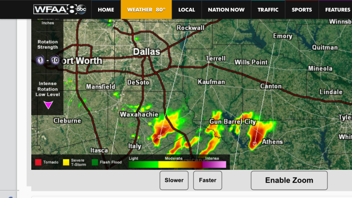

I'm in Colorado and have been watching this one pretty closely. It's shifted way south but they are getting about 2 more feet of snow in the
mountains/ski areas. Could've been our second major snow fall but it has stayed south, thank God.
It's been very cold here and had all that moisture hit, I doubt I would've made it into to work tonight. It's SUPER windy here though, making it feel well below zero, so we are feeling a bit of winter storm Goliath.
Stay safe!
It's been very cold here and had all that moisture hit, I doubt I would've made it into to work tonight. It's SUPER windy here though, making it feel well below zero, so we are feeling a bit of winter storm Goliath.
Stay safe!
edit on 26-12-2015 by lovebeck because: (no reason given)
a reply to: TechniXcality
The flooding is very very scary. I don't think that yet today people realize the hazards of quickly rising and fast moving water. The warnings are plenty but, people seem oblivious to heed those warnings.
When I was young, in PA there was a bad bad flood.
I vaguely remember tales of Dad and his church group going to stay and help people...it was the stuff of legends in the small town I was from...
Just yesterday the old man's brother called to say his ex wife may have been carried off by flood waters in Southern TN.
We still have not confirmed if this is true.
There's a river/creek that comes off of the mountain. There's a 5 foot or so high tunnel that the water passes through that goes for about 2 or 3 miles. It ends up at the TN river eventually and she may have been swept into it...
The aftermath and destruction can total and complete and with snow coming right behind it, deadly.
Offering up positive thoughts to our neighbors in the midwest/middle southern parts!
The flooding is very very scary. I don't think that yet today people realize the hazards of quickly rising and fast moving water. The warnings are plenty but, people seem oblivious to heed those warnings.
When I was young, in PA there was a bad bad flood.
The new river walls withstood Hurricane Agnes in 1972, but on the night of July 19, 1977, a severe thunderstorm dropped 11 inches of rain in eight hours on the watershed above the city and the rivers began to rise. By dawn, the city was under water that reached as high as 8 feet (2.4 m). Seven counties were declared a disaster area, suffering $200 million in property damage, and 78 people died. Forty were killed by the Laurel Run Dam failure. Another 50,000 were rendered homeless as a result of this "100-year flood". Markers on a corner of City Hall at 401 Main Street show the height of the crests of the 1889, 1936, and 1977 floods.
I vaguely remember tales of Dad and his church group going to stay and help people...it was the stuff of legends in the small town I was from...
Just yesterday the old man's brother called to say his ex wife may have been carried off by flood waters in Southern TN.
We still have not confirmed if this is true.
There's a river/creek that comes off of the mountain. There's a 5 foot or so high tunnel that the water passes through that goes for about 2 or 3 miles. It ends up at the TN river eventually and she may have been swept into it...
The aftermath and destruction can total and complete and with snow coming right behind it, deadly.
Offering up positive thoughts to our neighbors in the midwest/middle southern parts!
This thing is expected to lift up over our area Sunday through Monday. They are still pinning down the final track, but depending, we could get
anywhere from just rain to ice to a good amount of snow.
I felt bad for the grocery stores. We just got back from doing our own shopping a day early. They were already cleaned out from Christmas, and instead of getting the day to restock, they were getting slammed with a full-fledged French toast alert. A lot of stuff was cleaned out and it was only going to get worse.
I felt bad for the grocery stores. We just got back from doing our own shopping a day early. They were already cleaned out from Christmas, and instead of getting the day to restock, they were getting slammed with a full-fledged French toast alert. A lot of stuff was cleaned out and it was only going to get worse.
a reply to: TNMockingbird
I hope she is safe , and thank you for bringing this up, as you are 100% correct severe weather does not exclude flooding in fact flooding can be the most damaging and dangerous of all modes of severe weather.
I hope she is safe , and thank you for bringing this up, as you are 100% correct severe weather does not exclude flooding in fact flooding can be the most damaging and dangerous of all modes of severe weather.
For what it's worth, at the moment across KC and the I-70 corridor as you head out past Topeka, the weather is cold and the atmosphere is heavy. There
is plenty of moisture in place.
We've had occasional periods of drizzle off and on all day.
It isn't quite cold enough to freeze yet, but it is cold enough to make life, the universe and everything unpleasant.
So basically we're in a holding pattern with plenty of ammo for when this storm decides to move in depending on IF it decides to move.
Oh crap
Not looking forward to this one. Should be hitting my area sometime tonight or tomorrow.
Thanks for this thread. I appreciate the info.
Not looking forward to this one. Should be hitting my area sometime tonight or tomorrow.
Thanks for this thread. I appreciate the info.
NWS just issued a discussion on this storm in north Texas, highlighting the tornados flooding and winter weather risks to come, they used very serious
wording, anyone in the path of this storm should pay attention to their local forecast this storm is similar to a hurricane in strength.
From NWS
From NWS
000 FXUS64 KFWD 262008 AFDFWD AREA FORECAST DISCUSSION NATIONAL WEATHER SERVICE FORT WORTH TX 208 PM CST SAT DEC 26 2015 .DISCUSSION... WITH A TORNADO WATCH IN EFFECT FOR ALL OF NORTH AND CENTRAL TEXAS...WILL KEEP THE FORECAST DISCUSSION FOCUSED ON THE MAIN THREATS ASSOCIATED WITH THE UPPER LEVEL STORM SYSTEM APPROACHING FROM THE WEST. SEVERE WEATHER THREAT: THE MAIN WINDOW OF OPPORTUNITY FOR SEVERE STORMS IS THIS AFTERNOON THROUGH OVERNIGHT TONIGHT...PRIMARILY ALONG AND SOUTHEAST OF A COLD FRONT MOVING SLOWLY SOUTHEAST ACROSS THE REGION. FOR THIS AFTERNOON AND EVENING: THE 18Z FWD RAOB INDICATED OVER 2000 J/KG OF SURFACE BASED CAPE IN PLACE OVER THE REGION...WITH NO SIGNIFICANT CAP IN PLACE INHIBITING CONVECTION. DEEP LAYER AND LOW-LEVEL SHEAR PROFILES ARE SUPPORTIVE OF SUPERCELL THUNDERSTORMS CAPABLE OF PRODUCING TORNADOES. THE 18 UTC FWD RAOB NUMBERS RANK HIGHLY IN THE PARAMETER SPACE SUPPORTIVE OF SIGNIFICANT TORNADOES ACCORDING TO THE STORM PREDICTION CENTERS SEVERE WEATHER ENVIRONMENT CLIMATOLOGY. AS A RESULT...THINK THAT SUPERCELL THUNDERSTORMS CAPABLE OF PRODUCING TORNADOES WILL POSE A SIGNIFICANT THREAT TO THE REGION THROUGH THIS EVENING. THE ONLY MISSING INGREDIENT THAT WOULD SUPPORT A MORE WIDESPREAD SEVERE WEATHER OR TORNADO OUTBREAK IS STRONG LIFT OVER THE REGION. LIFT IS GENERALLY WEAK AND LACKS FOCUS...HOWEVER THE ENVIRONMENT IS UNCAPPED. EVEN WEAK LIFT MAY BE ENOUGH FOR SCATTERED SEVERE STORM/SUPERCELL DEVELOPMENT ACROSS THE REGION THROUGH THIS EVENING. A TORNADO WATCH REMAINS IN EFFECT THROUGH 8 PM FOR ALL OF NORTH AND CENTRAL TEXAS AS A RESULT. ASSUMING SUPERCELL THUNDERSTORMS CONTINUE TO DEVELOP IN THIS ENVIRONMENT...SIGNIFICANT TO VIOLENT TORNADOES ARE POSSIBLE. THE TORNADO THREAT MAY DIMINISH LATE THIS EVENING AFTER SEVERAL HOURS OF COOLING...THOUGH THE SEVERE WEATHER THREAT WILL LIKELY PERSIST ALONG AND SOUTHEAST OF THE COLD FRONT. OVERNIGHT INTO SUNDAY: THE THREAT FOR SUPERCELLS WILL CONTINUE OVERNIGHT ALONG AND SOUTHEAST OF THE COLD FRONT. THE TORNADO THREAT MAY DIMINISH A BIT...BUT WILL NOT LIKELY BECOME ZERO AT ANY POINT SOUTHEAST OF THE FRONT WITH NEAR 70 DEW POINTS IN PLACE. THE SPEED OF THE FRONT WILL LARGELY DETERMINE THE SEVERE WEATHER THREAT FOR SUNDAY. IF THE FRONT STALLS OUT ACROSS THE CWA...THE THREAT FOR SUPERCELLS AND TORNADOES WILL LIKELY BE PRESENT AGAIN...ALONG AND SOUTHEAST OF WHEREVER THE FRONT STALLS. IF THE FRONT STALLS IN THE CWA...IT IS MOST LIKELY TO STALL OUT NEAR A PARIS TO DALLAS TO TEMPLE LINE. FLASH FLOODING THREAT: THE FLASH FLOODING THREAT IS EXPECTED TO BE THE GREATEST ALONG AND BEHIND THE COLD FRONT...ESPECIALLY IF IT STALLS OUT SUNDAY AFTERNOON. FLASH FLOODING IS LIKELY THE MOST WIDESPREAD THREAT FOR THE REGION. WITH SOIL MOISTURE CONDITIONS AND THE TRINITY RIVER BASIN ALREADY STARTING OUT ABOVE NORMAL...THERE IS NOT MUCH STORAGE CAPACITY FOR SIGNIFICANT RAINFALL AND RUNOFF. WITH 3-6 INCHES (AND ISOLATED HIGHER AMOUNTS) EXPECTED ALONG AND EAST OF INTERSTATE 35...SIGNIFICANT FLASH FLOODING IS POSSIBLE. ADDITIONAL RIVER FLOODING ALL ALONG THE TRINITY IS LIKELY AS WELL. THE PRIMARY FLASH FLOODING THREAT IS LIKELY TONIGHT THROUGH SUNDAY...AGAIN...ALONG AND BEHIND THE FRONTAL BOUNDARY. WINTRY PRECIPITATION: THE FORECAST REMAINS LARGELY UNCHANGED FROM THE OVERNIGHT FORECAST. RAIN IS LIKELY TO CHANGE OVER TO SNOW ON THE BACK SIDE OF THE UPPER LOW SUNDAY NIGHT THROUGH MONDAY MORNING. THIS UPPER LEVEL LOW IS AN INCREDIBLY DYNAMIC SYSTEM SPORTING OVER 120 KTS OF WIND AT THE 500 MB LEVEL AND WITH TEMPERATURES DOWN TO -36 DEG C AT THE 500 MB LEVEL. THE COLD AIR ALREADY WRAPPED UP IN THIS SYSTEM COMPARED TO THE INCREDIBLY ANOMALOUS SPRING TIME WARMTH AND MOISTURE CURRENTLY IN PLACE OVER THE REGION SUPPORTS A SYSTEM WITH HIGH END POTENTIAL TO DEEPEN AS IT MOVES OUT OVER THE SOUTHERN PLAINS. THE STRONG POTENTIAL FOR CYCLOGENESIS ASSOCIATED WITH THE INTENSE BAROCLINICITY PROGGED BY MODELS FOR SUNDAY AFTERNOON THROUGH MONDAY MEANS THAT THIS IS THE PORTION OF THE FORECAST MOST SUSCEPTIBLE TO CHANGE OVER THE NEXT 36 HOURS. AS IT STANDS NOW...LOCATIONS WITHIN THE WINTER STORM WATCH...ROUGHLY ALONG AND NORTHWEST OF A LINE FROM BOWIE TO MINERAL WELLS TO CISCO...ARE THE MOST LIKELY TO SEE ACCUMULATING SNOWFALL SUNDAY NIGHT THROUGH MONDAY MORNING. 1-3 INCHES OF SNOWFALL LOOKS LIKELY AT THIS TIME FOR THESE AREAS. EVEN THOUGH THIS IS TECHNICALLY BELOW WINTER STORM WARNING/WATCH CRITERIA... THERE IS THE POTENTIAL FOR ADDITIONAL SNOWFALL DEPENDING ON THE EXACT TRACK OF THE UPPER LOW...AND HOW MUCH IT DEEPENS ONCE OVER THE SOUTHERN PLAINS. EVEN IF 1-3 INCHES OF SNOWFALL IS ALL THAT FALLS...WINDS ARE EXPECTED TO BE SUSTAINED AT 25 KTS GUSTING TO 35 KTS...MEANING THERE WILL BE A GOOD POTENTIAL FOR BLOWING AND DRIFTING OF SNOW WHICH COULD SIGNIFICANTLY INHIBIT TRAVEL ACROSS THE WINTER STORM WATCH AREA. WILL NOT CHANGE THE AREAL OR TEMPORAL COVERAGE OF THE WATCH FOR NOW...BUT WILL BE WATCHING FOR THE POTENTIAL FOR ADDITIONAL WINTER WEATHER IMPACTS AND CHANGES IN THE WATCH COVERAGE AREA IN LATER FORECASTS. AFTER MONDAY...MADE NO SIGNIFICANT CHANGES TO THE PREVIOUS FORECAST. CAVANAUGH && .AVIATION... /ISSUED 556 AM CST SAT DEC 26 2015/ MOIST SOUTHERLY FLOW WILL PREVAIL THROUGH TODAY WITH MVFR CIGS LIKELY. SOME IFR IS POSSIBLE...AND MOS SEEMS ESPECIALLY ADAMANT ON AN IFR OR LIFR CIG FORECAST THROUGH TODAY. HOWEVER CURRENT TEMPERATURES ARE NEARLY EQUAL TO UPSTREAM DEWPOINTS AND THIS RULE OF THUMB SUGGESTS IFR THREAT MAY BE OVER. OTHERWISE WILL SHOW VCSH THROUGH THE DAY FOR SHOWERS THAT WILL STREAM ACROSS THE AREA. MOST RAIN ACTIVITY WILL BE LIGHT AND BRIEF. WILL HAVE TO KEEP AN EYE OUT FOR MORE INTENSE CONVECTION/THUNDERSTORMS THIS AFTERNOON/EVENING...BUT RIGHT NOW THE CHANCE FOR THIS IS TOO LOW TO DELINEATE ANY ONE HOUR SO WILL HAVE TO LEAVE IT OUT OF THE TAF. SOUTH WINDS WILL INCREASE TODAY TO NEAR 20KT AND GUSTY. PREFER THE HI-RES MODELS WHICH SHOW A SLIGHTLY EARLIER COLD FRONTAL PASSAGE...PUTTING IT THROUGH KAFW AROUND 3Z...DFW AROUND 5Z...AND WACO AROUND 7Z. WINDS WILL BECOME NORTHERLY BEHIND THE FRONT AND RAIN/STORM CHANCES WILL ALSO INCREASE NEAR AND JUST BEHIND THE FRONT SO WILL SHOW SHRA AND VCTS AFTER FROPA. STRONGEST PERIOD OF UPPER LEVEL FORCING OCCURS AFTER 7 OR 8Z /1AM OR 2AM TONIGHT/ AND WILL INDICATE PREVAILING TSRA THROUGH EARLY MORNING SUNDAY. TR.92 && .PRELIMINARY POINT TEMPS/POPS... DALLAS-FT. WORTH, TX 54 58 33 42 31 / 100 100 80 20 5 WACO, TX 62 62 32 45 30 / 80 90 50 10 5 PARIS, TX 61 66 36 43 30 / 100 100 90 30 5 DENTON, TX 49 50 32 40 27 / 100 100 80 20 5 MCKINNEY, TX 55 57 33 41 29 / 100 100 80 20 5 DALLAS, TX 56 60 33 43 32 / 100 100 80 20 5 TERRELL, TX 61 64 34 43 30 / 90 100 80 20 5 CORSICANA, TX 65 66 33 45 33 / 80 100 70 10 5 TEMPLE, TX 61 61 31 47 31 / 80 90 50 10 5 MINERAL WELLS, TX 44 44 29 39 26 / 90 100 80 20 5 && .FWD WATCHES/WARNINGS/ADVISORIES... FLASH FLOOD WATCH THROUGH LATE SUNDAY NIGHT FOR TXZ091>095- 102>107-117>123-131>135-144>148-158>162-174-175. WINTER STORM WATCH FROM SUNDAY EVENING THROUGH MONDAY MORNING FOR TXZ091-100-101-115-116-129. && $$
I have to go to Houston this afternoon. I hope it doesn't get too bad this far south. You can definitely feel something coming. We're getting 30 to
40 mph gusts from the coast.
a reply to: TechniXcality
WEll shoot. Maybe I can get their Mom to bring them tonight. Or looks like we may have to put off Christmas eve until the 28th. My boys are going nuts already to open gifts, this being the first and last time we put off Christmas for late comers...
Pretty strong lightning hits here in Polk county today, not constant but strong and earth shaking, odd for Christmas time.
a reply to: TechniXcality
Oh my gosh, you too! Take all your own advice and stay safe. We appreciate you more than you know, we need you to be here for us!!!
Oh my gosh, you too! Take all your own advice and stay safe. We appreciate you more than you know, we need you to be here for us!!!
a reply to: TechniXcality
OK so the 28th it is. Not worth the risk and I dont want their Mom being stuck here... lol
OK so the 28th it is. Not worth the risk and I dont want their Mom being stuck here... lol
a reply to: antar
Yes ma'am thank you for your kind words all you stay safe now, cheers
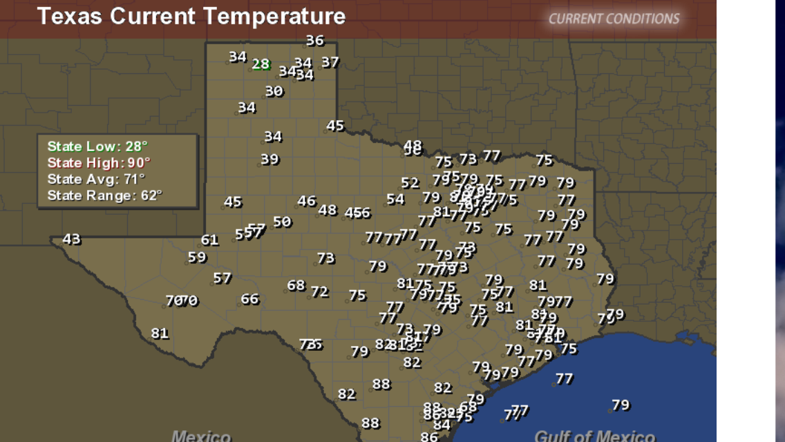
Also notice that the temperature in the panhandle of Texas is 28F (-2c) and in Dallas it is near 80F(26.6c) True artic air is interacting with a Low pressure system that is deepening more and more, a truly dynamic storm system.
Also notice the sustained winds speeds in the pan handle sustained winds of 43mph and gusts over 50mph
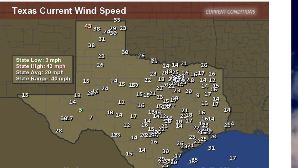
Yup, for all intents and purposes this low pressure is a BEAST, gets me excited about the snow potential here in Dallas fort worth but could do without the severe weather.
Yes ma'am thank you for your kind words all you stay safe now, cheers
Also notice that the temperature in the panhandle of Texas is 28F (-2c) and in Dallas it is near 80F(26.6c) True artic air is interacting with a Low pressure system that is deepening more and more, a truly dynamic storm system.

Also notice the sustained winds speeds in the pan handle sustained winds of 43mph and gusts over 50mph

Yup, for all intents and purposes this low pressure is a BEAST, gets me excited about the snow potential here in Dallas fort worth but could do without the severe weather.
Good God man...I'm glad I left Fort Riley.
No more midwest for me.
No more midwest for me.
I can tell the atmo pressure is sort of wonky. My head has been warning me. This is a spring-style migraine I'm getting when the pressure is lining up
to change drastically.
a reply to: projectvxn
hahaha, come on down to fort hood you'll get some of this action :p cheers brother
hahaha, come on down to fort hood you'll get some of this action :p cheers brother
(post by yakidnme removed for a manners violation)
originally posted by: TechniXcality
a reply to: projectvxn
hahaha, come on down to fort hood you'll get some of this action :p cheers brother
Nope, I'm good on that.
I'm happy here in the mountains of North Western Nevada
new topics
-
Green Grapes
General Chit Chat: 1 hours ago -
Those Great Fresh Pet Commercials
Television: 7 hours ago -
S.C. Jack Smith's Final Report Says Trump Leads a Major Conspiratorial Criminal Organization!.
Political Conspiracies: 9 hours ago -
Advice for any young Adult .
General Chit Chat: 10 hours ago -
Joe meant what he said about Hunter's pardon....
US Political Madness: 10 hours ago -
Regent Street in #London has been evacuated due to a “bomb threat.”
Other Current Events: 11 hours ago
top topics
-
Joe meant what he said about Hunter's pardon....
US Political Madness: 10 hours ago, 11 flags -
S.C. Jack Smith's Final Report Says Trump Leads a Major Conspiratorial Criminal Organization!.
Political Conspiracies: 9 hours ago, 11 flags -
Steering the Titantic from the Drydock.
Rant: 16 hours ago, 10 flags -
Advice for any young Adult .
General Chit Chat: 10 hours ago, 10 flags -
Green Grapes
General Chit Chat: 1 hours ago, 5 flags -
It’s Falling…
Philosophy and Metaphysics: 13 hours ago, 4 flags -
Regent Street in #London has been evacuated due to a “bomb threat.”
Other Current Events: 11 hours ago, 3 flags -
Those Great Fresh Pet Commercials
Television: 7 hours ago, 3 flags
active topics
-
Los Angeles brush fires latest: 2 blazes threaten structures, prompt evacuations
Mainstream News • 89 • : Wookiep -
Those stupid GRAVITE commercials
Rant • 12 • : nugget1 -
-@TH3WH17ERABB17- -Q- ---TIME TO SHOW THE WORLD--- -Part- --44--
Dissecting Disinformation • 3971 • : duncanagain -
Green Grapes
General Chit Chat • 1 • : nugget1 -
Those Great Fresh Pet Commercials
Television • 4 • : BingoMcGoof -
My personal experiences and understanding of orbs
Aliens and UFOs • 39 • : Compendium -
S.C. Jack Smith's Final Report Says Trump Leads a Major Conspiratorial Criminal Organization!.
Political Conspiracies • 39 • : WeMustCare -
Joe meant what he said about Hunter's pardon....
US Political Madness • 10 • : rickymouse -
Steering the Titantic from the Drydock.
Rant • 42 • : Drugstorecowboy56 -
Advice for any young Adult .
General Chit Chat • 17 • : Dalamax
