It looks like you're using an Ad Blocker.
Please white-list or disable AboveTopSecret.com in your ad-blocking tool.
Thank you.
Some features of ATS will be disabled while you continue to use an ad-blocker.
share:
M7.0 - 83km NW of Lata, Solomon Islands
10.444°S 165.172°E depth=10.0 km (6.2 mi)
Time
2015-07-18 02:27:26 (UTC)
2015-07-17 21:27:26 (UTC-05:00) in your timezone
Times in other timezones
Nearby Cities
78km (48mi) WNW of Lata, Solomon Islands
583km (362mi) ESE of Honiara, Solomon Islands
603km (375mi) NNW of Luganville, Vanuatu
875km (544mi) NNW of Port-Vila, Vanuatu
1159km (720mi) ESE of Arawa, Papua New Guinea
USGS
EMSC 7.2
GEO 7.0
edit on 17-7-2015 by lurksoften because: (no reason
given)
No Tsunami Warnings Source
edit on 17-7-2015 by lurksoften because: (no reason given)
NOTE REVISED EARTHQUAKE MAGNITUDE
**** NOTICE **** NOTICE **** NOTICE **** NOTICE **** NOTICE *****
THIS MESSAGE IS ISSUED FOR INFORMATION ONLY IN SUPPORT OF THE
UNESCO/IOC PACIFIC TSUNAMI WARNING AND MITIGATION SYSTEM AND IS
MEANT FOR NATIONAL AUTHORITIES IN EACH COUNTRY OF THAT SYSTEM.
NATIONAL AUTHORITIES WILL DETERMINE THE APPROPRIATE LEVEL OF
ALERT FOR EACH COUNTRY AND MAY ISSUE ADDITIONAL OR MORE REFINED
INFORMATION.
**** NOTICE **** NOTICE **** NOTICE **** NOTICE **** NOTICE *****
PRELIMINARY EARTHQUAKE PARAMETERS
---------------------------------
* MAGNITUDE 6.9
* ORIGIN TIME 0228 UTC JUL 18 2015
* COORDINATES 10.3 SOUTH 165.2 EAST
* DEPTH 33 KM / 20 MILES
* LOCATION SANTA CRUZ ISLANDS
EVALUATION
----------
* AN EARTHQUAKE WITH A PRELIMINARY MAGNITUDE OF 6.9 OCCURRED IN
THE SANTA CRUZ ISLANDS AT 0228 UTC ON SATURDAY JULY 18 2015.
* BASED ON ALL DATA AVAILABLE TO THIS CENTER... THE TSUNAMI
THREAT FROM THIS EARTHQUAKE HAS NOW MOSTLY PASSED. ANY
REMAINING THREAT SHOULD BE EVALUATED BY LOCAL AUTHORITIES IN
IMPACTED AREAS.
Source
POTENTIAL IMPACTS
-----------------
* MINOR SEA LEVEL FLUCTUATIONS OF UP TO 0.3 METERS ABOVE AND
BELOW THE NORMAL TIDE MAY CONTINUE OVER THE NEXT FEW HOURS.
edit on 17-7-2015 by lurksoften because: (no reason
given)
edit on 17-7-2015 by lurksoften because: down graded 7.5 to 7.0
a reply to: crappiekat
yeah its a good site.
I go there straight away if there is a decent earthquake to the NW of me, I know that a 7.2 (emsc) isn't going to effect us, I reckon it would have to be close to a M9 from there to give us a wash down, but none the less its always worth a look.
yeah its a good site.
I go there straight away if there is a decent earthquake to the NW of me, I know that a 7.2 (emsc) isn't going to effect us, I reckon it would have to be close to a M9 from there to give us a wash down, but none the less its always worth a look.
edit on 0700000019819815 by muzzy because: (no reason given)
Swarm at Stump Swamp, south end of Lake Taupo, all small ones
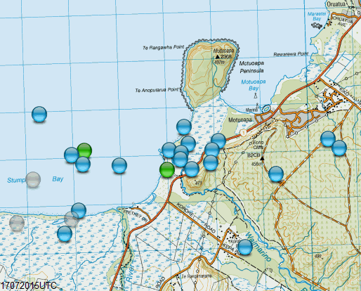
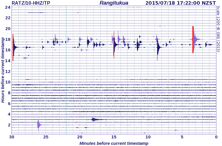
those Red traces aren't part of this swarm, there were a few M3's elsewhere in the NI.
NZTopoMap is down HTTP Error 503. service is unavailable, for me right now, so here's the Bing Map version, that biggest Red trace must be the 3.4 over towards Hawke Bay (#1 on the list)
www.bing.com...://dl.dropboxusercontent.com/u/1132313/2015/Jul17.kml
further to: muzzy
In fact that site has quite a good recent historical record of Tsunamis, back to 2002 anyway.
So I have utilized it, and added 12 new items to the comments column in the 2015 file for a start.
A 0.1m -0.4m Tsunami probably doesn't mean much to most people who don't know the locations, but if it is somewhere you live or have visited yourself it then becomes relevant. Even 0.4m (1.3ft) of water can do a lot of damage if it is traveling fast enough.
Always handy to have for the records anyway.
example; (too bad I can't colourize the text in the actual Bing Map, Bing doesn't take to HTML code as well as Google Classic maps did)

M3.8 - Off the coast of Oregon
Time
2015-07-19 18:46:17 (UTC)
Nearby Cities
384km (239mi) W of Waldport, Oregon
398km (247mi) WNW of Coos Bay, Oregon
443km (275mi) W of Dallas, Oregon
447km (278mi) W of Corvallis, Oregon
466km (290mi) W of Salem, Oregon
earthquake.usgs.gov...
Time
2015-07-19 18:46:17 (UTC)
Nearby Cities
384km (239mi) W of Waldport, Oregon
398km (247mi) WNW of Coos Bay, Oregon
443km (275mi) W of Dallas, Oregon
447km (278mi) W of Corvallis, Oregon
466km (290mi) W of Salem, Oregon
earthquake.usgs.gov...
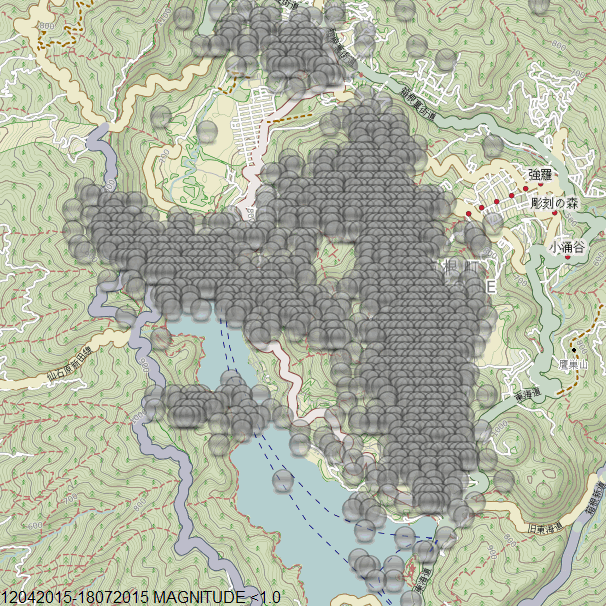
It has probably already happened yesterday, the 2606th earthquake at Hakone, Honshu, Japan since 12/04/2015
so far there has been;
mag~1= 1988
mag1= 471
mag2= 37
mag3= 3
total= 2499
TTNT= 6.817
The Volcanic status is still: Near-crater warning, Level 3 (Do not approach the volcano), originally issued 12:30 JST, 30 June 2015
Timeline graph 97 days
rightclickviewimage for full size (1538 pixels wide)

MAPS
All
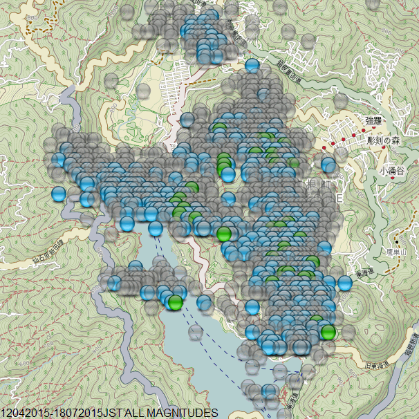
All above M2
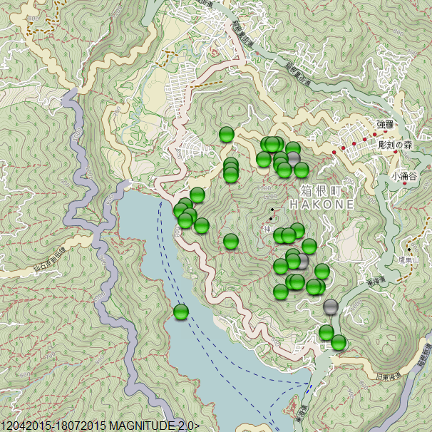
All above M1
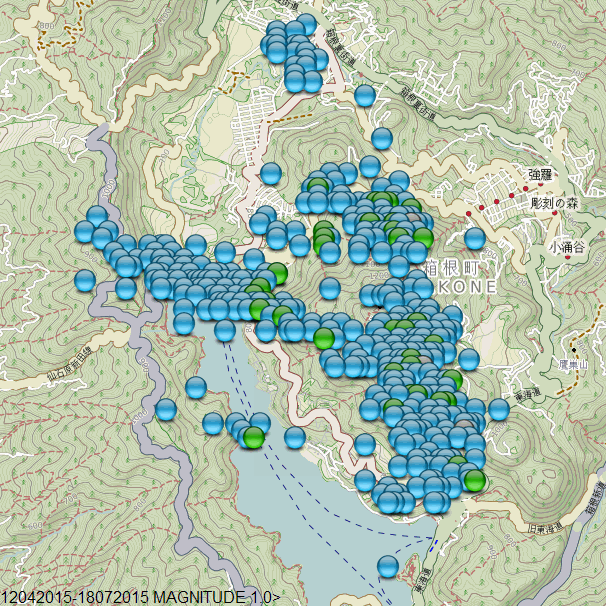
All below M1
so far there has been;
mag~1= 1988
mag1= 471
mag2= 37
mag3= 3
total= 2499
TTNT= 6.817
The Volcanic status is still: Near-crater warning, Level 3 (Do not approach the volcano), originally issued 12:30 JST, 30 June 2015
Timeline graph 97 days
rightclickviewimage for full size (1538 pixels wide)

MAPS
All

All above M2

All above M1

All below M1

edit on 0700000019919915 by muzzy because: (no reason given)
Looks as if the Greek network has succumbed to the problems in that country. No data since the 18th on the monthly list and the recent alerts stop at
the 9th.
a reply to: PuterMan
When i seen your name I thought you had come on for this;
the 3rd quake over M3 in the English Channel this year
statement based on this site
www.seisme.prd.fr...
too bad about NOA, probably haven't been paid for months
looks like the UNIVERSITY OF THESSALONIKI of has shut down too, 15/7 the last entry
geophysics.geo.auth.gr...
When i seen your name I thought you had come on for this;
the 3rd quake over M3 in the English Channel this year
Magnitude ML 3.2
Region FRANCE
Date time 2015-07-19 14:05:32.8 UTC
Location 49.80 N ; 0.52 E
Depth 2 km
Distances 170 km NW of Paris, France / pop: 2,138,551 / local time: 16:05:32.8 2015-07-19
58 km NW of Rouen, France / pop: 112,787 / local time: 16:05:32.8 2015-07-19
9 km W of Cany-Barville, France / pop: 3,463 / local time: 16:05:32.8 2015-07-19
www.emsc-csem.org...
statement based on this site
www.seisme.prd.fr...
too bad about NOA, probably haven't been paid for months
edit on 0700000019919915 by muzzy because: (no reason given)
looks like the UNIVERSITY OF THESSALONIKI of has shut down too, 15/7 the last entry
geophysics.geo.auth.gr...
edit on 0700000019919915 by muzzy because: (no reason given)
I was doing some reading today, and came across this article. Since John Vidale has posted here At ATS, I thought some of you might appreciate
this.
theextinctionprotocol.wordpress.com...
As for the topic of the article, the reality of the senario scare's the day-lights out of me. But we can't live in fear of the unknown. Life will go on. If you live in the PNW, please take personal responsiblity and make sure you are prepared as best as you can.
edit on 19-7-2015 by
crappiekat because: (no reason given)
5.8 SOUTHERN EAST PACIFIC RISE (Depth 2)
1 H 20 min ago
1 H 20 min ago
edit on 20-7-2015 by Eagleyedobserver because: (no reason given)
4.4 OFFSHORE GUATEMALA (depth 71)
41 minutes ago
41 minutes ago
edit on 20-7-2015 by Eagleyedobserver because: (no reason given)
M 4.4
15km ENE of Cherokee, Oklahoma
2015-07-20 20:19:04 (UTC)
Nearby Cities
15km (9mi) ENE of Cherokee, Oklahoma
53km (33mi) NNW of Enid, Oklahoma
99km (62mi) W of Ponca City, Oklahoma
107km (66mi) WSW of Arkansas City, Kansas
160km (99mi) NNW of Oklahoma City, Oklahoma
earthquake.usgs.gov...
That's a little bigger than the norm...
a reply to: Darkblade71
felt a little bigger than that... even my dogs "alerted" on this one.
I thought we`d had another 4 pointer here in Arkansas from the rattles etc.
felt a little bigger than that... even my dogs "alerted" on this one.
I thought we`d had another 4 pointer here in Arkansas from the rattles etc.
a reply to: dragonlover12
I'm watching to see if it is upgraded.
There was a 3.2 just a little bit ago.
M3.2 - 8km WNW of Pawnee, Oklahoma
Time
2015-07-20 20:50:16 (UTC)
Nearby Cities
8km (5mi) WNW of Pawnee, Oklahoma
32km (20mi) NNE of Stillwater, Oklahoma
40km (25mi) SSE of Ponca City, Oklahoma
73km (45mi) NE of Guthrie, Oklahoma
115km (71mi) NNE of Oklahoma City, Oklahoma
earthquake.usgs.gov...
Seems kinda active today
Now a 4.0!
M4.0 - 17km NE of Cherokee, Oklahoma
Time
2015-07-20 20:54:32 (UTC)
Nearby Cities
17km (11mi) NE of Cherokee, Oklahoma
57km (35mi) NNW of Enid, Oklahoma
100km (62mi) W of Ponca City, Oklahoma
106km (66mi) WSW of Arkansas City, Kansas
164km (102mi) NNW of Oklahoma City, Oklahoma
earthquake.usgs.gov...
I'm watching to see if it is upgraded.
There was a 3.2 just a little bit ago.
M3.2 - 8km WNW of Pawnee, Oklahoma
Time
2015-07-20 20:50:16 (UTC)
Nearby Cities
8km (5mi) WNW of Pawnee, Oklahoma
32km (20mi) NNE of Stillwater, Oklahoma
40km (25mi) SSE of Ponca City, Oklahoma
73km (45mi) NE of Guthrie, Oklahoma
115km (71mi) NNE of Oklahoma City, Oklahoma
earthquake.usgs.gov...
Seems kinda active today
edit on 20-7-2015 by Darkblade71 because: (no reason given)
Now a 4.0!
M4.0 - 17km NE of Cherokee, Oklahoma
Time
2015-07-20 20:54:32 (UTC)
Nearby Cities
17km (11mi) NE of Cherokee, Oklahoma
57km (35mi) NNW of Enid, Oklahoma
100km (62mi) W of Ponca City, Oklahoma
106km (66mi) WSW of Arkansas City, Kansas
164km (102mi) NNW of Oklahoma City, Oklahoma
earthquake.usgs.gov...
edit on 20-7-2015 by Darkblade71 because: (no reason
given)
a reply to: Darkblade71
Hmm... the term "Fracking Idiots" was pretty popular around here a couple of years ago
Thanks for the updates!
ETA... the webi closest to me (just a few miles) shows them pretty well www.iris.washington.edu...
Hmm... the term "Fracking Idiots" was pretty popular around here a couple of years ago
Thanks for the updates!
ETA... the webi closest to me (just a few miles) shows them pretty well www.iris.washington.edu...
edit on 20-7-2015 by dragonlover12 because: (no reason
given)
new topics
-
The daily fail trying to imply “it’s aliens”
The Gray Area: 18 minutes ago -
Swarms of tiny 'ant-like' robots lift heavy objects and navigate obstacles
Science & Technology: 1 hours ago -
NYPD Chief Jeffrey Maddrey Resigns - Forced Officers to Give Sex for Overtime Pay and Favors.
Posse Comitatus: 2 hours ago -
The Carpet Coating that Attacked the Environment
Medical Issues & Conspiracies: 6 hours ago -
Microplastics in your drinks
Medical Issues & Conspiracies: 8 hours ago
top topics
-
The Carpet Coating that Attacked the Environment
Medical Issues & Conspiracies: 6 hours ago, 11 flags -
China Working on 'Drone Mothership' Plane
Military Projects: 13 hours ago, 10 flags -
Microplastics in your drinks
Medical Issues & Conspiracies: 8 hours ago, 5 flags -
Happy Rush Day 2024 - 2112
Music: 13 hours ago, 4 flags -
12-21-24 Usyk-Fury II
World Sports: 16 hours ago, 1 flags -
NYPD Chief Jeffrey Maddrey Resigns - Forced Officers to Give Sex for Overtime Pay and Favors.
Posse Comitatus: 2 hours ago, 1 flags -
Swarms of tiny 'ant-like' robots lift heavy objects and navigate obstacles
Science & Technology: 1 hours ago, 1 flags -
The daily fail trying to imply “it’s aliens”
The Gray Area: 18 minutes ago, 0 flags
active topics
-
Just spotted an unusual aircraft Melbourne Australia
Aliens and UFOs • 7 • : Cavemannick -
Swarms of tiny 'ant-like' robots lift heavy objects and navigate obstacles
Science & Technology • 2 • : BeyondKnowledge3 -
The daily fail trying to imply “it’s aliens”
The Gray Area • 0 • : Cavemannick -
Post A Funny (T&C Friendly) Pic Part IV: The LOL awakens!
General Chit Chat • 7942 • : imitator -
An Interesting Conversation with ChatGPT
Science & Technology • 32 • : Sasquatch1111 -
Drones everywhere in New Jersey ---and Elsewhere Master Thread
Aliens and UFOs • 221 • : imitator -
Donald Trump Should Offer AMNESTY to the BIDEN FAMILY For Indicting Blackmailers-Controllers.
US Political Madness • 78 • : WeMustCare -
JOSEPH BIDEN Says Democrat Coup Leaders Forced Him to Resign the Presidency - Eff 1.20.2025.
2024 Elections • 55 • : WeMustCare -
Democrat Leader Hakeem Jeffries Promotes HATE After 2nd Attempt to Murder Trump in 2024.
US Political Madness • 41 • : WeMustCare -
Flying saucer spotted during the Trump assassination attempt
Aliens and UFOs • 66 • : WeMustCare
