It looks like you're using an Ad Blocker.
Please white-list or disable AboveTopSecret.com in your ad-blocking tool.
Thank you.
Some features of ATS will be disabled while you continue to use an ad-blocker.

Dulce Base South Entrance Found!?
page: 4share:
An entrance to the underground base. I'll draw you a drawing if you like.
Theres a river running through a medium canyon, stay on the river till you get to a place thats almost formed an ox bow lake (Almost, not fully formed yet.) On the left will be a sandy stretch of beach with a 100 foot wide opening into a cayon off shoot. The canyon goes up into the red wood trees quite steeply, but just as you get half way up it flattens into a large 500 feet across and about 1000 feet deep area in between the continuing tree line. Ill draw a drawing of it for you all, as i would love to find this place on satellite imagery - The way in and out is vertical take off craft ie helicopter - but be aware that this is not the main entrance to the underground base, but a special access area for rapid deployment troops and medical evacuations. The main entrance is far too far away and is reached by under ground road system. The trucks and cars are all electric to prevent poisoning from exhaust fumes.
Ill draw the picture and link it for you.
I hope this helps.
heres what your looking for.
img164.imageshack.us...
[edit on 18/7/06 by GSA]
[edit on 18/7/06 by GSA]
Where is the medium canyon? Need some idea of the location in relation to Dulce town.
Thanks
Thanks
sorry its a canyon about 300 feet across, not very big as the drawing shows...
look for the oxbow kink in the river and you have your entrance. Well one thats used if theres no bulky equipment to be taken in by transport.
Ill have a look for a good map of the area and will try and high lite it for you.
look for the oxbow kink in the river and you have your entrance. Well one thats used if theres no bulky equipment to be taken in by transport.
Ill have a look for a good map of the area and will try and high lite it for you.
Originally posted by Jimmy910130
This is similar to the movie 'The Hills Have Eyes'...Good thing you didn't take the 'scenic' route the cowboy said or you would've ended up being killed by mutants.
''I've heard that people in Dulce are afraid of what's going on at the base. ''
Uh oh, getting even starnger...
AAAHHHH! That is just what I need right now! This is just to coincedental. All of the underground bases are acutally buried cities where atomic tests used to take place, and anyone who tries to venture their gets kidnapped and tortured by ugly deformed mutants! Oh God!!!!
You are very dense. Why would I waste my time writing that? Go stay at the hotel/casino there and see for yourself.
To anyone interested in the symbology on the white vehicles passing me on the way there...half clocks, noon to 6. Has anyone seen this symbol used before?
I have searched for the place you described, GSA. But i have nothing found.
Can you give the coordinates or post a pic of that place, plz?
Can you give the coordinates or post a pic of that place, plz?
I Found an Entrance to Dulce.
.www.abovetopsecret.com...
But then the moderator shut down the thread
.www.abovetopsecret.com...
But then the moderator shut down the thread
The thread is still open as i just posted there several minutes ago...
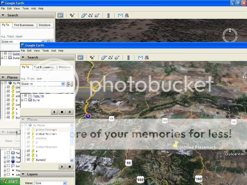
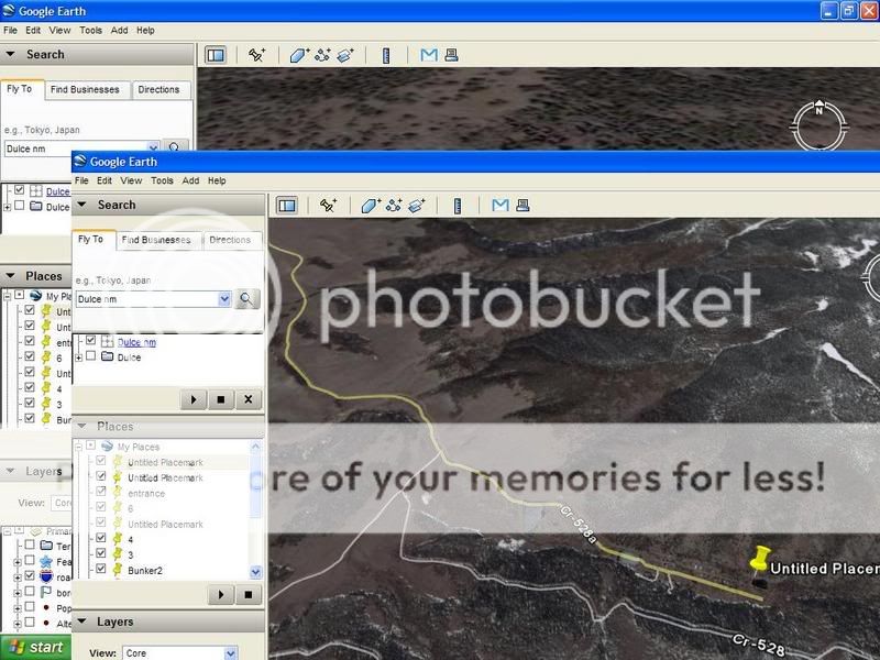
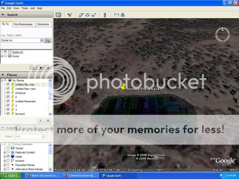
ojk i found something weird in the moutians north of dulce the city go to these excact cordnance and zooom in its a blacked out area and you can make
out a building not to mention its at the end of a rd called cr-52a
[edit on 27-11-2006 by semperfi221]
[edit on 27-11-2006 by semperfi221]
Glad to see that people are still looking for the entrance. That image looks like something rather large and complex like an entrance to a base. I
wonder if this is disguised at ground level as something else?
Originally posted by allMIGHTY
The coordinates are 36°58´55´86 N - 106°57´42´37 W.
Try to find it, but Google Earth provides only poor imagery of this area. Try it
with Virtual Earth.
I know that i am not often reply or post something last time. This is because
i became a father since february. I had not much time the last months. SRY!

Terra Server USA is much better. You can Zoom pretty much enough to see ppl on the streets..lol
I had a quick look at the place... not very big. But theres a couple of roads outside the town that don't seel to go amywhare..
Oh and something that looks really strange, while using that map at maximum zoom on arial potot setting, go to these Co-ordinates..
-106.97529 - 36.94143
As the satalite maps these areas, it usually dose it one little bit at a time, each time it passes over.
Thus you ger a variation in the color of each area as it passes over at different times of the day.
Notice that the large Square area in this zoom is not only lighter in color than all the other areas "well thats no big deal, it might have passed over on a sunny day".
But, look round the edges of this light square area. It's been overlayed "very shabily", to obscure another view of the area at a different time.
Why would someone do that do you think?
Though i could be mistaken, i'm not really familliar with the area, this could be a part of the reservation or something.
But still, strange to overlay a tiny area like that with a different photo.
[edit on 28-11-2007 by Ironclad]
[edit on 28-11-2007 by Ironclad]
About the only thing you are going to accomplish out in the Dulce area is pissing off some local land owners or managing to get yourself
scalped for trespassing on Tribal Lands!!!!!!!!!!!!!!!!!!
your coordinates are BS, Oooooooooooooooooooo you must be so smart as to try and fool me... Turds, check out your #e before you post it
Very interesting thread.
I have something to add. I used to live with a man that worked at Area 51, which gives me certain insights. Entrances to large installations are always adjacent to public airports, train stations, etc. The reason for this is that people have to look normal to their neighbors, etc. They have to get in their car and drive to work like everyone else. They do so, but they paas through a restricted gate and park their vehicle where it will remain under 24 hour guard until they return. From there, they walk into the terminal. At McCarran Airport for Area 51, they take the Janet planes, it looks like an small executive airstrip off to the side of the airport. I assume for underground facilities there may be underground terminals accessed by underground parking instead.
The concept I am trying to get across is that these people will drive their car into an area that is heavily travelled, a public hub, then they simply drive through the restricted gate. Large numbers of cars will not stand out in this area.
Look for restricted parking areas in or adjacent to airports, train stations, any major transportation hub with large parking facilities that naturally cater to large numbers of people daily.
The man I lived with left the house at 5am Monday morning and returned Thursday at 6pm. I learned many interesting things from him. from what I know, these hubs could be hundreds of miles away. The technology that is used in the elevators (magnets) is also used for the underground transportation system, which moves at lightning speed..
EDIT: Added info, fixed typo.
[edit on 25-7-2008 by Pithiny]
I have read almost the lot about this base, but is it there? Lets see if i can make some "CIA" ears stand up! lol
If there was a base there, there wouldn't have to be any spoil heaps left from the digging out it could have be taken to Los Alamos via the tunnel systems then disposed of to keep the base secret.. It would also be hard to "nose around" the area due the Ute Indian restrictions in the area not sure if you can get around this with a pay off.. Not to forget the mountain lions that are there too.. If the base is there it would need infrastructure. Air, Water, Power.. Power can be made in house so there would be no signs, But there must be some kind of air con systems in place which would look odd in the middle of nowhere, water you would need a lake or river unless it has an underground spring. Also there must be a huge magnetic field in the area too which can be tested using a magnetometer (i think) or you could use a compass as the needle would spin like mad.. an easy test to do....
Any government cars in Dulce town, if so what areas are they in?
RAND CO, i found that RAND had been in business since 1981 (If i was looking at the correct site) so did they really do the early dig's on the base levels one and two? i done a search on RAND web site regarding Ducle but no results.. Any RAND workers here wanna tell all?
Also have you noticed the sightings of "big foot" in there area aswell on the google map!! Supposed underground base and Big Foot sightings coincident!
Is there any base works that have come forward apart from the ones that already have? any one have any emails or contacts? Whats happening in 2008 at Dulce base?
[edit on 3-8-2008 by solme]
[edit on 3-8-2008 by solme]
reply to post by GSA
GSA, you still are not saying which direction from Dulce is the spot you are talking about. Is it North of Dulce ? east, west, south ? which river ? how many miles from the center of town ? Even if you don't have the coordinates, which would be very helpful, you would still be able to tell us enough for us to find it. From the river, looking at this spot, which direction would the morning sun be ? There's lots of ways to help us pin-point it down. Being vague doesn't help. The reservation names their roads J1, J2, J3, etc. is it between two particular roads ? is it west or east or north or south of a particular road. How many miles did you travel on the particular road from town ?
Help us out GSA.
I agree with the above post, its 2008 whats poppin out there, i only live a couple hours from there ive been thinking about going out there and
conducting a noob investigation, dulce has always facinated me to the point of insanity haha i just dont wanna go out there with no idea of where im
going, yeah i can go roam the mesa but whats that gunna prove, if anyone can fill me in on where i might wanna go look ill be glad to go out there
with video equipment and lay this rumor to rest once and for all if possible.
that area is just some drainage ponds......... nothing there but some random sheep and some old cabins. Its right before the entrance to the
Jicarilla Reservation. I think it used to be used as some fisheries with the game and fish a while back....... Nothing there to see.
Originally posted by watch_the_rocks
Wow. Good work. It would appear that there is definitely something there, possibly an entrance. Now all we need is someone from ATS to trundle up to the place and check it out, ignoring the possibilities of getting shot or dragged underground for bio-genetic manipulation. Yay.
I love the excitement in your post, because that was exactly what Iwas thinking. Ha ha. I wouldn't mind sacrificing myself, because if I did get drug under for experiments at least I would know it's true....
new topics
-
DARPA Releases First Images Of Manta Ray Underwater Drone During In-Water Testing
Military Projects: 5 hours ago -
I'm back...sort of
Introductions: 5 hours ago -
October 7th: The Crumbling Facade of a Western Security Asset
Above Politics: 7 hours ago -
Echoes of Colonialism: The Struggle for Space and Speech in Academic Institutions
US Political Madness: 7 hours ago -
VIDEO INSIDE CIA: Project Manager Says Execs and Directors of CIA Withheld Information From Trump
US Political Madness: 9 hours ago -
Richard Tandy ELO R.I.P.
Music: 10 hours ago
top topics
-
ICJ Did NOT Find There Was a Plausible Case That Israel Is Committing Genocide
World War Three: 12 hours ago, 11 flags -
White House considers welcoming some Palestinians from war-torn Gaza as refugees
US Political Madness: 16 hours ago, 10 flags -
DARPA Releases First Images Of Manta Ray Underwater Drone During In-Water Testing
Military Projects: 5 hours ago, 7 flags -
I'm back...sort of
Introductions: 5 hours ago, 5 flags -
VIDEO INSIDE CIA: Project Manager Says Execs and Directors of CIA Withheld Information From Trump
US Political Madness: 9 hours ago, 4 flags -
The Pentagon is lying about UFOs
Aliens and UFOs: 12 hours ago, 3 flags -
Israel's plans for the West
Above Politics: 13 hours ago, 3 flags -
October 7th: The Crumbling Facade of a Western Security Asset
Above Politics: 7 hours ago, 3 flags -
Richard Tandy ELO R.I.P.
Music: 10 hours ago, 3 flags -
Who I am is me.
Introductions: 15 hours ago, 2 flags
active topics
-
US drug control agency will move to reclassify marijuana in a historic shift, AP sources say
Breaking Alternative News • 63 • : daskakik -
Krystalnacht on today's most elite Universities?
Social Issues and Civil Unrest • 46 • : SchrodingersRat -
White House considers welcoming some Palestinians from war-torn Gaza as refugees
US Political Madness • 36 • : Asher47 -
James O’Keefe: I have evidence that exposes the CIA, and it’s on camera.
Whistle Blowers and Leaked Documents • 46 • : SchrodingersRat -
The Pentagon is lying about UFOs
Aliens and UFOs • 13 • : Jukiodone -
Civil War in Texas Say Chinese Media
General Conspiracies • 62 • : SchrodingersRat -
College protesters want amnesty.
US Political Madness • 192 • : RAY1990 -
Richard Tandy ELO R.I.P.
Music • 5 • : angelchemuel -
German city in chaos as 'extremist' march sees calls for 'caliphate' and ISIS-style flags
Mainstream News • 43 • : SchrodingersRat -
Echoes of Colonialism: The Struggle for Space and Speech in Academic Institutions
US Political Madness • 26 • : Asher47