It looks like you're using an Ad Blocker.
Please white-list or disable AboveTopSecret.com in your ad-blocking tool.
Thank you.
Some features of ATS will be disabled while you continue to use an ad-blocker.

Definitive 9.11 Pentagon EVIDENCE.
page: 6share:
www.abovetopsecret.com...
Here below I proved the 'South plane shadow' theory of CausticSoda/FrustratingFraud wrong.
www.abovetopsecret.com...
www.abovetopsecret.com...
www.abovetopsecret.com...
Quite interesting post, filled with pictures :
www.abovetopsecret.com...
Now this is an interesting one, keep in mind what we know now (90 degrees impact).
www.abovetopsecret.com...
The victims pattern does "not fly" with the official 61.25 degrees true north plane debris entrance path at all.
That debris must have made a sudden 30 to 60 degrees deviation, to have been able to make that deadly damage in that far right corner of the C and D Ring in Wedge I.
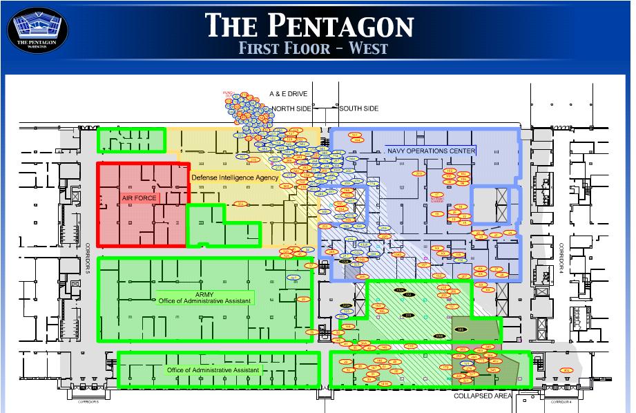
The Navy and ONI offices were also situated there, and also look at the casualties found ALL flocked in front of closed doors there...They couldn't escape, the electrical safety door locks must have been locked...intentionally.? They died from smoke inhalation, I suppose.
Were there any death certificates for these specific victims? Smoke in their lungs as the cause of death, or brain and internal organs concussions? From thermobaric bombs...
And those light poles were for sure already weeks ago preserved with small C4 packs.
Remotely ignited, just before impact.
Here below I proved the 'South plane shadow' theory of CausticSoda/FrustratingFraud wrong.
:
I proved him wrong years ago already, in thinking that it could be the shadow of a south of CITGO flying plane, since the timestamps in the CITGO cameras windows at the moment he "saw" that "shadow" were about 4 to 6 seconds out of sync with the impact time and the distance flown to impact. He conceded to that fact.
www.abovetopsecret.com...
www.abovetopsecret.com...
www.abovetopsecret.com...
Quite interesting post, filled with pictures :
www.abovetopsecret.com...
Now this is an interesting one, keep in mind what we know now (90 degrees impact).
Instead of AA77, think about some shaped charges inside, planted already during the last renovation days or weeks in these specific renovated NAVY and ONI rooms with their top secret mainframes that the PLANNERS needed to shred to thousand pieces. The ones with all the incriminating evidence from decades past, about THEM and their wealthy co-conspirators.
Look at the strange victims pattern in the far right (blue here) NAVY offices corner of the official damage path. To be found in the Pentagon Aftermath Report. I have it saved :
www.abovetopsecret.com...
The victims pattern does "not fly" with the official 61.25 degrees true north plane debris entrance path at all.
That debris must have made a sudden 30 to 60 degrees deviation, to have been able to make that deadly damage in that far right corner of the C and D Ring in Wedge I.
The Navy and ONI offices were also situated there, and also look at the casualties found ALL flocked in front of closed doors there...They couldn't escape, the electrical safety door locks must have been locked...intentionally.? They died from smoke inhalation, I suppose.
Were there any death certificates for these specific victims? Smoke in their lungs as the cause of death, or brain and internal organs concussions? From thermobaric bombs...
And those light poles were for sure already weeks ago preserved with small C4 packs.
Remotely ignited, just before impact.
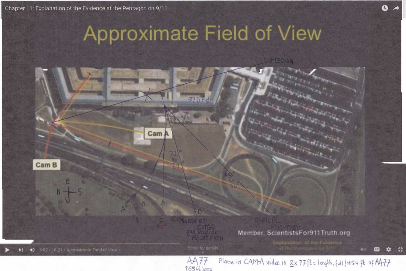
This is MY calculation that covers the REAL turn radius, speeds and banks as SEEN at NoC and covering all 23 NoC witnesses.
Aircraft speed of 230 KTS (265 MPH) entering a 34.94° bank angled turn with a turn radius of circa 2 KM (2053 meters = 6736.2 feet) :
Read more pages, it's getting more and more, very interesting, especially now you know for the first time about the real attack flight path of AA77, it was on a ~ 90 degrees impact path.
Because you can check now at last, with your own perhaps wavering eyes, the length of AA77 as officially registered by the 2 security cameras at the DoD's Northern Parking Entrance of the Pentagon. Made public in 2006, via a FOIA request.
And if you still don't get it:
The full length that was registered thus give you only one chance, namely to conclude that AA77 flew straight at ~90 degrees to the Pentagon's West Wall, then impacted there.
Aircraft speed of 230 KTS (265 MPH) entering a 34.94° bank angled turn with a turn radius of circa 2 KM (2053 meters = 6736.2 feet) :

Thus, officially we have no further endorsed flight data then the NTSB one, up to that position beside the Sheraton Hotel.
The rest of AA77's flight trajectory could be anything manageable and imaginable by a good pilot in a 757-200 :
AT ANY SPEED which would keep the plane flying, so, above its registered stall speed. It could easily do so in my proposed trajectory curvature.
And the 4 ANC maintenance workers all 4 told us in their videos, that the plane came slowly over the ANC roofs, turned slightly before their eyes above the ANC (Arlington National Cemetery) parking and then was pushed full throttle. And Terry Morin too, and Sean Boger too, etc.
Especially the 2 CIT video-interviews with William Lagasse and Chadwick Brooks, the two Pentagon Police agents at the gas pumps in the CITGO's northern pumps area, are blood chilling, these two bet their life on it in 2006 that they were 100% sure, that they saw that plane flying very low and very close to them, at the northern side of the CITGO gas station (now NEX gas station).
AND THESE 2 ARE STILL ALIVE, afaIk (as far as I know).
Read more pages, it's getting more and more, very interesting, especially now you know for the first time about the real attack flight path of AA77, it was on a ~ 90 degrees impact path.
Because you can check now at last, with your own perhaps wavering eyes, the length of AA77 as officially registered by the 2 security cameras at the DoD's Northern Parking Entrance of the Pentagon. Made public in 2006, via a FOIA request.
And if you still don't get it:
The full length that was registered thus give you only one chance, namely to conclude that AA77 flew straight at ~90 degrees to the Pentagon's West Wall, then impacted there.
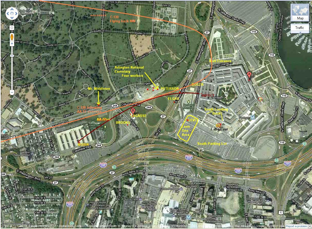
Path C is the North of CITGO gas station flight path, told by >36 eyewitnesses.
Partly interviewed, f.ex. on video by CIT (citizens investigation team), done by Craig Ranke and Aldo Marquis, forming the CIT-team; and 22 phone interviews Jeff Hill did with Pentagon 9/11 witnesses; and I myself found many more online, by journalists and 9/11 researchers globally.
The North of CITGO flight path by AA77 is thus now proved 100 % true.
Proved 100 % true by the DoD's own, in 2006 publicized, two camera views from their own 9/11 security cameras recordings, of an incoming AA77 over the lawn in front of the Pentagon's West wall.
In 2015 at last publicly corrected and made viewable to their 100 % real-life dimensions , by the work of David Chandler and former work by Ken Jenkins. David used the GIMP drawing and video mastering program he did buy in 2015. From that moment on, everybody with some logical working mind, could have seen the proof in the pictures, of Cam2 and Cam1.
Strangely enough, no one seems to have seen the logical conclusion of a simple measurement of plane and West wall height in his corrected AA77 flying to the wall, video scenes.
The corrected AA77 plane length of 154 ft, easily measurable now at last in 2015, by comparing its length to the West wall's known height of 77 ft, shows that the now in real life dimensions observable plane length, was 2 x the wall height.
Thus seen in full length, thus flying perpendicular to that wall, and also seen by the 2 cameras as flying with its northern side length, perpendicular to the 2 cameras too.
Since an eventually at 45 degrees incoming, officially defended, flight AA77 would have been registered by the same 2 cameras as 70 % shorter, ~109 ft.
That would have seemed to be 30 % shorter then AA77 its known full length of 154 ft.
No one of the typical 9/11 truth debunking members seems to even want to touch this main subject of this thread, the EVIDENCE...very telling.!
All your years of stubborn defending of the (OS), the Official Story :
Wasted, gone, and fainting away, as mist in time.
Thank you all, for your clear, however reluctantly honest, message :
WE HAVE NO DEFENSE against this 2006 evidence, given by the perpetrators themselves.
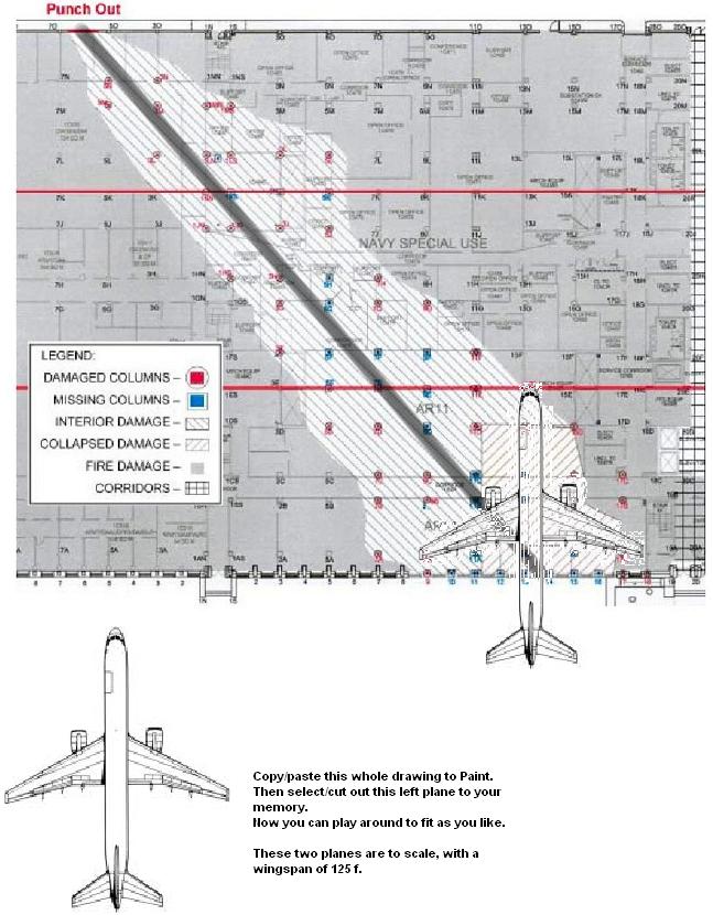
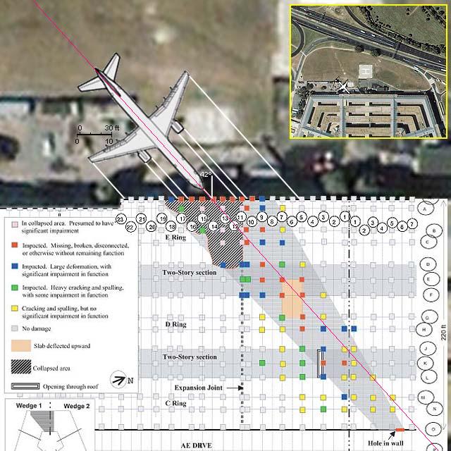
This diagram is what must have happened in the Pentagon on 9/11 in reality.
AA77 flies head-on into the West wall at column 14, its debris goes no further than that thick red line. Note the 3 red colored damaged columns, situated out of the damage zone. Note also the shape of the right side of the collapse zone. The right engine made that damaged collapse profile. And the right wing fits the right side of the collapse profile.
The left collapse profile follows the double columns line, and the left engine's course. If you mirror the collapsed part to the left, it would fit the same space as in the right collapsed part.
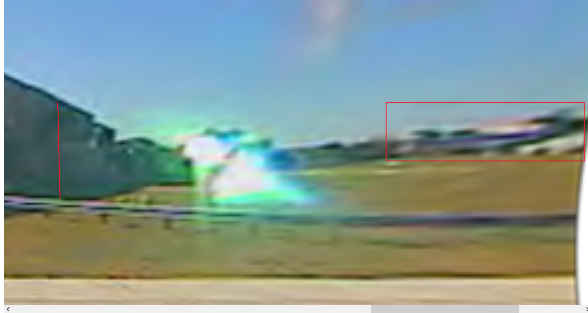
Sadly, I have no -early- photographs at all, from that first collapsed part and its mirror space, up to that red line. We have a strange photo from long after the clean up, where you see an unscratched concrete floor in that first part.
The rest of that 52 degrees damage path, up to the clearly made by explosives, entrance hole in the C rings outer brick wall, that path has been exploded, not caused by airplane debris. Could have been made by one or more directional thermobaric bomb(s), inside the plane.
There must have been some very sleep disturbing material, and men and woman, in those destructed ONI and NAVY offices in the 52 degrees path, causing those 9/11 planners many sleepless nights, during a nasty long time of meticulous planning.
A probable flightpath of AA77, flown at ~ 265MPH, banking at a 34.94° bank, up to where it got full throttle while passing along the 4 ANC workers,
and up to there, with a turn radius of 2053 m.
Then it was pushed full throttle while banking a bit more to the right, wobbling a bit, to end up at ~ 90° at column 14 in the West wall :
Again, use Zoom, or 10 times push your keyboard its 2 keys together Ctrl and +
Then it was pushed full throttle while banking a bit more to the right, wobbling a bit, to end up at ~ 90° at column 14 in the West wall :
Again, use Zoom, or 10 times push your keyboard its 2 keys together Ctrl and +
originally posted by: LaBTop
We have a strange photo from long after the clean up, where you see an unscratched concrete floor in that first part.
No evidence of any explosives then.
I never served in a military office building with a concrete floor. I served in a military buildings where there was tile, linoleum, Terrazzo layers as a decorative/protective covering over a concrete subfloor.
So the floor was damaged to the point it had to be stripped down to the concrete. And the concrete made right to accept a new floor. Do go on…
a reply to: LaBTop
How about you screenshot and circle the clearly visible scratches on this belly landing right on the runway?
How about you screenshot and circle the clearly visible scratches on this belly landing right on the runway?
Scottsdale plane belly-landing
m.youtube.com...
Just get to the meat of the matter, THE EVIDENCE.
And don't throw in another bunch of distracting posts, that's well known forum killing technique, called nudging.
Read MINDSPACE, it's in one of the earlier pages.
Don't act as if you don't understand it, a 6 year old understands it immediately, after some further reading than the first post, with that cut-off picture. Here's the full picture, as it should be in my OP :
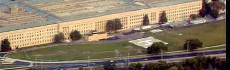
The most recent photo I have found, from just a short time before 9/11, of the West wall.
With the lawn, Helicopter-pad, Heli-Controll Tower, part of Route 27 (Washington Boulevard) and that 4 stories high, green tree, a few meters to the right of that white squared Heli pad, and growing in front of the West wall its column 14, where AA77 slammed straight into.
Optical illusion again seems to show that from the two trees along Route 27 and in front of the Helipad with that white H painted on, its right one seems to block a 90 degrees incoming AA77.
Not true, in fact AA77 could clear that tree with enough space left, on a 90 degrees attack path. Just view one of my posted overhead photos.
This post I made in advance, for the types who keep acting as if they really don't understand the EVIDENCE :
This is in my OP, on page 1, my one really wrong scaled picture, caused by my rusty BB Codes formatting skills at ATS.
View it now, as it was meant to view. Perhaps a Mod or Admin can it now change it to how it was really meant : [pic]ct6390d458.png[/pic (left that last ] out for readability)
www.abovetopsecret.com... :
My above linked to, opening post (OP), its both pictures, this is what you should have seen as the second, full one Nr.2 :
Nr. 1 :
Nr. 2 :
Caused by optical illusion, it seems for the casual observer, that my upper horizontal red line length of the vague plane is not much longer than my vertical red line height of the West Wall at impact.
But if you take a ruler, or a compass / a pair of compasses / a pair of scissors, you'll find out that the measured plane's length red line, is twice the wall's height red line.
That's 2 x 77 ft = 154 ft, as Boeing specifies for the 757-200.
The DoD gave/gives 77 ft as the West wall's height.
That's half the plane's observed length by Cam 2, after at last being corrected by GIMP, and as used by David Chandler.
These are David Chandler's last lines of his 2015 explanatory texts on his page here :
911speakout.org...
LT : That new analysis is interesting too to view, adds some strong points to David's work.
911speakout.org...
This blinked image pair shows the motion of the plane between the two camera views using the corrected images. The images have been positioned so the background features on the horizon align. Based on the dimensions of the plane and motion relative to background markers, the plane moved about 115 ft between the two exposures. Using the FDR speed measurement of 556 mi/hr, we can compute that the two cameras were out of sync by about 0.14 sec. (I don't believe this time offset has been measured before.)
LT : AA77 did not fly in a straight line, at that ridiculous speed, read my above posts and view my proposed flight path beginning just after the Sheraton Hotel, turning slightly North passing about 50 m North of the CITGO gas station, passing those 4 ANC workers, just before there, it banked back right again, to be able to get its length straight onto the Pentagon West wall,and it could therefore fly absolutely not faster than ~ 260 MPH (mi/hr) in the first half of its small left banking turn, at a maximum ~35 degrees angle . It can only be possible, to become registered by Cam1 and 2 (CamA and B) at its full 154 ft length, thus incoming at that wall at 90 degrees, when it made that slight left banking turn to the ANC buildings, then made that new slight right banking turn there again, and then, when it was at its last 90 degrees attack path, got full throttled and slammed at a higher speed than ~260 MPH (How much? Your guess as good as mine. ) into that tree and behind it into column 14 of the Pentagon's West wall.
It is impossible to reach 556 MPH from ~ 260 MPH on that short track from the ANC buildings where the 4 workers saw it pass there in front of them, flying low between them and the CITGO gas station, and reported it banking to the right again in front of them and then throttled up full gas at about the Pentagon lawn. Measure it out yourselves.
David, with this new ~260 MPH speed, see my above posts, you or anyone else can now still not calculate the real out of sync time of those two cameras. Since we do not know the real exact speed over the lawn, where the 2 cameras picked up AA77, but it's surely a tad bit longer in seconds, then 0.14 sec. Because it did not fly in those few tens of meters of lawn, suddenly 296 MPH faster.
Because this all means that the radar reports you trusted were false, and about everything else the DoD, Government officials or FBI gave us ""officially"" as the truth, and nothing but the truth. Yep, sure...not.!!!
Note that when barrel distortion is eliminated, the image compression near the edge of the field is eliminated, so the plane appears longer, with proportions resembling a 757.
(Remember, the plane is also moving toward us at about a 45 degree angle.)
LT : David, you and I believed before 2015 both, that the ~45 degree attack angle for AA77 stood ironclad and non discuss able anymore... How wrong we were... !
The DoD their own material got them at the throat.!
After your exceptional GIMP work on their two DoD North Parking entrance's security cameras their video material, officially released by the DoD only in 2006 after 5 years of stalling a FOIA request, it at last made it possible to measure the now real AA77 length and West wall height, and suddenly, everything fell in place for me. I waited up till now, end of 2022, however, strangely enough, no one on Earth seems to have noticed the same as I did in late 2015, and now I can't wait any longer, time becomes uncountable short. The readers must stop these heartless murderers, and their madness.
Get some bravery back in those dulled minds, molded in 80 TV years of indoctrination, and think about how strong of character your granddad and granny, and moms and dads were in WWII and the years after, till TV came sneaking in.
Get it back. That sleeping bravery. It's still there.
ORGANIZE the masses. The only thing they are really afraid of.
One feature of the plane image helps us identify it as an American Airlines plane. Note the purple stripe along the side of the plane. American Airlines planes have parallel red and blue stripes. At the small scale of the original image it is quite likely that this purple stripe is a merger of the color information from a red and a blue stripe.
**********
NEW: Wayne Coste's analysis of the security camera videos extends what I have shown on this page. The blink comparator images below establish that a large plane approached the Pentagon. Wayne's analysis supports the authenticity of the videos and provides an independent assessment of the speed of the plane based on the security camera footage.
LT : That new analysis is interesting too to view, adds some strong points to David's work.
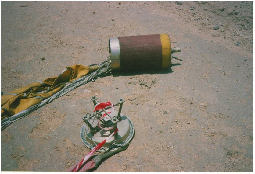
This is a parachuted, not exploded thermobaric bomb, the Russian army used in the war in Chechnya.
Type in ATS Search : LaBTop thermobaric
That will give you the posts and threads where it was the subject in.
When they used just a few directional bare explosives in the Pentagon, they created the spalling and bending of all these concrete rebar filled columns, that we saw in the few photographs.
THIS is, what kept me going on, all these long, still living, past years.
I strongly hope you all there, reading and viewing this, will wake up too.
I strongly hope you all there, reading and viewing this, will wake up too.
files.abovetopsecret.com...
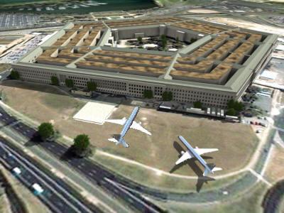
This is my internal damage pattern, a lot of some really strange green and yellow columns damage too there, to the left of that drawn in, darker damage path. It really looks like some sloppy explosives placements. And that hole in the outer C ring wall, that's not a punch-out hole, that's clearly a punch-in hole, the bricks damage along that broken out circle are all inward, from the outer corridor inwards. Had many posts about it :
In the upper right corner, in that yellow bordered, smaller and straight from above shot photo, you can clearly see that a 757 can come in at a ~ 90 degrees attack path, low flying, and not touch that left tree of the two along Route 27.
If you want many more NoCITGO eyewitness reports on camera or mike, read this full pg 1 :
www.abovetopsecret.com...
www.abovetopsecret.com...
2 Excerpts from 42 false flag articles :
www.whatreallyhappened.com...
(17) The NSA admits that it lied about what really happened in the Gulf of Tonkin incident in 1964 ... manipulating data to make it look like North Vietnamese boats fired on a U.S. ship so as to create a false justification for the Vietnam war.
(31) The U.S. falsely blamed Iraq for playing a role in the 9/11 attacks - as shown by a memo from the defense secretary - as one of the main justifications for launching the Iraq war. Even after the 9/11 Commission admitted that there was no connection, Dick Cheney said that the evidence is "overwhelming" that al Qaeda had a relationship with Saddam Hussein's regime, that Cheney "probably" had information unavailable to the Commission, and that the media was not 'doing their homework' in reporting such ties. Top U.S. government officials now admit that the Iraq war was really launched for oil ... not 9/11 or weapons of mass destruction. Despite previous "lone wolf" claims, many U.S. government officials now say that 9/11 was state-sponsored terror; but Iraq was not the state which backed the hijackers. (Many U.S. officials have alleged that 9/11 was a false flag operation by rogue elements of the U.S. government; but such a claim is beyond the scope of this discussion. The key point is that the U.S. falsely blamed it on Iraq, when it knew Iraq had nothing to do with it. ) .
To be allowed to enter "Washington's Blog", your connection must be secure, they check that first.
The problem at hand is that we far too easy say, that we as a lone person can't do anything about it, it's the way things go these days.
The moment you will realize that if a percentage of us that is bigger than 50 percent, will see it this way, we have arrived at, and completed, classical slave status...there is no such thing as a silent majority.
Only a brave, verbal matured, majority.
Can only be achieved by ORGANIZING same brave souls.
Avoid the already enslaved, they will automatically change camp, when the brave have united, in overwhelming and impressive numbers.
Another interesting page full of information about why and how 9/11 was planned and executed, and their planners protected, posted by me :
www.abovetopsecret.com...
After reading that, you may opt for the rest of the 121 pages.
www.abovetopsecret.com...
After reading that, you may opt for the rest of the 121 pages.
Double post
edit on 21-12-2022 by WhatItIs because: (no reason given)
Sadly, David Chandler (and many, many others) was, and so to see is, still duped by all this seemingly overwhelming official South of CITGO ~ 45
degrees flight path proof, of an in a straight line from Sheraton Hotel to Pentagon's West wall impact flying AA77 plane.
His excuse of course, up till my Evidence, is of course that pile of additional proof the Government and DoD came up with.
Well, when you see the Evidence that sits all these 7 years already in the 2006 released video material from the DoD, I certainly can and will not blame him, that he took for granted this crazy end speed the DoD's radar units, and Stutte's FDR last 4 - 5 seconds recalculation, came up with, of 586 MPH.
On that 568 MPH end speed is that whole 19:41 minutes below video from David based on, and I can't blame him doing that.
Now he will know better.
And I really hope he will, if he already read the first 6 pages of this thread by me.
Ask the new ATS owner, David, if you may use my Evidence material, I hope you can.
That AA77 plane can not have flown faster than 230 to max 265 MPH, to be able to make that left and then right banking maneuver, starting from Ed Paik's garage (to avoid that high steel radio mast, 30 meters south of the ANNEX buildings) and keep forces at under 1.5 G in that slight turn. My bank turn calculator proved that.
This below linked to video, is David's on 9 July 2022 released video, which I watched to the end, and heard nearly no mention of the 568 MPH acceptance of the end airspeed, based on Strutte's last 4 to 5 seconds garbled up FDR calculations, and out of those DoD radar unit's reports, where all the outcomes of his and Reheat and many other commercial and military pilots, reports and calculations, then had to conclude to. That crazy end speed of 568 MPH, as Strutte heralded. I surely do not believe his last 4 to 5 seconds FDR (flight data recording) calculations.
David, now, after reading all these 6 pages of Evidence, you know better : in reality it flew between 230 - 265 MPH maximum, in a very normal banking turn of ~ 28 to ~ 35 degrees bank, at ~ 1.2 G.
Just as the 4 ANC workers showed with a model airplane.
Title : Physical constraints on CIT's proposed flight path into the Pentagon.
This first video version (David : Obsolete Version / See notes), that David made about his calculations, and many more posters did the same, was purely just only based on that curious 568 MPH end speed.
For example ATS member Reheat's calculations were also resulting in the same idiot high banking turns and G-forces.
David also had to arrive, just as Reheat did, at those crazy banking angles of > 70 degrees and > 3 G's.(acceleration G force), when you used that 568 MPH end speed.
Now you know it was ALL part of that huge false flag operation.
That's still going on, after 21 long years.
They tripped over their own evidence, what a special gift of luck.
edit on 22/12/22 by LaBTop because: 1 years must be 21 years at the bottom.
new topics
-
Kirkpatrick vs Fugal - Skinwalker ranch briefing.
Aliens and UFOs: 3 hours ago -
Lemon-aid and lime-aid
General Chit Chat: 3 hours ago -
Multipal Solar Storms Coming Our Way This Weekend
Fragile Earth: 4 hours ago -
US food sources declining becoming non edible .
Social Issues and Civil Unrest: 6 hours ago
top topics
-
Bibi’s Dilemma
Middle East Issues: 16 hours ago, 11 flags -
Multipal Solar Storms Coming Our Way This Weekend
Fragile Earth: 4 hours ago, 7 flags -
US food sources declining becoming non edible .
Social Issues and Civil Unrest: 6 hours ago, 5 flags -
Journalism Against Judaism
Middle East Issues: 12 hours ago, 4 flags -
Lemon-aid and lime-aid
General Chit Chat: 3 hours ago, 2 flags -
Kirkpatrick vs Fugal - Skinwalker ranch briefing.
Aliens and UFOs: 3 hours ago, 1 flags
active topics
-
Multipal Solar Storms Coming Our Way This Weekend
Fragile Earth • 11 • : 727Sky -
Judge Postpones Trump Classified Docs Trial INDEFINITELY
US Political Madness • 173 • : Asher47 -
Pentagon UFO Hunter Reveals What He Knows About Aliens: Nothing
Aliens and UFOs • 16 • : Ophiuchus1 -
The Acronym Game .. Pt.3
General Chit Chat • 7819 • : bally001 -
-@TH3WH17ERABB17- -Q- ---TIME TO SHOW THE WORLD--- -Part- --44--
Dissecting Disinformation • 914 • : daskakik -
President Bidens Health is Declining Faster 5.8.2024 - He Should Stay Home.
2024 Elections • 29 • : budzprime69 -
Kirkpatrick vs Fugal - Skinwalker ranch briefing.
Aliens and UFOs • 1 • : NoCorruptionAllowed -
Lemon-aid and lime-aid
General Chit Chat • 6 • : randomtangentsrme -
Ooooh...it worked!!
Members • 25 • : LandofEnchantment -
Candidate TRUMP Now Has Crazy Judge JUAN MERCHAN After Him - The Stormy Daniels Hush-Money Case.
Political Conspiracies • 1452 • : CarlLaFong