It looks like you're using an Ad Blocker.
Please white-list or disable AboveTopSecret.com in your ad-blocking tool.
Thank you.
Some features of ATS will be disabled while you continue to use an ad-blocker.
share:
With the 4.4 depth on that recent quake this morning, does that mean the cauldera is getting wider?
originally posted by: Hillbilly123069
With the 4.4 depth on that recent quake this morning, does that mean the cauldera is getting wider?
What 4.4 this morning?? There's nothing on any of the EQ listing sites as far as I can see. Are you talking about the one from April 10th?
Edit: Ohhh, I misread, you mean the 1.9 that was 4,4 kn deep. Never mind then.
edit on 5/16/2014 by Nyiah because: (no reason given)
a reply to: ericblair4891
Here is more information concerning the abrupt reversal of the inflation under the Norris Basin.
YVO monthly update
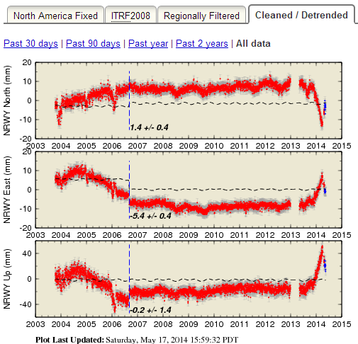
Here is a detrended graph of NRWY GPS station, updated on the 17th of May.
GPS source
Here is more information concerning the abrupt reversal of the inflation under the Norris Basin.
Ground deformation
The ground deformation occurring in north-central Yellowstone abruptly changed direction on about April 6, 2014, one week following a M4.8 earthquake in the same region. The change is most prominent on the NRWY GPS station (earthquake.usgs.gov...), but is also detectable on other nearby stations. Since April 6, 2014, NRWY has moved about 0.5 cm west, 1 cm north, and 2 cm down, reversing about 1/3 of the deformation accumulated over the previous 8 months. (Note that last month’s update erroneously reported that NRWY had moved 2 cm north since August 1, 2013. In fact it had moved 2 cm SOUTH).
Slow caldera uplift, which began in early 2014 after 4 years of subsidence, continues at about 2 cm/yr.
YVO monthly update
Here is a detrended graph of NRWY GPS station, updated on the 17th of May.

GPS source
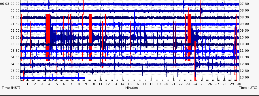
Yellowstone has been popping off small earthquakes in the NW corner of the park for the past 5 days. Another flurry of activity this morning, kicked
off by a Mag 3.5:
source
Here is the link to the Holmes Hill seismo, nearest to the activity.
This image of the Holmes Hill seismo is from the YVO monitoring page.
From the YVO monthly update, posted yesterday:
Concerning the ground deformation:
But....
Two centimeters in 5 months is... intriguing.
3.2 2014/06/03 03:52:52 44.780N 110.764W 9.1 29 km (18 mi) S of Gardiner, MT
1.9 2014/06/03 03:52:31 44.807N 110.748W -3.4 26 km (16 mi) S of Gardiner, MT
2.7 2014/06/03 03:39:25 44.788N 110.760W 8.6 28 km (17 mi) S of Gardiner, MT
3.5 2014/06/03 03:33:27 44.807N 110.760W 20.2 26 km (16 mi) S of Gardiner, MT
source
Here is the link to the Holmes Hill seismo, nearest to the activity.
This image of the Holmes Hill seismo is from the YVO monitoring page.

From the YVO monthly update, posted yesterday:
A north-south trending series of earthquakes, over seven miles in length, which began in September, 2013 picked up again from May 10 to 31 with 42 events. The largest earthquake was magnitude 3.5 on May 31, at 4:25 PM MDT, located about 13 miles southwest of Mammoth, Yellowstone National Park.
Earthquake sequences like these are common and account for roughly 50% of the total seismicity in the Yellowstone region.
Concerning the ground deformation:
Subsidence in north-central Yellowstone continues, although the deformation rate has slowed.
But....
Uplift within the Yellowstone Caldera, which began in 2014 after 4 years of subsidence, continues. Since the beginning of 2014, the caldera has risen about 2 cm.
Two centimeters in 5 months is... intriguing.
Any updates on ground deformation in the last few days, since the earthquakes?
a reply to: rigel434
The GPS haven't been updated yet today (it usually happens around 1500 UTC); I'll check later today. However, I wouldn't expect these quakes to have much influence on the inflation because they are occurring in the park, but outside the caldera, while the inflation is centered nearer the middle of the caldera.
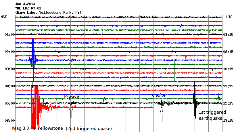
Looking at the seismograms, it appears that the s-waves from the mag 5.7 up near Haines, Alaska triggered 2 small quakes in Yellowstone, including this mag 3.3.
(From station Mary Lake.)
The GPS haven't been updated yet today (it usually happens around 1500 UTC); I'll check later today. However, I wouldn't expect these quakes to have much influence on the inflation because they are occurring in the park, but outside the caldera, while the inflation is centered nearer the middle of the caldera.
Looking at the seismograms, it appears that the s-waves from the mag 5.7 up near Haines, Alaska triggered 2 small quakes in Yellowstone, including this mag 3.3.

(From station Mary Lake.)
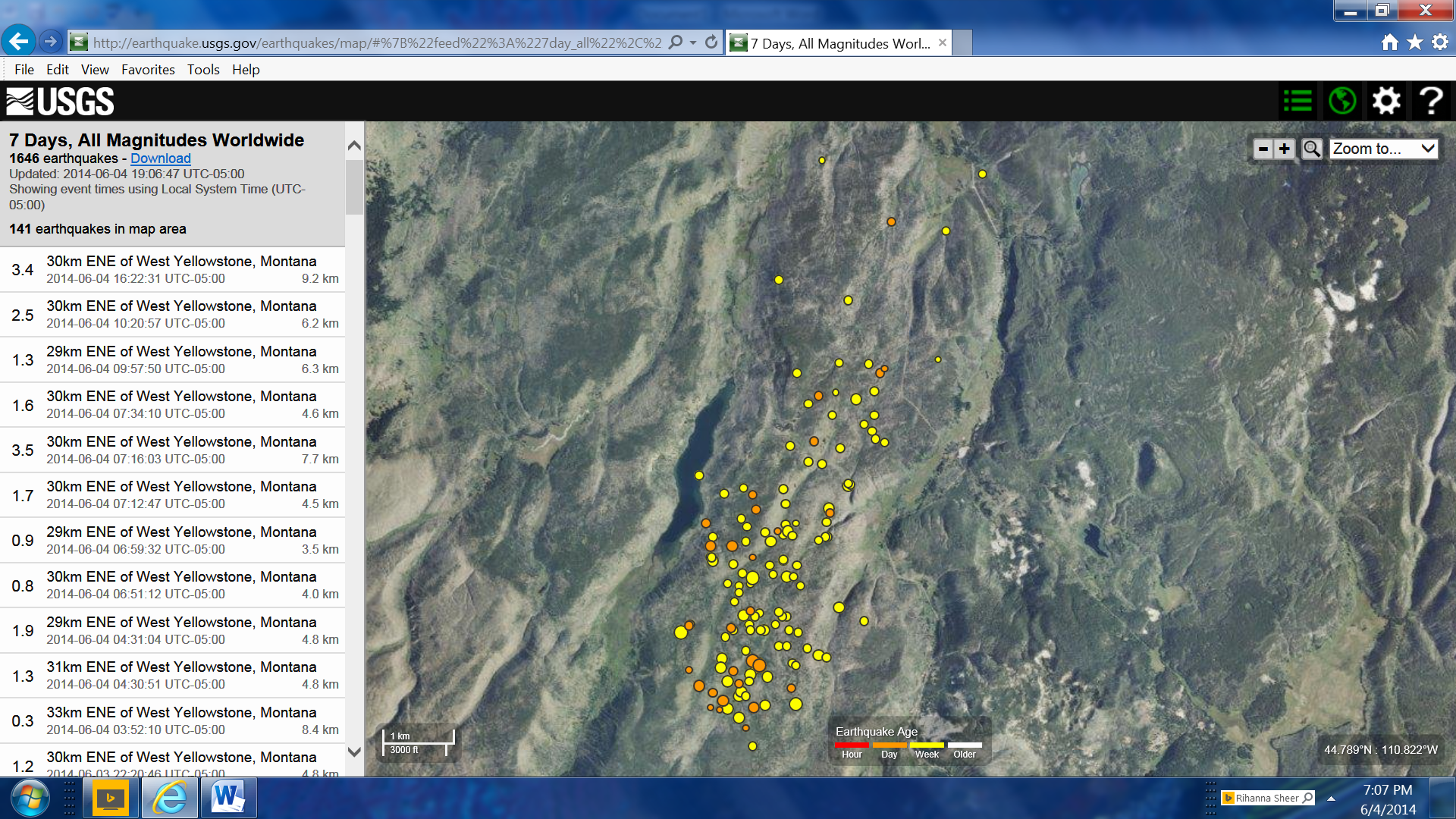
New One 3.4
141 Earthquakes in this area last 7 days
earthquake.usgs.gov... llite%22%2C%22autoUpdate%22%3Atrue%2C%22restrictListToMap%22%3Atrue%2C%22timeZone%22%3A%22local%22%2C%22mapposition%22%3A%5B%5B44.7751332217051%2C-110 .82441329956053%5D%2C%5B44.84528098810554%2C-110.65961837768554%5D%5D%2C%22overlays%22%3A%7B%22plates%22%3Atrue%7D%2C%22viewModes%22%3A%7B%22map%22%3A true%2C%22list%22%3Atrue%2C%22settings%22%3Afalse%2C%22help%22%3Afalse%7D%7D
141 Earthquakes in this area last 7 days

earthquake.usgs.gov... llite%22%2C%22autoUpdate%22%3Atrue%2C%22restrictListToMap%22%3Atrue%2C%22timeZone%22%3A%22local%22%2C%22mapposition%22%3A%5B%5B44.7751332217051%2C-110 .82441329956053%5D%2C%5B44.84528098810554%2C-110.65961837768554%5D%5D%2C%22overlays%22%3A%7B%22plates%22%3Atrue%7D%2C%22viewModes%22%3A%7B%22map%22%3A true%2C%22list%22%3Atrue%2C%22settings%22%3Afalse%2C%22help%22%3Afalse%7D%7D
i don't think i can link to it but someone on facebook shared a photo from yellowstone and said this:
"I was on a guided tour of Old Faithful, and I happened to see this geyser going off in the distance. Everybody turned to look at it; the guide said it was Castle Geyser and that was the first time he had seen it erupt"
he also said that the guides told him there were 10 quakes a day happening.... i'm not sure what that means. if he meant there are 10 significant ones (out of the ordinary) or they were just stating something that's fairly normal.
anyone know more about the Castle Geyser???? i'm curious if this is an unusual event or if he just misinterpreted the tour guide.
edit to add.... i should have just looked up the geyser before i posted. it erupts regularly. his guide made it seem like it was unusual.
edit on 11-6-2014 by pasiphae because: (no reason given)
Breaking! Yellowstone's Geysers Erupting! Just Released Videos!
June 6th, 2014
youtu.be...
New Geyser Data on Yellowstone! Not Great News?
June 12th, 2014
youtu.be...
ALERT: U.S. E.L.E. Coming? Entire U.S. Volcanic, Earthquakes Sites Being Shut Down
June 14th, 2014
youtu.be...
June 6th, 2014
youtu.be...
New Geyser Data on Yellowstone! Not Great News?
June 12th, 2014
youtu.be...
ALERT: U.S. E.L.E. Coming? Entire U.S. Volcanic, Earthquakes Sites Being Shut Down
June 14th, 2014
youtu.be...
edit on 6/17/2014 by Hx3_1963 because: (no reason given)
It's been really quiet at our favorite caldera over the past few weeks; only 10 earthquakes over the preceding 14 days and all very small.
Yesterday, the YVO released a press statement regarding the new data concerning the magma chamber revealed through seismic tomography, that was published a few months back.
Here is a diagram showing the new model of the crustal magma chamber, which is 2.5 times larger than originally thought.
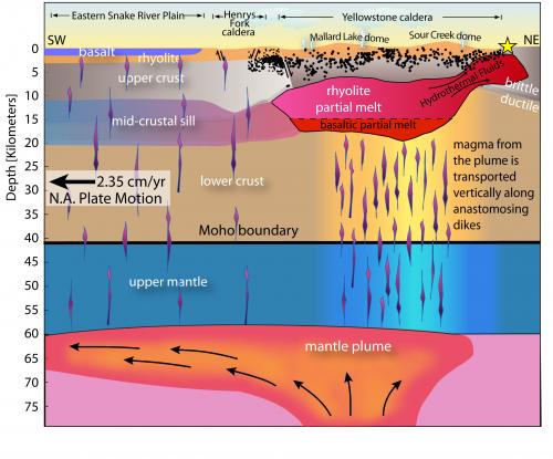
From the Yellowstone Volcano Observatory news:
It reads as if, to the volcanologists' best modeling, this beast is not on the cusp of erupting. Good news.
Yesterday, the YVO released a press statement regarding the new data concerning the magma chamber revealed through seismic tomography, that was published a few months back.
Here is a diagram showing the new model of the crustal magma chamber, which is 2.5 times larger than originally thought.

From the Yellowstone Volcano Observatory news:
Analysis of the data reveals that the magma reservoir contains between about 5 and 15% molten rock (melt) that occupies pore spaces between solid (crystalline) material. Magma typically does not erupt unless it has greater than 50% melt.
The larger imaged size of the magma reservoir better matches the geologic record of Late Quaternary volcanic eruptions and lava flows but, importantly, does not increase the volcanic hazard in the Yellowstone region.
It reads as if, to the volcanologists' best modeling, this beast is not on the cusp of erupting. Good news.
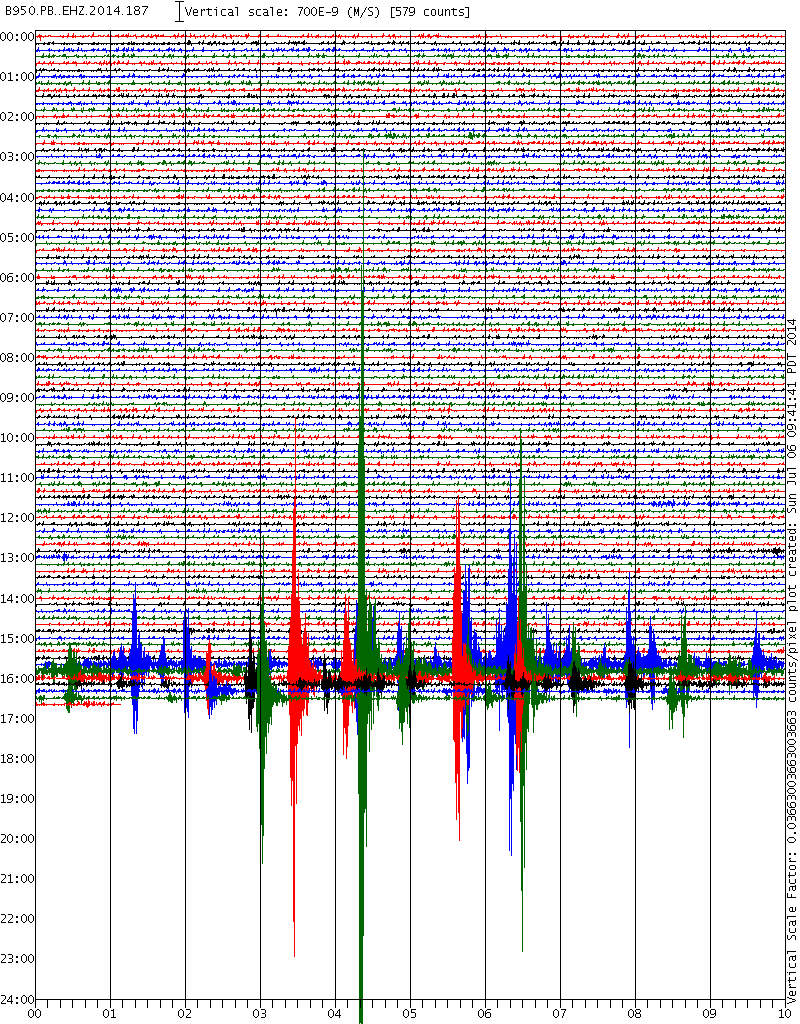
It looks like Yellowstone has burbled back from its quiet time. This seismogram is from north of Norris Basin, station PB.B950..EHZ.
 link
link
Small, but the lack of earthquakes in the park was becoming deafening. I just checked USGS. They have the largest quake as mag 1.9, NNE of Old Faithful.

Small, but the lack of earthquakes in the park was becoming deafening. I just checked USGS. They have the largest quake as mag 1.9, NNE of Old Faithful.
edit on 7/6/2014 by Olivine
because: add a link
RSOE EDIS Event Report - The ever-changing thermal geology of Yellowstone National Park has created a hot spot that melted an asphalt road and closed
access to popular geysers and other attractions at the height of tourist season, officials said Thursday. As they examined possible fixes, park
officials warned visitors not to hike into the affected area, where the danger of stepping through solid-looking soil into boiling-hot water was high.
"There are plenty of other great places to see thermal features in the park," Yellowstone spokesman Al Nash said. "I wouldn't risk personal injury
to see these during this ...
a reply to: pasiphae
How bout maybe they changed that data after the geyser started erupting. Maybe the guide is right, and it doesn't erupt often, but to continue the charade that nothing is amiss at Yellowstone, they change the info on that geyser to say that it does erupt often. Well, just suggesting other possibilities.
How bout maybe they changed that data after the geyser started erupting. Maybe the guide is right, and it doesn't erupt often, but to continue the charade that nothing is amiss at Yellowstone, they change the info on that geyser to say that it does erupt often. Well, just suggesting other possibilities.
a reply to: Rezlooper
The morning Geyser started erupting again in 2012 after 18 years of inactivity so perhaps just mixed up his geysers with another that has just started erupting.
www.yellowstonegate.com...
The morning Geyser started erupting again in 2012 after 18 years of inactivity so perhaps just mixed up his geysers with another that has just started erupting.
www.yellowstonegate.com...
a reply to: glend
YELLOWSTONE GIANTESS GEYSER
www.yellowstonepark.com...
YELLOWSTONE GIANTESS GEYSER
www.yellowstonepark.com...
North of the prolific Old Faithful, and across the Firehole River, sits the geyser know as Giantess. You’ve probably never heard of the Giantess because for the last 2 years and 139 days – until January 29, 2014 that is – the geyser was dormant. So imagine the National Park Service’s surprise when on the 29th this very large and very noisy geyser erupted and stayed active for over 40 hours.
edit on 12 7 2014 by glend because: (no reason given)
Odd... A few hours ago, I was looking at some strange anomalies from earlier today on the University of Utah webicorder displays.
Now when I go to check them out again, every webicorder display for today is blank.
Station Map
Now when I go to check them out again, every webicorder display for today is blank.
Station Map
new topics
-
Trump Presidential Transition Team will not use GSA or Government entities to come to DC
US Political Madness: 7 minutes ago -
Mind Blowing Cave under someones land
Fragile Earth: 28 minutes ago -
The Party of Peace - Trump Cabinet Picks Targeted with Death Threats
US Political Madness: 1 hours ago -
V.P. Kamala Harris releases a video and nobody understands why
US Political Madness: 4 hours ago -
D.B. Cooper mystery may be solved
General Conspiracies: 9 hours ago
top topics
-
D.B. Cooper mystery may be solved
General Conspiracies: 9 hours ago, 19 flags -
V.P. Kamala Harris releases a video and nobody understands why
US Political Madness: 4 hours ago, 14 flags -
The Party of Peace - Trump Cabinet Picks Targeted with Death Threats
US Political Madness: 1 hours ago, 6 flags -
Mind Blowing Cave under someones land
Fragile Earth: 28 minutes ago, 2 flags -
Trump Presidential Transition Team will not use GSA or Government entities to come to DC
US Political Madness: 7 minutes ago, 1 flags
active topics
-
Mind Blowing Cave under someones land
Fragile Earth • 4 • : ColeYounger2 -
V.P. Kamala Harris releases a video and nobody understands why
US Political Madness • 36 • : Dandandat3 -
Trump Presidential Transition Team will not use GSA or Government entities to come to DC
US Political Madness • 0 • : matafuchs -
I thought Trump was the existential threat?
World War Three • 101 • : cherokeetroy -
Ed Dowd some good news
Medical Issues & Conspiracies • 40 • : KrustyKrab -
The Party of Peace - Trump Cabinet Picks Targeted with Death Threats
US Political Madness • 4 • : nugget1 -
-@TH3WH17ERABB17- -Q- ---TIME TO SHOW THE WORLD--- -Part- --44--
Dissecting Disinformation • 3385 • : Thoughtful3 -
Well, here we go red lines crossed Biden gives the go ahead to use long range missiles
World War Three • 401 • : Xtrozero -
Interesting Video-UFO?
Aliens and UFOs • 19 • : Schmoe3755 -
Post A Funny (T&C Friendly) Pic Part IV: The LOL awakens!
General Chit Chat • 7835 • : underpass61
