It looks like you're using an Ad Blocker.
Please white-list or disable AboveTopSecret.com in your ad-blocking tool.
Thank you.
Some features of ATS will be disabled while you continue to use an ad-blocker.
share:

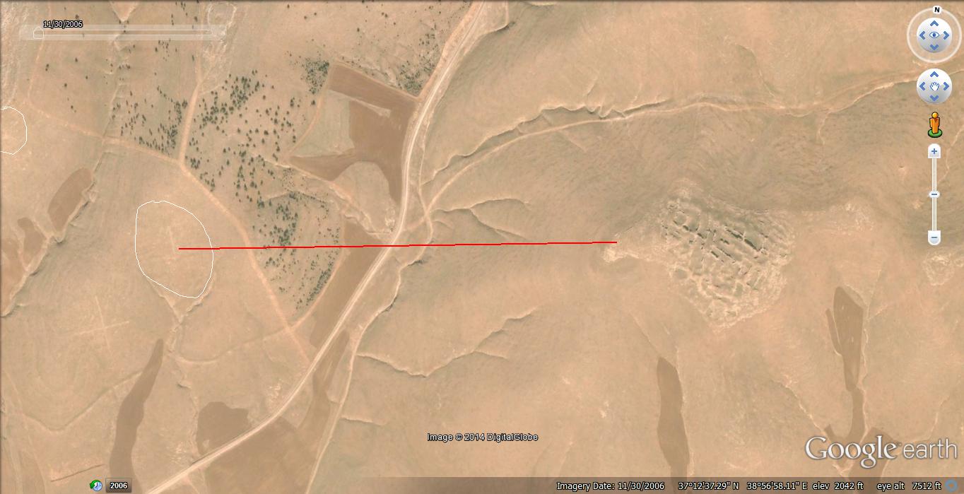
Ok, I'm hoping this gets flagged and the Google Earth junkies explain this, or at least name me as the source of this find. But, a few years ago I found some weird numbers on top of desert hills via Google Earth (Thumbnail above and Image Below). I have circled the numbers but you will need to enlarge the photograph to get a good look. The coordinates for the find are in the Google Earth image at the bottom right.
These numbers are huge, roughly 200 feet. They start southeast of Gobekli Temple and ascend towards the temple site. They are numbered 1 through 7 but the 6 is missing for some reason or I can't find it. They are best viewed in the older history images of Google Earth.
Please look at this carefully and tell me if you can figure out what the numbers are. This is pretty fascinating.
Please flag, tag and give your two cents worth.

Weird, i havent a clue.
Between the 4, 5 and 7 in the center of the triangle they form there could be a 6 or a 9. its ever so faint.
Between the 4, 5 and 7 in the center of the triangle they form there could be a 6 or a 9. its ever so faint.
I know next to nothing about the Turkish economy, so forgive me if this is a dumb question. Anyone know if there are any mining operations in that
area? As in, is this area rich in something that people could have conducted surveys in, maybe marking spots for future purposes?
Second stupid question. Could these be archaeological-originating markers for future excavation sites, numbers being used as references in aerial photos maybe?
Second stupid question. Could these be archaeological-originating markers for future excavation sites, numbers being used as references in aerial photos maybe?
I don't think they used numbers back then.
Have to see it my self to judge, be right back.
Edit: There are actually more markers in the whole area like X And a very faint O, but looks like it's of newer origin.
They are propably surveying the whole area and marked them by numbers, to be spoted from the air or something.
Have to see it my self to judge, be right back.
Edit: There are actually more markers in the whole area like X And a very faint O, but looks like it's of newer origin.
They are propably surveying the whole area and marked them by numbers, to be spoted from the air or something.
edit on 26-1-2014 by Mianeye
because: (no reason given)
edit on 26-1-2014 by Mianeye because: (no reason given)
edit on 26-1-2014 by Mianeye
because: (no reason given)
It is pretty interesting that although there many elevation changes in the terrain, the numbers are still in near perfect formation with no bends in
the straight lines.
Is that normal? I can't think of another known example with the same properties.
I won't claim to know, but my first guess was that the numbers were drawn on the photo and not originally on the earth.
Is that normal? I can't think of another known example with the same properties.
I won't claim to know, but my first guess was that the numbers were drawn on the photo and not originally on the earth.
Nyiah
I know next to nothing about the Turkish economy, so forgive me if this is a dumb question. Anyone know if there are any mining operations in that area? As in, is this area rich in something that people could have conducted surveys in, maybe marking spots for future purposes?
Second stupid question. Could these be archaeological-originating markers for future excavation sites, numbers being used as references in aerial photos maybe?
I thought of that too but wouldn't the markers be a little more vibrant? Plus the time it would take. Couldn't they just drop an electronic beacon more easily?
reply to post by Longshots
For anyone interested the co-ordinates are 37.223237° N, 38.922546° E for the temple.
There are symbols mixed in with numbers if you look closely.
If they are ancient i don't know what it's for. If they are modern, it's probably for calibration purposes.
For anyone interested the co-ordinates are 37.223237° N, 38.922546° E for the temple.
There are symbols mixed in with numbers if you look closely.
If they are ancient i don't know what it's for. If they are modern, it's probably for calibration purposes.
If the temple was abandon in 8 millennia BCE.. and the numbers are more modern. I would say they're not related as far as ancients putting them there.
But possible markers for archaeologist Aerial mapping via plane perhaps. The missing 6 may be Gobekli Tepe. Don't know. Good find.
www.andrewcollins.com...
If the link works
www.andrewcollins.com...
If the link works
edit on 26-1-2014 by Bigburgh because: (no reason given)
edit on 26-1-2014 by Bigburgh because: (no reason given)
reply to post by Longshots
I sugget its for surveying purposes. Archaeologists have radar penetrated 22 acres in the area for future research.
I sugget its for surveying purposes. Archaeologists have radar penetrated 22 acres in the area for future research.
he explains that he has mapped the entire summit using ground-penetrating radar and geomagnetic surveys, charting where at least 16 other megalith rings remain buried across 22 acres. The one-acre excavation covers less than 5 percent of the site. He says archaeologists could dig here for another 50 years and barely scratch the surface.
Read more: www.smithsonianmag.com...
Give the gift of Smithsonian magazine for only $12!: http://(link tracking not allowed)/1cGUiGv
interesting. S+F for the curious find.
it appears there could also be an 8 to the left of the 7, though its format doesnt fit with the other numbers...
if you look at it and picture the valleys filled with water, then the sites marked would be ideal locations for settlements of some kind, or temples, etc. they are on the apex of what would be each bay or inlet. with the exception of #1
as an above poster stated, they could be marked for future excavation purposes? though I can hardly think why they would be so large? unless im seeing the scale incorrectly
reply to post by Longshots
Interesting find. I have seen numbers and makings like this used to train military helicopter pilots, but this is really just speculation. They are quite crude markings, could also be archaeological or grid mapping tools. The peak between 5 and 7 to the west seems to have an arrow on it. Could just be my eyes playing tricks on me.
AX
FTNWO
They're Arabic numerals as used in the West, and clearly modern. Someone above mentioned possible related to mining, but could also be related to
military flight training. We've seen images like these before of numbers and strange symbols in the desert that were from military bomb ranges.
Hopefully nothing like that would be conducted close to an archeological site.
reply to post by Longshots
Wow, there actually are numbers there - I'm impressed - I couldn't see them from the thumbnail, but checked out the larger picture as you recommended. It was pretty cool to have something like this where I was like "Wow, I'm not contesting the O.P. at all here."
I also think they might be used for aerial surveying of some kind - perhaps for archaeological radar penetration? That's my vote, at least.
edit on 27amMon, 27 Jan 2014 04:02:04 -0600kbamkAmerica/Chicago by darkbake because: (no reason given)
The modern numeral system which is called the Arabic Numeral System which is derived from the Indian/"Hindu" Numeral System did not exist at any
time during the creation or existence or in the near periods of Gobekli Tepe which is said to have been constructed/existed from 7560 - 9400 BCE.
The Indian / Hindu Numeric System were developed only in the 3rd or 4th century BC.
Either these could be modern constructs or a case of paraeilodia.
The Indian / Hindu Numeric System were developed only in the 3rd or 4th century BC.
Either these could be modern constructs or a case of paraeilodia.
200 foot numbers!? Would indicate they are meant to be seen from helicopters for navigation purposes.
Finally some construction from over 10,000 yrs ago
SnF
Finally some construction from over 10,000 yrs ago
SnF
Might date back to WW1...the Turkish invasion was back in 1915, these numbers might have been to aid area identification like which hill was which.
Or could be modern.
There's also an interesting number 2, to the right of the 7. It looks raised, unlike the others which look more like scrapes in the ground.
Or could be modern.
There's also an interesting number 2, to the right of the 7. It looks raised, unlike the others which look more like scrapes in the ground.
edit on 27-1-2014 by MysterX because: (no reason given)
new topics
-
Federal law trumps state and local law every time
Social Issues and Civil Unrest: 6 hours ago
top topics
-
Federal law trumps state and local law every time
Social Issues and Civil Unrest: 6 hours ago, 14 flags
active topics
-
Comcast dumping MSNBC
Mainstream News • 34 • : xuenchen -
Interesting Video-UFO?
Aliens and UFOs • 15 • : devilhunter69 -
DOJ Special Counsel Robert HUR Says JOE BIDEN Can Be ARRESTED After Jan 20th 2025.
Above Politics • 24 • : WeMustCare -
International Criminal Court Issues Arrest Warrant For Netanyahu
Mainstream News • 53 • : WeMustCare -
President-Elect DONALD TRUMP's 2nd-Term Administration Takes Shape.
Political Ideology • 252 • : WeMustCare -
The Reactionary Conspiracy 13. The plot’s theology.
General Conspiracies • 314 • : Oldcarpy2 -
Post A Funny (T&C Friendly) Pic Part IV: The LOL awakens!
General Chit Chat • 7830 • : KrustyKrab -
Well, here we go red lines crossed Biden gives the go ahead to use long range missiles
World War Three • 374 • : annonentity -
Anyone like the Scorpions?
Music • 20 • : BasicResearchMethods -
Federal law trumps state and local law every time
Social Issues and Civil Unrest • 17 • : fringeofthefringe

