It looks like you're using an Ad Blocker.
Please white-list or disable AboveTopSecret.com in your ad-blocking tool.
Thank you.
Some features of ATS will be disabled while you continue to use an ad-blocker.
share:
a reply to: ArMaP
So what's all this talk about Mt. Sharpe being made of sediment from the lake, and that when the Rover nears it, and climbs the foothills a little bit, it will be moving through eons of sedimentary layers. Is that all wrong, and this little tiny lake is all there was? A rubber ducky wouldn't even have enough room to float around.
So what's all this talk about Mt. Sharpe being made of sediment from the lake, and that when the Rover nears it, and climbs the foothills a little bit, it will be moving through eons of sedimentary layers. Is that all wrong, and this little tiny lake is all there was? A rubber ducky wouldn't even have enough room to float around.
originally posted by: Aleister
So what's all this talk about Mt. Sharpe being made of sediment from the lake, and that when the Rover nears it, and climbs the foothills a little bit, it will be moving through eons of sedimentary layers. Is that all wrong, and this little tiny lake is all there was?
Didn't you see what ionwind posted?
Some people think mount Sharp was created by wind moving the sediments, with no water needed, but I don't agree with that theory of it being some kind of huge solidified dune.
Time will tell.
originally posted by: ArMaP
The problems I see is that Curiosity landed on the area marked in blue (I think), so we don't have data for the rest of the bottom of the crater, and the wind erosion on the bottom of a larger lake would make it different from the bottom of the more recent, smaller lake.
You are right, we only have very good data for where Curiosity and to some degree HiRISE have been or seen.
There is an alluvial fan in the north of the crater, which indicates the direction the water flowed in at some point. If it had been underwater, there would be no fan. Maybe the fan formed at a later time as the lake started to dry up.
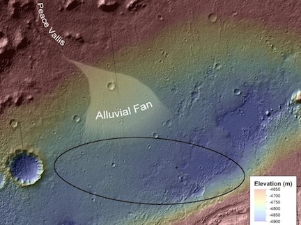
Link
Curiosity did land in the the blue area, and this area has had past water confirmed. Here's a route map:
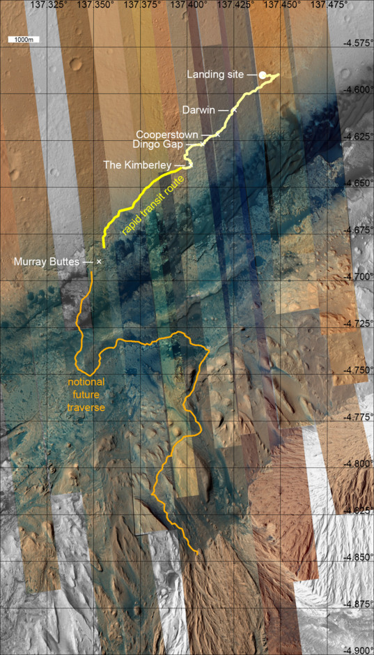
High Resolution
The planned future path, in orange, shows the route the rover could take. Once we start climbing Mount Sharp, not only will the images will be stunning, but who knows what we will find. It will be like nothing we've seen before
a reply to: ionwind
Great post, thanks. I haven't kept track of the route, how close is Curiosity to the Buttes (and has it even left Kimberly as yet?). I've been doing other things this past month or so, and haven't focused on the mission as much as earlier in the year. And good to meet you, nice work.
Great post, thanks. I haven't kept track of the route, how close is Curiosity to the Buttes (and has it even left Kimberly as yet?). I've been doing other things this past month or so, and haven't focused on the mission as much as earlier in the year. And good to meet you, nice work.
originally posted by: Aleister
a reply to: ionwind
Great post, thanks. I haven't kept track of the route, how close is Curiosity to the Buttes (and has it even left Kimberly as yet?). I've been doing other things this past month or so, and haven't focused on the mission as much as earlier in the year. And good to meet you, nice work.
Likewise. Right now Curiosity has left Kimberly and would be in the yellow "rapid transit route" phase from my previous post. They How long it will take to get to the Murray Buttes depends on how much science they do along the way. They may stop if they find something interesting.
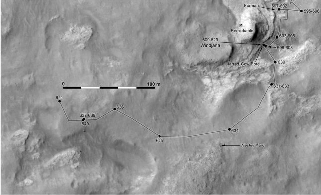
Starting to climb Mount Sharp will definitely be awesome.
You can keep track of where Curiosity is by checking out this route thread, which is updated frequently:
MSL Route Map
edit on 28-5-2014 by ionwind because: (no reason given)
originally posted by: symptomoftheuniverse
Theres a stright line at the botom of the diamond shaped metal block. We need to see it from all sides.
What do you mean by "diamond shaped metal block"?

a reply to: ArMaP
Does the metal at the top look diamond shaped?
mars.jpl.nasa.gov...
Does the metal at the top look diamond shaped?
mars.jpl.nasa.gov...
edit on 29-5-2014 by symptomoftheuniverse because: (no reason given)
originally posted by: ionwind
originally posted by: ArMaP
The problems I see is that Curiosity landed on the area marked in blue (I think), so we don't have data for the rest of the bottom of the crater, and the wind erosion on the bottom of a larger lake would make it different from the bottom of the more recent, smaller lake.
You are right, we only have very good data for where Curiosity and to some degree HiRISE have been or seen.
There is an alluvial fan in the north of the crater, which indicates the direction the water flowed in at some point. If it had been underwater, there would be no fan. Maybe the fan formed at a later time as the lake started to dry up.
Link
Curiosity did land in the the blue area, and this area has had past water confirmed. Here's a route map:
High Resolution
The planned future path, in orange, shows the route the rover could take. Once we start climbing Mount Sharp, not only will the images will be stunning, but who knows what we will find. It will be like nothing we've seen before
THANKS For this update
Interesting days ahead!
a reply to: symptomoftheuniverse
it looks a bit rhombus shaped.
a piece looks like it laying on the surface thoughand isn't partially buried like the other pieces
odd
funbox
it looks a bit rhombus shaped.
a piece looks like it laying on the surface thoughand isn't partially buried like the other pieces
odd
funbox
originally posted by: Blue Shift
originally posted by: Aleister
Thanks. I like that they call it the "Rapid transit" route. Gives hope that it will be a 'rapid transit'.
Sure. That way they can just zoom right past other things that might be even more interesting.
I'm thinking of the (hopefully) slight chance that the wheels give way, or something breaks, or the computer is hit by flying debris of monsterous origin, or.... that at least the Rover will get to the Buttes and beyond while working and in one piece.
a reply to: ionwind
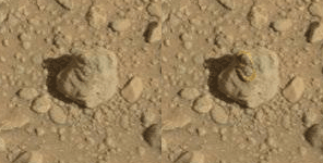
Here goes another close-up of the "meteorite" in all its glory, stitched together from two MastCam100 images taken on sol 640:
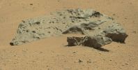
Source Images 01 | 02
Some of the features are quite similar to the Willamette Meteorite which is the largest iron-nickel meteorite found in North America up to this day.
Here goes another close-up of the "meteorite" in all its glory, stitched together from two MastCam100 images taken on sol 640:

Source Images 01 | 02
Some of the features are quite similar to the Willamette Meteorite which is the largest iron-nickel meteorite found in North America up to this day.
edit on 30-5-2014 by jeep3r because: text
in england we say diamond/kite/rhombus/ shape , the meteorite seems in at least 3 pieces and some seems buried in the sand. That all area could be meteorite,who forgot to put a shovel on curio?
originally posted by: funbox
a reply to: symptomoftheuniverse
it looks a bit rhombus shaped.
a piece looks like it laying on the surface thoughand isn't partially buried like the other pieces
odd
funbox
Then theres the glowing bit near the"mineral veins" between the large lump and the rombus lump.
Fossilized planaria:
mars.jpl.nasa.gov...

mars.jpl.nasa.gov...
edit on 31-5-2014 by Blue Shift because: (no reason given)
originally posted by: Blue Shift
Fossilized planaria:
mars.jpl.nasa.gov...
That certainly is a quite interesting segmented object. Lots of regular segments arranged in what seems to be a biological pattern. Nice find, and one which should have more eyes (and ears, if you've got 'em) on it.
new topics
-
Short vs. Long?
General Chit Chat: 2 hours ago -
Outgoing Lame Duck BIDEN Officials and Democrats Voice Their Regrets.
2024 Elections: 7 hours ago -
Reflections of Elections past
US Political Madness: 9 hours ago -
President Carter has passed
Mainstream News: 11 hours ago -
Get Reday - Here comes the Bird Flu Pandemic - Millions are Notified
Diseases and Pandemics: 11 hours ago
top topics
-
Get Reday - Here comes the Bird Flu Pandemic - Millions are Notified
Diseases and Pandemics: 11 hours ago, 17 flags -
President Carter has passed
Mainstream News: 11 hours ago, 16 flags -
Outgoing Lame Duck BIDEN Officials and Democrats Voice Their Regrets.
2024 Elections: 7 hours ago, 7 flags -
2 Guys die hunting Bigfoot
Cryptozoology: 12 hours ago, 6 flags -
Reflections of Elections past
US Political Madness: 9 hours ago, 5 flags -
Joe Rogan and The Black Keys Diorama
General Entertainment: 14 hours ago, 3 flags -
Short vs. Long?
General Chit Chat: 2 hours ago, 1 flags
active topics
-
Get Reday - Here comes the Bird Flu Pandemic - Millions are Notified
Diseases and Pandemics • 23 • : BeyondKnowledge3 -
Short vs. Long?
General Chit Chat • 2 • : BeyondKnowledge3 -
My personal experiences and understanding of orbs
Aliens and UFOs • 35 • : Compendium -
Why Such An Uproar Over Non-US Citizens With H1-B Work Visas.
Social Issues and Civil Unrest • 81 • : WeMustCare -
President Carter has passed
Mainstream News • 13 • : WeMustCare -
Joe Rogan and The Black Keys Diorama
General Entertainment • 6 • : GENERAL EYES -
Outgoing Lame Duck BIDEN Officials and Democrats Voice Their Regrets.
2024 Elections • 6 • : WeMustCare -
Treasury Secretary Janet Yellen Says The USA Will Be in Debt Default in Jan 2025 - Unless...
Mainstream News • 35 • : cherokeetroy -
-@TH3WH17ERABB17- -Q- ---TIME TO SHOW THE WORLD--- -Part- --44--
Dissecting Disinformation • 3846 • : 777Vader -
This is why ALL illegals who live in the US must go
Social Issues and Civil Unrest • 35 • : charlyv
