It looks like you're using an Ad Blocker.
Please white-list or disable AboveTopSecret.com in your ad-blocking tool.
Thank you.
Some features of ATS will be disabled while you continue to use an ad-blocker.
share:
Tell me if I am crazy?
M 1.4 - 4km SE of El Cerrito, California
Time
2014-05-02 12:34:07 UTC-05:00
Location
33.816°N 117.490°W
Depth
3.5km
Location on map is down below Corona in No Cal.
El Cerrito is in the Bay Area.
Someone not paying attention?
Just thought it was odd.
M 1.4 - 4km SE of El Cerrito, California
Time
2014-05-02 12:34:07 UTC-05:00
Location
33.816°N 117.490°W
Depth
3.5km
Location on map is down below Corona in No Cal.
El Cerrito is in the Bay Area.
Someone not paying attention?
Just thought it was odd.
a reply to: berkeleygal
There is a community in the area south of Corona known as El Cerrito
There is a community in the area south of Corona known as El Cerrito
edit on 5/2/2014 by abecedarian because: (no reason given)
Hmm, up around Noatak, AK is getting a little active. Looking at the main & largest aftershock, I wonder if this is going to toss out something even
bigger?
USGS
4.3 25km ENE of Noatak, Alaska 2014-05-03 18:48:07 UTC 10.0 km
3.6 5km E of Noatak, Alaska 2014-05-03 17:15:27 UTC 10.0 km
4.0 22km NE of Noatak, Alaska 2014-05-03 12:29:11 UTC 10.0 km
4.2 27km NE of Noatak, Alaska 2014-05-03 11:54:33 UTC 10.0 km
4.3 34km ENE of Noatak, Alaska 2014-05-03 11:19:09 UTC 9.1 km
4.1 25km ENE of Noatak, Alaska 2014-05-03 10:40:53 UTC 10.0 km
3.6 27km ENE of Noatak, Alaska 2014-05-03 10:15:31 UTC 10.0 km
4.3 26km ENE of Noatak, Alaska 2014-05-03 10:09:45 UTC 10.0 km
4.7 21km NE of Noatak, Alaska 2014-05-03 09:57:08 UTC 10.0 km
4.7 43km NE of Noatak, Alaska 2014-05-03 09:51:07 UTC 20.6 km
4.2 19km NE of Noatak, Alaska 2014-05-03 09:47:48 UTC 10.0 km
3.3 31km ENE of Noatak, Alaska 2014-05-03 09:21:34 UTC 10.0 km
5.5 33km NE of Noatak, Alaska 2014-05-03 08:57:12 UTC 0.9 km
USGS
a reply to: Olivine
and
a reply to: BO XIAN
Not to take away from what Olivine was saying, but to expand further (link is on that page actually) what is happening Lower North Island, NZ, seems to be the slow-slip events may be compensating for the lack of mega-thrust quakes in this area. Each article contradicts the other. one says the plate boundary is locked, the other says its slow slipping.
If it keeps slow slipping then the risks of a big mega-thrust quake diminish. That's how I read it anyway.
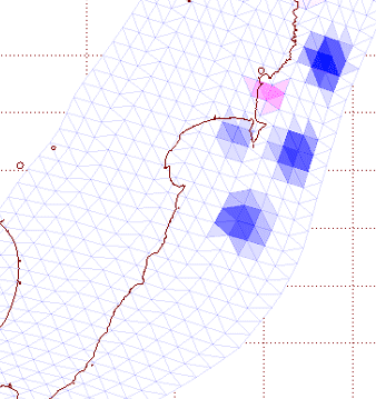
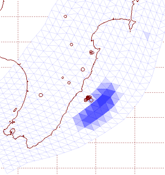
There is a good animation on the page I'm talking about, shows the slow-slip areas 2009-2012. 2010 and 2011 had more of them.
Couple of screenshots


That page also has a similar map to the one Olivine posted, showing the stuck area, but with the slow-slip areas added, however the animation contradicts this, (see 2nd image above with blue areas off Cape Turnagain)
and
a reply to: BO XIAN
Not to take away from what Olivine was saying, but to expand further (link is on that page actually) what is happening Lower North Island, NZ, seems to be the slow-slip events may be compensating for the lack of mega-thrust quakes in this area. Each article contradicts the other. one says the plate boundary is locked, the other says its slow slipping.
If it keeps slow slipping then the risks of a big mega-thrust quake diminish. That's how I read it anyway.
There is a good animation on the page I'm talking about, shows the slow-slip areas 2009-2012. 2010 and 2011 had more of them.
Couple of screenshots


That page also has a similar map to the one Olivine posted, showing the stuck area, but with the slow-slip areas added, however the animation contradicts this, (see 2nd image above with blue areas off Cape Turnagain)
I'm back from Taranaki for the weekend, back to earthquakes country..........
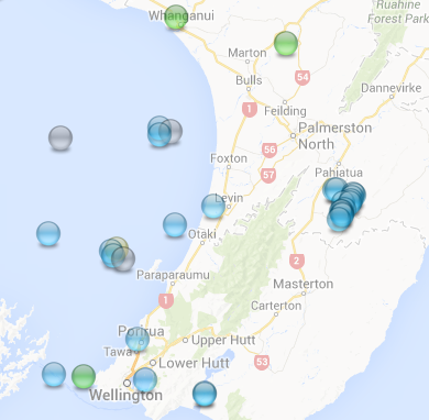
Just Heard and Felt this one, close by, big boom and shaking for 10 seconds.
may go up in magnitude a few more decimal points.
noticed there were a few more moderate intensity quakes (high 3's) across the country in the last 24 hrs
Sunday, May 4 2014 at 11:47:13 am NZST, M3.7, off Himatangi Beach, Foxton area
Sunday, May 4 2014 at 7:39:01 am NZST, M3.3, Rolleston, Canterbury
Just Heard and Felt this one, close by, big boom and shaking for 10 seconds.
may go up in magnitude a few more decimal points.
Public ID 2014p332793
Universal Time May 4 2014 at 3:12:47
NZ Standard Time Sunday, May 4 2014 at 3:12:47 pm
Latitude, Longitude -40.85, 174.82
Intensity ? light
Focal Depth 71 km
Magnitude 4.4
Location 15 km west of Paraparaumu
www.geonet.org.nz...
noticed there were a few more moderate intensity quakes (high 3's) across the country in the last 24 hrs
Sunday, May 4 2014 at 11:47:13 am NZST, M3.7, off Himatangi Beach, Foxton area
Sunday, May 4 2014 at 7:39:01 am NZST, M3.3, Rolleston, Canterbury
edit on 05u12212214 by muzzy because: (no reason given)
Two big ones just south of the Fiji islands.
Magnitude Mi 6.8
Region SOUTH OF FIJI ISLANDS
Date time 2014-05-04 09:15:52.0 UTC
Location 24.65 S ; 179.21 E
Depth 531 km
Distances 693 km SW of Nuku‘alofa, Tonga / pop: 22,400 / local time: 22:15:52.0 2014-05-04
725 km S of Suva, Fiji / pop: 77,366 / local time: 21:15:52.0 2014-05-04
1329 km E of Nouméa, New Caledonia / pop: 93,060 / local time: 20:15:52.0 2014-05-04
Followed closely by
Magnitude mb 6.1
Region SOUTH OF FIJI ISLANDS
Date time 2014-05-04 09:25:15.0 UTC
Location 25.86 S ; 178.22 E
Depth 615 km
Distances 852 km SW of Nuku‘alofa, Tonga / pop: 22,400 / local time: 22:25:15.0 2014-05-04
855 km S of Suva, Fiji / pop: 77,366 / local time: 21:25:15.0 2014-05-04
1260 km E of Nouméa, New Caledonia / pop: 93,060 / local time: 20:25:15.0 2014-05-04
a reply to: Anneke
Interesting conversion on Geofon, 1 decimal point in mb converts to 2 -3 decimal points in Mw, 101km difference in depth between the two quakes
09:15:52.6 UTC, 6.2mb, 6.5Mw, 516km
09:25:15.1 UTC, 6.1mb, 6.3Mw, 615km
6.1mb = 21,301.409 TTNT / 6.3Mw = 42,501.898 TTNT, 99.5% difference (2 decimal points)
6.2mb = 30,089.039 TTNT / 6.5Mw = 84,802.435 TTNT, 182% difference (3 decimal points)
comparing quake with quake;
6.2mb-6.1mb = 8,787.631 TTNT, 41% more energy released
6.5Mw-6.3Mw = 42,300.537 TTNT, 99.5% more energy released
I'll never understand how they work that out!
edit on 05u12312314 by muzzy because: (no reason given)
Occurred at (JST) 05:18 JST 05 May 2014
Latitude 35.0N
Longitude 139.4E
Depth 160 km
Magnitude 6.2 ML
Region Name Izu-ohshima Kinkai
www.jma.go.jp...
originally posted by: muzzy
Occurred at (JST) 05:18 JST 05 May 2014
Latitude 35.0N
Longitude 139.4E
Depth 160 km
Magnitude 6.2 ML
Region Name Izu-ohshima Kinkai
www.jma.go.jp...
This one got me a little curious, it is the biggest one there since a long long time.
I hope this does not mean too much towards the fault lines at Fujisan.
edit on 5-5-2014 by aLLeKs because: (no reason given)
a reply to: berkeleygal
Probably, but it is just the USGS insistence on using these stupid locations instead of something simple and recognisable. Inside the US, because that is all one region in FE, it would probably be better to use Counties or whatever your local administrative area is, qualfied by the state in case of duplicated county names. Makes much more sense to me.
If the 'locals' can't fathom out these locations why in hell are USGS using them??????? Dumb I say.
While I am here, just testing something
2014-05-05 11:08:43, 19.702, 99.682, 6.0, 7.3 Thailand (733)
Did I miss someone posting that ?? (Apologies if I did but that was purely a test of the code for the line regardless of the quake.)
No - don't see it so here is the full text
Location in Google Maps
Derived from Event Data Source: USGS
Powered by QVSData
Probably, but it is just the USGS insistence on using these stupid locations instead of something simple and recognisable. Inside the US, because that is all one region in FE, it would probably be better to use Counties or whatever your local administrative area is, qualfied by the state in case of duplicated county names. Makes much more sense to me.
If the 'locals' can't fathom out these locations why in hell are USGS using them??????? Dumb I say.
While I am here, just testing something
2014-05-05 11:08:43, 19.702, 99.682, 6.0, 7.3 Thailand (733)
Did I miss someone posting that ?? (Apologies if I did but that was purely a test of the code for the line regardless of the quake.)
No - don't see it so here is the full text
Magnitude 6.0 - Thailand (733) [F]
Location in Google Maps
- Date-Time: Monday, May 05, 2014 @ 11:08:43 UTC
- Earthquake location: 19.703°N, 99.683°E,
- Earthquake depth: 7.4 km
- Distances:
9km (5mi) S of Mae Lao, Thailand
27km (16mi) SW of Chiang Rai, Thailand
39km (24mi) NW of Pa Daet, Thailand
52km (32mi) SSW of Mae Chan, Thailand
362km (224mi) WNW of Vientiane, Laos
- Event ID: usb000qack
Derived from Event Data Source: USGS
Powered by QVSData
edit on 5/5/2014 by PuterMan because: (no reason given)
originally posted by: muzzy
a reply to: Anneke
Interesting conversion on Geofon, 1 decimal point in mb converts to 2 -3 decimal points in Mw, 101km difference in depth between the two quakes
I only see one decimal point on GFZ for the Mw value (which I believe is not using the same calculation by the way). The conversion from 6.1 mb to Mw gives ~6.28 so the value is rounded as the full conversion is 6.28343, but the mb value is rounded as well so just how much 'error' creeps in?
6.2 mb converts to 6.36 Mw (or 6.36156) which would round to 6.4 NOT 6.5 (which is why I think these are separate calcs)
I'll never understand how they work that out!
It is just the same as the 'difference'
Taking the 6.1mb:
6.1mb = 21,301.409 TTNT / 6.3Mw = 42,501.898 TTNT,
The 6.3 is 21,200.49 TTNT greater than the 6.1. That value is nearly twice (because as we know 0.2 mb or Mw represents a quake that is twice as strong)
21,200.49 * 100 / 21,301.409 = 99.52622852 (rounded to your 99.5% difference)
comparing quake with quake;
6.2mb-6.1mb = 8,787.631 TTNT, 41% more energy released
6.5Mw-6.3Mw = 42,300.537 TTNT, 99.5% more energy released
The same is applied to this
If however you use the straight conversion then the second quake is 6.36 not 6.5 thus the calculation becomes (in round figures)
6.4Mw-6.3Mw = 60,035.53 - 42,501.90 = 17.533.63 = 41.25375571% which rounded is 41% just as you have for the first one.
This actually proves that the Mw calculations are not the same
someone may have posted this but i thought this was kinda nuts "rare earthquake warning for oklahoma". a 5.0 is expected within the next
month:
news.yahoo.com...
news.yahoo.com...
a reply to: pasiphae
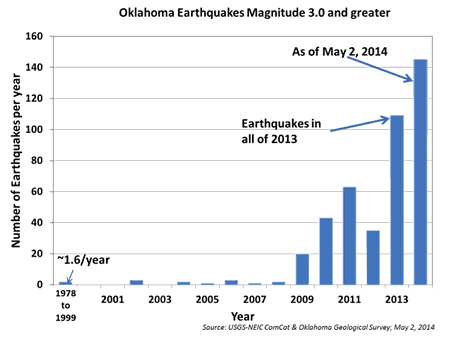
It's rare that USGS gives a warning. This graphic shows the uptick in Oklahoma earthquakes that has caused concern.

USGS news release
Whether all of these quakes are related to wastewater-injection or not, is still unknown; but to go from averaging only 2 magnitude 3.0 or higher quakes a year to over 140 in 5 months...something is brewing under the OK soil.
It's rare that USGS gives a warning. This graphic shows the uptick in Oklahoma earthquakes that has caused concern.

USGS news release
Whether all of these quakes are related to wastewater-injection or not, is still unknown; but to go from averaging only 2 magnitude 3.0 or higher quakes a year to over 140 in 5 months...something is brewing under the OK soil.
originally posted by: Darkblade71
posted on Apr, 13 2014 @ 03:43 PM
M3.7 - 11km SSW of Guthrie, Oklahoma 2014-04-13 20:02:21 UTC
USGS
I drove through Oklahoma about 3 years ago and got so creeped out going through Oklahoma City because I kept thinking about a big earthquake there. My brother told me to shut up because we were right in the middle of the city on the freeway, bad place for a big EQ. So my question is to the EQ experts...
All of these earthquakes there, is no one worried about a major earthquake?
What is the biggest in that area?
Why is the ground shaking so much in this area?
Is it really frakking?
I just don't buy that.
The EQ warning for Ok does not surprise me one bit.
I have no doubt it is going to get seriously rocked.
No posts in 26 hours since my last one???
Is everyone on sabbatical?
Is everyone on sabbatical?
originally posted by: radpetey
A couple quakes today at the south end of the nasty beast!!
earthquake.usgs.gov...
I did not realize that the USGS link I posted was a real time pic of recent quakes.
I figured it would freeze the page I cut and pasted.
The two quakes I was referring to were on the south end of Cascadia, in what I think is the part of the fault that is most locked
new topics
-
Watching TV
Jokes, Puns, & Pranks: 6 minutes ago -
RFK is Trumps health pick
2024 Elections: 8 hours ago
top topics
-
The art of being offended
Social Issues and Civil Unrest: 16 hours ago, 20 flags -
FLORIDA Sues Biden-Harris FEMA for Denying Disaster Assistance to Homeowners with TRUMP Signs.
US Political Madness: 17 hours ago, 15 flags -
Thanksgiving 2024
Member Art: 14 hours ago, 13 flags -
RFK is Trumps health pick
2024 Elections: 8 hours ago, 12 flags -
Watching TV
Jokes, Puns, & Pranks: 6 minutes ago, 0 flags
active topics
-
The art of being offended
Social Issues and Civil Unrest • 34 • : Dandandat3 -
Mike Tyson returns 11-15-24
World Sports • 32 • : Encia22 -
President-elect TRUMP Picks MATT GAETZ for his ATTORNEY GENERAL - High Level PANIC Ensues.
2024 Elections • 73 • : marg6043 -
Watching TV
Jokes, Puns, & Pranks • 0 • : DAVID64 -
Thanksgiving 2024
Member Art • 17 • : Flyingclaydisk -
Judge’s Dismissal of Classified Document Case Against Trump Explained
Other Current Events • 25 • : UKTruth -
Alex Jones Reinstated on X
Education and Media • 85 • : NoCorruptionAllowed -
FLORIDA Sues Biden-Harris FEMA for Denying Disaster Assistance to Homeowners with TRUMP Signs.
US Political Madness • 38 • : Flyingclaydisk -
Nephilim looked like clowns
Conspiracies in Religions • 37 • : andy06shake -
US warship Edsall Lost after Pearl Harbor Attack Found 80 Years Later ... by Accident
Mainstream News • 13 • : andy06shake

