It looks like you're using an Ad Blocker.
Please white-list or disable AboveTopSecret.com in your ad-blocking tool.
Thank you.
Some features of ATS will be disabled while you continue to use an ad-blocker.
share:
Greece
as of now, 18 quakes, nothing smaller than a 4.2
4.4
8km WNW of Lixourion, Greece
2014-01-26 13:53:17
10.1 km
4.6
11km WNW of Lixourion, Greece
2014-01-26 13:12:05
10.8 km
4.4
9km SSW of Lixourion, Greece
2014-01-26 13:03:06
10.1 km
5.4
15km WNW of Lixourion, Greece
2014-01-26 12:45:09
10.3 km
4.2
10km WSW of Lixourion, Greece
2014-01-26 11:45:16
10.0 km
4.3
18km NNW of Lixourion, Greece
2014-01-26 10:43:35
8.1 km
4.4
14km WSW of Lixourion, Greece
2014-01-26 10:08:56
10.7 km
4.4
16km W of Lixourion, Greece
2014-01-26 09:36:38
10.5 km
4.6
13km SW of Lixourion, Greece
2014-01-26 09:29:28
11.2 km
4.5
26km NNW of Lixourion, Greece
2014-01-26 08:59:25
11.2 km
4.3
13km NW of Lixourion, Greece
2014-01-26 08:47:36
21.8 km
4.4
7km NW of Lixourion, Greece
2014-01-26 08:41:39
11.1 km
4.6
15km W of Lixourion, Greece
2014-01-26 08:32:52
12.0 km
4.4
28km NW of Lixourion, Greece
2014-01-26 08:29:20
11.9 km
4.6
10km WNW of Lixourion, Greece
2014-01-26 08:24:05
10.1 km
4.4
11km SW of Lixourion, Greece
2014-01-26 08:21:58
10.6 km
4.9
7km NW of Lixourion, Greece
2014-01-26 08:08:40
11.9 km
6.1
3km S of Lixourion, Greece
2014-01-26 07:55:42
12.3 km
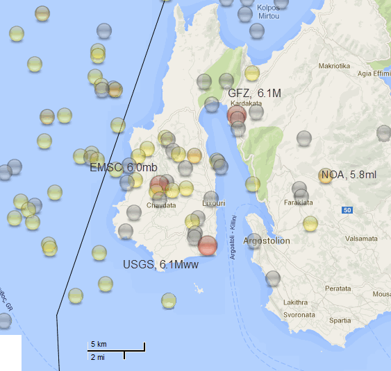
Locations of that 6ish quake in Kefalonia (also spelled Cephalonia) in Greece seem to vary quite a bit depending on which network you look at.
(click image for interactive map, opens in new tab/window)

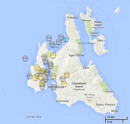
NOA have the aftershocks now = 33 of them
(click image for interactive map, opens in new tab/window)

(click image for interactive map, opens in new tab/window)

NOA have the aftershocks now = 33 of them
(click image for interactive map, opens in new tab/window)

edit on 01u252514 by muzzy because: a map is worth a thousand lines of text any day, hense 2 added (ha! and I had 7026 characters left
too!)
reply to post by muzzy
The aftershocks are spread over a diffuse region, aren't they?
As always, nice coverage Muzzy.
The aftershocks are spread over a diffuse region, aren't they?
As always, nice coverage Muzzy.
reply to post by Olivine
Thanks, I try my best with the limited time I have free in Summer.
The aftershocks seem to have developed into 2 sections, I haven't had time to look at the NOA data yet, these are mixed ( and duplicated no doubt) Network plots for the 27th Jan. off GSA interactive map
goo.gl...
Thanks, I try my best with the limited time I have free in Summer.
The aftershocks seem to have developed into 2 sections, I haven't had time to look at the NOA data yet, these are mixed ( and duplicated no doubt) Network plots for the 27th Jan. off GSA interactive map
goo.gl...
NOA (National Observatory of Athens) plots are the basis of that pattern, most of the other Networks plots are offshore to the West
only NOA data on map
I'm surprised there are not more aftershocks in the M1-M2 range, NOA usually pick up 600-1200 per month during background seismic activity across the country, so they do have the technology.
Greece interactive monthly maps 2013
I'll look into this closer when I get time and post a feature of EQ Archives
Too early too be worried?
reminds me of March 11 ,,but,,
Geo. not the same as a sub-ducted,, oceanic, convergence.
so any guess's?
of course Volcanic,, ie Santorini,, not out of the queastion,,
may actually, be the front runner.

reminds me of March 11 ,,but,,
Geo. not the same as a sub-ducted,, oceanic, convergence.
so any guess's?
of course Volcanic,, ie Santorini,, not out of the queastion,,
may actually, be the front runner.

4.1 & aftershocks in SE Nevada today.
And the Reykjanes Ridge putting it's 2 cents' worth in:
earthquake.usgs.gov...
1.9 43km WNW of Ivins, Utah 2014-01-29 03:35:02 UTC 0.0 km
2.3 43km SE of Caliente, Nevada 2014-01-29 02:17:49 UTC 0.0 km
1.5 42km SE of Caliente, Nevada 2014-01-29 01:59:05 UTC 0.0 km
3.0 40km WNW of Ivins, Utah 2014-01-29 01:39:00 UTC 4.7 km
4.0 42km WNW of Ivins, Utah 2014-01-29 01:30:27 UTC 6.5 km
2.9 42km WNW of Ivins, Utah 2014-01-28 21:33:45 UTC 7.0 km
1.7 43km WNW of Ivins, Utah 2014-01-28 18:22:47 UTC 7.0 km
0.9 42km WNW of Ivins, Utah 2014-01-28 17:35:04 UTC 6.8 km
0.9 41km WNW of Ivins, Utah 2014-01-28 17:25:08 UTC 8.0 km
1.1 43km WNW of Ivins, Utah 2014-01-28 17:06:22 UTC 7.7 km
1.3 41km WNW of Ivins, Utah 2014-01-28 17:04:56 UTC 10.7 km
2.3 41km WNW of Ivins, Utah 2014-01-28 16:58:35 UTC 10.5 km
1.0 44km WNW of Ivins, Utah 2014-01-28 16:55:26 UTC 7.6 km
1.9 41km WNW of Ivins, Utah 2014-01-28 16:51:00 UTC 7.2 km
1.2 44km WNW of Ivins, Utah 2014-01-28 16:49:49 UTC 7.3 km
2.5 41km WNW of Ivins, Utah 2014-01-28 16:46:43 UTC 10.6 km
2.4 41km WNW of Ivins, Utah 2014-01-28 16:46:15 UTC 7.4 km
0.7 39km WNW of Ivins, Utah 2014-01-28 16:38:33 UTC 6.0 km
1.6 43km WNW of Ivins, Utah 2014-01-28 16:31:24 UTC 5.8 km
1.9 42km WNW of Ivins, Utah 2014-01-28 16:29:20 UTC 6.2 km
2.1 41km WNW of Ivins, Utah 2014-01-28 16:24:35 UTC 6.7 km
2.1 41km WNW of Ivins, Utah 2014-01-28 16:24:00 UTC 5.4 km
1.9 43km WNW of Ivins, Utah 2014-01-28 16:22:49 UTC 0.0 km
2.2 40km WNW of Ivins, Utah 2014-01-28 16:21:43 UTC 2.6 km
4.1 43km WNW of Ivins, Utah 2014-01-28 16:20:11 UTC 7.2 km
And the Reykjanes Ridge putting it's 2 cents' worth in:
5.0 Reykjanes Ridge 2014-01-28 23:17:42 UTC 14.8 km
5.1 Reykjanes Ridge 2014-01-28 22:22:17 UTC 14.6 km
4.9 Reykjanes Ridge 2014-01-28 22:10:48 UTC 14.6 km
4.7 Reykjanes Ridge 2014-01-28 21:33:32 UTC 10.0 km
4.8 Reykjanes Ridge 2014-01-28 21:11:33 UTC 15.4 km
4.8 Reykjanes Ridge 2014-01-28 20:48:00 UTC 15.2 km
5.0 Reykjanes Ridge 2014-01-28 20:34:05 UTC 15.6 km
earthquake.usgs.gov...
Magnitude ML 4.2
Region GREECE
Date time 2014-01-29 09:14:24.0 UTC
Location 38.30 N ; 22.04 E
Depth 2 km
Distances 151 km W of Athens, Greece / pop: 729,137 / local time: 11:14:24.0 2014-01-29
27 km E of Pátra, Greece / pop: 163,360 / local time: 11:14:24.0 2014-01-29
2 km N of Selianítika / pop: 1,210 / local time: 11:14:00.0 2014-01-29

EMSC
edit on 29-1-2014 by Hellas because: (no reason given)
Another one in Gold Beach about the same size as the last one
M4.7 - 220km WSW of Gold Beach, Oregon
2014-01-30 00:02:55 UTC
earthquake.usgs.gov...
M4.7 - 220km WSW of Gold Beach, Oregon
2014-01-30 00:02:55 UTC
earthquake.usgs.gov...
reply to post by Nyiah
My friend said she was up all night because of the quakes in Nevada. She lives near Virginia City. She said the ground is continually shaking there. Very strange. Well, it's not strange for Nevada to have quakes, but this is an odd location for a swarm. Makes me wonder what's going on.
Pam
My friend said she was up all night because of the quakes in Nevada. She lives near Virginia City. She said the ground is continually shaking there. Very strange. Well, it's not strange for Nevada to have quakes, but this is an odd location for a swarm. Makes me wonder what's going on.
Pam
reply to post by Char-Lee
220km WSW is not IN Gold Beach.
Not your fault, I blame Useless for using those inane locations.
The correct location is "Off Coast of Oregon"
220km WSW is not IN Gold Beach.
Not your fault, I blame Useless for using those inane locations.
The correct location is "Off Coast of Oregon"
Warning out for NZ, M5+ possible in next few days.
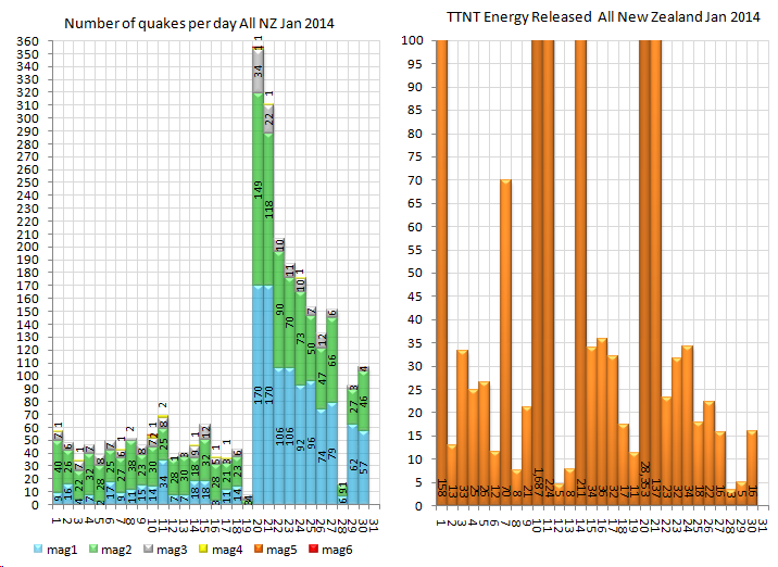
Muzzys Rules says the TTNT energy released on 28th (3) and 29th (5) were at dangerously low levels (below 10), which historically points to an impending M5+.
Could be that M5 that hasn't happened yet in the Eketahuna M6.3 Series, thats another earthquake Rule "Baths Law"

Something may have gone wrong at Geonet on the 28th also, only 16 quakes recorded, that is way out of the ordinary too.
Muzzys Rules says the TTNT energy released on 28th (3) and 29th (5) were at dangerously low levels (below 10), which historically points to an impending M5+.
Could be that M5 that hasn't happened yet in the Eketahuna M6.3 Series, thats another earthquake Rule "Baths Law"

edit on 01000000303014 by muzzy because: one to many s's
Something may have gone wrong at Geonet on the 28th also, only 16 quakes recorded, that is way out of the ordinary too.
edit on 01u303014 by
muzzy because: (no reason given)
Eketahuna, NI, NZ 6.3Mw 20/01/2014UTC, 7days timeline graph
 (click image for larger version, opens in
new tab/window)
summary
mag1= 899 , mag2= 434 , mag3= 55
mag4= 2 , mag5= 0 , mag6= 1
total= 1391 total energy released= 28492.294 TTNT
updated series page to 8 days

summary
mag1= 899 , mag2= 434 , mag3= 55
mag4= 2 , mag5= 0 , mag6= 1
total= 1391 total energy released= 28492.294 TTNT
updated series page to 8 days
M6.1 - 13km SSW of Visokoi Island 2014-02-01 03:58:43 UTC
Location
56.810°S 27.273°W depth=126.6km (78.7mi)
reply to post by muzzy
I have 135 records for GeoNet on the 28th Jan UTC in QVSData - M1+
@Nyiah
(Not shooting the messenger) We all know where that is then. Sounds Russian. Maybe in the Kamchatka area? Useless strikes again. What they meant to say was South Sandwich Islands region but they think no one knows where that is.
Do they think they are planning a roadmap? These sort of locations are OK for local lists but for global lists the Great Useless should realise (at the risk of repeating myself for the umpteenth time) that actually most people in the world have not got a clue about local names except in their own area and no, surprise surprise, the rest of the world has no clue where Gold Beach is either. I wonder how many Gold Beaches there are in the world. People should be given, as I have in QVSData, the option of receiving the information in local or global format. This attitude of Useless that we all know where everywhere is is basically just plain stupidity and myopia.
Something may have gone wrong at Geonet on the 28th also, only 16 quakes recorded, that is way out of the ordinary too.
I have 135 records for GeoNet on the 28th Jan UTC in QVSData - M1+
@Nyiah
3km SSW of Visokoi Island
(Not shooting the messenger) We all know where that is then. Sounds Russian. Maybe in the Kamchatka area? Useless strikes again. What they meant to say was South Sandwich Islands region but they think no one knows where that is.
Do they think they are planning a roadmap? These sort of locations are OK for local lists but for global lists the Great Useless should realise (at the risk of repeating myself for the umpteenth time) that actually most people in the world have not got a clue about local names except in their own area and no, surprise surprise, the rest of the world has no clue where Gold Beach is either. I wonder how many Gold Beaches there are in the world. People should be given, as I have in QVSData, the option of receiving the information in local or global format. This attitude of Useless that we all know where everywhere is is basically just plain stupidity and myopia.
edit on 1/2/2014 by PuterMan because: (no reason given)
There have been three earthquakes in Oklahoma. One almost reached 4M. Widespread. If you drew a line through them to make a tracking, you would get a
line nearly two hundred kilometers long.
Those of us that watch Yellowstone are glad to find that fella found a job and can keep the site going.
Those of us that watch Yellowstone are glad to find that fella found a job and can keep the site going.
I know it was a few days ago, but............
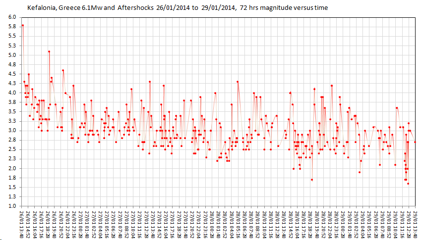
Kelafonia, Greece, 5.8ML (6.1Mw), 26/01/2014 and aftershocks at the 3 day (72hr) mark, to 29/01/2014 13:38:37UTC.
summary
mag1= 6 , mag2= 179 , mag3= 163
mag4= 22 , mag5= 2, mag6= 0
total=371 372
total energy released= 9,420.74 TTNT
(click image for EQArchives page, opens in new tab/window)

17 maps and 2 graphs, 445 words.
* Data is downloaded directly from National Observatory of Athens, I got 527 lines up to 31/01/2014 20:40:51, whereas DataPro only had 250something lines. Maybe I should be doing something else to get the revised data, or NOA download to DPro has been playing up.
Kelafonia, Greece, 5.8ML (6.1Mw), 26/01/2014 and aftershocks at the 3 day (72hr) mark, to 29/01/2014 13:38:37UTC.
summary
mag1= 6 , mag2= 179 , mag3= 163
mag4= 22 , mag5= 2, mag6= 0
total=
total energy released= 9,420.74 TTNT
(click image for EQArchives page, opens in new tab/window)

17 maps and 2 graphs, 445 words.
* Data is downloaded directly from National Observatory of Athens, I got 527 lines up to 31/01/2014 20:40:51, whereas DataPro only had 250something lines. Maybe I should be doing something else to get the revised data, or NOA download to DPro has been playing up.
edit on 02u313114 by muzzy because: changed something then read it then deleted it, realized that by using another image "biggerorangemarker"
for this series of maps the summary add up didn't pick it up and doesn't show 2x M5's, going back now to edit the page
edit on
02000000313114 by muzzy because: done
PuterMan
reply to post by muzzy
Something may have gone wrong at Geonet on the 28th also, only 16 quakes recorded, that is way out of the ordinary too.
I have 135 records for GeoNet on the 28th Jan UTC in QVSData - M1+
Oh? I'd better go back and do another download from the 28th then, could skew the numbers !
PuterMan
@Nyiah
3km SSW of Visokoi Island
(Not shooting the messenger) We all know where that is then. Sounds Russian. Maybe in the Kamchatka area? Useless strikes again. What they meant to say was South Sandwich Islands region but they think no one knows where that is.
Do they think they are planning a roadmap? These sort of locations are OK for local lists but for global lists the Great Useless should realise (at the risk of repeating myself for the umpteenth time) that actually most people in the world have not got a clue about local names except in their own area and no, surprise surprise, the rest of the world has no clue where Gold Beach is either. I wonder how many Gold Beaches there are in the world. People should be given, as I have in QVSData, the option of receiving the information in local or global format. This attitude of Useless that we all know where everywhere is is basically just plain stupidity and myopia.
I'd expect it to sound Russian, it was named by a Russian circumnavigating the Southern Ocean. I see no issues with the island's name here
And to be utterly honest, I used to think the SSI's were south of Oz somewhere around Bouvet for the longest time (see where I'm going with this? I didn't even mentally file Bouvet in the right geographic area for a time) So the idea of going with the grouping might not be any more of a help. People tend to need to ogle the map in conjunction with the list to remember the locations of places, like I did (and I'm a map freak! This is embarrassing stuff to admit) I do see your point, but I hope you see mine, too
Teeny one here:
M1.8 - 1km SW of Rye Brook, New York 2014-02-01 12:33:00 UTC
new topics
-
Inca stone masonry at Sacsayhuaman, Ollantaytambo and the Sun Temple
Ancient & Lost Civilizations: 6 hours ago -
President-Elect TRUMP Picks Former Florida A.G. PAM BONDI to be U.S. Attorney General.
2024 Elections: 10 hours ago
top topics
-
Gaetz withdraws from attorney general consideration
US Political Madness: 17 hours ago, 12 flags -
President-Elect TRUMP Picks Former Florida A.G. PAM BONDI to be U.S. Attorney General.
2024 Elections: 10 hours ago, 12 flags -
Putin will warn civilians in targeted areas
World War Three: 13 hours ago, 11 flags -
The Popular Vote does not matter
Political Issues: 14 hours ago, 8 flags -
Bridgewater Triangle
General Chit Chat: 17 hours ago, 7 flags -
A Mysterious Orb filmed over NYC by local news
Aliens and UFOs: 12 hours ago, 7 flags -
Inca stone masonry at Sacsayhuaman, Ollantaytambo and the Sun Temple
Ancient & Lost Civilizations: 6 hours ago, 2 flags
active topics
-
The Reactionary Conspiracy 6. Modus Operandi II
General Conspiracies • 136 • : MarxistDebunker2 -
Well we know Putins ICBMs won't fail in their silos
World War Three • 122 • : andy06shake -
A Mysterious Orb filmed over NYC by local news
Aliens and UFOs • 10 • : Encia22 -
Inca stone masonry at Sacsayhuaman, Ollantaytambo and the Sun Temple
Ancient & Lost Civilizations • 2 • : AdmireTheDistance -
Putin will warn civilians in targeted areas
World War Three • 34 • : andy06shake -
President-Elect TRUMP Picks Former Florida A.G. PAM BONDI to be U.S. Attorney General.
2024 Elections • 25 • : watchitburn -
All Talk No Walk Celebrities Blowing Smoke
US Political Madness • 57 • : PorkChop96 -
The Popular Vote does not matter
Political Issues • 12 • : AlroyFarms -
Well, here we go red lines crossed Biden gives the go ahead to use long range missiles
World War Three • 323 • : andy06shake -
Former DOJ charged with defrauding Rep. Matt Gaetz’s family over sex-crimes investigation
Propaganda Mill • 43 • : fringeofthefringe
