It looks like you're using an Ad Blocker.
Please white-list or disable AboveTopSecret.com in your ad-blocking tool.
Thank you.
Some features of ATS will be disabled while you continue to use an ad-blocker.
share:
Several hours before Typhoon Haiyan made landfall in the Philippines on Nov. 7, DigitalGlobe activated FirstLook, an online service that provides satellite imagery of large scale disasters. Their satellites collected more than 7,300 square miles of imagery in the areas hardest hit by the typhoon — one of the strongest storms to ever make landfall.
Typhoon Haiyan's impact revealed in before-and-after satellite images

Digital Globe/First Look is pretty interesting- has anyone ever heard of this being used for disasters? I've never seen/heard of them using this type of method to gauge damage on a larger scale, certainly will be a useful tool.
Typhoon Haiyan officially dissipated yesterday 11/11/2013 and the confirmed death toll has already surpassed the deadliest US hurricane (Katrina) in the last 75+ years, current death toll 1800+ and climbing.
DigitalGlobe/FirstLook Website
MODS: If this is in the 'wrong' section please feel free to move it!
edit on 12-11-2013 by ragiusnotiel because: added pictures & additional
info
wind and water are a hell of a thing aint they.
can erase years from the face of the earth.
i feel for all those people.
can erase years from the face of the earth.
i feel for all those people.
edit on 12-11-2013 by hounddoghowlie because: (no reason given)
Just one freaking mess. I really hope the people quickly get the aid they seek . This is another reminder to the whole world that each and every one
of us better have backup plans in case things go south. The government isn't going to be there to help us.
Tragic
Tragic
reply to post by hounddoghowlie
Very true, and if that wasn't horrible enough just seeing all the loss of life would be devastating. From the photo's I've seen there are bodies everywhere, I don't know if I could deal with that. I know my first instinct would be to check if they're breathing etc, and realizing they're all dead must be absolutely heart-wrenching on top of the destruction all around you.
Very true, and if that wasn't horrible enough just seeing all the loss of life would be devastating. From the photo's I've seen there are bodies everywhere, I don't know if I could deal with that. I know my first instinct would be to check if they're breathing etc, and realizing they're all dead must be absolutely heart-wrenching on top of the destruction all around you.

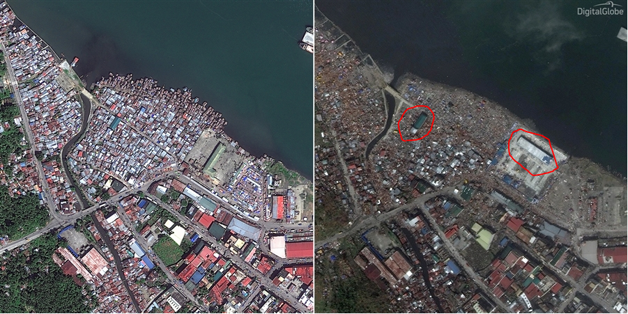
Just a couple of anomalies I noticed;
Why does the object/structure circled on the left appear to have relatively grown in size?
And what can account for the seeming rotation of the object/structure circled on the right?
reply to post by OneFreeMan
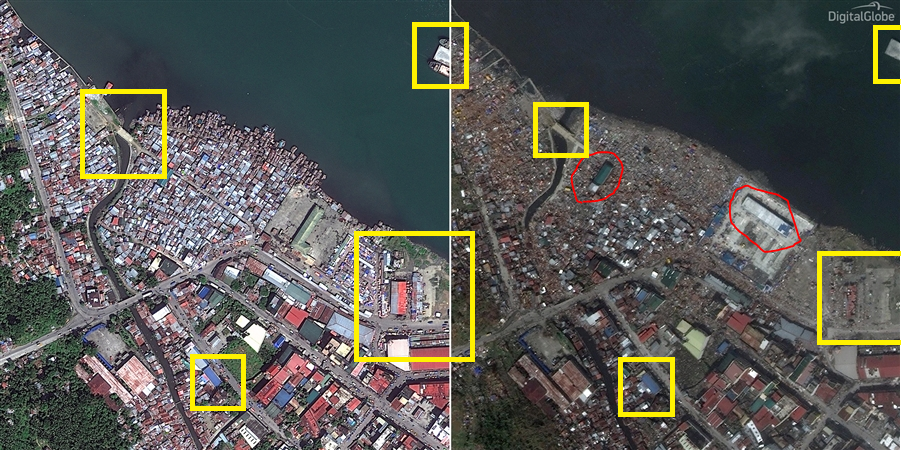
the one in the square appears to have been changed, like the building has been moved.
there is another shot in the link that the roof of the before shot was green and the after shot is red.
there's no telling ho old the google earth before shots are from this link.
ETA: here the building with the roof. i cropped it some.

edit on 12-11-2013 by hounddoghowlie because: (no reason given)
OneFreeMan
Just a couple of anomalies I noticed;
Why does the object/structure circled on the left appear to have relatively grown in size?
And what can account for the seeming rotation of the object/structure circled on the right?
My best guess for the 2nd one would be that perhaps the building was turned on its side or back? I feel like white would be used for siding ahead of roof/foundation.
The first one, I don't know- the satellite pictures seem slightly different- and the second one does seem to be zoomed in a bit more, so maybe that's why it looks bigger? Also less around it to confine the boundaries?
(The zooming is obvious if you look at the parking lot just under the coastline on the right side. That lot has clearly visible lines and the first picture places it further to the left than the second.)
If that doesn't make sense to anyone other than me let me know and I'll open up paint
See below: Several things are actually bigger in the section picture, I think it's just zoom and/or satellite position.

edit on 12-11-2013 by ragiusnotiel because: added picture
reply to post by OneFreeMan
To your first question; it seems that the resolution and distance between the two has changed. The first is clearly at a different field of view than the second.
To your second question; I am not sure. Do you have dates to the photos? Maybe major renovations have occurred? Or maybe they were manipulated...
Is it just me or does it look like that river was obstructed with debris? I wonder if it's still flowing through or adding additional flooding etc.
It looks larger because it has a visible shadow once all the buildings around it were leveled.
The other object might be a completely different object. Is that a shipyard? Possibly a different barge or ship, or maybe they rotated it before strapping it down to face the prevailing winds.
The other object might be a completely different object. Is that a shipyard? Possibly a different barge or ship, or maybe they rotated it before strapping it down to face the prevailing winds.
reply to post by OneFreeMan
i enlarged the picture. it looks like the yard was redone.

see how the old building has a L shape, and the new one is just long and new buildings with blue roofs in front.
reply to post by ragiusnotiel
yes in is full of debris

ETA: i read futher down in the op's link and saw this.
so it seems that the before pictures are a about a year and a half older.
i enlarged the picture. it looks like the yard was redone.

see how the old building has a L shape, and the new one is just long and new buildings with blue roofs in front.
reply to post by ragiusnotiel
yes in is full of debris

edit on 12-11-2013 by hounddoghowlie because: (no reason given)
ETA: i read futher down in the op's link and saw this.
The satellite images above were first taken on Feb 23, 2012 and again on Nov. 10, 2013, after Haiyan wiped out Tacloban, one of the first islands in the direct path of the ferocious tropical storm. Click on the images to view them larger.
so it seems that the before pictures are a about a year and a half older.
edit on 12-11-2013 by hounddoghowlie because: (no reason
given)
OneFreeMan
Just a couple of anomalies I noticed;
Why does the object/structure circled on the left appear to have relatively grown in size?
And what can account for the seeming rotation of the object/structure circled on the right?
As for the 2nd one, water is extremely powerful.
Looks as tho the water swept it sideways.
Katrina played hell with the Mississippi gulf coast, including moving large casino barges inland and away from their original location by a mile or so.
Not to mention wiped the houses clean off their foundation, nothing left but a slab of concrete.
They had a 30 ft. storm surge around Bioloxi/Gulf Port/Waveland, Ms. so I would think that they endured about the same if not worse from Typhoon Haiyan
My husband and I went there as soon as they reopened the roads and it was total devastation....
I can only imagine what those poor people went through with the typhoon and are still going through.
My thoughts and prayers go out to them.
edit on 13-11-2013 by snarky412 because: (no reason given)
reply to post by hounddoghowlie
Yea I noticed the roof being a completely different color- which is weird because I believe the article said they were told before Haiyan hit to get the satellite pictures ( I could have misread but I doubt it). The angle is different as well. But I supposed they could have used google earth to get the first ones, but isn't that kind 'defeating the purpose' ? I mean how often does google maps get updated? I know my driveway looked the same for quite some time even with it being redone and all. Rescue would certainly be easier with more accurate maps.
*For the record I was able to find one of the places on Google Maps street view although the angle of it is completely different. (General Area search: "Eastern Visayas › Leyte › Tacloban City › Barangay 69")
The Dreaded Double Post
edit on 13-11-2013 by ragiusnotiel because: (no reason given)
reply to post by ragiusnotiel
i just added a edit to my post from the link in your op.
the before pictures seem to be taken on Feb 23, 2012.
i just added a edit to my post from the link in your op.
the before pictures seem to be taken on Feb 23, 2012.
The satellite images above were first taken on Feb 23, 2012 and again on Nov. 10, 2013, after Haiyan wiped out Tacloban, one of the first islands in the direct path of the ferocious tropical storm. Click on the images to view them larger.
edit on 13-11-2013 by hounddoghowlie because: (no reason given)
hounddoghowlie
reply to post by ragiusnotiel
i just added a edit to my post from the link in your op.
the before pictures seem to be taken on Feb 23, 2012.
The satellite images above were first taken on Feb 23, 2012 and again on Nov. 10, 2013, after Haiyan wiped out Tacloban, one of the first islands in the direct path of the ferocious tropical storm. Click on the images to view them larger.
edit on 13-11-2013 by hounddoghowlie because: (no reason given)
aha! Thank you!
reply to post by snarky412
I believe the President of the Philippines said today (or yesterday now) that those estimates had been off.
Typhoon Haiyan's toll: More than 1800 dead
Either way it's still terrible for the people there.
Seeing Katrina's damage up close and personal must have been horrible I can't imagine what being there was like.
I'm glad they have taken it from 10,000 presumed dead to 2,500. Over a half million without homes as well.
www.bbc.co.uk...
I have no clue about this but when you live in typhoon or tornado country aren't there underground shelters for most homes? This wouldn't be too helpful if at sea level or if surging seas but I'm wondering if that is how most survived.
This goes to show that even though these people had warning there really isn't much to do to protect all of the people when it comes to the fury of Mother Nature. Now there is shock and distress from the government down, people looting in some cases, difficulties with getting stuff where it needs to be. I only hope an opportunity is not made from this via the loss of more lives through trafficking or more crime. Keeping civil order is likely going to take some donations of military personnel from other Countries.
new topics
-
Former ‘GMA Producer’ Sues NPR-Legacy Media Exposed
Propaganda Mill: 13 minutes ago -
New Footage - Randy Rhoads 1979 LIVE Guitar Solo Footage at the Whisky - Pro Shot
Music: 1 hours ago -
Happy Hanukkah…
General Chit Chat: 1 hours ago -
A Merry Christmas.
General Chit Chat: 8 hours ago
top topics
-
Cold Blooded Killers on Christmas!! GRRRRrrr!!
Pets: 15 hours ago, 10 flags -
A Merry Christmas.
General Chit Chat: 8 hours ago, 6 flags -
Former ‘GMA Producer’ Sues NPR-Legacy Media Exposed
Propaganda Mill: 13 minutes ago, 3 flags -
Happy Hanukkah…
General Chit Chat: 1 hours ago, 2 flags -
New Footage - Randy Rhoads 1979 LIVE Guitar Solo Footage at the Whisky - Pro Shot
Music: 1 hours ago, 2 flags
active topics
-
Former ‘GMA Producer’ Sues NPR-Legacy Media Exposed
Propaganda Mill • 1 • : LocutusofBorg001 -
Plane Crash Today --Azerbaijanian E190 passenger jet
Mainstream News • 29 • : LocutusofBorg001 -
Happy Hanukkah…
General Chit Chat • 1 • : FeeshJefe -
It's Offical Now
US Political Madness • 24 • : Lazy88 -
Dutch Investigators Give Results of MH17 Probe to Families
Breaking Alternative News • 294 • : Lazy88 -
New Footage - Randy Rhoads 1979 LIVE Guitar Solo Footage at the Whisky - Pro Shot
Music • 0 • : gortex -
Post A Funny (T&C Friendly) Pic Part IV: The LOL awakens!
General Chit Chat • 7958 • : underpass61 -
London Christmas Market BANS Word ‘Christmas’
Social Issues and Civil Unrest • 54 • : BernnieJGato -
Statements of Intent from Incoming Trump Administration Members - 2025 to 2029.
2024 Elections • 55 • : Xtrozero -
Orange County Makes Shoplifting a Felony
Other Current Events • 24 • : Xtrozero
