It looks like you're using an Ad Blocker.
Please white-list or disable AboveTopSecret.com in your ad-blocking tool.
Thank you.
Some features of ATS will be disabled while you continue to use an ad-blocker.
share:
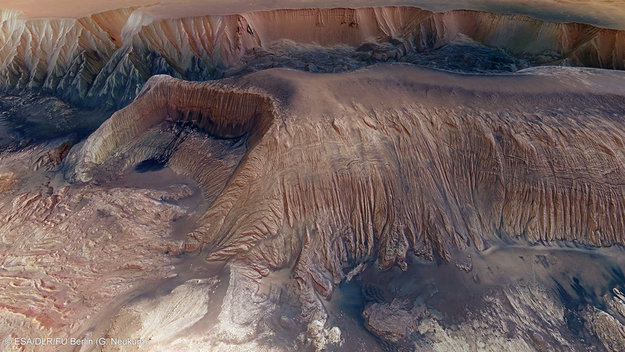
Full image can be downloaded here:
spaceinimages.esa.int...
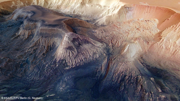
Full image can be downloaded here:
spaceinimages.esa.int...
(I recommend the TIF format, awesome also as desktop backgrounds )
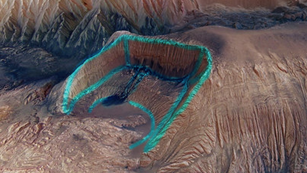
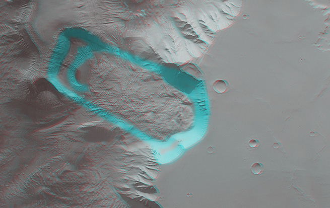
The "Hebes Chasm" on Mars.
There is a mountain, as high as Mt. Everest (8000m) deep in a Valley, the valley itself is 8000m deep.
"Hebes Chasma is an enclosed trough, almost 8000 m deep, in Valles Marineris, the Grand Canyon of Mars, where water is believed to have flowed. The High Resolution Stereo Camera (HRSC) on ESA’s Mars Express studied the area providing new pictorial clues to its history. "
In the first pic, the mountain inside the giant valley, the sides alone are approx. 200km in length.
edit on
42013RuThursdayAmerica/Chicago50PMThursdayThursday by NoRulesAllowed because: (no reason given)
reply to post by NoRulesAllowed
This just proves that Nasa takes hugh definition pictures of Mars and that they are very careful for which ones they give out the public
This just proves that Nasa takes hugh definition pictures of Mars and that they are very careful for which ones they give out the public
Thanks for sharing, the pics are great!
That one section of canyon looks like an impact crater...
That one section of canyon looks like an impact crater...
reply to post by AthlonSavage
I dunno mang. Been following mars for more than a decade, too much radiation, to inhospitable, I guess you never know though..
IMO Mars is fantastic, but sadly has nothing that NASA should hide.
Sorry, that's the Shill in me coming out..
I dunno mang. Been following mars for more than a decade, too much radiation, to inhospitable, I guess you never know though..
IMO Mars is fantastic, but sadly has nothing that NASA should hide.
Sorry, that's the Shill in me coming out..
reply to post by NoRulesAllowed
Nice pics for sure. The contrast is striking and the sediment resembles shadows or oil in some areas.

Looks like a mining area where a giant shovel took out a chunk and some martian oil leaked out.
"Most likely eh?" The area at bottom right looks like ice with a subtle reflection.
Nice pics for sure. The contrast is striking and the sediment resembles shadows or oil in some areas.

Looks like a mining area where a giant shovel took out a chunk and some martian oil leaked out.
A dark patch appears to pool like spilt ink across the debris. It is most likely loose material that has slid down the walls from an intermediate layer. Melted ice could have played a role by weakening the rocks to create its flow-like appearance.
"Most likely eh?" The area at bottom right looks like ice with a subtle reflection.
edit on 11-10-2013 by speculativeoptimist because: (no
reason given)
The words "perspective view" indicate that the image has been manipulated and overlayed on a terrain model, like what Google Earth does. This is the image which was used:
The details of the central mesa inside Hebes Chasma are seen in close-up detail in this perspective view.
The resolution of the image is about 15m/pixel.
reply to post by VoidHawk
Yeah a square crater. Its just the way the canyon absorbed it.
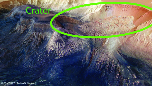
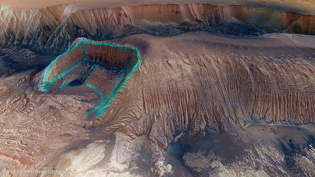
The way that ridge is compressed and lifted seems to have been struck
Yeah a square crater. Its just the way the canyon absorbed it.


The way that ridge is compressed and lifted seems to have been struck
edit on 11-10-2013 by AbleEndangered because: added pics and
comment
reply to post by Phage
So where is the UFO from the picture to be found in these shots the op provided?
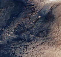
So where is the UFO from the picture to be found in these shots the op provided?

AthlonSavage
reply to post by NoRulesAllowed
This just proves that Nasa takes hugh definition pictures of Mars and that they are very careful for which ones they give out the public
The pictures in this thread are from the European Space Agency (ESA): www.esa.int...
Those of you with red-green glasses can see it in 3D:
spaceinimages.esa.int...
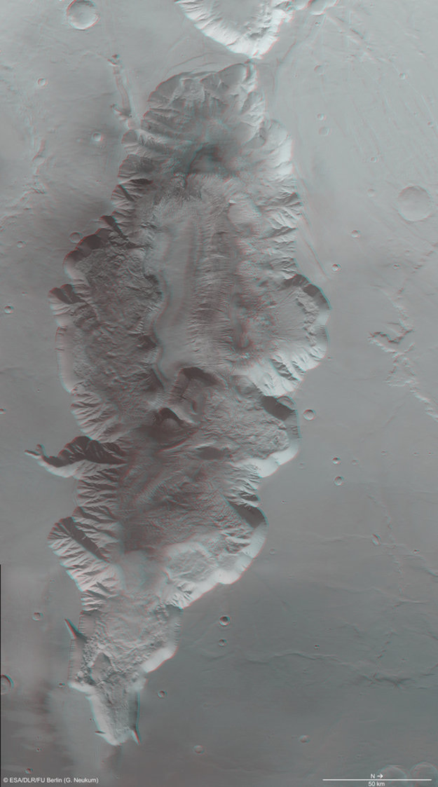
It looks awesome in 3D!
This area can be explored in great detail in Google Earth (Mars mode), if you switch to "CTX Mosaic" in Global Maps. For example, here's that dark "pool" in the square feature of the chasma:
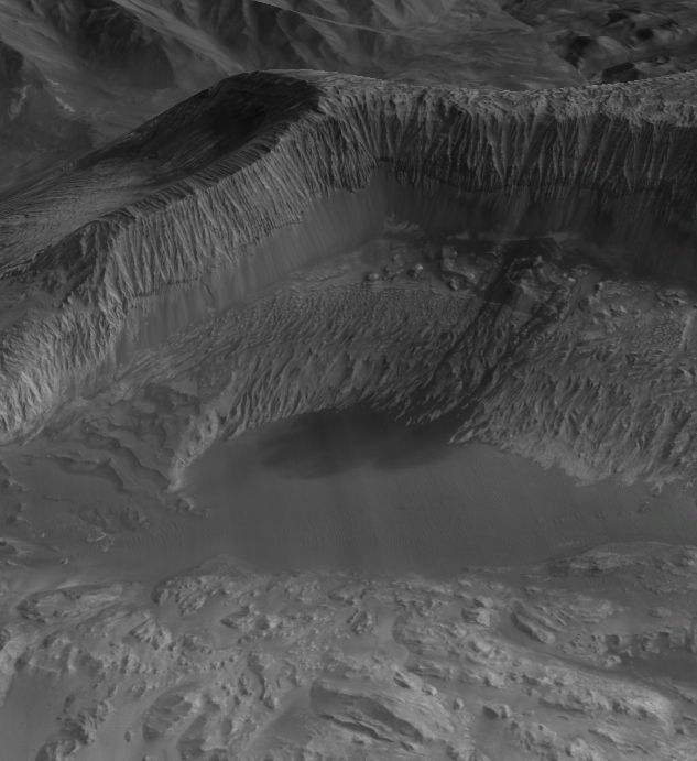
edit on 11-10-2013 by wildespace because: (no reason given)
Yeah, it looks sweet with glasses.
There is my crater, if its a crater I get to name it!! right??
Yeah I noticed that pool and highlighted in other pic. There is a dark layer in that rock as well.
There is my crater, if its a crater I get to name it!! right??

wildespace
Yeah I noticed that pool and highlighted in other pic. There is a dark layer in that rock as well.
edit on 11-10-2013 by AbleEndangered
because: addition
reply to post by Phage
I'm gonna name it "Crater of Dark Water"!!
after:
"The Pirates of Dark Water" - Intro
www.youtube.com/watch?v=LH_7SS534X8
www.youtube.com...
I'm gonna name it "Crater of Dark Water"!!
after:
"The Pirates of Dark Water" - Intro
www.youtube.com/watch?v=LH_7SS534X8
www.youtube.com...
edit on 11-10-2013 by AbleEndangered because: typo
AthlonSavage
reply to post by NoRulesAllowed
This just proves that Nasa takes hugh definition pictures of Mars and that they are very careful for which ones they give out the public
These are not true "pictures", but rather they are 3D computer generated terrains (using elevation data and image data).
Basically, ESA is constructing a computer-generated 3D model of the terrain, and then they are overlaying the picture on top of it, and adding false color. They then manipulate the 3D model in a computer by turning it so the view is more horizontal.
So there is quite a bit of manipulation and computer generation going on with these images.
edit on 10/11/2013 by Soylent Green Is People because: (no reason given)
Looks like a WHOLE lot of water had eroded those canyon walls.
That sure looks apparent.
That sure looks apparent.
abeverage
Looks like a WHOLE lot of water had eroded those canyon walls.
That sure looks apparent.
It's been apparent for a while. NASA and ESA have already found river beds and what look like shore of large lakes or seas. Planetary scientists are pretty well convinced that a lot of water once flowed on the surface of Mars.
Soylent Green Is People
abeverage
Looks like a WHOLE lot of water had eroded those canyon walls.
That sure looks apparent.
It's been apparent for a while. NASA and ESA have already found river beds and what look like shore of large lakes or seas. Planetary scientists are pretty well convinced that a lot of water once flowed on the surface of Mars.
Yes I know this but thanks!
Since those images from ESA are false-colour, here's a true-colour (RGB) image from MRO's HiRISE camera, at 25 cm/pixel resolution:
hirise-pds.lpl.arizona.edu...

Source: hirise.lpl.arizona.edu...
Some cool sand layering there.
P.S. a bit disappointed that the guy ranting about NASA got a whole bunch of stars, and my reply to him got only one. But I guess that's how it works at ATS.
hirise-pds.lpl.arizona.edu...

Source: hirise.lpl.arizona.edu...
Some cool sand layering there.
P.S. a bit disappointed that the guy ranting about NASA got a whole bunch of stars, and my reply to him got only one. But I guess that's how it works at ATS.
VoidHawk
NoRulesAllowed
A square crater?
Indeed! Someone needs to prove that this is not a computer generated rendering,
similar to those used in manys a sci-fi movie!
NASA are not to be trusted. Simple as!
edit on 11/10/2013 by UpEndedWorld because: format
Arrrgh. Double post.
See intended post below.
Sorry, but I clicked "quote" instead of "edit"
See intended post below.
Sorry, but I clicked "quote" instead of "edit"
edit on 10/11/2013 by Soylent Green Is People because: (no reason given)
new topics
-
racist rant, but she made the arguement to get rid of DEI
US Political Madness: 7 minutes ago -
Well we know Putins ICBMs won't fail in their silos
World War Three: 21 minutes ago -
Why isn't Psychiatry involved?
Social Issues and Civil Unrest: 6 hours ago -
Help in song interpretation
Music: 8 hours ago -
FEMA Head Admits Agency Skipped 20 Homes with Trump Signs
Mainstream News: 11 hours ago -
Yet another Hack...
Rant: 11 hours ago
top topics
-
FEMA Head Admits Agency Skipped 20 Homes with Trump Signs
Mainstream News: 11 hours ago, 13 flags -
Yet another Hack...
Rant: 11 hours ago, 12 flags -
Gaetz ethics investigation results "hacked".
US Political Madness: 15 hours ago, 10 flags -
Well we know Putins ICBMs won't fail in their silos
World War Three: 21 minutes ago, 4 flags -
Why isn't Psychiatry involved?
Social Issues and Civil Unrest: 6 hours ago, 3 flags -
Help in song interpretation
Music: 8 hours ago, 1 flags -
racist rant, but she made the arguement to get rid of DEI
US Political Madness: 7 minutes ago, 0 flags
active topics
-
Well, here we go red lines crossed Biden gives the go ahead to use long range missiles
World War Three • 314 • : ufoorbhunter -
Russia Ukraine Update Thread - part 3
World War Three • 6839 • : onestonemonkey -
Well we know Putins ICBMs won't fail in their silos
World War Three • 5 • : andy06shake -
racist rant, but she made the arguement to get rid of DEI
US Political Madness • 0 • : network dude -
Why isn't Psychiatry involved?
Social Issues and Civil Unrest • 7 • : BrucellaOrchitis -
Post A Funny (T&C Friendly) Pic Part IV: The LOL awakens!
General Chit Chat • 7803 • : PorkChop96 -
WATCH LIVE: US Congress hearing on UFOs, unidentified anomalous phenomena
Aliens and UFOs • 150 • : gortex -
Kentucky goes medical marijuana Jan 1 2025
Other Current Events • 27 • : 38181 -
Waterloo in 20mm world's largest diorama (on view at NAM Chelsea Oct 20 & 21) new pics added 10 -16
Member Art • 51 • : BrucellaOrchitis -
DefCon Teetering on Escalation
World War Three • 46 • : ADVISOR
