It looks like you're using an Ad Blocker.
Please white-list or disable AboveTopSecret.com in your ad-blocking tool.
Thank you.
Some features of ATS will be disabled while you continue to use an ad-blocker.
share:
How To Calculate Height of Moon Objects Like A Pro
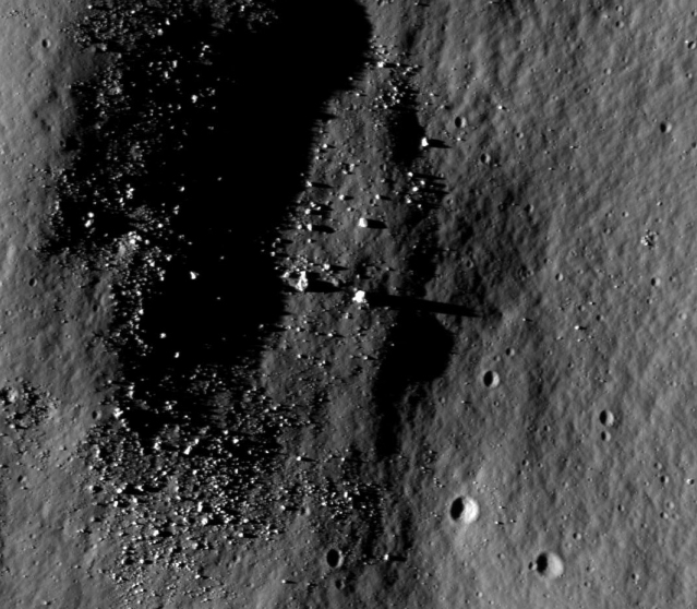
Here is a guide on calculating height of objects on the Moon using major variables that affect the shadow length such as how high the Sun is in the sky and what kind of slope the shadow is lying on. No special tools required. Would be interesting to see what the calculated height of this object turns out to be. The example used in the guide is an actual object found on lunar farside with shadow length of 225m and calculated height of 47m, which is not too shabby, whatever it might be.
Here is a guide on calculating height of objects on the Moon using major variables that affect the shadow length such as how high the Sun is in the sky and what kind of slope the shadow is lying on. No special tools required. Would be interesting to see what the calculated height of this object turns out to be. The example used in the guide is an actual object found on lunar farside with shadow length of 225m and calculated height of 47m, which is not too shabby, whatever it might be.
Originally posted by PINGi14
How To Calculate Height of Moon Objects Like A Pro
Here is a guide on calculating height of objects on the Moon using major variables that affect the shadow length such as how high the Sun is in the sky and what kind of slope the shadow is lying on. No special tools required. Would be interesting to see what the calculated height of this object turns out to be. The example used in the guide is an actual object found on lunar farside with shadow length of 225m and calculated height of 47m, which is not too shabby, whatever it might be.
Yeah, but can you accurately get all of the data required to make that calculation?
As 'wildspace' showed in his post here (click), the depression to the right of the object in his example made a huge difference in the length of the shadow.
Do we have easy access to enough information to accurately gather the data on depressions such as this?
what ever became of buzz aldrin and the monolith on one of the moons of mars ?
Originally posted by billdadobbie
what ever became of buzz aldrin and the monolith on one of the moons of mars ?
You mean this?
I would love to know what it is as well. It is a larger structure but no more interesting then this temple shaped structure on Eros433
Originally posted by ShadowLink
I think the obvious escapes you.
The hill that the "Monolith" is on casts an almost equally long shadow.
Since the "Monolith" is on top of the hill, I would expect it to cast a slightly longer shadow.
Nothing more than an oblong rock sitting vertically on top of a hill. Pretty sure if you look around ATS you will find many more "Monoliths".
I would love to see some real s&@$ on the moon as much as the next guy, but don't look too deeply or you're gonna be the next guy posting pictures of Guinea Pig Rocks.
Even if it was on a flat surface would there not be a need to have a known entity, like a bus or Nelson's pillar nearby, and also casting a shadow to make an accurate height calculation from a shadow?
edit on 25-6-2013 by smurfy because: Text.
reply to post by smurfy
But with a slope you can't do it...unless you know the angle of the slope.
Nope. Not if we know the elevation of the Sun above the local horizon. In this case it would be about 27º.
Even if it was on a flat surface would there not be a need to have a known entity, like a bus or Nelson's pillar nearby to make an accurate height calculation from a shadow?
But with a slope you can't do it...unless you know the angle of the slope.
edit on 6/25/2013 by Phage because: (no reason given)
Originally posted by Phage
reply to post by smurfy
Nope. Not if we know the elevation of the Sun above the local horizon. In this case it would be about 27º.
Even if it was on a flat surface would there not be a need to have a known entity, like a bus or Nelson's pillar nearby to make an accurate height calculation from a shadow?
But with a slope you can't do it...unless you know the angle of the slope.
edit on 6/25/2013 by Phage because: (no reason given)
We need to investigate closer!
This thing could be either 2ft tall or 50, and judging by the straight edges on it, I find it fascinating.
I'm trying to get the word Obelisk out of my head but it just gets louder and louder. Make it go away Phage!
Originally posted by SayonaraJupiter
Originally posted by ShadowLink but don't look too deeply or you're gonna be the next guy posting pictures of Guinea Pig Rocks.
I don't think that this is a Guinea Pig Rock. The shadow is >100m and by orders of magnitude it is longer than any other shadow feature in the area which can be found on Mons Hansteen.
I am not good at trigonometry and I failed geometry. But this image might be useful to someone who could do the math to figure out the relative elevations and the shadow distances involved, which in the end, would compute the true dimensions of this monolithic rock!
I wish I was good at math but it just isn't my thing.
I just noticed your ATS userid! Shadows indeed.....
The important things are your solar angle, monolith height.
Assuming a flat surface, and that a solar angle of 0 is the sun on the horizon, and a solar angle of 90 is the sun directly above (mid-day), then the length of the shadow is:
shadow length = monolith height x tan (90 - solar-angle)
Right at sunset/sunrise, the shadow length will be infinite.
If we want the monolith height from the shadow length, just divide instead:
monolith height = shadow length / tan(90 - solar-angle)
There is also the curvature of the Moon to take into account, but that would be dominated by the curvature of the hill/crater.
Originally posted by stormcell
The important things are your solar angle, monolith height.
Assuming a flat surface, and that a solar angle of 0 is the sun on the horizon, and a solar angle of 90 is the sun directly above (mid-day), then the length of the shadow is:
shadow length = monolith height x tan (90 - solar-angle)
Right at sunset/sunrise, the shadow length will be infinite.
If we want the monolith height from the shadow length, just divide instead:
monolith height = shadow length / tan(90 - solar-angle)
There is also the curvature of the Moon to take into account, but that would be dominated by the curvature of the hill/crater.
I gotta point out the small mix-up in the formula you posted because it will result in grossly inaccurate height calculations, almost opposite of what the correct answer should be. The fix is simple, we just need to swap the places for object height and shadow length in your formula.
Instead of
monolith height = shadow length / tan(90 - solar-angle)
It should be
monolith height = shadow length * tan(90 - solar-angle)
The effect of slope although minor compared to sun angle, is also easily obtained using the line-tool from LROC quick map as shown on the tutorial at top of this page.
Originally posted by wildespace
Replies above are correct, a shadow cast downslope will be longer than on flat ground.
Anyhoo, I like to have an idea of what I'm looking at from several LRO images of the same location, taken at different sun angles. Notice that in the WAC image (the wide angle one) there's no hint of the dark vent; in fact that spot is actually bright. The articles on Mons Hansteen say it's thought to be "an extrusive volcanic mound". I'm not an expert on volcanism, so maybe this thing is somehow different from a typical volcano. This may be just a big pile of material pushed out of the interior by volcanic forces.
Here are the NAC images covering that area:
wms.lroc.asu.edu...
wms.lroc.asu.edu...
wms.lroc.asu.edu...
wms.lroc.asu.edu...
wms.lroc.asu.edu...
wms.lroc.asu.edu...
I'll try to zero-in on the "vent" if I can, and post screenies here.
P.S. ok, here they are:
OP's image, M166182355RC
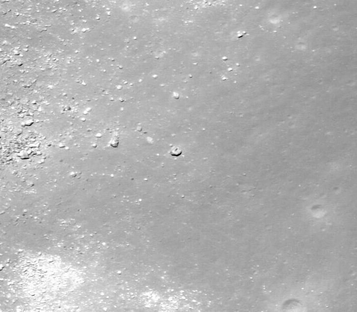
Aha! The best image yet, M140237118RC (0.489 m/p resolution)
Sun is overhead, so almost no shadow, but the great resolution shows it to be nothing but a big rock.
P.P.S. That shadowed area that caught your eye seems to be simply a slope of a hill or ridge. It's on the edge of the large relatively flat area to the right of the monolith.
Oh, just found out that the QuickMap allows you to make a 3D visualisation of the selected terrain
A closeup, very rough geometry, but shows that it's a big rounded slope (click and drage image to rotate the view): target.lroc.asu.edu...
A wider view of the area: target.lroc.asu.edu...
Salute to Wildespace! Thank you for the links and images! The 3D visualizations are the cat's meow.
I agree with your P.P.S.
It's only been 2 pages but we have already learned a lot about Mons Hansteen.
Mons Hansteen is considered a lunar 'red spot'. See this report for definition of 'red spot'.
www.planetary.brown.edu...
National Geographic even went so far as to claim Mons Hansteen is a "new" type of moon volcano.
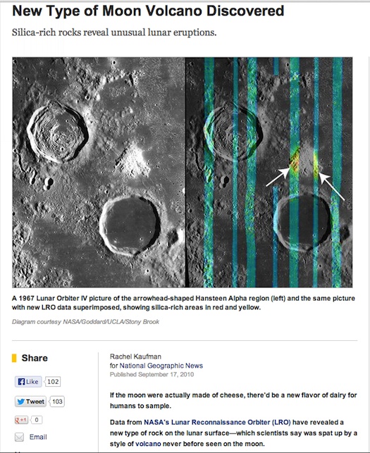
Sketch of the monolith >100m shadow is just to illustrate the downward slope from west to east with the sun at ~27 degrees.
Mons Hansteen is considered a lunar 'red spot'. See this report for definition of 'red spot'.
www.planetary.brown.edu...
National Geographic even went so far as to claim Mons Hansteen is a "new" type of moon volcano.

Sketch of the monolith >100m shadow is just to illustrate the downward slope from west to east with the sun at ~27 degrees.

The detective in me is wondering whether there is any Apollo mapping or metric coverage for that area. We might see the shadow pointing the other way
at similar sun angles to the ones we've seen. How does one go about finding those Apollo images for that particular location?
Originally posted by Phage
reply to post by smurfy
Nope. Not if we know the elevation of the Sun above the local horizon. In this case it would be about 27º.
Even if it was on a flat surface would there not be a need to have a known entity, like a bus or Nelson's pillar nearby to make an accurate height calculation from a shadow?
But with a slope you can't do it...unless you know the angle of the slope.
edit on 6/25/2013 by Phage because: (no reason given)
I considered that the Sun would be part of the equation, but I thought there was more to it. There you go!
Originally posted by VoidFire
It would make sense if it was a volcanic vent that had the outer part of the Volcano eroded away. That's where some similar structures originate from here on Earth as well, from eroded away volcanoes leaving only the Volcanic plug. I'm just saying because there are many wind storms on Mars, and the erosion and weathering may have also come from previous water sources as well.
Very beautiful and interesting geologic phenomena too.
Yes, and with no wind, water on the moon, the structures could be millions or billions of years old.
reply to post by SayonaraJupiter
I worked for a government agency involved in the Apollo 'Lunar Landing Missions' as a
photogrammetrist and cartographer compiling detailed photo maps using stereo pairs of overlapping satellite photography for NASA.
Using the state of the art desk size optical steroscopic instruments, a tiny dot of white light floating above the surface in stereo was lowered by the technician to the low point on an object where a reading was taken on the instrument, then the point of light was raised to take a reading of the highest point; finding the true height was just the difference in the two readings.
Among other features, we mostly were measuring crater depths and rim hights, especially the craters that could effect landings, which were down to very small size craters. Each crater measured had two points with values, the lowest point at the bottom of the crater, and the highest point on the rim, with the surronding surface as an index. In order to accurately measure these in stereo, the satellite ephemeris data was required.
In order to measure rocks and shards accurately using stereo pairs of photography, ephemeris satellite data, and an accurate steroscopic instrument with measuring capabilities would be necessary to know the true height of the feature. Uneven ground would have no effect on measuring it with stereoscopic instruments, as compared to shadow estimates.
Possibly the answer to the height of this feature would be one of the NASA steroscopic compiled maps with height and depth values, if one exists in this area.
Originally posted by wildespace
The detective in me is wondering whether there is any Apollo mapping or metric coverage for that area. We might see the shadow pointing the other way at similar sun angles to the ones we've seen. How does one go about finding those Apollo images for that particular location?
The PDS Archive Interface allows you to set the map to show Metric Camera coverage. This interface was originally created for the Apollo Image Archive. That site has the good zoomable interface for the Panoramic Camera & Metric Camera images. Browse here.
There is also the Apollo Image Atlas (similar name, different site).This allows you to search by location or feature name. It has scans of ALL of the Apollo imagery, and access to all of the Ranger & Lunar Orbiter images.
Unfortunately, Mons Hansteen is well into the western hemisphere of the Moon. All three of the Apollo J-Missions landed in the eastern hemisphere, and since they landed in the local morning, the sun had not yet risen on Mons Hansteen. It was in-frame in Mapping Camera images AS16-M-2998 & AS16-M-2999 - down in the lower left where, as you can see, it is dark.
Talk about long shadows - both of these images have them in spades, thanks to the Sun just peaking over the horizon!
Originally posted by lunarcartographer
reply to post by SayonaraJupiter
I worked for a government agency involved in the Apollo 'Lunar Landing Missions' as a
photogrammetrist and cartographer compiling detailed photo maps using stereo pairs of overlapping satellite photography for NASA.
Using the state of the art desk size optical steroscopic instruments, a tiny dot of white light floating above the surface in stereo was lowered by the technician to the low point on an object where a reading was taken on the instrument, then the point of light was raised to take a reading of the highest point; finding the true height was just the difference in the two readings.
Among other features, we mostly were measuring crater depths and rim hights, especially the craters that could effect landings, which were down to very small size craters. Each crater measured had two points with values, the lowest point at the bottom of the crater, and the highest point on the rim, with the surronding surface as an index. In order to accurately measure these in stereo, the satellite ephemeris data was required.
In order to measure rocks and shards accurately using stereo pairs of photography, ephemeris satellite data, and an accurate steroscopic instrument with measuring capabilities would be necessary to know the true height of the feature. Uneven ground would have no effect on measuring it with stereoscopic instruments, as compared to shadow estimates.
Possibly the answer to the height of this feature would be one of the NASA steroscopic compiled maps with height and depth values, if one exists in this area.
If I had to guess, the lower resolution of the photos used in the method described in your post would result in less reliable and likely less accurate numbers when compared to numbers derived from LROC/LOLA data. nevertheless Your sharing of 'experiences' from Apollo program is extremely interesting and appreciated. Would love to hear any 'strange' or 'wtf' type of stories from your experience in the Apollo program.
Originally posted by billdadobbie
reply to post by abeverage
thanks never knew about eros temple
Why do mysterious objects on other planetary bodies always have to be "temples" or "monoliths"? Why cant they be 7-Elevens or Walmarts or just a house?
edit on 26-6-2013 by arcnaver because: (no reason given)
new topics
-
Shane Gillis commercial
Jokes, Puns, & Pranks: 3 hours ago -
Elon Says It’s ‘Likely’ He Buys Tanking MSNBC
Political Ideology: 5 hours ago -
Montelukast affects brain, caused 5 year old to attempt suicide
Medical Issues & Conspiracies: 6 hours ago -
Jaguar Rebrand Video Causes "WTF?" Moment - Seriously Weird
Automotive Discussion: 8 hours ago -
Let's start a conspiracy
General Conspiracies: 9 hours ago
top topics
-
Biden's "Reckless" Decision To Escalate Russia-Ukraine War
World War Three: 13 hours ago, 16 flags -
Elon Says It’s ‘Likely’ He Buys Tanking MSNBC
Political Ideology: 5 hours ago, 15 flags -
Jaguar Rebrand Video Causes "WTF?" Moment - Seriously Weird
Automotive Discussion: 8 hours ago, 14 flags -
Montelukast affects brain, caused 5 year old to attempt suicide
Medical Issues & Conspiracies: 6 hours ago, 13 flags -
What Joe Rogan said Vs The View
Dissecting Disinformation: 12 hours ago, 11 flags -
Shane Gillis commercial
Jokes, Puns, & Pranks: 3 hours ago, 4 flags -
Let's start a conspiracy
General Conspiracies: 9 hours ago, 1 flags
active topics
-
International Criminal Court Issues Arrest Warrant For Netanyahu
Mainstream News • 41 • : JJproductions -
Elon Says It’s ‘Likely’ He Buys Tanking MSNBC
Political Ideology • 62 • : cherokeetroy -
President-Elect DONALD TRUMP's 2nd-Term Administration Takes Shape.
Political Ideology • 229 • : WeMustCare -
On Nov. 5th 2024 - AMERICANS Prevented the Complete Destruction of America from Within.
2024 Elections • 158 • : WeMustCare -
Post A Funny (T&C Friendly) Pic Part IV: The LOL awakens!
General Chit Chat • 7813 • : watchitburn -
President-Elect TRUMP Picks Former Florida A.G. PAM BONDI to be U.S. Attorney General.
2024 Elections • 44 • : baddmove -
-@TH3WH17ERABB17- -Q- ---TIME TO SHOW THE WORLD--- -Part- --44--
Dissecting Disinformation • 3349 • : 777Vader -
Here is why Western leaders in NATO have zero fear of nuclear warfare. At all. Zero.
World War Three • 8 • : tomeville -
The Acronym Game .. Pt.4
General Chit Chat • 979 • : JJproductions -
What Joe Rogan said Vs The View
Dissecting Disinformation • 20 • : watchitburn

