It looks like you're using an Ad Blocker.
Please white-list or disable AboveTopSecret.com in your ad-blocking tool.
Thank you.
Some features of ATS will be disabled while you continue to use an ad-blocker.
3
share:
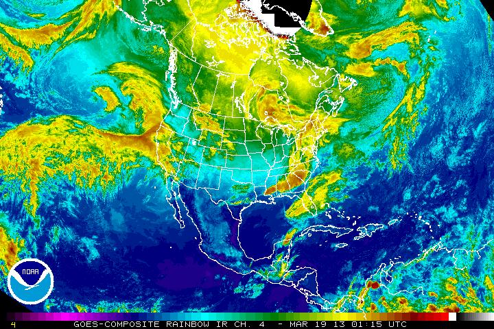
Big Pacific Storm merged with a Pinnaple Express one day ago
www.goes.noaa.gov
(visit the link for the full news article)
Just my observation...no news article yet.
I am mobile tonight so just the basic info no imbedded pics, etc.
There is a large storm poised off Northern California coast tonight. The reason my excitement is the bottom of the front touches the equator.
I have been saving NOAA images for the past 24 to prove it...tomorrow I can imbedded them here.
If this storm low pressure goes into cutoff low mode (goes South), then the whole system will cause a lot of rain in all of California.
About 15% of winter storms become cutoff lows by my knowledge.
The next few hours will decide the path...upper jet stream or cutoff low?
Anyone who wants to post any pics tonight is welcome too and I will thank you in advance
www.goes.noaa.gov
(visit the link for the full news article)
reply to post by Granite
Here you go. I know you have more, but I can at least post the one you have on the link.

Mobile posting is frustrating, I know. Sometimes it pays just to wait until you are on a desktop
If you want to edit your post and put it in yourself, use (pic)hi5147cb2c.jpg(/pic) but replace my parenthesis with brackets, if you can and want to.
Here you go. I know you have more, but I can at least post the one you have on the link.

Mobile posting is frustrating, I know. Sometimes it pays just to wait until you are on a desktop
If you want to edit your post and put it in yourself, use (pic)hi5147cb2c.jpg(/pic) but replace my parenthesis with brackets, if you can and want to.
edit on 18-3-2013 by Twix404 because: (no reason given)
new topics
top topics
-
Marvin Gabrion's sentence commuted by Biden
US Political Madness: 14 hours ago, 14 flags -
London Christmas Market BANS Word ‘Christmas’
Social Issues and Civil Unrest: 14 hours ago, 12 flags -
1 Billion dollars
General Entertainment: 12 hours ago, 6 flags -
Drones On Live Beach Cam New Jersey.
Aliens and UFOs: 17 hours ago, 4 flags -
Parker Solar Probe is about to Kiss the Sun
Space Exploration: 15 hours ago, 4 flags
3

