It looks like you're using an Ad Blocker.
Please white-list or disable AboveTopSecret.com in your ad-blocking tool.
Thank you.
Some features of ATS will be disabled while you continue to use an ad-blocker.
8
share:
OK guys, so I found something on the MSL Rocknest panorama that resembles the front
part of a ship!
Well, at least that was my first impression while probably suffering from pareidolia. Anyway, I couldn't believe nobody else noticed this or took any snapshots on GigaPan. But let's take a look at the images before going into the details:
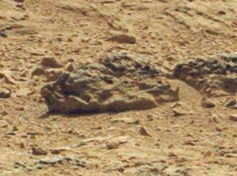
This is what caught my attention:
 So, to me, this looks as if it could have once been the front part of a ship. Note the triangular shapes, spikes or
"teeth" visible along the lower left part of that particular rock formation.
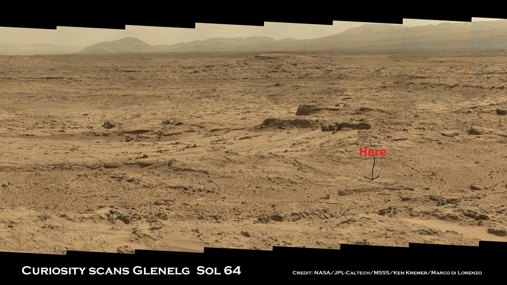
When zooming out and putting it into a larger context, you can see the following:

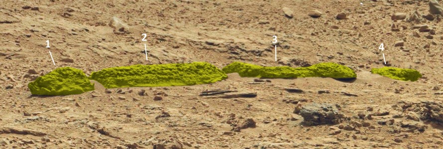
In the following image, I highlighted in yellow what seem to be the parts of a larger sedimentary layer or "structure":

Finally, here goes the link to the original Sol 64 image at NASA/JPL.
In my view, at least sections 1 and 2 seem to be related in some way or used to be connected at one time. In any case, all of these sections together form a peculiar geological feature, that I thought might be worth discussing here. I'm not a geologist, nor do I have any special insights into the natural forces that might have been at work on Mars, ultimately leaving behind such strange shapes.
I've been searching the web for some peculiar artifacts that were formed by erosion on earth and there's a lot of impressive stuff that looks symmetrical or artifical, but is - in fact - just natural. Yet, ever since I came across the images of Curiosity/MSL, I couldn't fight the feeling that there's just an awful lot of stuff out there (especially at Rocknest), which resembles metal brackets, hinges and other shapes with an overaverage amount of symmetry, right angles, near perfect circular perforations etc. I find this intriguing, especially since there seems to be more of it here than on any other images even from previous missions (eg. MER-A, MER-B etc.) and I've been following those with great interest all through the years - by the way, without noticing anything "unusual" on those images.
Finally, let me stress that I'm aware of the fact that we're looking at 50+ millions of rocks or so on each panorama and that the base at Mount Aeolis is an alluvial fan with lots of rubble having been exposed to erosion, meteors and seismic activity for millions of years. But to make a long story short: Inspite of "precise science" and data being the key to unravel the secrets of Mars, I still find those recent MSL images extremely peculiar and intuition keeps telling me: there might be more to it than our science data is revealing up to this point ...
So now it's time to hand this over to you, guys, what do you think we're dealing with here?
Well, at least that was my first impression while probably suffering from pareidolia. Anyway, I couldn't believe nobody else noticed this or took any snapshots on GigaPan. But let's take a look at the images before going into the details:
This is what caught my attention:

When zooming out and putting it into a larger context, you can see the following:

In the following image, I highlighted in yellow what seem to be the parts of a larger sedimentary layer or "structure":

Finally, here goes the link to the original Sol 64 image at NASA/JPL.
In my view, at least sections 1 and 2 seem to be related in some way or used to be connected at one time. In any case, all of these sections together form a peculiar geological feature, that I thought might be worth discussing here. I'm not a geologist, nor do I have any special insights into the natural forces that might have been at work on Mars, ultimately leaving behind such strange shapes.
I've been searching the web for some peculiar artifacts that were formed by erosion on earth and there's a lot of impressive stuff that looks symmetrical or artifical, but is - in fact - just natural. Yet, ever since I came across the images of Curiosity/MSL, I couldn't fight the feeling that there's just an awful lot of stuff out there (especially at Rocknest), which resembles metal brackets, hinges and other shapes with an overaverage amount of symmetry, right angles, near perfect circular perforations etc. I find this intriguing, especially since there seems to be more of it here than on any other images even from previous missions (eg. MER-A, MER-B etc.) and I've been following those with great interest all through the years - by the way, without noticing anything "unusual" on those images.
Finally, let me stress that I'm aware of the fact that we're looking at 50+ millions of rocks or so on each panorama and that the base at Mount Aeolis is an alluvial fan with lots of rubble having been exposed to erosion, meteors and seismic activity for millions of years. But to make a long story short: Inspite of "precise science" and data being the key to unravel the secrets of Mars, I still find those recent MSL images extremely peculiar and intuition keeps telling me: there might be more to it than our science data is revealing up to this point ...
So now it's time to hand this over to you, guys, what do you think we're dealing with here?
edit on 15-2-2013 by jeep3r because: Modified 'formatting'
The jagged shell-like dimensions of section 1 do appear like some sort of hull
What would happen to metal alloys in Mars' atmosphere chemistry and foreign body bombardment over thousands to millions of years?
What would happen to metal alloys in Mars' atmosphere chemistry and foreign body bombardment over thousands to millions of years?
You are non far away from the truth...
The surrounding terran around Curiosity if full of Fossils. So the "Rocknest" must becalled the "Bonenest".
Paleontologists need on Mars.
The surrounding terran around Curiosity if full of Fossils. So the "Rocknest" must becalled the "Bonenest".
Paleontologists need on Mars.
Originally posted by heyitsok
Oh. My. God.
Here's the full image , it doesn't look out of place among the other rock formations in my view .


it looks to me like a huge dead crokodial (martian spelling hahah)
doesn't it??
doesn't it??
There are Many Things about Mars and all of these recent photos that are interesting, But we will Never be told the Truth about Mars, or the Moon
which also has some Curious photos that have been posted on this site. T.P.T.B. only know the truth.
Originally posted by tropic
What would happen to metal alloys in Mars' atmosphere chemistry and foreign body bombardment over thousands to millions of years?
That's a good pointer and I have no idea what kind of construction material (alloys?) and/or natural circumstances would be needed to produce the result we see in those images over a period of thousands, hundreds of thousands or even millions of years.
Obviously, most of it - if not all - has indeed turned into stone, but the shapes seem to have been preserved. Perhaps similar to the process in fossils, where minerals - over time - fill in the emtpy spaces preserving the shape of an organism. In any case, it remains an interesting question (and a bizarre image)!
reply to post by jeep3r
I have a youtube video of what I believe to be a wreck. Also a picture of another much bigger. However, these do not surprise me now having seen what we have so far. No more proof needed for me. I am currently doing a video about pictures of a crashed alien spaceship. Here's my wreck video:
www.youtube.com...
Originally posted by MartianSoldier
reply to post by jeep3r
However, these do not surprise me now having seen what we have so far. No more proof needed for me.
Thanks for the reply and flagging, MartianSoldier!
I, too, think it's becoming increasingly difficult to explain everything away with 'rocks' (well, they are, sort of ... but then again 'not' ). There is simply too much visual evidence in such a small area and that - to me - suggests that we need to consider 'alternative' theories.
I could imagine that nature might produce one of those artifacts by accident, perhaps two or three but not that amount of geometrical shapes with common features as they are being referred to in so many threads here on ATS.
It's good to know, though, that I'm not the only one seeing such peculiar shapes in the martian landscape!
Thanks again & cheers!
I didn't know where to post this and didn't want to create a new thread. But perhaps it'll help this one to not get buried too deep in the ATS
archives!!
So just for those of you are curious about the more official updates from NASA/JPL:
NASA Hosts Teleconference Today About Curiosity Rover
Febuary 20 at noon PST (3 p.m. EST)
Might be boring, might be exciting, who knows. In any case, I'll try to watch it on ustream.
Cheers!
So just for those of you are curious about the more official updates from NASA/JPL:
NASA Hosts Teleconference Today About Curiosity Rover
Febuary 20 at noon PST (3 p.m. EST)
Might be boring, might be exciting, who knows. In any case, I'll try to watch it on ustream.
Cheers!
new topics
-
'Mass Casualty event' - Attack at Christmas market in Germany
Mainstream News: 4 hours ago -
Search to Resume for MH 370
Disaster Conspiracies: 7 hours ago -
Sue Gray, Sir Keir Starmer's former Chief of Staff, Nominated for Peerage
Regional Politics: 8 hours ago -
Biden Nationalizes Another 50,000+ Student Loans as He Heads for the Exit
US Political Madness: 9 hours ago
top topics
-
'Mass Casualty event' - Attack at Christmas market in Germany
Mainstream News: 4 hours ago, 22 flags -
Biden Nationalizes Another 50,000+ Student Loans as He Heads for the Exit
US Political Madness: 9 hours ago, 7 flags -
Search to Resume for MH 370
Disaster Conspiracies: 7 hours ago, 4 flags -
Sue Gray, Sir Keir Starmer's former Chief of Staff, Nominated for Peerage
Regional Politics: 8 hours ago, 3 flags
active topics
-
US Federal Funding set to Expire December 20th. Massive CR on the way.
Mainstream News • 56 • : DBCowboy -
'Mass Casualty event' - Attack at Christmas market in Germany
Mainstream News • 54 • : NorthOS -
My personal experiences and understanding of orbs
Aliens and UFOs • 22 • : Compendium -
Post A Funny (T&C Friendly) Pic Part IV: The LOL awakens!
General Chit Chat • 7935 • : KrustyKrab -
Search to Resume for MH 370
Disaster Conspiracies • 4 • : theatreboy -
Drone Shooting Arrest - Walmart Involved
Mainstream News • 38 • : bluesman023 -
Covid....... Again.
Diseases and Pandemics • 33 • : annonentity -
Biden Nationalizes Another 50,000+ Student Loans as He Heads for the Exit
US Political Madness • 8 • : xuenchen -
Russias War Against Religion in Ukraine
World War Three • 55 • : Freeborn -
Squirrels becoming predators
Fragile Earth • 36 • : ManSizedSquirrel
8

