It looks like you're using an Ad Blocker.
Please white-list or disable AboveTopSecret.com in your ad-blocking tool.
Thank you.
Some features of ATS will be disabled while you continue to use an ad-blocker.

The Black Hole in Russia
page: 1share:
It is almost eight years ago now that I was surfing around on google maps and found this odd blurred spot in far north eastern Russia. Attempts to
research why the images of this particular area which I would soon learn was called “Chukotka” all wound up in dead ends.
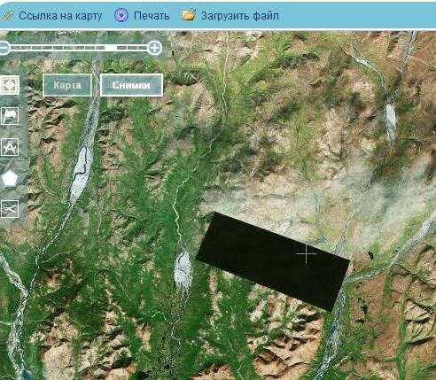
The place in question is located at: 66.266304,179.214478 on Google Maps.
Locati on
In fact, it was during some of my initial research that I first discovered the ATS forum (it would only take me 7 more years to join). At the time there had already been a thread posted here on ATS about it…so I guess I wasn’t the only one curious about the mysterious place.
Old thread
Over the years I’ve had more than a casual interest in any developments that might materialize about this area. I believe I’ve located virtually every website on the Internet that has any information about this area. Now, I know that sounds like a pretty tall tale, ‘every website on the Internet’, but I’m actually being serious. Oh sure, I’m sure I’ve missed some, but I’ve been to google forums, birding websites, travel websites, photo, military, oil exploration, mining, and even to Russian websites where I’ve had to translate (as best I can) researching the area. I can pretty safely say there is more information about the remotest places of Antarctica than there is about Chukotka. And, interestingly, most of the information about Chukotka that can be found is about one of three subjects…birds, a guy named Roman Abramovich or people researching the blurred spot.
One can find plenty of information about areas just north, and just south, of this area, but this particular location is like a black hole of nothingness. As it turns out, there have been people looking into the mysterious blurred spot going back even further than 2008 (I’ve found some early references to it in 2004 and earlier). The areas just north and south of this area were hotbeds of activity during the Cold War, but not this place.
My research has not been limited to just the Internet either. Working in aviation, airports and electronics we have some excellent access to satellite imagery and other resources. There too…I’ve found little to nothing.
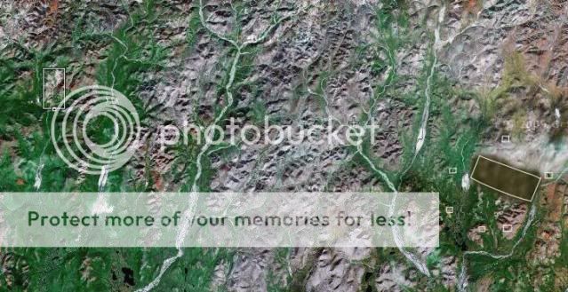
Here are some topographic images of the area in question
Image 1
Image 2
From the maps you can see the area is very remote indeed. Travel there would clearly be a challenge, if you could even get there to begin with. There are no roads, no infrastructure at all and rivers, bogs and tundra everywhere. However, as remote as the area looks there are areas of development. Just south of this area is one of the largest diamond mines on Earth (at one point it was the World’s largest), and just north and west of this area is a monstrous silver mining operation.
Now, I’ve read the many explanations about why this place in Chukotka is the anomaly that it is. Dropped satellite pixels and mismatched image overlap seem to be the most plausible theories…but on every available satellite known to man (American, Russian, Chinese, Japanese and even Israeli)? Really? How would this be possible? I’m sorry, I just cannot accept these as the reason. On some satellite images the location has been obviously altered, cloned or just shows nothing at all. There has been speculation about secret military installations, aliens and all manner of other bizarre things taking place under the blur, but no concrete explanation. Seems to me, whatever it is must have to do with money if it can affect so many imaging platforms.
I had hoped that as time passed since my first looking into the subject that developments would come along, that maybe the area would be re-imaged by satellites like most other areas, or that hopefully someone might come forward with a first-hand account, but no significant developments have come to light.
It is truly an enigma.
The place in question is located at: 66.266304,179.214478 on Google Maps.
Locati on
In fact, it was during some of my initial research that I first discovered the ATS forum (it would only take me 7 more years to join). At the time there had already been a thread posted here on ATS about it…so I guess I wasn’t the only one curious about the mysterious place.
Old thread
Over the years I’ve had more than a casual interest in any developments that might materialize about this area. I believe I’ve located virtually every website on the Internet that has any information about this area. Now, I know that sounds like a pretty tall tale, ‘every website on the Internet’, but I’m actually being serious. Oh sure, I’m sure I’ve missed some, but I’ve been to google forums, birding websites, travel websites, photo, military, oil exploration, mining, and even to Russian websites where I’ve had to translate (as best I can) researching the area. I can pretty safely say there is more information about the remotest places of Antarctica than there is about Chukotka. And, interestingly, most of the information about Chukotka that can be found is about one of three subjects…birds, a guy named Roman Abramovich or people researching the blurred spot.
One can find plenty of information about areas just north, and just south, of this area, but this particular location is like a black hole of nothingness. As it turns out, there have been people looking into the mysterious blurred spot going back even further than 2008 (I’ve found some early references to it in 2004 and earlier). The areas just north and south of this area were hotbeds of activity during the Cold War, but not this place.
My research has not been limited to just the Internet either. Working in aviation, airports and electronics we have some excellent access to satellite imagery and other resources. There too…I’ve found little to nothing.
Here are some topographic images of the area in question
Image 1
Image 2
From the maps you can see the area is very remote indeed. Travel there would clearly be a challenge, if you could even get there to begin with. There are no roads, no infrastructure at all and rivers, bogs and tundra everywhere. However, as remote as the area looks there are areas of development. Just south of this area is one of the largest diamond mines on Earth (at one point it was the World’s largest), and just north and west of this area is a monstrous silver mining operation.
Now, I’ve read the many explanations about why this place in Chukotka is the anomaly that it is. Dropped satellite pixels and mismatched image overlap seem to be the most plausible theories…but on every available satellite known to man (American, Russian, Chinese, Japanese and even Israeli)? Really? How would this be possible? I’m sorry, I just cannot accept these as the reason. On some satellite images the location has been obviously altered, cloned or just shows nothing at all. There has been speculation about secret military installations, aliens and all manner of other bizarre things taking place under the blur, but no concrete explanation. Seems to me, whatever it is must have to do with money if it can affect so many imaging platforms.
I had hoped that as time passed since my first looking into the subject that developments would come along, that maybe the area would be re-imaged by satellites like most other areas, or that hopefully someone might come forward with a first-hand account, but no significant developments have come to light.
It is truly an enigma.
edit on 2/13/2013 by Flyingclaydisk because: link problem
It is odd.
But the blur only seems to be on the latest image in Google Earth, not the earlier photos of the area.
Which is annoying, as the earlier images aren't very detailed.
But the blur only seems to be on the latest image in Google Earth, not the earlier photos of the area.
Which is annoying, as the earlier images aren't very detailed.
It's odd ... check this out .. mapquest has that area literally cut out ..
mapq.st...
Bing has the area but the map is so crappy in quality you can't see it
mapq.st...
Bing has the area but the map is so crappy in quality you can't see it
Originally posted by kimish
It's the Russian area 51
Actually, I don't think so. If you look at the topo maps and the satellite maps of the surrounding terrain the area is totally not condusive to any type of building. There are rivers and water everywhere, the terrain is arctic trundra, any civil engineering works there would be near impossible. Even traveling in the area would be next to impossible. You'd need some kind of a semi-amphibious tracked vehicle...which floated, to even get around. Plus, there doesn't appear to be a flat section of ground for a hundred miles in any direction, not to mention the fact that there are no roads, no rail lines, no power lines, literally no infrastructure at all leading into, or out of, this location.
Originally posted by miniatus
It's odd ... check this out .. mapquest has that area literally cut out ..
mapq.st...
Bing has the area but the map is so crappy in quality you can't see it
The mapquest map just screams of 'something here, but we can't show you!'.
The Bing map you refer to is one of the ones which has been altered. If you look carefully at it you will see an area just SW of the area in question which has been cloned over the the terrain in the mystery area. Look at the features, they're identical.
edit on 2/13/2013 by Flyingclaydisk because: added detail
nicely spotted let me say
but even if it is a military base so what
would that stop your curiosity?
say its the next diamond mine would you go there
and area 51 what then?
you see Russia is Russia no words can explain her
only a slight experience witch you wont forget or like.
so leave your mystery as it is a go an pursue it their your only option
doing research only create more questions hardly any answer will come out of them
reply to post by Flyingclaydisk
but on every available satellite known to man (American, Russian, Chinese, Japanese and even Israeli)?
How did you verify this..? IF you already stated how, I'm blind and please remind me.
a guy named Roman Abramovich
Plastic owner, Plastic Team...
Just wanted to add that.
but on every available satellite known to man (American, Russian, Chinese, Japanese and even Israeli)?
How did you verify this..? IF you already stated how, I'm blind and please remind me.
a guy named Roman Abramovich
Plastic owner, Plastic Team...
Just wanted to add that.
Here's an image from a Russian satellite...
Here's the Bing image. Notice the C&P line through it?

Here's another from a geographic terrain mapping satellite...
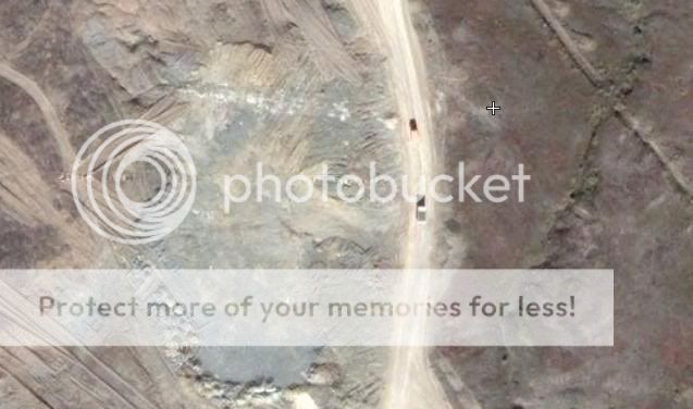
About 80km (40 miles) west of the area in question there is a gold / silver mine.
For reference it is the small white box on the left part of this image. You can also see the blurred area on the right side of the image.
This is the mine up close. Notice the resolution here?
In this image you can even see trucks running on the road.
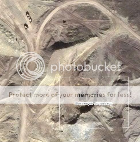
Same here, along with an excavator.
These images are all crystal clear and circa (2006). Now compare these to the very first image at a lower resolution. You can see that even the lower resolution view of the area has been blurred.
So, what I did next was to pan over to the east (towards the blur) to see how far I could get before the resolution changed. I get about half way (20 mi. or so).
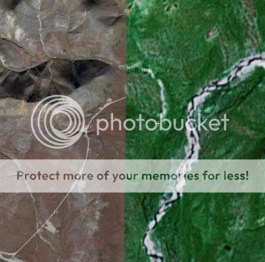
This is the image at the resolution break.
This last image is telling because it says a couple things. If you notice there is a road in the higher resolution (or left) side of the image. The road does not exist on the lower resolution (right) side suggesting the lower resolution side is an older image. However, why then does one blur out a section of an older, lower resolution, image?
Lastly, keep in mind most of the satellite images on the internet have only been made available in recent years. The images are digital images, not film photographs. To blur an image means it was smeared digitally (again, recently). Why?
Here's the Bing image. Notice the C&P line through it?
Here's another from a geographic terrain mapping satellite...
About 80km (40 miles) west of the area in question there is a gold / silver mine.
For reference it is the small white box on the left part of this image. You can also see the blurred area on the right side of the image.
This is the mine up close. Notice the resolution here?
In this image you can even see trucks running on the road.
Same here, along with an excavator.
These images are all crystal clear and circa (2006). Now compare these to the very first image at a lower resolution. You can see that even the lower resolution view of the area has been blurred.
So, what I did next was to pan over to the east (towards the blur) to see how far I could get before the resolution changed. I get about half way (20 mi. or so).
This is the image at the resolution break.
This last image is telling because it says a couple things. If you notice there is a road in the higher resolution (or left) side of the image. The road does not exist on the lower resolution (right) side suggesting the lower resolution side is an older image. However, why then does one blur out a section of an older, lower resolution, image?
Lastly, keep in mind most of the satellite images on the internet have only been made available in recent years. The images are digital images, not film photographs. To blur an image means it was smeared digitally (again, recently). Why?
Originally posted by facelift
reply to post by Flyingclaydisk
but on every available satellite known to man (American, Russian, Chinese, Japanese and even Israeli)?
How did you verify this..? IF you already stated how, I'm blind and please remind me.
No, perhaps that was a bit of an exaggeration, but I checked quite a few. I'm sure not all, but if you have more please do enlighten me! I'd love to evaluate them.
On any of the sites is there any speculation or theories as to what might be there?
It is curious that so many different mapping programs all have the same anomaly. You don't typically see collaboration on that level!
It is curious that so many different mapping programs all have the same anomaly. You don't typically see collaboration on that level!
reply to post by rimjaja
Theories I have seen on numerous websites run the gamut of possibilities. Everything from 'nothing at all' to 'something of worldly epic proportion', hence my undying desire to find out what, exactly the explanation is.
Theories I have seen on numerous websites run the gamut of possibilities. Everything from 'nothing at all' to 'something of worldly epic proportion', hence my undying desire to find out what, exactly the explanation is.
Entrance to Hades? No joke. Ever heard of that recording of Russians drilling down to hear the tectonic plates?
They heard millions of screaming people.
I also have a Russian step Aunty who 'KNOWS' that Hades and the Leader Gog is under the North of Russia. I asked her the question of Hades and she answered matter of factly, as if all Russians know that.
Tungunska was an ancient defence system to stop missles from outer space opening up Hades before its appointed time.
Which is what the Mayan calendar was all about; calculating the end of the prison time of the first occupants. The rest that joined them were not supposed to be there, and they will be coming out too.
reply to post by Flyingclaydisk
Have you tried GeoFuse? They seem to have an unblurred image--but I haven't studied the area as much as you have, so there might have been edits that aren't apparent to me.
GeoFuse link
Click the square button next to the Ikonos-2 listing in the search results, then make sure terrain is turned on in the map viewer.
Have you tried GeoFuse? They seem to have an unblurred image--but I haven't studied the area as much as you have, so there might have been edits that aren't apparent to me.
GeoFuse link
edit on 13-2-2013 by FurvusRexCaeli because: url
tag
Click the square button next to the Ikonos-2 listing in the search results, then make sure terrain is turned on in the map viewer.
edit on
13-2-2013 by FurvusRexCaeli because: (no reason given)
The area that supposedly contains the infamous Mel's Hole has similar censoring of areal images.
hideousmonster.com...
hideousmonster.com...
Could be an environmental blight they want to keep down low...
Since there are other mining operations in the area it might be something they want to keep secret from competitors? They aren't trying to keep it secret from government defense agencies for most of those have their own satellites.
You could go there, but I wouldn't advise it.
You could write the division of mining or whatever and ask to get employed there... see what kind of response you get.
If you knew, it would drive you insane. If you knew it would drive you mad...
Great thread op. This type of threads are the reason I joined ATS.. Which seem to be quite rare these days.. Don't really have much to add to
this mystery but just wanted to say that..
new topics
-
Nvm
General Chit Chat: 4 hours ago -
OK this is sad but very strange stuff
Paranormal Studies: 10 hours ago -
Islam And A Book Of Lies
Religion, Faith, And Theology: 11 hours ago
top topics
-
Sorry to disappoint you but...
US Political Madness: 14 hours ago, 13 flags -
OK this is sad but very strange stuff
Paranormal Studies: 10 hours ago, 7 flags -
Islam And A Book Of Lies
Religion, Faith, And Theology: 11 hours ago, 5 flags -
Nvm
General Chit Chat: 4 hours ago, 2 flags
active topics
-
Sorry to disappoint you but...
US Political Madness • 17 • : grey580 -
NJ Drones tied to Tesla explosion at Trump Las vegas
General Conspiracies • 55 • : Xtrozero -
Nvm
General Chit Chat • 2 • : grey580 -
Joe Biden gives the USA's Highest Civilian Honor Award to Hillary Clinton and George Soros.
US Political Madness • 50 • : Xtrozero -
-@TH3WH17ERABB17- -Q- ---TIME TO SHOW THE WORLD--- -Part- --44--
Dissecting Disinformation • 3947 • : Crazierfox -
Here we again... CHINA having mass outbreak of something
Diseases and Pandemics • 29 • : BeyondKnowledge3 -
Matthew Livelsberger said he was being followed by FBI
Political Conspiracies • 73 • : 38181 -
Islam And A Book Of Lies
Religion, Faith, And Theology • 5 • : BeyondKnowledge3 -
OK this is sad but very strange stuff
Paranormal Studies • 4 • : chiefsmom -
Musk calls on King Charles III to dissolve Parliament over Oldham sex grooming gangs
Mainstream News • 184 • : ufoorbhunter