It looks like you're using an Ad Blocker.
Please white-list or disable AboveTopSecret.com in your ad-blocking tool.
Thank you.
Some features of ATS will be disabled while you continue to use an ad-blocker.

Google Earth 'timeline' now only goes back as far as 2002?
page: 1share:
Anyone else experiencing this? Or is it just me?
And more specifically, in the Nevada Test Site region??
And more specifically, in the Nevada Test Site region??
It worked for me all the way back to 1937
edit on 29-12-2012 by Infi8nity because: (no reason given)
How far back you can view the timeline will depend on what areas are currently displayed... So for that particular spot, that is as far back as they
can go (have images for).
It depends on where you are. Some areas have older imagery than others.
Edit: Sek82 beat me to it...
Edit: Sek82 beat me to it...
edit on 29-12-2012 by SilentKoala because: (no reason given)
wow i didn't know this thanks for the share now that i really think about it ya it would!!!
reply to post by BobSacamano
We should probably prepare for the day that google decides not to store all the old imagery. It is a bit of a research project, but my understanding is there is a program that slowly moves the Google Earth view, which in turn puts the data in your cache. Then you archive the cache.
We should probably prepare for the day that google decides not to store all the old imagery. It is a bit of a research project, but my understanding is there is a program that slowly moves the Google Earth view, which in turn puts the data in your cache. Then you archive the cache.
I've able to 'rewind' the timeline all the way back to the 60's and 70's in the NTS area, in the past. I haven't fired up Google Earth in a
couple months, and get on today to see that it's capped at 10 years back (2002) in that region.
Kinda upset by this actually
*puts on tin foil hat* Maybe they're becoming wise that we were catching on to the apparent/totally obvious new construction and expansions that have been going on for the last 4 decades.. lol?
Kinda upset by this actually
*puts on tin foil hat* Maybe they're becoming wise that we were catching on to the apparent/totally obvious new construction and expansions that have been going on for the last 4 decades.. lol?
reply to post by gariac
There's no way you would be able to store that much data. Every single piece of imagery from every historical date from every location on the globe at every zoom level couldn't fit on all the hard drives at your local Fry's. That's why the data has to be streamed and isn't included as a standalone program.
There's no way you would be able to store that much data. Every single piece of imagery from every historical date from every location on the globe at every zoom level couldn't fit on all the hard drives at your local Fry's. That's why the data has to be streamed and isn't included as a standalone program.
reply to post by SilentKoala
I meant storing the data just for the Nevada Test and Training range, i.e. not storing everything Google has on GE. Certainly this would make sense for Groom Lake at the very least.
Sometimes the older data is clearer than the new data, or there were interesting aircraft on the ground in older imagery.
reply to post by gariac
That makes more sense. Funny you should mention GE and Groom Lake, I was just browsing around there for kicks earlier.
That makes more sense. Funny you should mention GE and Groom Lake, I was just browsing around there for kicks earlier.
reply to post by SilentKoala
In theory, Google determines where to buy new imagery based on where people look. So look at Groom Lake , the TTR, etc often. Here is a list of interesting spots:
TTR: 37°47'53.71"N 116°46'18.36"W
Base Camp: 38°18'39.77"N 116°16'43.96"W
Groom Lake: 37°14'14.26"N 115°48'27.61"W
Creech: 36°35'2.78"N 115°41'4.30"W (this is the Predator with shadow that Virtual Globetrotting found)
AOF: 36°55'37.48"N 116° 0'27.35"W
China Lake: 35°41'22.58"N 117°41'27.32"W
Honda test track (OK, not really spooky): 35°16'28.03"N 117°57'8.64"W
Kia Test track (ditto): 35° 3'32.65"N 118° 1'57.42"W
Edwards: 34°54'27.72"N 117°52'53.32"W
Mojave: 35° 3'8.03"N 118° 8'41.06"W
Tejon RCS (new imagery 2011): 34°55'39.27"N 118°31'56.69"W
(flying triangles at Tejon ;-) : 34°55'33.81"N 118°31'39.86"W and 34°55'31.66"N 118°31'38.41"W
General Atomics Gray Butte: 34°33'54.78"N 117°40'50.58"W
General Atomics El Mirage and El Mirage junk yard: 34°37'19.28"N 117°36'12.71"W
Helendale RCS (marker on new pad): 34°48'38.34"N 117°17'55.68"W
Originally posted by gariac
reply to post by SilentKoala
I meant storing the data just for the Nevada Test and Training range, i.e. not storing everything Google has on GE. Certainly this would make sense for Groom Lake at the very least.Sometimes the older data is clearer than the new data, or there were interesting aircraft on the ground in older imagery.
There IS "Google Earth Voyager (GEV)" for offline cache storage. I use it to store GE cache(s) to use offline when I am "down on the range" and don't have internet access. I guess myself or someone else should take the time to archive the NTTR. Never used it with the history tool though.
I see the historical images of Area 51 only go back to 6/6/2002 now. GE is acting very strangely tonight as well, a lot of lowres mosaic of sections of NTTR.
reply to post by FosterVS
37°13'46.34"N 115°48'38.95"W
This corner of the new hangar has been modified based on the time machine.
At one point in time, the southwest side of the new hangar was visible. There were what looked like electrical breaker boxes on it. That person that was doing the 3D modeling would know for sure.
The first images of Groom Lake were done in 2000 by the FAS. I don't think it is too weird that GE only starts at 2002. That is the imagery that is misaligned.
reply to post by gariac
I clearly remember GE displaying black and white 60's or 70's satellite imagery, in the timeline feature.
I'll look through my screenshots from over the years and try to verify that.
I clearly remember GE displaying black and white 60's or 70's satellite imagery, in the timeline feature.
I'll look through my screenshots from over the years and try to verify that.
reply to post by weavty1
Certainly not the 60s or 70s. There is an old Soviet B&W Groom Lake image, but it was never on Google Earth. The old B&W imagery on GE is from the USGS, and that didn't cover Groom Lake.
Certainly not the 60s or 70s. There is an old Soviet B&W Groom Lake image, but it was never on Google Earth. The old B&W imagery on GE is from the USGS, and that didn't cover Groom Lake.
The change to the corner of the new hangar can be seen in the above image. It is just a box of sorts sticking out at the corner. It doesn't go all the way to the ground.
I initially thought the black spot on the side of the building is a door, but looking at a few of the shots taken that day, I believe the black area is just a shadow.
Originally posted by gariac
reply to post by FosterVS
37°13'46.34"N 115°48'38.95"W
This corner of the new hangar has been modified based on the time machine. At one point in time, the southwest side of the new hangar was visible. There were what looked like electrical breaker boxes on it. That person that was doing the 3D modeling would know for sure. The first images of Groom Lake were done in 2000 by the FAS. I don't think it is too weird that GE only starts at 2002. That is the imagery that is misaligned.
I compiled a picture of the different images of that spot on GE. Almost looks to me like they added something to that corner of the building.
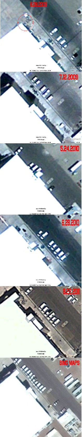
Higher res:
www.topsecretbases.com...
edit on 1-1-2013 by FosterVS because: (no reason given)
OT - speaking of the big "new" hangar - maybe you can address this gariac.
I have seen the "berm" aka large blocking pile-o-dirt on the east side of this hangar on the panorama's. I haven't seen this discussed, maybe I missed it, but I see more than this berm on the imagery. It appears to me that these berm(s) were placed to block viewing of this hangar from the runways i.e. Janet flights, and possibly other areas of the base, and weren't particularily placed to block the view from Tikaboo?
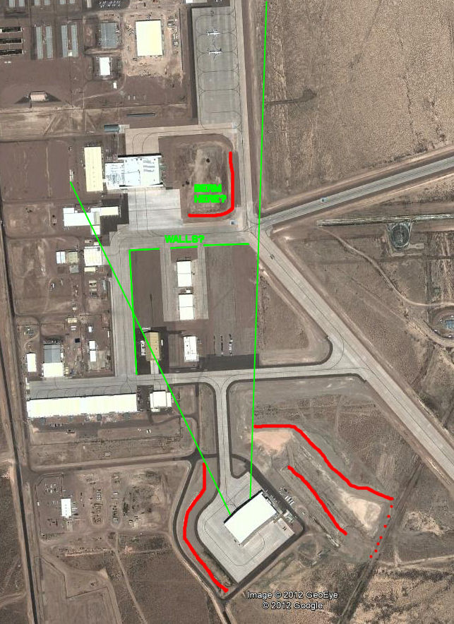
I have seen the "berm" aka large blocking pile-o-dirt on the east side of this hangar on the panorama's. I haven't seen this discussed, maybe I missed it, but I see more than this berm on the imagery. It appears to me that these berm(s) were placed to block viewing of this hangar from the runways i.e. Janet flights, and possibly other areas of the base, and weren't particularily placed to block the view from Tikaboo?
reply to post by FosterVS
You probably missed the image link.
I cranked up the contrast a bit more. It looks to me like a landing of some sort, then perhaps stairs to the ground. The solid part doesn't go all the way to the ground. It could be a fire escape or some sort of service access.
You probably missed the image link.
I cranked up the contrast a bit more. It looks to me like a landing of some sort, then perhaps stairs to the ground. The solid part doesn't go all the way to the ground. It could be a fire escape or some sort of service access.
reply to post by FosterVS
It looks to me like they have a small detention basin east of hangar 18.
37°14'8.45"N 115°48'43.60"W
So there could be a berm there where you indicated. I don't know enough about desert construction to comment with any authority, nor do I have a degree in CE. But I have paid for such engineering. In more "normal" places (as in not the desert), they put a detention basin to catch the dirt (silt) that is carried off with the water, then there is a drainage path to dump the water into a stream. [By retaining some water before allowing it to flow, it reduces the storm surge.] But in the desert, they just dig the basin and that is that. I assume they figure the water will just evaporate and/or flow into the ground.
They have a detention basin near the TTR "mancamp".
37°53'14.24"N 116°45'28.50"W
It is actually on the BLM property. To get to Mt. Diablo (which is just a small hill, not to be confused with California's 4000ft Mt. Diablo), you drive the edge of this detention basin.
When you grade for construction, you have to do something with the dirt. [Too bad the infamous nuclear tunnel bore machine that vaporizes dirt doesn't exist.] Whatever you do with the dirt, you can't leave it in a state where it will erode away. [Assuming Groom isn't using the "we don't need no stinkin' badges philosophy.] One solution is to fill a hole. The other is to pile the dirt with a 2:1 slope, which is very stable. [Think of the sands in an hour glass. It wasn't the Vulcan mind meld that made so many civilizations build pyramids.] Since that dirt pile doesn't accomplish much of anything, I think they just piled the dirt there because it was the cheapest disposal solution. The third choice is to off haul the dirt, which eats up a lot of diesel.
Though we don't have a view of the north side of the new hangar, it is pretty obvious there are doors on both sides. Most of the time, I assume they use the door we can't see from Tikaboo.
That berm isn't long enough to block much of the view from the runway. I suppose as a counter argument to the berm being used to block a view, we know the base does put up fences.
37°14'3.78"N 115°48'16.41"W
In the case of this structure, then blocked the Tikaboo view and the view from the base. In security, they often speak of TNO (trust no one).
new topics
-
Kamala Set A New Record
2024 Elections: 6 hours ago
top topics
-
Influx Of Migrants Just Doubled The Population Of A Small Ohio Town
Social Issues and Civil Unrest: 14 hours ago, 10 flags -
A new phase of evil brewing
General Conspiracies: 13 hours ago, 7 flags -
Of all things, grunge music. Short, simple, relevant, not NSFW.
Conspiracies in Religions: 12 hours ago, 5 flags -
Kamala Set A New Record
2024 Elections: 6 hours ago, 5 flags
active topics
-
BREAKING Israeli military says possibility' it has killed Hamas leader Yahya Sinwar
War On Terrorism • 65 • : jofafot -
Of all things, grunge music. Short, simple, relevant, not NSFW.
Conspiracies in Religions • 21 • : Solvedit -
Nearly one-third of Border Patrol’s cameras along the US-Mexico border ‘don’t work’
Social Issues and Civil Unrest • 6 • : Scratchpost -
Uk Govt sending staff and recruiting for people to campaign for Harris in the US
2024 Elections • 124 • : Oldcarpy2 -
Kamala Set A New Record
2024 Elections • 11 • : andy06shake -
25 illegal immigrants, 3 Disney employees 157 suspects arrested in human trafficking ring
Social Issues and Civil Unrest • 16 • : network dude -
Exhausted Donald has a Mic Malfunction
2024 Elections • 61 • : yeahright -
Euclid’s 208-Gigapixel glimpse into the Universe - Space is Big.
Space Exploration • 19 • : gortex -
The UN’s DARK Agenda: Agenda 2030
New World Order • 12 • : gortex -
We Now Know the Size of the Modern Gaming Audience - Sweet Baby Cries
Video Games • 7 • : gortex