It looks like you're using an Ad Blocker.
Please white-list or disable AboveTopSecret.com in your ad-blocking tool.
Thank you.
Some features of ATS will be disabled while you continue to use an ad-blocker.
share:
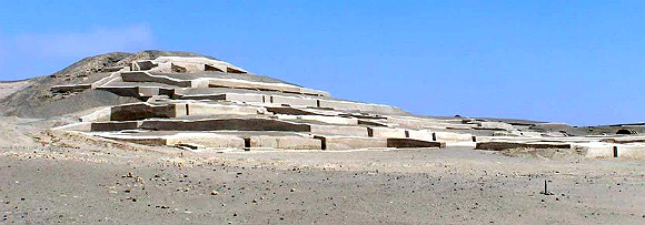
Hello
This time around I'd like to introduce those who have not yet heard of the Cahuachi culture to them and their amazing accomplishments. [not to be confused with the Paracas culture] Which I'll be writing another thread on later this month. Please allow me to take you on a virtual tour of this amazing Peruvian site. Be Advised: This site has everything. There we find Pyramids, Temples, Mummies, Elongated and Bulbous Skulls and of course the nearby NAZCA lines themselves.
This article The Lost City of Nasca posted a few years back got me interested in writing this thread to post some updated information on what has been uncovered. Let's begin with what is already known.
Cahuachi
Cahuachi, in Peru, was a major ceremonial center of the Nazca culture, based from 1 CE to about 500 CE in the coastal area of the Central Andes. It overlooked some of the Nazca lines. The Italian archaeologist Giuseppe Orefici has been excavating at the site for the past few decades . The site contains over 40 mounds topped with adobe structures. The huge architectural complex covers 0.6 sq. miles (1.5 km2). The American archeologist Helaine Silverman has also conducted long term, multi-stage research and written about the full context of Nazca society at Cahuachi, published in a lengthy study in 1993.
Scholars once thought the site was the capital of the Nazca state but have determined that the permanent population was quite small. They believe that it was a pilgrimage center, whose population increased greatly in relation to major ceremonial events. New research has suggested that 40 of the mounds were natural hills modified to appear as artificial constructions. Support for the pilgrimage theory comes from archaeological evidence of sparse population at Cahuachi, the spatial patterning of the site, and ethnographic evidence from the Virgin of Yauca pilgrimage in the nearby Ica Valley (Silverman 1994).
Looting is the greatest problem facing the site today. Most of the burial sites surrounding Cahuachi were not known until recently and are tempting targets for looters.
So, the site is presently thought to simply have been a ceremonial location. However, The more they dig the larger and more extensive and sophisticated the site appears to have been. Like many sites in Peru, Cahuachi and the surrounding area were used by various peoples down through the centuries. Which may have possibly muddied the waters so to speak as to it's true age, original purpose and to which peoples may have been the original inhabitants.
Archaeologists actually discovered the site a few decades ago.
At the time it really didn't look like much.
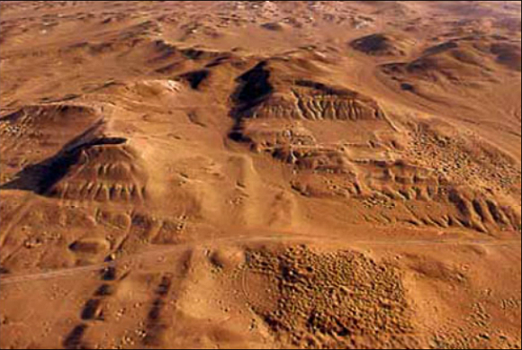
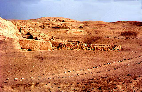
Since then the site they have uncovered has been come to be called as the lost city of the line-builders: Cahuachi. The site is on the Peruvian Pampa which lies 75 km inland from the coast of Peru and just south of the Nazca lines.
The site was supposedly started around 2000 years ago and abandoned 500 years later. There we find what we often find in Central and South America, the ancients either building one on top of the other or later cultures utilizing the sites for their own unrelated purposes. This is the repeated pattern in many of these ancient cultures. Often finding what appears to be more sophisticated and advanced designs at the lower much older levels.
What I find strange is that the prevailing theory is the site was destroyed and possibly abandoned because of a combination of Earthquakes which is common to the area and a massive flood. Now, how one has a massive flood in such a dry location at this altitude is beyond me. The area in question is very dry but bizarrely the remnant ruins show what appears to be water erosion. Two things pop into question. 1. When did the last major environment change occur and 2. Just exactly how possibly old is this site? Here are couple of renditions of what the whole site may have looked like at it's height.
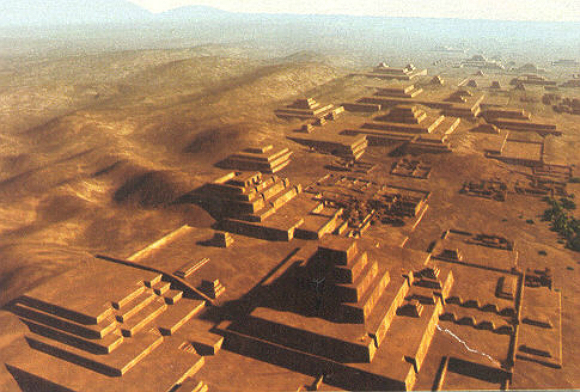
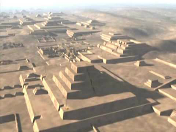
I thought I'd post this video which should give an idea of how it once looked. I have a feeling that Peru will eventually prove to be and become much more important as time goes by as more and more locations come to light and are extensively explored and understood.
There is no denial that the site and much of the surrounding area had been used continuously for burying the dead. The environment is perfect for preserving their bodies. I find the site a bit puzzling and I ask has the site always been used as such from the beginning or was it the later follow on cultures which began to use it as such? In other words were these mummies from the original builders and was that the locations original purpose?

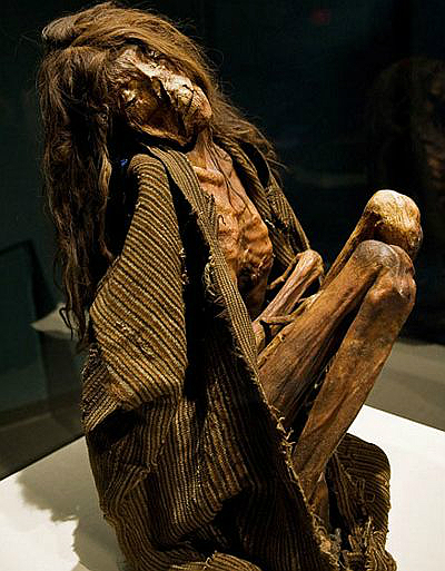
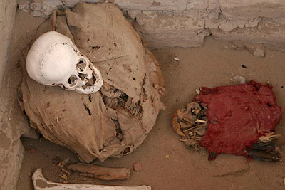
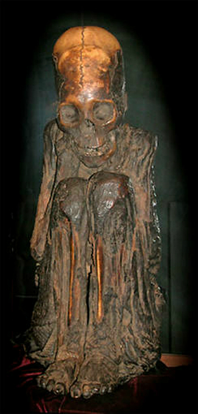
Hopefully not too many will be disappointed in this NAZCA related thread with no images of the lines. I figured those have been posted numerous times over the years. I thought a thread on the lesser known aspects and people of the area would be an interesting and refreshing change.
I'll post updates as more of the site is explored and excavated.
As always stay tuned.
edit on 13-12-2012 by SLAYER69 because: (no reason given)
Thank you for this thread, personally I am not to familiar with NAZCA and the Cahuachi
Going to be a great and informative read I'm sure.
SS
Going to be a great and informative read I'm sure.
SS
reply to post by Spike Spiegle
FYI:
I need to explain to those who have read it when I first posted. I still had some remaining paragraphs and information left on my clip board which I have just now edited and pasted them where they belonged.
Sorry about the premature posting guys.
Too much coffee
FYI:
I need to explain to those who have read it when I first posted. I still had some remaining paragraphs and information left on my clip board which I have just now edited and pasted them where they belonged.
Sorry about the premature posting guys.
Too much coffee
Nice thread slayer
[off topic] I found a PDF on Olmec art. It is over 200 pages and it is very interesting. As I read through it I thought of you.
[on topic] As always, GREAT THREAD S&F. I wish they would have put a little more color into those rendition photos. I doubt if it was all desert at the time it was built.
Quad
edit on 13-12-2012 by Quadrivium because: changed threat to thread
Thank you again for another awesome thread Slayer!
Nazca!
S + F to you!
They had a thing for them lines and chopping people's heads off no?
I always find it interesting how the Precolumbian south American Civilizations always seem to be the most ritualistically blood thirsty in comparison to many of the other historical and prehistorical cultures around the globe.
Nice job as always,slayer.
The Nazca Lines and the people associated with making those marking has always fascinated me.
There was a new study and theory behind those massive,intricate lines.
antiquity.ac.uk...
Now,that is the paper written on this study.
You have to pay them to read the rest.
So,I will link you to some that did pay them to gain access.
www.sciencenews.org...
The Nazca Lines and the people associated with making those marking has always fascinated me.
There was a new study and theory behind those massive,intricate lines.
Desert labyrinth: lines, landscape and meaning at Nazca, Peru
The shapes drawn out by the famous Nazca lines in the Peruvian desert are at their most evident from the air—giving rise to some famously fantastic theories about their origin. The new understanding offered here is the result of a piece of straightforward brilliance on the part of our authors: get down on the ground, where the original users were, and see where your feet lead you. Using stratigraphic and taphonomic reasoning to decide which lines were contemporary, they discover an itinerary so complex they can justify calling it a labyrinth, and see it as serving ceremonial progressions.
antiquity.ac.uk...
Now,that is the paper written on this study.
You have to pay them to read the rest.
So,I will link you to some that did pay them to gain access.
Archaeoastronomer Clive Ruggles of the University of Leicester in England discovered the labyrinth — a single path leading to and from an earthen mound, with a series of disorienting twists and turns along its flat, 4.4-kilometer-long course — by walking it himself. From the ground, little of the labyrinth is visible, even while ambling through it. From the air, it’s difficult to recognize the array of landscape lines as a connected entity. In the December Antiquity, Ruggles and archaeologist Nicholas Saunders of the University of Bristol in England describe and map what they regard as a carefully planned labyrinth from the ancient Nazca (sometimes spelled Nasca) culture. Nazca civilization flourished in southern coastal Peru from around 2,100 to 1,300 years ago. “This labyrinth was meant to be walked, not seen,” Ruggles says. “The element of surprise was crucial to the experience of Nazca labyrinth walking.”
www.sciencenews.org...
reply to post by Quadrivium
Oh man, I could spend all day talking about my various outside the box theories on the Olmec. That's a culture I'm going to revisit and soon as a topic of a thread.
Stay tuned.
Oh man, I could spend all day talking about my various outside the box theories on the Olmec. That's a culture I'm going to revisit and soon as a topic of a thread.
Stay tuned.
reply to post by Druscilla
This view of ritualistic blood letting and sacrifice may have been blown out of proportion. Don't get me wrong, there was plenty of that going on to varying degrees among many but not all New world cultures and civilizations had those types of rituals.
This view of ritualistic blood letting and sacrifice may have been blown out of proportion. Don't get me wrong, there was plenty of that going on to varying degrees among many but not all New world cultures and civilizations had those types of rituals.
reply to post by SLAYER69
Once again Slayer, you take the time to do a thread right.
My opinion, Mummy's are always strange, and spiritual to look at. I know with many cultures it was a higher spiritual plane they were journeying on. To have a glimpse on what they wore, where they were entombed, how they were preserved is actually as close as we can get to their own spiritual journey.
Very nice thread indeed.
Originally posted by Quadrivium
As always, GREAT THREAD S&F. I wish they would have put a little more color into those rendition photos. I doubt if it was all desert at the time it was built.
That actually a great question. How long ago did the environment change? Would that account for what appears to be moisture related erosion and damage. Also does that event jive with the accepted given age of the site?
edit on 13-12-2012 by SLAYER69 because: (no reason given)
reply to post by SLAYER69
Is it just me or does peering back into history seeing the physical evidence of it such as mummies and artifacts and ruins just give you goosebumps? Something about our history instinctively seems so amazing and profound to me yet I have no clue exactly why...
Its almost a nostalgic feeling when I imagine in my head what it would have actually been like to walk through these amazing cities seeing them at their prime and pristine condition...the clothes, the smells, the sounds...all of it has a sense of nostalgia when I imagine it...
Something about our ancient times seems so incredibly important and amazing...the story of our history seems as if it has to be more epic than what you will get from the traditional dry history lectures where apparently all the ancients did was trade, make pottery, war, and occasionally build a world wonder that even time fears...
Maybe I am a dreamer and wish the epic version to be real and the dry version to be a lie...
thanks for a great thread!!
SnF
edit on 13-12-2012 by Sly1one because: (no reason given)
reply to post by Sly1one
I've been drawn to ancient sites ever since I was a young boy visiting the local of Natural history Museum. There I saw a scale model of an elaborately sophisticated Pyramid complex under construction with what appeared even then to my young eyes as out of place workers using wooden ladders and carrying rocks in baskets ad laborers...
Just seemed out of place but I was hooked and since then I've read everything I could over the decades and explored many theories from Ancient Aliens, the slow steady progression of development and remnant lost cultures and civilizations.
The idea of lost cultures and civilizations is no longer being considered fringe science as it once was. Now that more and more sites are being discovered. I still say there are submerged even older sites along those ice age coast lines yet to be discovered and explored
reply to post by SLAYER69
fascinating. especially the last two photographs you posted. the skulls do not look human at all. the next to last skull has a distinct shape that doesn't seem to be the product of head binding, and the last skull, even if a binding was used to elongate it, has very large eye sockets.
from everything you've read, was there anything to suggest that they may not be human, or not completely human?
reply to post by Bob Sholtz
Yup many early cultures around the globe had a fascination with head deformations.
I wonder if they were trying to emulate somebody or something they saw?
Yup many early cultures around the globe had a fascination with head deformations.
I wonder if they were trying to emulate somebody or something they saw?
Great stuff. I was in Peru in '07 and loved it. It was a dream come true for me to go to Machu Picchu and Nazca as i've always wanted to go there
since I was a young. I think I may have gone to the same mummy museum as featured in one of your pics there. Here's a few more pics of the mummies
they found in that area.
I've got more but my work proxy doesn't seem to enjoy the ATS uploader for some reason!
Enjoy.
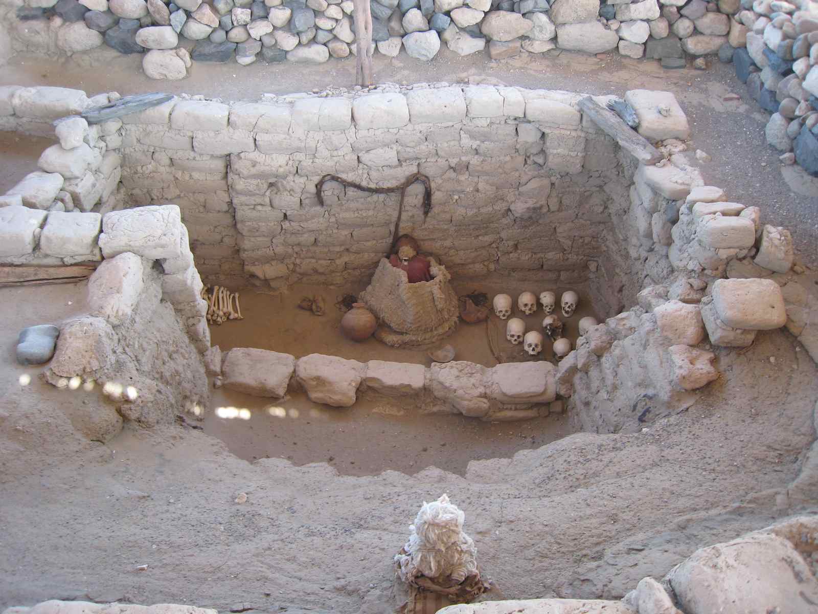
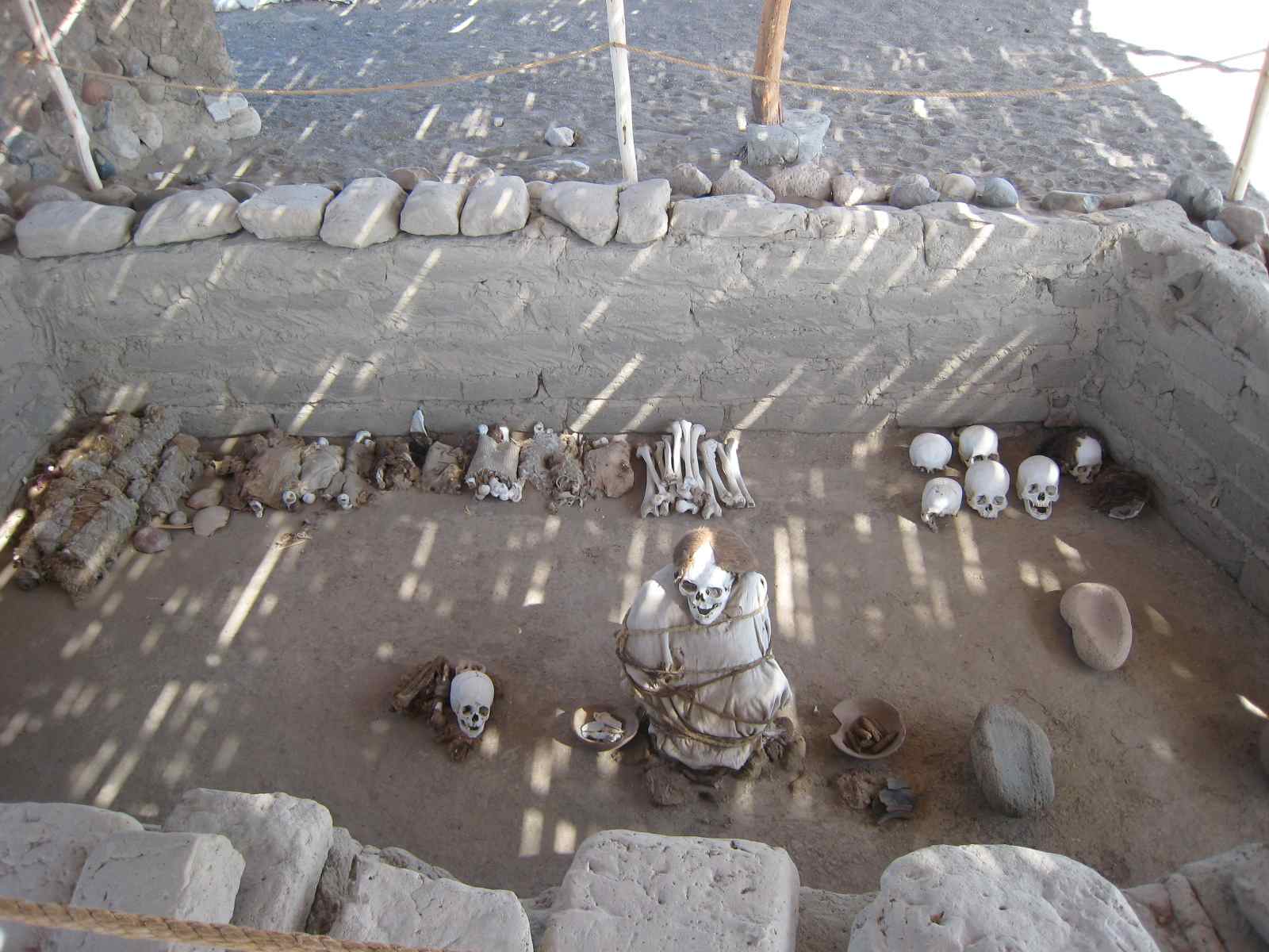
I've got more but my work proxy doesn't seem to enjoy the ATS uploader for some reason!
Enjoy.


reply to post by SLAYER69
i just did a bit of research, and i ran into an article showcasing some of the stranger skull shapes, and affirming they were not created by artificial means. the brain cavities are much larger than a human's, the eyes are larger, and one shows evidence that the optic nerve went through the bottom of the socket, not the center.
perhaps you may want to read it and take some of the photos along with their descriptions and add them on to the op.
www.cultcase.com...
what interests me the most is the second to last skull you posted. that shape is not achievable through modification, and the volume of the brain that occupied it far exceeds the maximum human size.
comparing normal human skull sutures to the elongated skulls is enough to question whether they were actually human. note on the last skull, it has a sagittal suture that runs from the front of the forehead all the way back. humans DO NOT HAVE THAT. our sagittal suture connects to the coronal (behind the forehead, almost mid skull) suture and runs back. it simply does not run down the forehead.
edit on 14-12-2012 by Bob Sholtz because: (no reason given)
Nice thread! Loved the visuals. I've seen a few documentaries on these people in the past. Very intriguing stuff.
While reading this thread, though, I had a thought...why is it that almost every time we see complexes like this, they are found in some of the most inhospitable places on the planet? Whether it be in jungle so dense a person literally has to hack their way into them with a machete, or in an arid desert, almost each and every megalithic building on the planet, that is still in tact (I'm discounting Roman and Greek architecture because they're basically in ruins now), we find them in places like this...
I could speculate on it all day. I also find the water erosion evidence at this site very interesting. Hints of Giza...another desert site...
reply to post by JayinAR
Great point.
I'm not going to argue the age of the Sphinx in this thread but just to use it as an example of how some believe these sites show signs of "Weathering patterns" that's not consistent with the present local environments where they are found.
We find moisture related weathering in presently very dry areas. This site has mud brick construction but we find them all muddled down from what appears to be either floods or heavy downpours. When was the last time this location was known to have heavy consistent downpours?
It's often explained that once upon a time thousands of years ago the locations were much more humid and damp. I get a chuckle sometimes because those dates are usually thousands of year before these sites supposedly existed...
new topics
-
Orbs Appear And Form Triangle On Live Cam.
Aliens and UFOs: 1 hours ago -
Biden Has New Bizarre Injuries to His Face
Politicians & People: 3 hours ago -
Something is not adding up in regards to the H-1B commotion
General Conspiracies: 3 hours ago -
Elon Musk Calls for Tommy Robinson to be Freed - and Takes a Dig at Starmer
Politicians & People: 4 hours ago -
Biden to award Presidential Citizens Medal to Liz Cheney and Bennie Thompson
US Political Madness: 4 hours ago -
Just learned a really helpful trick for internet searches
Computer Help: 10 hours ago
top topics
-
Biden Has New Bizarre Injuries to His Face
Politicians & People: 3 hours ago, 9 flags -
Just learned a really helpful trick for internet searches
Computer Help: 10 hours ago, 7 flags -
Biden to award Presidential Citizens Medal to Liz Cheney and Bennie Thompson
US Political Madness: 4 hours ago, 7 flags -
Not off to a good start
General Chit Chat: 12 hours ago, 6 flags -
Elon Musk Calls for Tommy Robinson to be Freed - and Takes a Dig at Starmer
Politicians & People: 4 hours ago, 5 flags -
Something is not adding up in regards to the H-1B commotion
General Conspiracies: 3 hours ago, 5 flags -
Orbs Appear And Form Triangle On Live Cam.
Aliens and UFOs: 1 hours ago, 3 flags
active topics
-
Tesla Cybertruck Explodes in Front of Trump Hotel in Las Vegas
Mainstream News • 110 • : Flyingclaydisk -
-@TH3WH17ERABB17- -Q- ---TIME TO SHOW THE WORLD--- -Part- --44--
Dissecting Disinformation • 3895 • : IndieA -
Vehicle Strikes people in New Orleans
Mainstream News • 270 • : BeyondKnowledge3 -
Strange fog all over the northern hemisphere
General Conspiracies • 43 • : annonentity -
The Acronym Game .. Pt.4
General Chit Chat • 1033 • : tinkerbell99 -
Ukraine halts transit of Russian gas to Europe after a prewar deal expired
Political Conspiracies • 111 • : Oldcarpy2 -
Post A Funny (T&C Friendly) Pic Part IV: The LOL awakens!
General Chit Chat • 7979 • : chiefsmom -
Biden Has New Bizarre Injuries to His Face
Politicians & People • 9 • : CarlLaFong -
If they can see...they can read!!
Rant • 28 • : AlroyFarms -
Biden to award Presidential Citizens Medal to Liz Cheney and Bennie Thompson
US Political Madness • 12 • : DAVID64
