It looks like you're using an Ad Blocker.
Please white-list or disable AboveTopSecret.com in your ad-blocking tool.
Thank you.
Some features of ATS will be disabled while you continue to use an ad-blocker.
share:
reply to post by PurpleChiten
I have some fond memories of Morehead when I was in college. (I went to Ohio University but we always went to Morehead on weekends to party).
Chairs must match. No exceptions. we Kentuckians already have the reputation of being trashy and hillbilly.
My facebook is blowing up to. It will be interesting. Someone already posted that mother earth is mad and made it political.
I love this land and the crazy people in it.
THey had a 2.5 aftershock a few minutes ago. I am wondering how the mines hold up with this? Is that a concern? I mean structural damage above ground
is nada,but, isnt it more intense under the earth?
wonder how many aftershocks they will get?
I didnt feel the aftershock. It was too deep and I am too far away.
wonder how many aftershocks they will get?
I didnt feel the aftershock. It was too deep and I am too far away.
reply to post by sueloujo
digital dyslexia maybe or do you think Reuters know something?!?
4.3 mb. 4.2 Mw which means the mb value must be out as 4.3 mb = ~4.8 Mw
digital dyslexia maybe or do you think Reuters know something?!?
4.3 mb. 4.2 Mw which means the mb value must be out as 4.3 mb = ~4.8 Mw
reply to post by tnhiker
You get more for your money with RSOE. Sounds about par for the course for them.
RSOE is showing two 4.3's, an hour apart and in separate locations.
You get more for your money with RSOE. Sounds about par for the course for them.
A little itty bitty one. Like a train going past your house.
Relax.
Relax.
I am in NE Knoxville, Felt it here as well. Rather interesting...
I have just done a lttle bit of research and i dont know whether i have made a connection or not, The epicenter of the shallow, light earthquake was
0.7 miles deep under the Appalachian Mountains town of Blackey, near the Virginia border, I have found an article that states 'Surface mining in the
Appalachian Mountains is polluting waterways and killing wildlife' dated October 16th of this year, i wonder if the surface mining had anything to do
with this quake(?)..
Here is the link for the article:
www.nature.com...
Here is the link for the article:
www.nature.com...
reply to post by rokkiroo
Very interesting find! Can mining cause earthquakes? Not trying to sound totally dumb, but, I really don't know.
And what is the difference between mining and surface mining:?
I also wonder if the quake affected the mines in the area...
Very interesting find! Can mining cause earthquakes? Not trying to sound totally dumb, but, I really don't know.
And what is the difference between mining and surface mining:?
I also wonder if the quake affected the mines in the area...
I have found an article on the USGS website that lists state-by-state mining regions:
'Significant sources of seismic events that are listed in "Routine Mining Seismicity in the United States," its predecessor "Probable Mining Explosions in the United States," or in earthquake catalogs of the USGS/NEIC.'
Kentucky is on the list, I'm certaintly no geologist and dont know what to make of this?
LINK: earthquake.usgs.gov...
reply to post by pacifier2012
said the dude on the fault line that always shakes... haha.. we had 3 earthquakes here about a year ago or so and let me tell you.. we people in the heartland still talk about it like it was the big one.. lol I can still point out the cracks in my house from the shifting.. if your in an area that is not used to earthquakes then it's a big dealio no matter what size.. i lived in alaska so i know what a true earthquake feels like.. ( it's like standing on a boat... ) the earthquakes here were nothing like that... you don't fell the earth shift so much as it's more stable.. i don't know how else to describe it.. but you don't feel a threat you just feel like " what the hell was that?" shake... and if you'll notice the earthquake watch... alot of little tremors are felt around the country... i don't think it's do to mining in any one area or what have you.. it's normal shifting of course if your in an area that doesn't normally get big enough ones to feel ... and then you do you want to have a reason.. when the reason is it happens all the time. you just don't feel it.
said the dude on the fault line that always shakes... haha.. we had 3 earthquakes here about a year ago or so and let me tell you.. we people in the heartland still talk about it like it was the big one.. lol I can still point out the cracks in my house from the shifting.. if your in an area that is not used to earthquakes then it's a big dealio no matter what size.. i lived in alaska so i know what a true earthquake feels like.. ( it's like standing on a boat... ) the earthquakes here were nothing like that... you don't fell the earth shift so much as it's more stable.. i don't know how else to describe it.. but you don't feel a threat you just feel like " what the hell was that?" shake... and if you'll notice the earthquake watch... alot of little tremors are felt around the country... i don't think it's do to mining in any one area or what have you.. it's normal shifting of course if your in an area that doesn't normally get big enough ones to feel ... and then you do you want to have a reason.. when the reason is it happens all the time. you just don't feel it.
I live in Morristown, Tn which is approximately 30 east of Knoxville and felt it here. I thought the washer was off balance at 1st but it got a bit
stronger than that. glasses clinked in the cabinet, windows rattled, and one picture that was not very well hung fell. The picture has been known to
fall when walking by it though so ts no big deal.
It seemed to last about 15 seconds. It was the 1st one I have felt and actually realized what it was when it was going on.
It seemed to last about 15 seconds. It was the 1st one I have felt and actually realized what it was when it was going on.
Originally posted by pacifier2012
A little itty bitty one. Like a train going past your house.
Relax.
I do not believe anyone is panicked. It as just an odd occurrence in our neck of the woods. I have been in a 7.1 so I know what a REAL earthquake feels like. I just never expected one to happen here in the central US.
We are lucky that the area is pretty rural and sparsely populated. If we were living on top of each other like out west it could've and would've been a lot worse.
~Peace
reply to post by k21968
Mining is below ground, surface mining is what you may know better as strip mining, open cast mining or open pit mining. It also includes mountain top removal.
Both mining and surface mining could cause seismicity, and I would imagine that surface mining causes seismicity due the the removal of the overburden and the mineral bearing layer. When you remove a mountain top you remove a lot o weight. I believe Kentucky has one or two area that have been reclaimed after mountain top removal.
reply to post by PuterMan
Here in Eastern Kentucky/West Virgina, there are actual mines where you ride down the shaft, dig out the coal and take it to the surface. There's some strip mining that goes on as well, but a LOT of regular mining as well.
That's what the Appalachians are known for.
Here in Eastern Kentucky/West Virgina, there are actual mines where you ride down the shaft, dig out the coal and take it to the surface. There's some strip mining that goes on as well, but a LOT of regular mining as well.
That's what the Appalachians are known for.
Well, Puterman beat me to it, but here's some info for ya'lls perusal.
reply to post by rokkiroo
 Per Wikipedia:
Now,to my mind, how stable is the "overburden replaced back on the ridge" is the question of the day!!??
If you enter the USGS GPS co-ordinates into Google maps you'll spy a "surface mine" just north east of the original 4.3 quake. In the map below the green arrows are the quake's co-ord; the google bulbs popped up w/ the co-ord - (I don't know how to remove them) Scroll the pic bar and you'll see the GPS co-ord on the map legend.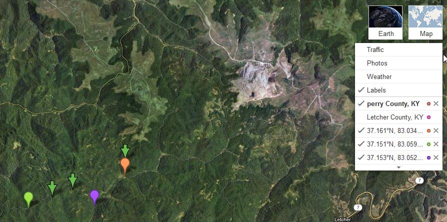
Now, they've been doing this type of mining for some time now unfortunately (explore google maps in this area -- WoW -especially past the ridge line to the SE!). And I don't know how old the Sat pics are in Google, could be they've extended the mining area??
So with all that surface mining going on, to my knowledge the blasting doesn't usually pop up as a quake, so I would assume?? these quakes aren't from blasting, but are the real deal from mother nature, and not so much cause and effect from the surface mining blasting, especially at 19.9 km/12.3 miles deep (the 4.3). But what Puterman said makes sense; kinda like glacial rebounding if you will.
The KY Mine Mapping Information System seems to be unavailable at this time (hmm.....how convenient) so can't tell if there are any "underground" coal mines in the immediate vicinity. I'm sure we would have heard something in the MSM if one had collapsed on miners.
All bets are off though if they've figured out how to frack coal in order to liquify it
What has my eyebrows raised is the sweet little arc connecting the dots on the USGS map: The big one in Guatemala, the one this am in Mobile Bay, the three in KY today and the ones in Canada. The ones in Canada happen quite often; Guatemala was a biggie; there has been one in Mobile Bay before, but it is an odd duck; and the Appalachians always have a lot of smallish ones. So is mama Earth feeling her wheaties and flexing her muscles or is she just stretching her bones before rolling over and going back to sleep or what??
Oh hell, as I was researching this the 7.0 in Myanmar just went off.......Guess mama earth is working on her second bowl of wheaties there.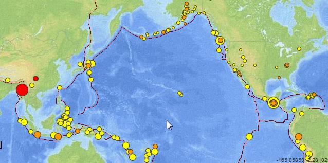
Peace to all
reply to post by rokkiroo
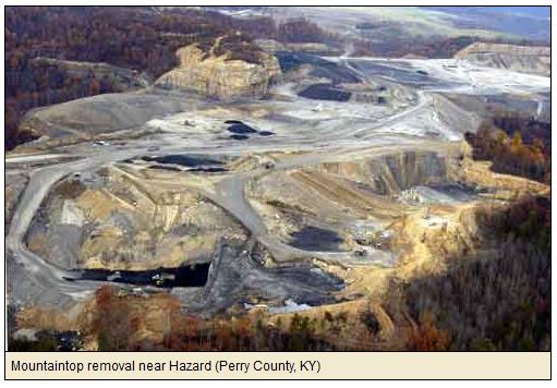
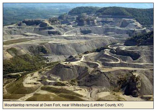
Can you say "mountain top removal"? Via these pics from Mountain Road Show in the same counties where quakes happened; 1st one (4.3) originated in Letcher County, 2 subsequent ones trending south west in Perry County.
'Surface mining in the Appalachian Mountains is polluting waterways and killing wildlife'


Mountaintop removal mining (MTR), also known as mountaintop mining (MTM), is a form of surface mining that involves the mining of the summit or summit ridge of a mountain. Entire coal seams are removed from the top of a mountain, hill or ridge by removing the overburden above them, and replacing the overburden back on the ridge to reflect the approximate original contour of the mountain
Now,to my mind, how stable is the "overburden replaced back on the ridge" is the question of the day!!??
If you enter the USGS GPS co-ordinates into Google maps you'll spy a "surface mine" just north east of the original 4.3 quake. In the map below the green arrows are the quake's co-ord; the google bulbs popped up w/ the co-ord - (I don't know how to remove them) Scroll the pic bar and you'll see the GPS co-ord on the map legend.

Now, they've been doing this type of mining for some time now unfortunately (explore google maps in this area -- WoW -especially past the ridge line to the SE!). And I don't know how old the Sat pics are in Google, could be they've extended the mining area??
So with all that surface mining going on, to my knowledge the blasting doesn't usually pop up as a quake, so I would assume?? these quakes aren't from blasting, but are the real deal from mother nature, and not so much cause and effect from the surface mining blasting, especially at 19.9 km/12.3 miles deep (the 4.3). But what Puterman said makes sense; kinda like glacial rebounding if you will.
The KY Mine Mapping Information System seems to be unavailable at this time (hmm.....how convenient) so can't tell if there are any "underground" coal mines in the immediate vicinity. I'm sure we would have heard something in the MSM if one had collapsed on miners.
All bets are off though if they've figured out how to frack coal in order to liquify it
What has my eyebrows raised is the sweet little arc connecting the dots on the USGS map: The big one in Guatemala, the one this am in Mobile Bay, the three in KY today and the ones in Canada. The ones in Canada happen quite often; Guatemala was a biggie; there has been one in Mobile Bay before, but it is an odd duck; and the Appalachians always have a lot of smallish ones. So is mama Earth feeling her wheaties and flexing her muscles or is she just stretching her bones before rolling over and going back to sleep or what??
Oh hell, as I was researching this the 7.0 in Myanmar just went off.......Guess mama earth is working on her second bowl of wheaties there.

Peace to all
reply to post by PurpleChiten
Mother earth is one angry lady today...USGS shows all kinds of activity..normally it is mall things 1's and 2's today is full of 2's,3's,4's and even a 6.6
Mother earth is one angry lady today...USGS shows all kinds of activity..normally it is mall things 1's and 2's today is full of 2's,3's,4's and even a 6.6
reply to post by k21968
Awesome, I have family in Brandenburg. you must be in Mauldrough? My grandfather was the mayor there many years ago they named a street after him Perrine st.
I like coming down there , its cool to see tanks sitting on the side of the road
Awesome, I have family in Brandenburg. you must be in Mauldrough? My grandfather was the mayor there many years ago they named a street after him Perrine st.
I like coming down there , its cool to see tanks sitting on the side of the road
reply to post by SCGrits
Good info there.
As far as I can see there are also quite a few wells in the area.
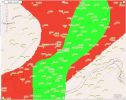
Good info there.
As far as I can see there are also quite a few wells in the area.

new topics
-
Gen Flynn's Sister and her cohort blow the whistle on DHS/CBP involvement in child trafficking.
Whistle Blowers and Leaked Documents: 1 hours ago -
Anybody else using Pomodoro time management technique?
General Chit Chat: 4 hours ago -
Bucks County commissioners vote to count illegal ballots in Pennsylvania recount
2024 Elections: 6 hours ago -
Trump sues media outlets -- 10 Billion Dollar lawsuit
US Political Madness: 7 hours ago -
Fired fema employee speaks.
US Political Madness: 7 hours ago -
How long till it starts
US Political Madness: 9 hours ago -
USSS Agent Fired for Having Sex In Michelle Obama's Bathroom
Politicians & People: 10 hours ago
top topics
-
Trump sues media outlets -- 10 Billion Dollar lawsuit
US Political Madness: 7 hours ago, 21 flags -
Bucks County commissioners vote to count illegal ballots in Pennsylvania recount
2024 Elections: 6 hours ago, 17 flags -
How long till it starts
US Political Madness: 9 hours ago, 15 flags -
USSS Agent Fired for Having Sex In Michelle Obama's Bathroom
Politicians & People: 10 hours ago, 9 flags -
Fired fema employee speaks.
US Political Madness: 7 hours ago, 9 flags -
Watching TV
Jokes, Puns, & Pranks: 13 hours ago, 8 flags -
Gen Flynn's Sister and her cohort blow the whistle on DHS/CBP involvement in child trafficking.
Whistle Blowers and Leaked Documents: 1 hours ago, 3 flags -
Anybody else using Pomodoro time management technique?
General Chit Chat: 4 hours ago, 2 flags
active topics
-
How long till it starts
US Political Madness • 12 • : yuppa -
President-Elect DONALD TRUMP's 2nd-Term Administration Takes Shape.
Political Ideology • 199 • : xuenchen -
The Trump effect 6 days after 2024 election
2024 Elections • 138 • : Xtrozero -
The Acronym Game .. Pt.4
General Chit Chat • 959 • : JJproductions -
Trump sues media outlets -- 10 Billion Dollar lawsuit
US Political Madness • 34 • : WeMustCare -
Bucks County commissioners vote to count illegal ballots in Pennsylvania recount
2024 Elections • 17 • : xuenchen -
How can you defend yourself when the police will not tell you what you did?
Posse Comitatus • 81 • : SCUBAPAUL -
Gen Flynn's Sister and her cohort blow the whistle on DHS/CBP involvement in child trafficking.
Whistle Blowers and Leaked Documents • 5 • : xuenchen -
Anybody else using Pomodoro time management technique?
General Chit Chat • 6 • : Cloudbuster1 -
WATCH LIVE: US Congress hearing on UFOs, unidentified anomalous phenomena
Aliens and UFOs • 83 • : DaydreamerX
