It looks like you're using an Ad Blocker.
Please white-list or disable AboveTopSecret.com in your ad-blocking tool.
Thank you.
Some features of ATS will be disabled while you continue to use an ad-blocker.
share:
NJ needs another good bath anyhow. Seriously though, in NY many of the weak trees and limbs were brought down last year with the Hurricane and the
massive October '11 snowstorm, so the majority of tree pruning has been freshly done.
My basement pumps and generator are all ready. Bring it.
"...and the trees were all kept equal..." -Rush
My basement pumps and generator are all ready. Bring it.
"...and the trees were all kept equal..." -Rush
Note the white area and the scale 0-10 colors (there is no white) BE SAFE!

Haarp Status

Haarp Status
edit on 26-10-2012 by Staroth because: (no reason given)
We have been following this thread for the past two days with interest in what people are saying and not the MSM and we have garnered some very good
information and links.
We are Located in Southern Ontario and we are not that worried, but yet we do already have some stuff done before this storm was on the radar so to speak.
4 face cords of firewood ...check Batteries...check.....Lots of canned goods and non perishables......check
40 pounds of propane for our BBQ....check.....toilet paper and such check......
Water no, but we will have three days without power here before water becomes scarce.....
This storm reminds us of the big big Nor'easter that Sunk the Edmund Fitzgerald, and keep in mind this did not include a Hurricane.
This beautiful ship cruised past our city almost daily doing the iron run from the mines to Detroit.
Everybody recognized her as she was very big.
The wreck of the Edmund Fitzgerald with the words link below
www.youtube.com...
Very old video but enjoy the the history here, filmed in 1976
www.youtube.com...
A more recent video, with a very aged Gorden Light foot but no less talented.
www.youtube.com...
Here is the storm system that brought her down and this did not even include a Hurricane
cimss.ssec.wisc.edu...
www.youtube.com...
To the OP S&F and to all the posters here thanks so much for keeping us all informed with the latest updates and your personal stories regarding Hurricanes and dangerous weather systems in general.
I should add here that my brother in law is a captain on a major ferry so the maritime theme to my post.
Land on the coasts will be very dangerous, on the water lord help you.
Regards, Iwinder
edit on 26-10-2012 by Iwinder because: (no reason given)
edit on 26-10-2012 by Iwinder because: (no reason
given)
Absolutely no idea what HAARP has to do with any of this, BUT here is the latest from NOAA as of 8pm, and remember this is for the area that Sandy is
not even touching:
Partial quote from:
www.nhc.noaa.gov...
and I just wanted to add, thanks for the compliments in general earlier...i just want people to be informed and prepared...bickering about this storm being nothing, or doomsday is pointless...she is simply HUGE.
Partial quote from:
www.nhc.noaa.gov...
ADDITIONAL RAINFALL
ACCUMULATIONS OF 1 TO 2 INCHES ARE EXPECTED OVER PORTIONS OF
EASTERN FLORIDA...WITH ISOLATED MAXIMUM AMOUNTS OF 6 INCHES
POSSIBLE. RAINFALL TOTALS OF 4 TO 8 INCHES ARE POSSIBLE OVER FAR
EASTERN NORTH CAROLINA.
STORM SURGE...THE COMBINATION OF A DANGEROUS STORM SURGE AND THE
TIDE WILL CAUSE NORMALLY DRY AREAS NEAR THE COAST TO BE FLOODED BY
RISING WATERS. THE WATER COULD REACH THE FOLLOWING DEPTHS ABOVE
GROUND IF THE PEAK SURGE OCCURS AT THE TIME OF HIGH TIDE...
BAHAMAS WITHIN THE WARNING AREA...3 TO 5 FT
FLORIDA COAST WITHIN WARNING AREA...1 TO 3 FT
NORTH CAROLINA WITHIN THE WARNING AREA...3 TO 5 FT
REMAINDER OF NORTH CAROLINA AND SE VIRGINIA INCLUDING LOWER
CHESAPEAKE BAY...2 TO 4 FT
and I just wanted to add, thanks for the compliments in general earlier...i just want people to be informed and prepared...bickering about this storm being nothing, or doomsday is pointless...she is simply HUGE.
edit on 26-10-2012 by lasertaglover because: forgot to thank some
people
edit on Fri Oct 26 2012 by DontTreadOnMe because: IMPORTANT: Using
Content From Other Websites on ATS
Originally posted by seaside sky
reply to post by Staroth
I'm in the white area....
What does this mean?
I would suspect that white means big trouble in the near future but do not take my post here as being anywhere near expert.
Regards, Iwinder
Ok, so don't beat me up cause this is from The Weather Channel, cause it is a quote they are using from a NOAA guy. I can't stand the weather channel
myself, the notion of getting ratings during destruction bothers me (even though I will admit that I do like watching goofy Jim Cantore do his thing).
But this information from the NOAA guy is important:
Partial quote from the Weather Channel:
www.weather.com...
Stay safe people!
Peace
Partial quote from the Weather Channel:
www.weather.com...
"National Oceanic and Atmospheric Administration forecaster Jim Cisco said: "We don't have many modern precedents for what the models are suggesting."
Government forecasters said there is a 90 percent chance -- up from 60 percent two days earlier -- that the East will get pounded.
Coastal areas from Florida to Maine will feel some effects, but the storm is expected to vent the worst of its fury on New Jersey and the New York City area, which could see around 5 inches of rain and gale-force winds close to 40 mph.
Eastern Ohio, southwestern Pennsylvania and West Virginia could get snow.
And the storm will take its time leaving. The weather may not start clearing in the mid-Atlantic until the day after Halloween and Nov. 2 in the upper Northeast, Cisco said.
Stay safe people!
Peace
edit on 26-10-2012 by lasertaglover because: spelling
edit on Fri Oct 26 2012 by DontTreadOnMe because:
IMPORTANT: Using Content From Other Websites on ATS
East of Pittsburgh, PA...Gov. Tom Corbett has declared PA to be in a state of emergency...the entire commonwealth. Here in the southwest, our trees
still have ALOT of heavy foliage...which causes a two fold problem w/heavy wet snow. One, tree limbs will snap and pull down power lines and two, all
of the leaves, with combo of rain and eventual melting snow will clog gutters, downspouts, storm sewers, creeks and streams. The flooding (along with
days--or a week or more of no power) will be beyond awful. Our snow amounts (into eastern OH and down into WV will be over a foot--more in the higher
elevations.
Some here are being lulled into "it's too warm" (it was in the 70s today; an expected 25 degree drop tomorrow and another 10 plus degree drop for Sunday (as the cold front from the west closes in). By Monday even colder!
Some here are being lulled into "it's too warm" (it was in the 70s today; an expected 25 degree drop tomorrow and another 10 plus degree drop for Sunday (as the cold front from the west closes in). By Monday even colder!
Folks Latest Updates:
1) Rainfall Amount for NJ and NY is about 8 Inches from now to Tuesday, now remember this storm will be moving slow so it will stay till wed night maybe even Thursday, I believe rainfall amounts will be 15+ in NJ and NY and PA, Major Flooding that nobody has ever seen yet, I am saying this because in NJ its been raining lately a lot lately and ground has a lot of moisture. Here is the Link for the rainfall through Tuesday.
2) A lot of trees will be torn apart, since the tress roots are weekend by hurricane Irene and the last snowstorm from October, this will cause major power outages along the east coast.
3) Track as of Now indicates a direct Hit into central jersey or right in the corner of NJ and NYC. If this track is right, we can face serious damage and a lot of power outages and destruction.
4) They are saying winds up to 75mph + can last for 48 hrs in NJ and NY, just imagine how will that be, i can all ready picture this.
5) Few meteorologist don't even know what will happen when this cold front merges with the storm, it can strengthen more than they are advising. Sometimes they don't want people to panic, so they will advise the real warnings at the last day before the storm arrives, so lets wait and see what happens.
edit on 26-10-2012 by storm2012 because: (no reason given)
reply to post by storm2012
Great update and thanks!
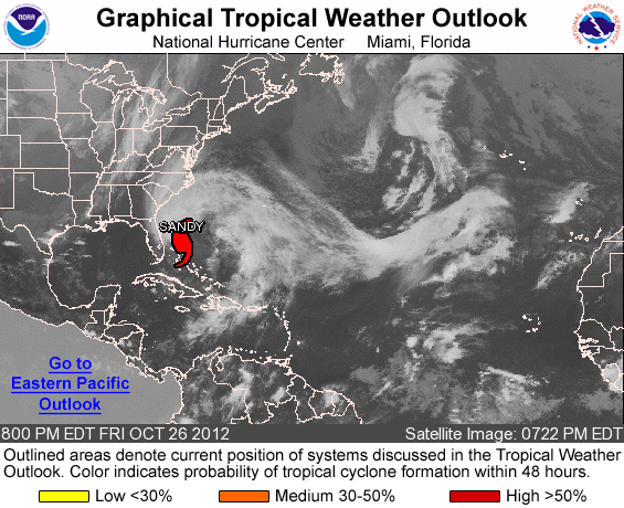
It's hard for me to wrap my head around how big Sandy really is. You can tell from this pic that she is still raining on Haiti, and raining on North Carolina at the same time. Crazy!
www.nhc.noaa.gov...

Peace
Great update and thanks!
It's hard for me to wrap my head around how big Sandy really is. You can tell from this pic that she is still raining on Haiti, and raining on North Carolina at the same time. Crazy!
www.nhc.noaa.gov...

Peace
Originally posted by lasertaglover
reply to post by storm2012
Great update and thanks!
It's hard for me to wrap my head around how big Sandy really is. You can tell from this pic that she is still raining on Haiti, and raining on North Carolina at the same time. Crazy!
www.nhc.noaa.gov...
Peace
Lets see how big this storm become when the cold front merges and forms a Nor Easter. I am located right on the track of the storm, kind of excited, but at the same time a lil worried , if this thing turns out to be life threatening.
reply to post by storm2012
Be well, my friend, and take the solace of the community of ATS with you!
Be well, my friend, and take the solace of the community of ATS with you!
reply to post by lasertaglover
Funny, that shows the western edge of the storm completely covering me right now in SC (Charleston), but it's not raining a bit, hasn't been all day!
Funny, that shows the western edge of the storm completely covering me right now in SC (Charleston), but it's not raining a bit, hasn't been all day!
reply to post by 00nunya00
That image is showing cloud cover only. Sandy is still raining in Haiti according to NOAA, and bands of rain are already hitting parts of the eastern seaboard.
I posted that pic to demonstrate the size of the storm. It is an overhead satelite image, not doppler radar.
Fyi, there is a new Sandy thread over in the Survival forum that looks interesting and has some good advice.
www.abovetopsecret.com...
Gallows humor...
So yah - I'm sitting in NJ & every computer model is making a B-line for my hometown. I don't know what do you do give Jim Cantore a high-five on the town square?
No power is gonna suck!
Maybe we can get gun confiscation to boot!
Peace

So yah - I'm sitting in NJ & every computer model is making a B-line for my hometown. I don't know what do you do give Jim Cantore a high-five on the town square?
No power is gonna suck!
Maybe we can get gun confiscation to boot!
Peace

edit on 26-10-2012 by BABYBULL24 because: (no reason given)
reply to post by 00nunya00
Ah, I live in Charleston, too! You'd think that a storm hitting both Florida and North Carolina would do something sinister to the states in between. I'm relieved that this doesn't seem to be the case.
Ah, I live in Charleston, too! You'd think that a storm hitting both Florida and North Carolina would do something sinister to the states in between. I'm relieved that this doesn't seem to be the case.
edit on 27-10-2012 by EllaMarina because: (no reason given)
Originally posted by EllaMarina
reply to post by 00nunya00
Ah, I live in Charleston, too! You'd think that a storm hitting both Florida and North Carolina would do something sinister to the states in between. I'm relieved that this doesn't seem to be the case.
edit on 27-10-2012 by EllaMarina because: (no reason given)
For sure, but I'm just waiting to see the evidence of this alleged turn it's going to take----I think about the Hugo path and how it never really made that classic turn at all. I know these conditions are much different, but still......sometimes those paths look very ominous for us, but usually never hit, thank God!
Latest From the Discussian at NOAA
Stay safe everybody
IN 48-72 HR. HOWEVER...THE CYCLONE WILL BE UNDERGOING EXTRATROPICAL TRANSITION AS THIS HAPPENS...AND WHEN THIS PROCESS WILL BE COMPLETE IS UNCERTAIN. REGARDLESS OF THE EXACT STRUCTURE AT LANDFALL...SANDY IS EXPECTED TO BE A LARGE AND POWERFUL CYCLONE WITH SIGNIFICANT IMPACTS EXTENDING WELL AWAY FROM THE LOCATION OF THE CENTER
Stay safe everybody
edit on 27-10-2012 by violet because: (no reason given)
be safe guys, really hope your going to be alright up there
could this be a sign to a mini ice age ?
could this be a sign to a mini ice age ?
reply to post by Nyiah
Speak for yourself cause as a " new englander" my self ain't nobody around me scared of no wind I don't know where you get that assumption from. just because our area ain't prone to being hit with all types of natural disasters don't mean when they come we don't know how to work together and tough it out, after all its not like were abunch of dum hicks up hear. ( ask your dolphins how much of wusses we are when the N.E patriots come there to play lol )
Speak for yourself cause as a " new englander" my self ain't nobody around me scared of no wind I don't know where you get that assumption from. just because our area ain't prone to being hit with all types of natural disasters don't mean when they come we don't know how to work together and tough it out, after all its not like were abunch of dum hicks up hear. ( ask your dolphins how much of wusses we are when the N.E patriots come there to play lol )
new topics
-
Letters to the Editor: Altadena, my neighborhood, has burned. Make fossil-fuel companies pay
Propaganda Mill: 1 hours ago -
The LEGACY of Outgoing President JOSEPH R. BIDEN Jr. - Forced From Office Eff 1.20.2025.
US Political Madness: 1 hours ago -
UK and Europe Floods
Rant: 3 hours ago -
FEMA kicks hurricane survivors out of temporary housing into snowstorm and freezing temperatures
Disaster Conspiracies: 3 hours ago -
Failures of leadership on display
US Political Madness: 4 hours ago -
Power grid faults surged right before Los Angeles wildfires began
Mainstream News: 4 hours ago -
Tustin California Military equipment stolen BIG equipment .
Social Issues and Civil Unrest: 4 hours ago -
PALES-TINE, PALES-ADES and the Australian Aboriginal "Lightning Man"
Dreams & Predictions: 4 hours ago
top topics
-
FEMA kicks hurricane survivors out of temporary housing into snowstorm and freezing temperatures
Disaster Conspiracies: 3 hours ago, 15 flags -
Tustin California Military equipment stolen BIG equipment .
Social Issues and Civil Unrest: 4 hours ago, 14 flags -
Failures of leadership on display
US Political Madness: 4 hours ago, 11 flags -
Letters to the Editor: Altadena, my neighborhood, has burned. Make fossil-fuel companies pay
Propaganda Mill: 1 hours ago, 10 flags -
How To Spot Fake U.F.O. Photos
Aliens and UFOs: 16 hours ago, 8 flags -
Power grid faults surged right before Los Angeles wildfires began
Mainstream News: 4 hours ago, 7 flags -
UK and Europe Floods
Rant: 3 hours ago, 6 flags -
PALES-TINE, PALES-ADES and the Australian Aboriginal "Lightning Man"
Dreams & Predictions: 4 hours ago, 5 flags -
The LEGACY of Outgoing President JOSEPH R. BIDEN Jr. - Forced From Office Eff 1.20.2025.
US Political Madness: 1 hours ago, 4 flags
active topics
-
The Truth about Migrant Crime in Britain.
Social Issues and Civil Unrest • 50 • : angelchemuel -
Tustin California Military equipment stolen BIG equipment .
Social Issues and Civil Unrest • 12 • : WickedChihuahua -
Letters to the Editor: Altadena, my neighborhood, has burned. Make fossil-fuel companies pay
Propaganda Mill • 3 • : hangedman13 -
To become president, Zelensky had to learn Ukrainian
Political Conspiracies • 54 • : Oldcarpy2 -
This should be plastered all over the airwaves
Mainstream News • 60 • : awhispersecho -
New UK Petition - Close the borders! Suspend ALL immigration for 5 years!
Regional Politics • 24 • : gortex -
Power grid faults surged right before Los Angeles wildfires began
Mainstream News • 9 • : Mantiss2021 -
FEMA kicks hurricane survivors out of temporary housing into snowstorm and freezing temperatures
Disaster Conspiracies • 15 • : marg6043 -
Los Angeles brush fires latest: 2 blazes threaten structures, prompt evacuations
Mainstream News • 419 • : Oldcarpy2 -
Trump says ownership of Greenland 'is an absolute necessity'
Other Current Events • 204 • : BedevereTheWise
