It looks like you're using an Ad Blocker.
Please white-list or disable AboveTopSecret.com in your ad-blocking tool.
Thank you.
Some features of ATS will be disabled while you continue to use an ad-blocker.
share:
Reported on the WC..
Most of Atlantic City is under water..
Already..
They also showed some video of Cape May where the water is already spilling into the street from the surf..
Most of Atlantic City is under water..
Already..
They also showed some video of Cape May where the water is already spilling into the street from the surf..
Sandy has officially bumped the historic record-holder 1938 hurricane to number TWO in the lowest pressure of a hurricane north of Hatteras.
It is now THE lowest pressure system in recorded history for this area.
It is now THE lowest pressure system in recorded history for this area.
edit on 10-29-2012 by Valhall because: (no reason given)
Route 1 in Delaware is closed. That's the evacuation route from S. Delaware.
Ocean and sand is covering parts of it. It closed last night, but has gotten worse ..
No evacs from S. Delaware or the coast ....
Ocean and sand is covering parts of it. It closed last night, but has gotten worse ..
No evacs from S. Delaware or the coast ....
Originally posted by Valhall
It is now THE lowest pressure system in recorded history for this area
That really low pressure eye is supposed to go right over us at 2 AM.
I'm wondering what low pressure will do to the body ...
Especially my autoimmune ridden body. Maybe nothing. Maybe something.
I guess we'll find out.
Meanwhile, Atlantic City's public safety director says most of the city is under water. Willie Glass says the city is basically flooded and it looks like the damage will be worse than the storm of 1962. Fire officials in Pleasantville report at least two rescues from homes surrounded by water and two more rescues are under way.
abclocal.go.com...
Garden State Parkway is also shut down in two locations down by Atlantic City due to flooding. They warn to expect more of it will also be closed as
the storm approaches.
abclocal.go.com...
abclocal.go.com...
Norfolk is flooding.
United Illuminating is warning its customers that about 35,500 of them will lose power about noon when a power station gets flooded out.
United Illuminating is warning its customers that about 35,500 of them will lose power about noon when a power station gets flooded out.
Another thing to keep an eye on are the inlet bays, when they start receding it is only giving more strenght to what the surge will become at hightide
after nightfall. The ocean literally sucks water energy from the inlets and then builds up for the tidal surge.
reply to post by JacKatMtn
Saw that and the text is pretty scary as it shows sustained wind speeds at much higher rates than expected for a cat one which we have already said is dangerous info for most ppl who have 'ridden out' much larger events.
Saw that and the text is pretty scary as it shows sustained wind speeds at much higher rates than expected for a cat one which we have already said is dangerous info for most ppl who have 'ridden out' much larger events.
reply to post by FlyersFan
I have been in so much pain the past few days, I swear the inside of my bones hurt.
If the power doesn't go out, I am going to sit in a sauna out of desperation.
I have been in so much pain the past few days, I swear the inside of my bones hurt.
If the power doesn't go out, I am going to sit in a sauna out of desperation.
reply to post by Valhall
Just saw that the 3 main power supply chains are reporting upwards of 10k without power now.
Just saw that the 3 main power supply chains are reporting upwards of 10k without power now.
Looks like Tx is under the gun now too. From weather channel feed:
Twitter
TWC_Shawn:
#Hail near Goodnight, TX shatters the windshields of 3 of our #TornadoHunt vehicles.
With the size of this monster storm it is hard to tell how far across the US it is going to move.
So much moisture from the south traveling on the hurricane winds meeting with the northern cold front heading down from Canada.
www.weather.com...
edit on 29-10-2012 by antar because: (no reason given)
Some pictures of local damages.
imgur.com...
Edit to add - They are not my personal pictures.
imgur.com...
Edit to add - They are not my personal pictures.
edit on 29-10-2012 by Doodle19815 because: (no reason given)
reply to post by antar
I'm confused here, those tweets are dated April 30th?
Radar shows no significant weather over TX at the moment.
I'm confused here, those tweets are dated April 30th?
Radar shows no significant weather over TX at the moment.
Best of luck to all those 'riding it out' and thanks for all the constant feedback. I'm in South Africa but keeping a close eye on proceedings there.
Right now we are in the middle of a massive lightning storm. The weather has been crazy here for the last few weeks. Constant rain and storms when we're suppose to be having lovely weather.
I inspect buildings for a living and know that tomorrow I will be running about like crazy.
Posted Via ATS Mobile: m.abovetopsecret.com
Right now we are in the middle of a massive lightning storm. The weather has been crazy here for the last few weeks. Constant rain and storms when we're suppose to be having lovely weather.
I inspect buildings for a living and know that tomorrow I will be running about like crazy.
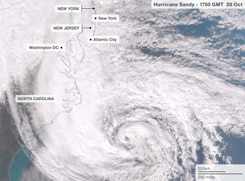
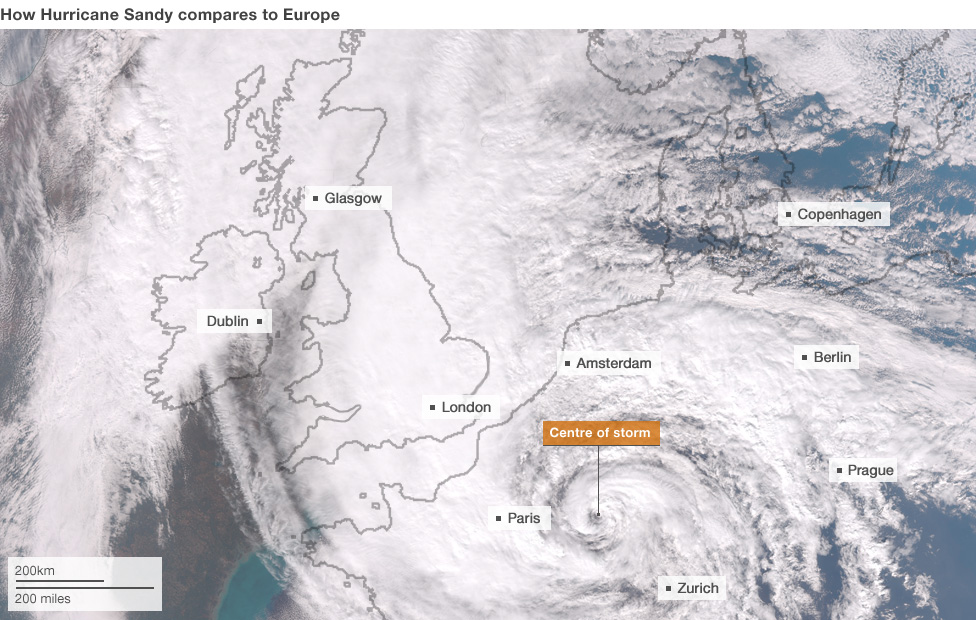
I thought this was an interesting comparison done by BBC News.
From this page:
That is pretty amazing.
From this page:
Hurricane Sandy is huge and its winds could stretch across the eastern third of the US by Monday night, according to the National Hurricane Center. Here's what the storm would look like if its centre were over western Europe:
That is pretty amazing.
I hope that everyone has their insurance paid up because there will be a lot of real estate damaged (if not lost- doesn't look promising for the
islands Chincotigue and Assatigue and the other low lying islands.
new topics
-
Letters to the Editor: Altadena, my neighborhood, has burned. Make fossil-fuel companies pay
Propaganda Mill: 5 minutes ago -
The LEGACY of Outgoing President JOSEPH R. BIDEN Jr. - Forced From Office Eff 1.20.2025.
US Political Madness: 7 minutes ago -
UK and Europe Floods
Rant: 2 hours ago -
FEMA kicks hurricane survivors out of temporary housing into snowstorm and freezing temperatures
Disaster Conspiracies: 2 hours ago -
Failures of leadership on display
US Political Madness: 2 hours ago -
Power grid faults surged right before Los Angeles wildfires began
Mainstream News: 2 hours ago -
Tustin California Military equipment stolen BIG equipment .
Social Issues and Civil Unrest: 3 hours ago -
PALES-TINE, PALES-ADES and the Australian Aboriginal "Lightning Man"
Dreams & Predictions: 3 hours ago
top topics
-
Tustin California Military equipment stolen BIG equipment .
Social Issues and Civil Unrest: 3 hours ago, 13 flags -
FEMA kicks hurricane survivors out of temporary housing into snowstorm and freezing temperatures
Disaster Conspiracies: 2 hours ago, 13 flags -
Failures of leadership on display
US Political Madness: 2 hours ago, 11 flags -
How To Spot Fake U.F.O. Photos
Aliens and UFOs: 15 hours ago, 8 flags -
UK and Europe Floods
Rant: 2 hours ago, 6 flags -
Scary video of face in an abandoned house
Paranormal Studies: 17 hours ago, 6 flags -
Power grid faults surged right before Los Angeles wildfires began
Mainstream News: 2 hours ago, 6 flags -
PALES-TINE, PALES-ADES and the Australian Aboriginal "Lightning Man"
Dreams & Predictions: 3 hours ago, 5 flags -
The LEGACY of Outgoing President JOSEPH R. BIDEN Jr. - Forced From Office Eff 1.20.2025.
US Political Madness: 7 minutes ago, 1 flags -
Letters to the Editor: Altadena, my neighborhood, has burned. Make fossil-fuel companies pay
Propaganda Mill: 5 minutes ago, 0 flags
active topics
-
Power grid faults surged right before Los Angeles wildfires began
Mainstream News • 5 • : fringeofthefringe -
To become president, Zelensky had to learn Ukrainian
Political Conspiracies • 50 • : Imhere -
Trump says ownership of Greenland 'is an absolute necessity'
Other Current Events • 194 • : Lazy88 -
Los Angeles brush fires latest: 2 blazes threaten structures, prompt evacuations
Mainstream News • 414 • : Mantiss2021 -
Labour Plotting to Postpone May's Council Elections ?
Regional Politics • 24 • : angelchemuel -
Letters to the Editor: Altadena, my neighborhood, has burned. Make fossil-fuel companies pay
Propaganda Mill • 0 • : xuenchen -
The LEGACY of Outgoing President JOSEPH R. BIDEN Jr. - Forced From Office Eff 1.20.2025.
US Political Madness • 0 • : WeMustCare -
Failures of leadership on display
US Political Madness • 10 • : NoCorruptionAllowed -
UK and Europe Floods
Rant • 1 • : angelchemuel -
Tustin California Military equipment stolen BIG equipment .
Social Issues and Civil Unrest • 6 • : Mantiss2021


