It looks like you're using an Ad Blocker.
Please white-list or disable AboveTopSecret.com in your ad-blocking tool.
Thank you.
Some features of ATS will be disabled while you continue to use an ad-blocker.
share:
reply to post by antar
Thank you, that was nice. You are right, we just might be picked off one by one as our power goes out. LOL
We should have a contest, see which poster in the hurricane zone lasts the longest.
Thank you, that was nice. You are right, we just might be picked off one by one as our power goes out. LOL
We should have a contest, see which poster in the hurricane zone lasts the longest.
Sandy we are waiting for you 16 more hours left before the eye of the storm is on top of me .
Originally posted by nixie_nox
reply to post by antar
Thank you, that was nice. You are right, we just might be picked off one by one as our power goes out. LOL
We should have a contest, see which poster in the hurricane zone lasts the longest.
that sounds like fun and here's to hoping we all stay online through this thing.
I'm very interested to see how much snow this *Hybrid* system actually produces.Its still windy here. The fact that this thing is so huge and moving
at a snails pace makes it worse! I'm also watching closely how the pressure is dropping.
Full Moon, High Tide, Huge Waves................
Full Moon, High Tide, Huge Waves................
News keeps flying in. I wish the best to the East Coast. Be safe.
Source


-SAP-
Update -- 05:40pm EST Sunday, 10/28/2012
Alerts Broadcaster Update: A potential 1 in 100 year storm is still on track to deliver a punishing blow on Monday, from coastal Delaware and New Jersey to New York, Long Island, Cape Cod and Boston Harbor. Little has change in the last 8-12 hours, if anything the computer models we've been studying since Sunday are coming into even closer alignment.
Source


Sandy will last for up to 36 hours, with some forecasters saying the storm could essentially stall out once it makes landfall. Hurricanes, nor’easters and other storms in southern New England have typically lasted for 12 hours or less, Malloy said.
-SAP-
edit on 28-10-2012 by SloAnPainful because: (no reason given)
Originally posted by Druid42
Everyone be SAFE. Our thoughts go out to you people on the coast!
This is getting to be surreal.
I am watching this thread and this one.
If you can, get pics/vids. This is sure to be a very memorable event, but most of all STAY SAFE!
i ll try to get pics and videos if possible and post them on this thread.
FEMA estimations...Not looking good. I wish the best to our East Coast friends...This is gonna hurt....
Source
-SAP-
Sandy's winds could cause up to $3 billion damage, FEMA estimates.
[Update 10:04 p.m. ET] FEMA estimates that Hurricane Sandy has the potential to cause $2.5 billion to $3 billion in wind damage alone in the United States. The estimate, using standardized methodology called HAZUS, does not account for potential flood and other damage.
[Update 9:44 p.m. ET] All bus carriers serving the New York area's Port Authority Bus Terminal - including Greyhound, Trailways and airport shuttles - are suspended because of the hurricane, the Port Authority of New York and New Jersey announced.
[Update 8:55 p.m. ET] New York's Staten Island Ferry and East River Ferry services are suspended at least through Monday, according to the city's severe weather Web page.
Source
-SAP-
edit on 28-10-2012 by SloAnPainful because: (no reason given)
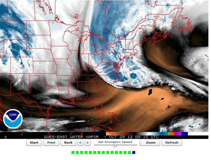
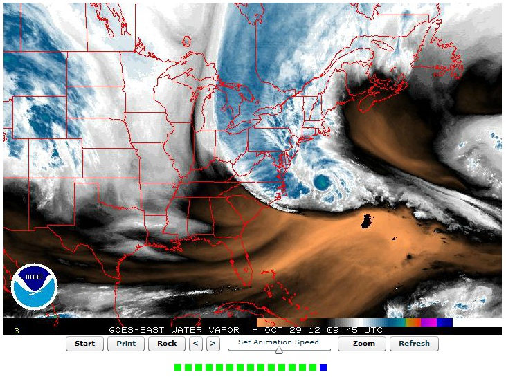
Here's Sandy's current location:
Hold on to your seat belts! This is gonna be a rough ride for you East Coasters. Be safe, and be careful!
Monday and Tuesday will be telling, as she makes landfall.....
Hold on to your seat belts! This is gonna be a rough ride for you East Coasters. Be safe, and be careful!
Monday and Tuesday will be telling, as she makes landfall.....
Latest update:
www.nhc.noaa.gov...
HURRICANE FORCE WINDS EXTEND OUTWARD UP TO 175 MILES...
280 KM...MAINLY TO THE SOUTHWEST OF THE CENTER...AND TROPICAL STORM
FORCE WINDS EXTEND OUTWARD UP TO 520 MILES...835 KM. WEATHERFLOW
STATIONS AT LEWES DELAWARE AND TUCKERTON NEW JERSEY REPORTED
SUSTAINED WINDS OF 42 MPH AND GUSTS TO 52 MPH.
STORM SURGE...THE COMBINATION OF AN EXTREMELY DANGEROUS STORM SURGE
AND THE TIDE WILL CAUSE NORMALLY DRY AREAS NEAR THE COAST TO BE
FLOODED BY RISING WATERS. THE WATER COULD REACH THE FOLLOWING
DEPTHS ABOVE GROUND IF THE PEAK SURGE OCCURS AT THE TIME OF HIGH
TIDE...
NC NORTH OF SURF CITY INCLUDING PAMLICO/ALBEMARLE SOUNDS...4 TO 6 FT
SE VA AND DELMARVA INCLUDING LOWER CHESAPEAKE BAY...2 TO 4 FT
UPPER AND MIDDLE CHESAPEAKE BAY...1 TO 3 FT
LONG ISLAND SOUND...RARITAN BAY...AND NEW YORK HARBOR...6 TO 11 FT
ELSEWHERE FROM OCEAN CITY MD TO THE CT/RI BORDER...4 TO 8 FT
CT/RI BORDER TO THE SOUTH SHORE OF CAPE COD INCLUDING BUZZARDS
BAY AND NARRAGANSETT BAY...3 TO 6 FT
CAPE COD TO THE MA/NH BORDER INCLUDING CAPE COD BAY...2 TO 4 FT
MA/NH BORDER TO THE U. S./CANADA BORDER...1 TO 3 FT
www.nhc.noaa.gov...
Holy crap people. They just reported that it has strengthened. Look at this satellite photo at 4:15 a.m. ET. Look at how well-defined the eye just
got and how HUGE the eye is.

This is a very very scary storm.

This is a very very scary storm.
[Update 3:54 a.m. ET] The Coast Guard is responding to a distress call from a ship that is part of the popular culture. The HMS Bounty, a tall ship built for the 1962 movie "Mutiny on the Bounty," is taking on water off the coast of North Carolina - about 160 miles from the center of Hurricane Sandy. The Coast Guard says it has “diminished search and rescue capabilities due to the storm.” Seventeen people are on board.
news.blogs.cnn.com...
reply to post by SilverWraith
Praying for the 17 brave souls on board. I'm sure they headed out to try to save the ship. God bless their hearts because the Coast Guard statement was not very encouraging for a rescue.
Praying for the 17 brave souls on board. I'm sure they headed out to try to save the ship. God bless their hearts because the Coast Guard statement was not very encouraging for a rescue.
Originally posted by Valhall
Holy crap people. They just reported that it has strengthened. Look at this satellite photo at 4:15 a.m. ET. Look at how well-defined the eye just got and how HUGE the eye is.
This is a very very scary storm.
Thank God the center didnt crash into NC or some where. Had it, the thing would have reached past the misissippi with more damage toward the center than we are going to see as it stands now.
Is this going to be a real one then, not like the one they hyped up last time that turned out to be about as bad as a windy day on the hills in
Scotland?
Irene was it?
Irene was it?
new topics
top topics
-
Federal law trumps state and local law every time
Social Issues and Civil Unrest: 17 hours ago, 17 flags
active topics
-
Petition Calling for General Election at 564,016 and rising Fast
Political Issues • 94 • : Freeborn -
-@TH3WH17ERABB17- -Q- ---TIME TO SHOW THE WORLD--- -Part- --44--
Dissecting Disinformation • 3384 • : brewtiger123 -
BIDEN Admin Begins Planning For January 2025 Transition to a New President - Today is 4.26.2024.
2024 Elections • 59 • : WeMustCare -
DOJ Special Counsel Robert HUR Says JOE BIDEN Can Be ARRESTED After Jan 20th 2025.
Above Politics • 30 • : WeMustCare -
On Nov. 5th 2024 - AMERICANS Prevented the Complete Destruction of America from Within.
2024 Elections • 160 • : WeMustCare -
Results of the use of the Oreshnik missile system in Dnepropetrovsk
World War Three • 240 • : 777Vader -
Both KAMALA and OBAMA are on the Nov 5th 2024 Ballot - If One Loses - Both Lose.
2024 Elections • 9 • : WeMustCare -
How many people, in GENERAL, are musically inclined?
Music • 26 • : Huronyx -
Well, here we go red lines crossed Biden gives the go ahead to use long range missiles
World War Three • 395 • : annonentity -
Federal law trumps state and local law every time
Social Issues and Civil Unrest • 30 • : ADVISOR

