It looks like you're using an Ad Blocker.
Please white-list or disable AboveTopSecret.com in your ad-blocking tool.
Thank you.
Some features of ATS will be disabled while you continue to use an ad-blocker.
share:
US Gov’t: “Tsunami debris might be contaminated with radiation from Fukushima Dai-ichi”
Published: April 7th, 2012 at 8:47 pm ET
By ENENews
Email Article Email Article
17 comments
Tweet
Though NOAA has consistently claimed tsunami debris threatening North America will not be radioactive. A new paper by the Congressional Research Service says otherwise.
Effects of Radiation from Fukushima Dai-ichi on the U.S. Marine Environment
Congressional Research Service
Eugene H. Buck, Specialist in Natural Resources Policy
Harold F. Upton, Analyst in Natural Resources Policy
April 2, 2012
[...] Initial models suggested that in a year, debris could reach the Northwestern Hawaiian Islands Marine National Monument; in two years, the remaining Hawaiian islands could see this debris; in three years, the debris plume likely would reach the U.S. west coast, dumping debris on California beaches and the beaches of British Columbia, Alaska, and Baja California.
Although much of the radioactive release from Fukushima Dai-ichi is believed to have occurred after the tsunami, there is the possibility that some of the tsunami debris might be contaminated with radiation from Fukushima Dai-ichi.
More recent observations indicate that some debris could be traveling faster than predicted. The debris field has been estimated to contain possibly millions of tons of debris and to be approximately 3,700 kilometers long and 1,800 kilometers wide. [...]
Tracking Japan’s Floating Tsunami Debris as it Drifts Towards California – UPDATE: It Arrived
26 12 2011
There is a worry over the vast amount of floating debris pulled out to sea by the big tsunami that hit Japan last March. Some are concerned a lot of it is radioactive, others fear ruin of pristine beaches on Hawaii and other locations and seamen find it is interfering with shipping lanes.
Here are some tools to keep up with the looming problem.
Resources for Tracking the Floating Debris Field
NEW > Japan Tsunami Marine Debris Joint Information Center
Google Maps, Canada Debris Tracking MAP – more
Tsunami Debris Tracking Project
www.oceanrecov.org...
and their other mapping project using the SCUD model of the surface ocean currents (easy to see)
Radiation modelling maps from ASR has tools for predicting Fukushima related events
www.asrltd.com...
Marine Debris.Info – public listserve for news
marineaffairs.org...
Animated MAP of the Projected Path
iprc.soest.hawaii.edu...
Map of Marine Debris Tracking Buoys (interactive, check North Pacific) Has Live Data and Satellite view -
www.atiak.com...
Satellite Images – look for yourself
www.osdpd.noaa.gov...
The NOAA Marine Debris Page on it
marinedebris.noaa.gov...
Marine Debris Tracker smartphone application
www.marinedebris.engr.uga.edu...
NOAA Video of the debris
youtu.be...
Hawaii – Maui – INDIEGOGO sailing to track the debris
www.indiegogo.com...
5 Gyres research ship
5gyres.org...
PHOTOS of the debris at sea
news.ninemsn.com.au...
IN ALASKA – if you come across tsunami debris the Alaska Dispatch requests you report it using contact at the bottom of this page.
flyingcuttlefish.wordpress.com...
Why would they sink a ship, if it was not radioactive, is the question, that we all should be asking, imho, as the price of metal and salvaging it alone, should be more than enough clues, that it was contaminated..
Why did they wait for it to get some close to shore is the next one..
edit on 29-4-2012 by earthinhabitant because:
corrections
edit on 29-4-2012 by earthinhabitant because: (no reason given)
i guess its time to start build that fallout shelter,so far 2012 has been crazy to say the least.
Originally posted by UberL33t
You mean a ship different from the one they sank on April 4th?
Coast Guard cannon fire sinks Japanese ghost ship
OVER THE GULF OF ALASKA -- A U.S. Coast Guard cutter poured cannon fire into a Japanese ghost ship that had been drifting since the last year's tsunami, sinking the vessel in the Gulf of Alaska and eliminating the hazard it posed to shipping and the coastline.
OK, well if you didn't post this I would have. Look at all of these people that just believe what someone claims they heard from their friend via a text message. Ridiculous. The actual truth is that the Coast Guard sank it... not the Navy. It was indeed set adrift by the tsunami, but there is nothing in the story about radiation. The ship was sunk because it was adrift and could block shipping lanes and be a danger to other ships in the area. So everyone can put the iodine pills back in the drawer AND RELAX.
Flagging this thread is a perfect analogy of how the MSM wins.
Hi, I just thought it would be a good idea to also add as a "hot" topic the following article and info.concerning North Korea; Officials in Russia
have made statements that N.K. could detonate a nuclear missile within days.."
Here is the link:
www.nti.org...
"April 26, 2012" "An anonymous Russian defense official told Kyodo News on Wednesday his government has increased its threat alert as there is a chance North Korea will detonate a third nuclear test device within the next seven days (April 25)." See the rest of article for further news updates on North Korea and Nuclear Detonation.. does this sound like Ed Dames?
This thread is simply not true.. as repeatedly evidenced.
Please change the motto of ATS to DENY REALITY.
Please change the motto of ATS to DENY REALITY.
I call BS on this one, I'm leaving Seattle at 7am tomorrow to make the 10-12 day trip to Alaska to work for four months.
Maybe I'll be a superhero when I get back.
Maybe I'll be a superhero when I get back.
Wow. That is really scary. Thanks for the thread. I have a friend who is in AK for the summer to go work on a fishing boat, and I just sent this
thread to him.
Originally posted by berkeleygal
Dangerous Catch, next season.
Watch as Cap'n Sid gets eaten by a monster mutant blue crab.
Hi ber,
Crack me up
And the over tired, over worked, pissed off crew
shakes the glowing claws of the hungry crab.
lol ljb
I'm with the folks that say that the Alaskan fishing industry being shut down is bogus. I also agree that as bad as Fukushima is, it's probably not
as bad as some believe it to be, but it is much worse than Turdco and JapGov have reported.
That being said, here are a few excerpts from post in the megathread:
The above quoted excerpt indicates that radioactive releases were already occurring prior to any explosion. That being the case, there is every possibility that the damage to the reactors was worse than reported much sooner than reported.
In my thread on Scientists test sick Alaska seals for radiation there are indications of some art of environmental factors affecting several different species (seals, walruses, and noe polar bears) with symptoms that mimic radiation sickness in humans.
However, no radionuclides have been found in any tissue samples. On the other hand, the only tests being performed were for isotopes of cesium (see emails between myself and theines of the scientists quoted in the news article) and there have been quite a few other radioactive contaminants released which would not show in the tests for cesium.
That being said, here are a few excerpts from post in the megathread:
Tepco and NISA have claimed repeatedly that very little radioactive contamination was released from the plant until R2 and R4 blew.
...
SPEEDI data refute this and shows the opposite to be happening.
...
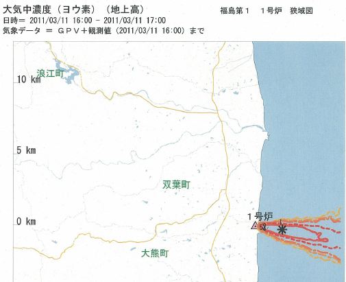
The only SPEEDI data for Fukushima they ever released are the regional radiation dispersion maps. This first one is from shortly after the EQ and tsunami hit and shows I-131 activity. It clearly shows a plume of I-131 already being emitted from the plant and blowing out to sea. The only explanation for this plume is exposed fuel.
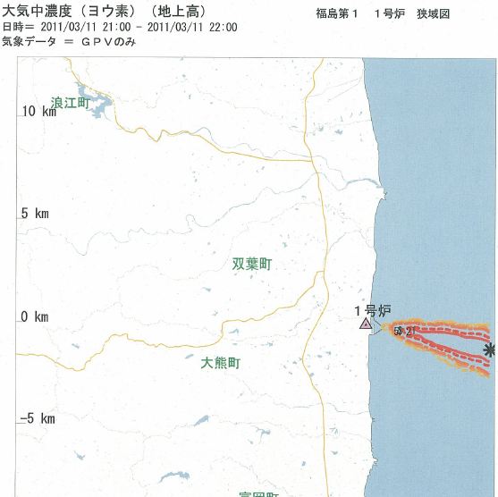
10PM on the 11th after notifying governments that there may be a problem.
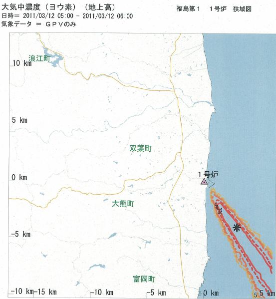
5PM on the 12th
SPEEDI takes readings from the ground and uses wind forecasts to simulate dispersion. Their data clearly show a nuclear power plant bleeding nuclides into the ocean atmosphere within minutes after the tsunamis struck.
The above quoted excerpt indicates that radioactive releases were already occurring prior to any explosion. That being the case, there is every possibility that the damage to the reactors was worse than reported much sooner than reported.
In my thread on Scientists test sick Alaska seals for radiation there are indications of some art of environmental factors affecting several different species (seals, walruses, and noe polar bears) with symptoms that mimic radiation sickness in humans.
However, no radionuclides have been found in any tissue samples. On the other hand, the only tests being performed were for isotopes of cesium (see emails between myself and theines of the scientists quoted in the news article) and there have been quite a few other radioactive contaminants released which would not show in the tests for cesium.
I'm curious why the Japanese didn't clean up and do something with these ships? Why just let them float out there as if they have no responsibility
to it?
Makes me glad that I'm landlocked and while I love seafood and fish I don't eat much of it. I make it a point not to eat seafood here in Colorado because the majority of it is frozen and icky. Fresh seafood in Colorado is a rare thing. LOL I'll stick to my rainbow trout from the near by river thanks. Although stocking up on iodine may not be such a terrible thing. LOL
Makes me glad that I'm landlocked and while I love seafood and fish I don't eat much of it. I make it a point not to eat seafood here in Colorado because the majority of it is frozen and icky. Fresh seafood in Colorado is a rare thing. LOL I'll stick to my rainbow trout from the near by river thanks. Although stocking up on iodine may not be such a terrible thing. LOL
reply to post by Xterrain
All that from a txt message? Impressive.
Anything at all to backup this particular claim?
All that from a txt message? Impressive.
Anything at all to backup this particular claim?
Originally posted by ommadawn
reply to post by Xterrain
All that from a txt message? Impressive.
Anything at all to backup this particular claim?
I'd like to AT LEAST see a photo of the alleged text message, so we can discern if the OP is intentionally hoaxing us, or if he is just spreading a rumor from someone else.
Busted not a nuclear ship. Geez why not scare more people, with idiotic research.
2nd line.
2nd line.
Back in the '70s I worked at the downtown San Diego YMCA and ran into a lot of sailors. One of them told me an interesting tale. He said one of the
big aircraft carriers had a damaged, worn out, or contaminated reactor on board, so they just towed the whole ship out to sea and dumped the entire
nuclear reactor right into the ocean. Come to think of it, does anybody know exactly how the US Navy decommissions one of their nuclear reactors?
Hell, the entire Pacific Ocean has probably been contaminated by radioactive particles for decades.
edit on 29-4-2012 by starviego because: (no
reason given)
Originally posted by MaMaa
I'm curious why the Japanese didn't clean up and do something with these ships? Why just let them float out there as if they have no responsibility to it?
Makes me glad that I'm landlocked and while I love seafood and fish I don't eat much of it. I make it a point not to eat seafood here in Colorado because the majority of it is frozen and icky. Fresh seafood in Colorado is a rare thing. LOL I'll stick to my rainbow trout from the near by river thanks. Although stocking up on iodine may not be such a terrible thing. LOL
Hi ma,
I think the Japanese have enough to deal with at home. Also the Pacific is huge. The ship most likly was not sending out any beacon for location.I think it was dumb to sink the ship. But you know like the ATF, always looking for target practice.
Also did you ever see any of the Tsunami vids? there were a lot of boats that went missing.
cheersljb
edit on 4/29/2012 by longjohnbritches because: sp
new topics
-
OK this is sad but very strange stuff
Paranormal Studies: 1 hours ago -
Islam And A Book Of Lies
Religion, Faith, And Theology: 3 hours ago -
Sorry to disappoint you but...
US Political Madness: 5 hours ago -
Watch as a 12 million years old Crab Emerges from a Rock
Ancient & Lost Civilizations: 10 hours ago
top topics
-
Sorry to disappoint you but...
US Political Madness: 5 hours ago, 13 flags -
Just Sick of It! Done! Can't take it anymore!
General Chit Chat: 17 hours ago, 9 flags -
ILLUMINATION: Dimensions / Degrees – Da Vincis Last Supper And The Philosophers Stone
Secret Societies: 16 hours ago, 9 flags -
Watch as a 12 million years old Crab Emerges from a Rock
Ancient & Lost Civilizations: 10 hours ago, 9 flags -
OK this is sad but very strange stuff
Paranormal Studies: 1 hours ago, 4 flags -
Islam And A Book Of Lies
Religion, Faith, And Theology: 3 hours ago, 1 flags
active topics
-
Musk calls on King Charles III to dissolve Parliament over Oldham sex grooming gangs
Mainstream News • 179 • : NoCorruptionAllowed -
What Is 'Quad Demic'? Mask Mandate Returns In These US States
Diseases and Pandemics • 39 • : AdultMaleHumanUK -
Meta Llama local AI system is scary good
Science & Technology • 38 • : glend -
Sorry to disappoint you but...
US Political Madness • 13 • : nugget1 -
OK this is sad but very strange stuff
Paranormal Studies • 2 • : Ravenwatcher -
Winter Storm
Fragile Earth • 33 • : rickymouse -
Stuck Farmer And His Queue Jumping Spawn
Rant • 5 • : rickymouse -
Speaking of Pandemics
General Conspiracies • 4 • : rickymouse -
Trump's idea to make Canada the 51st US state: 'Potential is massive'
Mainstream News • 154 • : WeMustCare -
DONALD J. TRUMP - TIME's Most Extraordinary Person of the Year 2024.
Mainstream News • 62 • : WeMustCare


