It looks like you're using an Ad Blocker.
Please white-list or disable AboveTopSecret.com in your ad-blocking tool.
Thank you.
Some features of ATS will be disabled while you continue to use an ad-blocker.
share:
Because I am a lazy slug, I missed that one in Memphis
I think I awakened at 8:00.....I am about 35 miles east of the epicenter.
And Puterman......I was thinking a little warmer and way more bumpy.
I think I awakened at 8:00.....I am about 35 miles east of the epicenter.
And Puterman......I was thinking a little warmer and way more bumpy.
edit on 29-10-2012 by radpetey because: (no reason given)
reply to post by PuterMan
What is all that other stuff on that seismo??
There is a huge train yard very close to there. I am assuming that is what all that scribble might be.
What is all that other stuff on that seismo??
There is a huge train yard very close to there. I am assuming that is what all that scribble might be.
reply to post by radpetey
The top one certainly looks like what I have come to recognise as train signatures. (On HBAR) The other are probably as well but fainter.
Can you give me a location for the train yard? It would be quite handy to have that marked in GE for future 'earthquakes'.
The top one certainly looks like what I have come to recognise as train signatures. (On HBAR) The other are probably as well but fainter.
Can you give me a location for the train yard? It would be quite handy to have that marked in GE for future 'earthquakes'.
edit on 29/10/2012 by PuterMan because: (no reason given)
reply to post by PuterMan
On the FCAR siesmo there's a quake at 06:20ish UTC. It shows up on HHAR and LCAR as well. I'm pretty sure it's somewhere in Ark or maybe Okie. They haven't listed it yet.
Full moon. High tide and a little low pressure system travelling up the eastern seaboard and then onto the Great Lakes and down the St. Lawerence. If the weather, and if the pressure have influences on things, then the 3.9 M should be followed by other eastern quakes in a bit of a cluster. Now, people may call me a fool for even suggesting that the Arkansas has anthing to do with anything. But, if you look at the siemos you'll see micro-siesms. and, the eastern U.S. and the Great Lakes region have gotten a load of rain the past weeks after a drought. The Mississippi itself will be filling up with the overflow. Even the areas around Lake Huron have been water logged and flash floods have hit Wawa Ontario. So, water levels after the spring were very low. Then after August, the rains returned with a vengence. If nothing else, that's lots of shifty water.
I don't have much to add on the British Columbia earthquakes. Except to note a strange coincidence. The island of Haida Gwaii doesn't often make the news. But, in the span of two weeks, it's had two big news stories. If you missed the other story, some idiots dumped a bunch of iron in the water in a so called, "experiment". I'm not suggesting they have anything to do with each other. Or, am I?
had to add
There has been another eastern quake. North Carolina 2.9M
earthquake.usgs.gov...
I don't think it's a frackquake. And it's not the earlier quake I was looking for. That one is still AWOL. Meaning there's been three quakes in east in last 10ish hours. North Carolina would be a stronger candidate for weather influenced earthquakes. I'm sure they're rain-soaked.
On the FCAR siesmo there's a quake at 06:20ish UTC. It shows up on HHAR and LCAR as well. I'm pretty sure it's somewhere in Ark or maybe Okie. They haven't listed it yet.
Full moon. High tide and a little low pressure system travelling up the eastern seaboard and then onto the Great Lakes and down the St. Lawerence. If the weather, and if the pressure have influences on things, then the 3.9 M should be followed by other eastern quakes in a bit of a cluster. Now, people may call me a fool for even suggesting that the Arkansas has anthing to do with anything. But, if you look at the siemos you'll see micro-siesms. and, the eastern U.S. and the Great Lakes region have gotten a load of rain the past weeks after a drought. The Mississippi itself will be filling up with the overflow. Even the areas around Lake Huron have been water logged and flash floods have hit Wawa Ontario. So, water levels after the spring were very low. Then after August, the rains returned with a vengence. If nothing else, that's lots of shifty water.
I don't have much to add on the British Columbia earthquakes. Except to note a strange coincidence. The island of Haida Gwaii doesn't often make the news. But, in the span of two weeks, it's had two big news stories. If you missed the other story, some idiots dumped a bunch of iron in the water in a so called, "experiment". I'm not suggesting they have anything to do with each other. Or, am I?
edit on 29-10-2012 by ericblair4891 because: (no reason given)
had to add
There has been another eastern quake. North Carolina 2.9M
earthquake.usgs.gov...
I don't think it's a frackquake. And it's not the earlier quake I was looking for. That one is still AWOL. Meaning there's been three quakes in east in last 10ish hours. North Carolina would be a stronger candidate for weather influenced earthquakes. I'm sure they're rain-soaked.
edit on 29-10-2012 by ericblair4891 because: (no reason given)
reply to post by PuterMan
I looked for a map, but did not find one....gotta go to work.
It is North and a little west of W. Memphis, Ar.. Just west of I-55, running parallel to hwy. 64.
Will find a map tonight when I come back from the grind!
Here is a story about a newly discovered fault(not New Madrid) that is capable of producing a 7+.
I believe this 3.9 happened on this fault line.......maybe!
www.katv.com...
edit on 29-10-2012 by radpetey because: (no reason given)
reply to post by ericblair4891
I am not sure that is an earthquake in my opinion. Signature is all wrong in the spectro and too high. There is no clear double thump. If this was a small local quake I would expect a pop pop to be audible but at normal speeds that I use (10 x) there is nothing. If I whack it up to 80 times speed however I can hear what could be a P and S wave so not sure.
Sounds more like..........lightening? tunnel boring? ( )
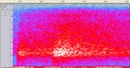
All the action is above 10 Hz which I think is unlikely for a local quake. I would expect to see a signal between 5 and 10 tapering off up to 15. Normally on a quake you get around 5 Hz for the P and then it drops, often to 1 or 2 as the S rolls by.
Here is a perfect example of what I am trying to show in words.
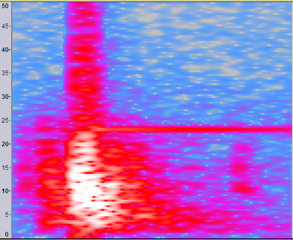
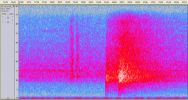
Now this one we are talking about is not the same at all. No drop, all at 10 Hz or above. Note there are 2 little blips just before this? Those sound electrical at higher speed. Could this be lightening and thunder???
I am not sure that is an earthquake in my opinion. Signature is all wrong in the spectro and too high. There is no clear double thump. If this was a small local quake I would expect a pop pop to be audible but at normal speeds that I use (10 x) there is nothing. If I whack it up to 80 times speed however I can hear what could be a P and S wave so not sure.
Sounds more like..........lightening? tunnel boring? ( )

All the action is above 10 Hz which I think is unlikely for a local quake. I would expect to see a signal between 5 and 10 tapering off up to 15. Normally on a quake you get around 5 Hz for the P and then it drops, often to 1 or 2 as the S rolls by.
Here is a perfect example of what I am trying to show in words.

Now this one we are talking about is not the same at all. No drop, all at 10 Hz or above. Note there are 2 little blips just before this? Those sound electrical at higher speed. Could this be lightening and thunder???

reply to post by PuterMan
If it's a sound, then it was registered on at least those three AG stations and I've found at least one in Missouri.
I don't think it was lightning because I've been watching the storms and I don't think that area even had cloud cover. Does it look like a sonic boom?
folkworm.ceri.memphis.edu...
So, whatever it was, it was picking up in a roughly two hundred kilometer radius around with the center somwhere near the Arkansas Missouri border.
edit on 29-10-2012 by ericblair4891 because: (no reason given)
reply to post by Aircooled
Canada's JSON file finally caught up. A whole load of quakes from yesterday came in just now.
As I suspected they check things out first like they do at Yellowstone.
Canada's JSON file finally caught up. A whole load of quakes from yesterday came in just now.
As I suspected they check things out first like they do at Yellowstone.
reply to post by ericblair4891
Well I would say not, but my guess is based on those that were identified by PNSN as booms and they are very tall spikes (I will look one out in a moment).
I am not categorically stating that it was not an earthquake, just really saying that it does not have the attributes that I normally associate with earthquakes when looking at them with the (unsophisticated) tools I use.
Oh!!!!!!!!! I just went to look up the time in my list to see if I could see anything and
Location in Google Maps
Derived from Event Data Source: USGS
Powered by QVSData
So congratulations, looks like you were right. (Now I need to try and work out why that looked so different)
I am guessing that because it was pretty shallow the signal was not attenuated much and thus the higher component did not get dropped down by it's passage through the earth. Something to remember for the future so thanks for pointing me in that direction.
ETA: Um, nope looks as if it is not that since the U41A has all the right attributes.
I had this pegged as between U41A and U42A which it was yet I looked at HHAR and then stopped. My error. Had I gone to look at U41A first I would have seen this:
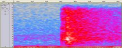
Now that IS an earthquake. Look at the bulk of the signal in between 2 Hz and 5 Hz and the slight drop over the period form P to S.
Interesting that on the waveform you can also see the storm in the Atlantic
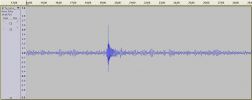
Nice sound on this little one as well (Zip download)
TA_U41A FLAC file (WinAmp plays these)
Does it look like a sonic boom?
Well I would say not, but my guess is based on those that were identified by PNSN as booms and they are very tall spikes (I will look one out in a moment).
I am not categorically stating that it was not an earthquake, just really saying that it does not have the attributes that I normally associate with earthquakes when looking at them with the (unsophisticated) tools I use.
Oh!!!!!!!!! I just went to look up the time in my list to see if I could see anything and
Magnitude 2.4 - Southeastern Missouri
Location in Google Maps
- Date-Time: Monday, October 29, 2012 @ 06:19:10 UTC
- Earthquake location: 36.603°N, 91.657°W,
- Earthquake depth: 2.1 km
- Distances:
13km (8mi) NW of Thayer, Missouri
22km (13mi) SE of West Plains, Missouri
71km (44mi) ENE of Mountain Home, Arkansas
92km (57mi) N of Batesville, Arkansas
213km (132mi) NNE of Little Rock, Arkansas
- Event ID: nm102912c
Derived from Event Data Source: USGS
Powered by QVSData
So congratulations, looks like you were right. (Now I need to try and work out why that looked so different)
I am guessing that because it was pretty shallow the signal was not attenuated much and thus the higher component did not get dropped down by it's passage through the earth. Something to remember for the future so thanks for pointing me in that direction.
ETA: Um, nope looks as if it is not that since the U41A has all the right attributes.
I had this pegged as between U41A and U42A which it was yet I looked at HHAR and then stopped. My error. Had I gone to look at U41A first I would have seen this:

Now that IS an earthquake. Look at the bulk of the signal in between 2 Hz and 5 Hz and the slight drop over the period form P to S.
Interesting that on the waveform you can also see the storm in the Atlantic

Nice sound on this little one as well (Zip download)
TA_U41A FLAC file (WinAmp plays these)
edit on 29/10/2012 by PuterMan because: (no reason given)
What do you all think of the quake action that has been going on in the Western Yukon territory in Canada??
earthquake.usgs.gov...
If you look at the map I have linked, you can almost imagine that the fault that ends at the Canadian land mass would continue right up and through the area that has had all the quakes in the last 3 weeks.
Was that sentence long enough for you?(grammar and sentence structure not my forte).
Anyway, could these smaller quakes in the Yukon and the big one that just happened be connected in any way??
edit on 29-10-2012 by radpetey
because: (no reason given)
reply to post by radpetey
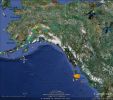
OK who stole the text? Come on, own up.
Yes they probably are connected after all they are just round the corner and on the plate boundary.

OK who stole the text? Come on, own up.
Yes they probably are connected after all they are just round the corner and on the plate boundary.
edit on 29/10/2012 by PuterMan because: This post received green decoration becuase someone stole the text I had written. Stealing text really
is not very nice and I would ask the perpetrator to kindly desist.
reply to post by PuterMan
Thanks for that detailed picture. It answers me question!
The fault hangs a hard left and goes back out to see.....probably not related.
Thanks for that detailed picture. It answers me question!
The fault hangs a hard left and goes back out to see.....probably not related.
Could 941 millibars be enough to cause some shaking on the East coast??
I guess we will have to wait and see....I have linked an interesting article about the fault system in and around NYC.
Enjoy!
en.wikipedia.org...
I guess we will have to wait and see....I have linked an interesting article about the fault system in and around NYC.
Enjoy!
en.wikipedia.org...
I've been watching too much weather news. I'm a weather geek. And I'm watching too much wavy lines on the siesmos. They're making me sea sick. What a
night though. I definately feel alive. I keep waiting for a tree to com through the window as the northeastern beats down on us. Something just went
boom outside. Oh, well.
I read a report that the waves on Lake Huron and on Lake Michigan were going to be up around 25 feet. The wind will be pushing down from the north and the wave will be hitting the south end near Chicago. Pretty dramatic. The siesmos are showing lots of micro-siesms as Puterman noted. One in particular caught my eye because it's pretty far inland and so I didn't think it wouldn't be showing up there so pronounced. But no. It was. I check Minnestoa they're realtively calm. The staion in Illinois was in a city called Hopedale. Hopedale, Illinois. If anyone is inclined, please look at it on google maps. If there's nothing out of the ordinary there, say nothing. If you have any other thoughts, please share. Just a curiousity or a (crash boom bang outside) Halloweeny pre-jitter.
Right now I'm going to stop watching the weather networks. I'll stop checking the wiggly lines so much. And I'll relax and watch PBS's American Experience showing of the Hurricane of '38. Hey, I'm not feeding my weather geek need. I'll be watching it because I'm a history geek as well.
Puterman. I was right about that quake despite the fact my tools are much more less sophisticated than yours. It's me eyeball is all. And no need for congratulations. Please save them for the day the yo-yos stop being yo-yos and recognize my moon theory is correct and the earth birthed the baby moon. No collision. And it was giant phreatic volcanoes that did it. Darwin was right. But the earth didn't fling off some material. It was ejected into existence- just as just about anything is born.
Once a mama cat woke me up by having kittens on my chest. I was in a dead sleep. I awoke to find a white persian long haired cat spinning around in circles on top of me. I was very groggy and confused, still in a dream I suppose. The cat let out a very distressing howl and became frantic and spun in a frenzy. Before I had a clue, a kitten plopped out and landed right in my chest and arms. It was graphic. It was like a bad B-movie I had watched once. I think it was called Uncanny. I was horrified. It would have helped if it was my cat but it wasn't. I just somehow became a surragote midwife. Sorry. Just thought I'd share a spooky, creepy story. No good ending, other than it was true. The kittens were fine and I took care of mama. But obviously the scence was so shocking it's etched in my mind.
Right- Hurricane of '38
Forgot to add Hopeland's siesmo
folkworm.ceri.memphis.edu...
edit on 29-10-2012 by ericblair4891 because: (no reason given)
6.2 just happened in the same spot as the 7.7 (Masset,Canada)!
edit on 10/29/12 by Evildead because: (no reason given)
Originally posted by Hydrawolf
6.2 Canada
earthquake.usgs.gov...
Another one, mag 5.0
quakes.globalincidentmap.com...
Haida Gwaii (formerly Queen Charlotte Islands)
Prov,Date/Time UTC,Latitude,Longitude,Magnitude,Depth(Km),Location
[color=38ACEC]emsc,2012-10-30 02:49:06, 52.224, -131.985, [color=38ACEC]5.7mb, 40.0, Queen Charlotte Isls. Region
gfz,2012-10-30 02:49:03, 52.210, -132.020, 6.1M, 10.0, Queen Charlotte Isls. Region
[color=157DEC]usgs,2012-10-30 02:49:02, 52.315, -132.208, [color=157DEC]5.8mb, 15.0, Queen Charlotte Isls. Canada Region
ras,2012-10-30 02:49:00.3,52.27,-131.99, 6.1mb, 10.0, Queen Charlotte Islands region
edit on 30-10-2012 by muzzy because: brightened it up a bit
Could someone help ease some of my concerns?
There has been a lot of activity along the fault lines of the Pacific Plate. It seems like so far only the southern most faults have not seen much activity but the north section of the plate is a hotbed of EQs and aftershocks. Is this normal plate behaviour?
There has been a lot of activity along the fault lines of the Pacific Plate. It seems like so far only the southern most faults have not seen much activity but the north section of the plate is a hotbed of EQs and aftershocks. Is this normal plate behaviour?
new topics
-
Tariffs all around, Except for ...
Predictions & Prophecies: 1 hours ago -
Gen Flynn's Sister and her cohort blow the whistle on DHS/CBP involvement in child trafficking.
Whistle Blowers and Leaked Documents: 6 hours ago -
Anybody else using Pomodoro time management technique?
General Chit Chat: 9 hours ago -
Bucks County commissioners vote to count illegal ballots in Pennsylvania recount
2024 Elections: 11 hours ago
top topics
-
Trump sues media outlets -- 10 Billion Dollar lawsuit
US Political Madness: 12 hours ago, 24 flags -
Bucks County commissioners vote to count illegal ballots in Pennsylvania recount
2024 Elections: 11 hours ago, 21 flags -
How long till it starts
US Political Madness: 14 hours ago, 17 flags -
USSS Agent Fired for Having Sex In Michelle Obama's Bathroom
Politicians & People: 15 hours ago, 10 flags -
Fired fema employee speaks.
US Political Madness: 12 hours ago, 10 flags -
Gen Flynn's Sister and her cohort blow the whistle on DHS/CBP involvement in child trafficking.
Whistle Blowers and Leaked Documents: 6 hours ago, 8 flags -
Anybody else using Pomodoro time management technique?
General Chit Chat: 9 hours ago, 3 flags -
Tariffs all around, Except for ...
Predictions & Prophecies: 1 hours ago, 1 flags
active topics
-
President-Elect DONALD TRUMP's 2nd-Term Administration Takes Shape.
Political Ideology • 205 • : WeMustCare -
On Nov. 5th 2024 - AMERICANS Prevented the Complete Destruction of America from Within.
2024 Elections • 155 • : WeMustCare -
Mike Tyson returns 11-15-24
World Sports • 53 • : Blueracer -
The Trump effect 6 days after 2024 election
2024 Elections • 143 • : cherokeetroy -
Bucks County commissioners vote to count illegal ballots in Pennsylvania recount
2024 Elections • 21 • : Irishhaf -
Tariffs all around, Except for ...
Predictions & Prophecies • 6 • : gort69 -
60s-70s Psychedelia
Music • 54 • : gort69 -
The art of being offended
Social Issues and Civil Unrest • 49 • : gort69 -
Gen Flynn's Sister and her cohort blow the whistle on DHS/CBP involvement in child trafficking.
Whistle Blowers and Leaked Documents • 6 • : gort69 -
How long till it starts
US Political Madness • 17 • : WeMustCare
