It looks like you're using an Ad Blocker.
Please white-list or disable AboveTopSecret.com in your ad-blocking tool.
Thank you.
Some features of ATS will be disabled while you continue to use an ad-blocker.
share:
reply to post by SCGrits
Hi!
Thanks for that map link.
I was looking all over for it earlier today when I saw the NY one listed.
It disappeared from my favorites bar!
EarthScope ANF still doesn't have it on their map!
We had touched on the possible hurricane / earthquake connection last year I think it was.
I think it was 1938?, when there was an east coast hurricane & a northeast quake fairly close together.
Maybe Eric remembers? My memory was the first thing to go!
I'd do some digging, but it's 1 a.m. here!
Peace, out!
WOQ
edit on 1-7-2012 by wasobservingquietly because: It's late & I'm tired, shat happens!
reply to post by steve95988
I was just looking at this too and debating about whether or not to post it. Thanks for doing it for me! Let's hope they don't get any bigger.
I was just looking at this too and debating about whether or not to post it. Thanks for doing it for me! Let's hope they don't get any bigger.
Originally posted by TMG333
reply to post by steve95988
I was just looking at this too and debating about whether or not to post it. Thanks for doing it for me! Let's hope they don't get any bigger.
I have a cpl gee stations up in that area... the only worrisome thing is that its continuing, with minor to moderate quakes... could be getting ready to give a good slip strike quake in that area,,, needless to say imma watch this for another hour or so
reply to post by steve95988
Good to know somebody is keeping an eye on things at this time of night. The last real good shaker I felt around here came from the 7.2 down there back in April 2010. Nothing really of note since then.
Good to know somebody is keeping an eye on things at this time of night. The last real good shaker I felt around here came from the 7.2 down there back in April 2010. Nothing really of note since then.
And not just in Baja. Biggest yet at El Hierro
Location map by EMSC (Google Map)
Derived from Event Data Source: EMSC
Powered by QVSData
'puter crashed!
I have now updated my blog page for El Hierro (see my signature)
Magnitude 4.2 - Canary Islands Spain Region
Location map by EMSC (Google Map)
- Date-Time: Sunday, July 01, 2012 @ 10:11:40 UTC
- Earthquake location: 27.660°N, 18.127°W,
- Earthquake depth: 22.0 km
- Distances:
1202 km SW Casablanca (pop 3,144,909 ; local time 10:11:40.9 2012-07-01)
200 km SW San cristóbal de la laguna (pop 139,928 ; local time 11:11:40.9 2012-07-01)
112 km S Los llanos de aridane (pop 19,635 ; local time 11:11:40.9 2012-07-01)
93 km SW Valle gran rey (pop 4,983 ; local time 11:11:40.9 2012-07-01)
- Event ID: 276235
Derived from Event Data Source: EMSC
Powered by QVSData
'puter crashed!
I have now updated my blog page for El Hierro (see my signature)
edit on 1/7/2012 by PuterMan because: (no reason given)
reply to post by westcoast
I just loaded up the graphs because I thought I would take a look before opening a blog page for any forthcoming event and.......
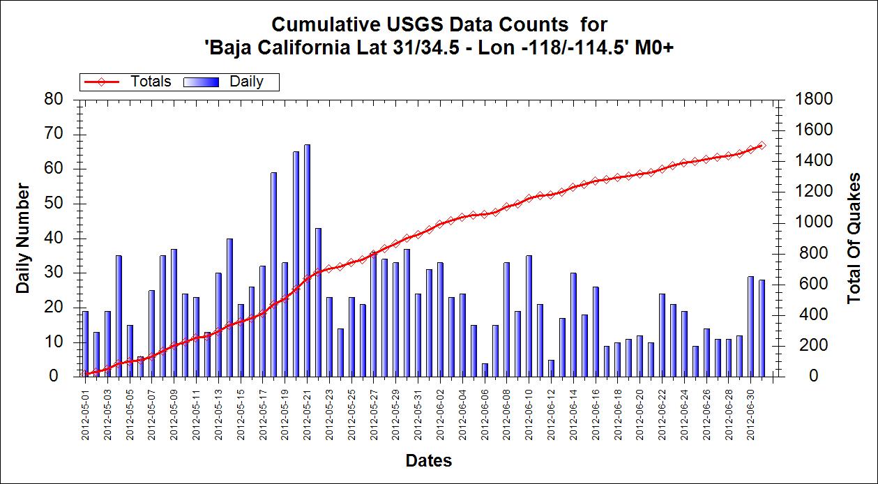
...it looks as if there were more in May in terms of numbers.check the energy as well and report back but other than that this does not seem to be an impending event.
OK here is the current list. Today is the biggest in terms of energy
Another proof that numbers do not really matter. Here is the energy chart with today being massively more than over the same period as the numbers.
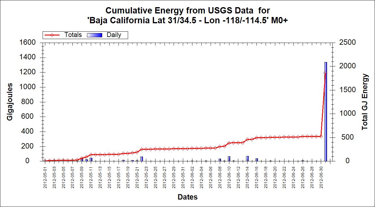
Yup guess something is going on.
I just loaded up the graphs because I thought I would take a look before opening a blog page for any forthcoming event and.......

...it looks as if there were more in May in terms of numbers.check the energy as well and report back but other than that this does not seem to be an impending event.
OK here is the current list. Today is the biggest in terms of energy
Prov,Date/Time UTC,Latitude,Longitude,Magnitude,Depth(Km),Location
usgs,2012-07-01 12:07:11, 32.202, -115.296, 2.3, 1.3, Baja California. Mexico
usgs,2012-07-01 11:59:49, 32.203, -115.280, 2.1, 0.0, Baja California. Mexico
usgs,2012-07-01 11:57:22, 32.177, -115.268, 2.5, 0.2, Baja California. Mexico
usgs,2012-07-01 11:52:16, 32.198, -115.288, 2.4, 1.3, Baja California. Mexico
usgs,2012-07-01 11:49:16, 32.182, -115.262, 2.8, 0.1, Baja California. Mexico
usgs,2012-07-01 11:24:29, 32.198, -115.291, 3.0, 0.0, Baja California. Mexico
usgs,2012-07-01 10:22:19, 32.192, -115.284, 2.7, 0.0, Baja California. Mexico
usgs,2012-07-01 09:50:39, 32.205, -115.254, 2.3, 0.0, Baja California. Mexico
usgs,2012-07-01 08:41:02, 32.183, -115.275, 2.3, 0.0, Baja California. Mexico
usgs,2012-07-01 08:39:38, 32.130, -115.283, 2.5, 8.1, Baja California. Mexico
usgs,2012-07-01 08:10:18, 32.193, -115.311, 2.7, 0.1, Baja California. Mexico
usgs,2012-07-01 08:08:29, 32.176, -115.283, 2.6, 18.8, Baja California. Mexico
usgs,2012-07-01 08:06:32, 32.202, -115.299, 2.7, 0.2, Baja California. Mexico
usgs,2012-07-01 07:54:20, 32.180, -115.270, 4.1, 10.0, Baja California. Mexico
usgs,2012-07-01 06:58:14, 32.201, -115.267, 2.5, 0.7, Baja California. Mexico
usgs,2012-07-01 06:49:58, 32.163, -115.250, 3.5, 0.1, Baja California. Mexico
usgs,2012-07-01 06:49:07, 32.160, -115.281, 3.0, 3.5, Baja California. Mexico
usgs,2012-07-01 06:36:06, 32.213, -115.288, 4.7, 10.0, Baja California. Mexico
usgs,2012-07-01 06:29:18, 32.163, -115.291, 2.8, 1.1, Baja California. Mexico
usgs,2012-07-01 05:52:41, 32.180, -115.300, 3.4, 0.9, Baja California. Mexico
usgs,2012-07-01 04:28:29, 32.209, -115.336, 2.5, 12.6, Baja California. Mexico
usgs,2012-07-01 03:33:47, 32.181, -115.310, 3.5, 10.0, Baja California. Mexico
usgs,2012-07-01 03:25:21, 32.252, -115.330, 4.6, 10.0, Baja California. Mexico
usgs,2012-06-30 22:05:59, 32.530, -116.257, 1.7, 17.0, Baja California. Mexico
usgs,2012-06-28 18:19:29, 31.271, -115.581, 2.2, 5.4, Baja California. Mexico
usgs,2012-06-27 12:07:08, 32.396, -115.447, 2.3, 6.8, Baja California. Mexico
usgs,2012-06-26 14:34:03, 32.217, -115.280, 3.1, 8.3, Baja California. Mexico
usgs,2012-06-26 11:33:19, 32.152, -115.740, 2.2, 10.0, Baja California. Mexico
usgs,2012-06-24 19:26:41, 32.244, -115.278, 1.7, 10.0, Baja California. Mexico
usgs,2012-06-24 18:22:56, 32.413, -115.207, 2.4, 0.1, Baja California. Mexico
usgs,2012-06-24 03:25:41, 32.231, -115.275, 2.6, 10.0, Baja California. Mexico
Another proof that numbers do not really matter. Here is the energy chart with today being massively more than over the same period as the numbers.

Yup guess something is going on.
edit on 1/7/2012 by PuterMan because: (no reason given)
reply to post by PuterMan
Really nice graphical comparison, Puterman. Thanks. Also. the depths seem to have migrated closer to the surface.
Changing locations, the deformation over the last 2 weeks on El Hierro is impressive. Graphs
Between that and the earthquake swarms, I would be nervous if I lived there.
Really nice graphical comparison, Puterman. Thanks. Also. the depths seem to have migrated closer to the surface.
Changing locations, the deformation over the last 2 weeks on El Hierro is impressive. Graphs
Between that and the earthquake swarms, I would be nervous if I lived there.
edit on 7/1/2012 by Olivine because: (no reason given)
reply to post by Olivine
What is really weird is that today it stopped dead!
The 4.2 I reported earlier, then a 2.5 2 minutes later and that is it - unless EMSC has gone down - it just ground to halt.
Yes it pretty much stopped. Only very small stuff
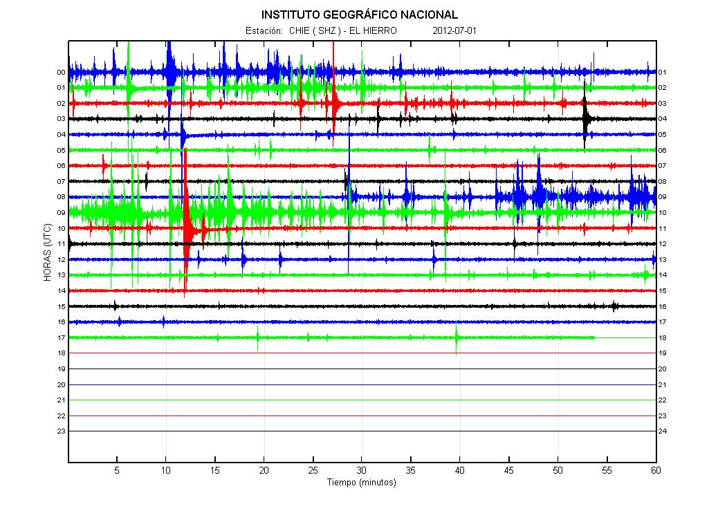
What is really weird is that today it stopped dead!
Prov,Date/Time UTC,Latitude,Longitude,Magnitude,Depth(Km),Location
emsc,2012-07-01 10:13:36, 27.681, -18.125, 2.5, 20.0, Canary Isls. Spain Region
emsc,2012-07-01 10:11:40, 27.660, -18.126, 4.2, 22.0, Canary Isls. Spain Region
emsc,2012-07-01 09:48:39, 27.658, -18.155, 2.7, 22.0, Canary Isls. Spain Region
The 4.2 I reported earlier, then a 2.5 2 minutes later and that is it - unless EMSC has gone down - it just ground to halt.
Yes it pretty much stopped. Only very small stuff

edit on 1/7/2012 by PuterMan because: (no reason given)
reply to post by PuterMan
seen the original type of phenom. in California,, the Caflifornia Wiggle,
same wiggle different area.
called riding the dragon,, lol
or magma Wave Sine Pattern numb. #CA1a,,see Magma/EarthTremor Wavefreq. Chart xxxx
seen the original type of phenom. in California,, the Caflifornia Wiggle,
same wiggle different area.
called riding the dragon,, lol
or magma Wave Sine Pattern numb. #CA1a,,see Magma/EarthTremor Wavefreq. Chart xxxx
reply to post by PuterMan
seems to something below collapsed ...relieving the stress,,,,until that cavity is filled up again...
btw... are iceland and the canary's connected somehow ???
last year with the undersea volcano swarm... katla also sufferd an swarm.....
seems to something below collapsed ...relieving the stress,,,,until that cavity is filled up again...
btw... are iceland and the canary's connected somehow ???
last year with the undersea volcano swarm... katla also sufferd an swarm.....
reply to post by PuterMan
Wow...I just love your graphs and how it puts it all into perspective. Looks like they're still rocking down there. I hope it isn't leading up to a bigger event.
As far as the canary Islands...that IS a lot of movement. I don't know if the relative silence all of a sudden is a good or bad thing.
Wow...I just love your graphs and how it puts it all into perspective. Looks like they're still rocking down there. I hope it isn't leading up to a bigger event.
As far as the canary Islands...that IS a lot of movement. I don't know if the relative silence all of a sudden is a good or bad thing.
Still pretty quiet down here in NZ, only thing to report is a couple of unusual locations, not seen on a regular basis, maybe once/twice a year, if
that
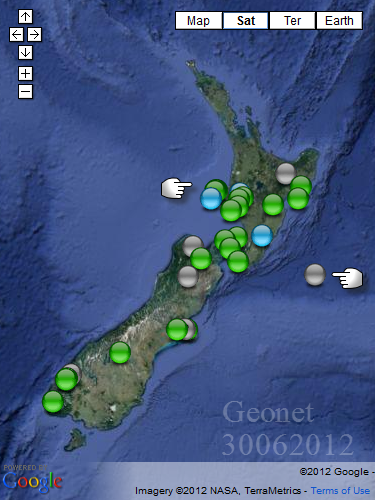
small Swarm off New Plymouth
closer interactive map of the New Plymouth swarm
Location has the potential for a 6.8, been a while though
Cape Egmont earthquake events 1853 to Dec 31st 2007 incl interactive map
And the other one out on the Pacific Plate

small Swarm off New Plymouth
2.766, 3731463, -39.01108, 173.97739, 2012/6/30 19:2:30.4, 7, os NW of Port Taranaki
2.695, 3731491, -39.0151, 173.9552, 2012/6/30 20:11:3.7, 10, os NW of Port Taranaki
2.914, 3731506, -39.0058, 174.00661, 2012/6/30 20:53:4.3, 5, os NW of Port Taranaki
2.669, 3731508, -38.99781, 173.99547, 2012/6/30 20:56:48.1, 5, os NW of Port Taranaki
2.767, 3731513, -39.00837, 173.98584, 2012/6/30 21:5:34.7, 8, os NW of Port Taranaki
closer interactive map of the New Plymouth swarm
Location has the potential for a 6.8, been a while though
2178013, -39, 174, 1853/1/1 8:45, 6.8ML
2178063, -39, 174, 1868/10/26, 6.0ML
Cape Egmont earthquake events 1853 to Dec 31st 2007 incl interactive map
And the other one out on the Pacific Plate
3.41, 3731220, -41.80896, 178.33432, 2012/6/30 7:5:41.6, 33, os N of the North Chatham Slope, E of Cook Strait
edit on 1-7-2012 by muzzy because: got some tags wrong and altered the NP list so the lines fitted in the pathetically narrow confines of the
post window
reply to post by kdog1982
Thank you for quoting it, I just wish staff to stop with this baseless, artificial member count-inflating practice.
reply to post by sad_eyed_lady
update
155,000 people affected after Xinjiang quake
English.news.cn 2012-07-01 21:40:38
news.xinhuanet.com/english/china/2012-07/01/c_131688118.htm
Thank you for quoting it, I just wish staff to stop with this baseless, artificial member count-inflating practice.
reply to post by sad_eyed_lady
update
155,000 people affected after Xinjiang quake
English.news.cn 2012-07-01 21:40:38
news.xinhuanet.com/english/china/2012-07/01/c_131688118.htm
URUMQI, July 1 (Xinhua) -- More than 155,000 people had been affected as of late Sunday, after a 6.6-magnitude quake jolted northwest China's Xinjiang Uygur Autonomous Region early Saturday morning, local authorities said Sunday.
As of 7 p.m. Sunday, the number of injured people climbed to 52 and 48,000 people had been evacuated after the earthquake hit a mountainous area along the border of Hejing and Xinyuan counties at 5:07 a.m., followed by several aftershocks of 3-to-4 magnitude, said authorities of the government of Ili Kazak Autonomous Prefecture.
The quakes also tore down 7,500 houses and damaged another 64,000 houses.
China's National Disaster Reduction Committee and the Ministry of Civil Affairs responded to the quakes and dispatched relief goods to quake-hit areas.
The ministry allocated 2,000 tents, 10,000 quilts and 10,000 cotton coats to the areas. The regional governments also dispatched 5.1 tonnes of flour and 480 kilograms of edible vegetable oil as well as 230 tents and 120 quilts.
The county's government had organized 2,470 people to the disaster relief work and had been trying to repair the damaged main roads.
Experts said the quake-hit region, located about 3,500 meters above sea level, has been geologically active throughout history. Two earthquakes measuring higher than 7 on the Richter scale have jolted the region since 1900.
© 2012 Xinhua, english.news.cn. All rights reserved.
edit on 1-7-2012 by ormxvvh because: (no reason given)
What the heck is going on in Baja????
The majority are shallow.
earthquake.usgs.gov...
Oh,and please tell me something of this site...
eqinfo.ucsd.edu...
The majority are shallow.
earthquake.usgs.gov...
Oh,and please tell me something of this site...
eqinfo.ucsd.edu...
edit on 1-7-2012 by kdog1982 because: (no reason given)
Originally posted by kdog1982
What the heck is going on in Baja????
The majority are shallow.
earthquake.usgs.gov...
Not a lot, add all the energy released by all those and its equal to just one 4.885ML quake
2/07/2012 1:34, 32.181, -115.26, 1.2, BAJA CALIFORNIA, MEXICO, 2.6 =0.120 TTNT
2/07/2012 0:12, 32.175, -115.336, 0.1, BAJA CALIFORNIA, MEXICO, 2.6 =0.120 TTNT
1/07/2012 22:09, 32.173, -115.266, 0.1, BAJA CALIFORNIA, MEXICO, 2.9 =0.338 TTNT
1/07/2012 21:46, 32.184, -115.322, 0.8, BAJA CALIFORNIA, MEXICO, 2.5 =0.085 TTNT
1/07/2012 20:37, 32.196, -115.27, 0, BAJA CALIFORNIA, MEXICO, 2.6 =0.120 TTNT
1/07/2012 11:57, 32.177, -115.269, 0.2, BAJA CALIFORNIA, MEXICO, 2.5 =0.085 TTNT
1/07/2012 11:49, 32.182, -115.263, 0.1, BAJA CALIFORNIA, MEXICO, 2.8 =0.239 TTNT
1/07/2012 11:24, 32.198, -115.292, 0, BAJA CALIFORNIA, MEXICO, 3 =0.477 TTNT
1/07/2012 10:22, 32.193, -115.284, 0, BAJA CALIFORNIA, MEXICO, 2.7 =0.169 TTNT
1/07/2012 8:39, 32.13, -115.284, 8.1, BAJA CALIFORNIA, MEXICO, 2.5 =0.085 TTNT
1/07/2012 8:10, 32.193, -115.311, 0.1, BAJA CALIFORNIA, MEXICO, 2.7 =0.169 TTNT
1/07/2012 8:08, 32.176, -115.283, 18.8, BAJA CALIFORNIA, MEXICO, 2.6 =0.120 TTNT
1/07/2012 8:06, 32.203, -115.299, 0.2, BAJA CALIFORNIA, MEXICO, 2.7 =0.169 TTNT
1/07/2012 7:54, 32.18, -115.27, 10, BAJA CALIFORNIA, MEXICO, 4.1 =21.301 TTNT
1/07/2012 6:58, 32.201, -115.267, 0.7, BAJA CALIFORNIA, MEXICO, 2.5 =0.085 TTNT
1/07/2012 6:49, 32.163, -115.251, 0.1, BAJA CALIFORNIA, MEXICO, 3.5 =2.682 TTNT
1/07/2012 6:49, 32.16, -115.281, 3.5, BAJA CALIFORNIA, MEXICO, 3 =0.477 TTNT
1/07/2012 6:36, 32.213, -115.289, 10, BAJA CALIFORNIA, MEXICO, 4.7 =169.203 TTNT
1/07/2012 6:29, 32.164, -115.292, 1.1, BAJA CALIFORNIA, MEXICO, 2.8 =0.239 TTNT
1/07/2012 5:52, 32.18, -115.3, 0.9, BAJA CALIFORNIA, MEXICO, 3.4 =1.898 TTNT
1/07/2012 4:28, 32.209, -115.337, 12.6, BAJA CALIFORNIA, MEXICO, 2.5 =0.085 TTNT
1/07/2012 3:33, 32.181, -115.31, 10, BAJA CALIFORNIA, MEXICO, 3.5 =2.682 TTNT
1/07/2012 3:25, 32.252, -115.33, 10, BAJA CALIFORNIA, MEXICO, 4.6 =119.787 TTNT
Total =320.733 TTNT equal to a 4.885ML
NBD (No Big Deal)
edit on 1-7-2012 by muzzy because: (no reason given)
reply to post by muzzy
I have to say I am not so sure I could make that call yet. With 3 x Mag 4 in one day that is a significant departure from the normal for the area over a short period although the energy levels have been seen before. (Feb 12, Feb 11). If you recall the 7.2 was April 2010 so in terms of time of year statistically over the past 3 years at least this comes at an odd time.
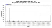
Of course it may settle back down, but until a week or so has passed at lower levels of activity I would flag this as YELLOW-AMBER on a scale of green, yellow, amber, red.
I have to say I am not so sure I could make that call yet. With 3 x Mag 4 in one day that is a significant departure from the normal for the area over a short period although the energy levels have been seen before. (Feb 12, Feb 11). If you recall the 7.2 was April 2010 so in terms of time of year statistically over the past 3 years at least this comes at an odd time.

Of course it may settle back down, but until a week or so has passed at lower levels of activity I would flag this as YELLOW-AMBER on a scale of green, yellow, amber, red.
edit on 2/7/2012 by PuterMan because: To add more "stuff" 'cos "stuff" is good.
new topics
-
Bizarre Labour Party Tic Toc Video Becomes Even More Embarrassing
Regional Politics: 1 hours ago -
Potter to WHU
World Sports: 7 hours ago -
Dr. Demento
Music: 8 hours ago -
The elephant in the room (wearing a hoodie)
US Political Madness: 8 hours ago
top topics
-
The elephant in the room (wearing a hoodie)
US Political Madness: 8 hours ago, 14 flags -
To become president, Zelensky had to learn Ukrainian
Political Conspiracies: 15 hours ago, 9 flags -
Dr. Demento
Music: 8 hours ago, 6 flags -
Bizarre Labour Party Tic Toc Video Becomes Even More Embarrassing
Regional Politics: 1 hours ago, 3 flags -
Potter to WHU
World Sports: 7 hours ago, 2 flags
active topics
-
Los Angeles brush fires latest: 2 blazes threaten structures, prompt evacuations
Mainstream News • 205 • : tarantulabite1 -
Bizarre Labour Party Tic Toc Video Becomes Even More Embarrassing
Regional Politics • 4 • : gortex -
The Truth about Migrant Crime in Britain.
Social Issues and Civil Unrest • 43 • : angelchemuel -
The Fight for Election Integrity Continues -- Audits, Criminal Investigations, Legislative Reform
2024 Elections • 4374 • : IndieA -
President Carter has passed
Mainstream News • 52 • : xuenchen -
What Comes After January 20th
Mainstream News • 37 • : xuenchen -
Potter to WHU
World Sports • 3 • : gortex -
Post A Funny (T&C Friendly) Pic Part IV: The LOL awakens!
General Chit Chat • 8007 • : underpass61 -
Planned Civil War In Britain May Be Triggered Soon
Social Issues and Civil Unrest • 29 • : AdultMaleHumanUK -
The elephant in the room (wearing a hoodie)
US Political Madness • 19 • : xuenchen
