It looks like you're using an Ad Blocker.
Please white-list or disable AboveTopSecret.com in your ad-blocking tool.
Thank you.
Some features of ATS will be disabled while you continue to use an ad-blocker.
share:
With winter now firmly in its grip here in the UK, i think it would be prudent to inform our UK members (particularly those living north of
Manchester) of an up-coming major storm for Friday 9th December into Saturday 10th December.
Before i provide a synopsis of the event, i want you all to know that this is not a "normal" winter storm, this is a very deep storm, this storm will present a danger to life in more than 1 way.
This storm will present danger to life through many factors. There will be a storm surge alone the East Coast of the UK, there will be winds possibly in excess of 100mph for northern Britain, there will be blizzards and a projected wind chill factor of below -15oC.
Since this is the festive season and there are a lot of Christmas Work Night Outs, if any of you are out and about...please wrap up warm. Don't be foolish with the short skirts and flimsy jackets.
This is a very dangerous storm and for those of you living north of Manchester, make sure you are prepared for power cuts and any structural damage.
As a side note. I am an avid weather fanatic and i don't scaremonger people about weather events. This is a real event that is serious in nature.
Be Safe...
Source
I do have synoptic charts and data graphs that i can post on this event if any of you wish to see them but using the image facility on ATS is dreadful. If anyone wants to see any of the images and model projections, let me know and i'll try to figure this out.
(There is no conspiracy here, this isn't HARRP or Chemtrails or Aliens or David Cameron, this is a notice for safety and advice that anyone wishes to share)
ETA: Here is a link to a map of the surface temperature and the wind speeds projected here
Here are a few images to help illustrate so more details. This is what your not being informed about at present, this is what the models are predicting. The Met and BBC will hold off as long as possible before upgrading their warnings, but this is some of the images they use.
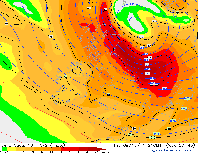
The image above illustrates the isobar chart and the severity of wind in knots. the maximum projected wind speeds are about 75-80knots which i believe is about 90mph. The isobars are closely packed with a N-NW direction of wind. As you can see, the storm surge will most likely stretch down the entire East Coast.
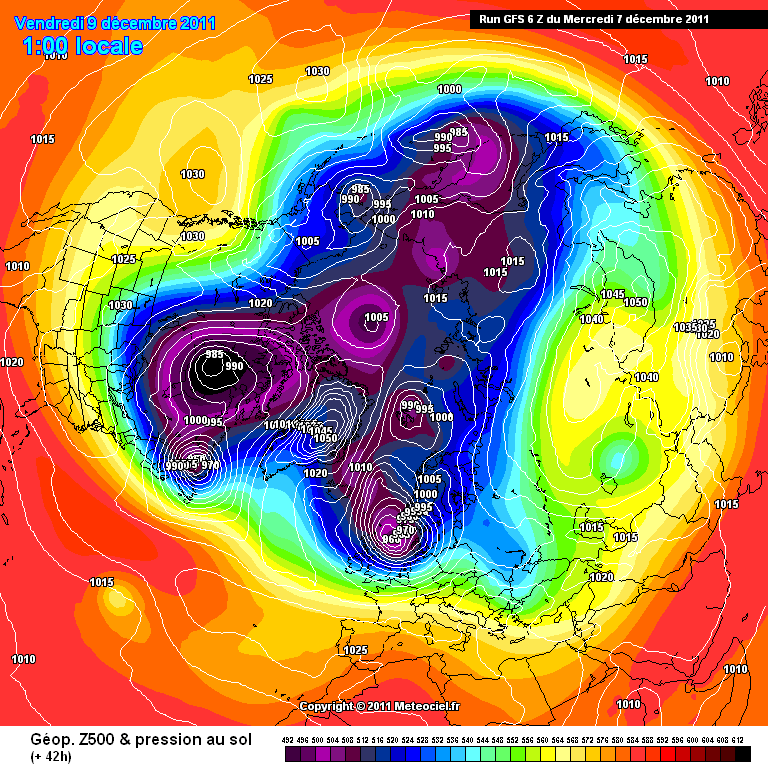
This image also shows you pressure systems, this time on a global scale. As you can see we have our projected one right over the North of the UK with winds heading straight from the an Arctic region
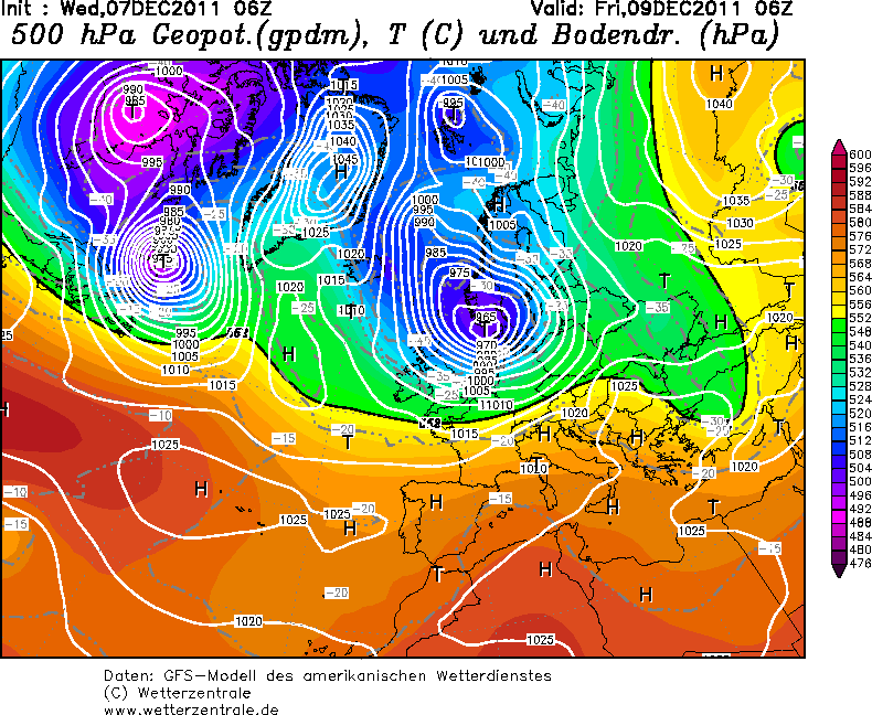
This image shows you the pressure and the temperature of the atmosphere at a height of around 18,000ft. So bearing in mind that the UK will be experiencing a very cold airflow of approximately -40oC at a height of 18,000ft.
ETA: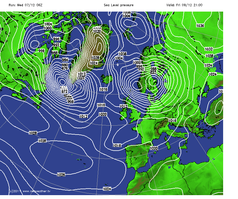
The above image is showing the LP system valid for Friday just East of NE Scotland, but whats worth noticing is the other LP system flowing out of Greenland. This other LP system is worse than the one we are about to experience so for those of you who think this will be all over by Saturday...it may well be only a lull in a series of major winter storms
Before i provide a synopsis of the event, i want you all to know that this is not a "normal" winter storm, this is a very deep storm, this storm will present a danger to life in more than 1 way.
A very strong jet stream running across the North Atlantic towards NW Europe over the next few days, driven by a steep thermal gradient, will rapidly deepen a low pressure system moving NE which will track close to northern Scotland on Thursday, by then a very deep depression with a low central pressure.
Although the exact track of this low is still not certain, strong model agreement today brings the centre of this deep depression northeast across the northernmost part of mainland Scotland during Thursday afternoon, with a risk of very strong and damaging winds possible across Scotland during the day -particularly western areas, the central belt and across to the northeast, where wind gusts may reach 80-90mph with isolated gusts of 100mph not out of the question. Further south, severe gales are also likely across Northern Ireland , northern and (parts of) eastern England - with gusts of 60-70mph likely with isolated gusts of up to 80 mph in exposed locations. Therefore the public are advised to expect travel disruption across northern Britain on Thursday, with a risk of damage to buildings and trees.
Also winds will veer northwesterly on Thursday afternoon, which will bring colder air with sleet and snow showers southeast across Scotland, Northern Ireland, NW England, Wales and later across The Midlands. Heavy snow is possible from these showers, which may bring significant accumulations across western areas with a risk of drifting in the strong winds, therefore there is also a risk of travel disruption from snow later on Thursday and through into Friday morning.
As the severe gale or storm force northwesterly winds transfer out into the North Sea Thursday night and Friday morning, there is also a risk of a storm surge heading down the North Sea which could bring a risk of coastal flooding as high winds and very low air pressure coincide with high tides
This storm will present danger to life through many factors. There will be a storm surge alone the East Coast of the UK, there will be winds possibly in excess of 100mph for northern Britain, there will be blizzards and a projected wind chill factor of below -15oC.
Since this is the festive season and there are a lot of Christmas Work Night Outs, if any of you are out and about...please wrap up warm. Don't be foolish with the short skirts and flimsy jackets.
This is a very dangerous storm and for those of you living north of Manchester, make sure you are prepared for power cuts and any structural damage.
As a side note. I am an avid weather fanatic and i don't scaremonger people about weather events. This is a real event that is serious in nature.
Be Safe...
Source
I do have synoptic charts and data graphs that i can post on this event if any of you wish to see them but using the image facility on ATS is dreadful. If anyone wants to see any of the images and model projections, let me know and i'll try to figure this out.
(There is no conspiracy here, this isn't HARRP or Chemtrails or Aliens or David Cameron, this is a notice for safety and advice that anyone wishes to share)
edit on 7/12/11 by jrmcleod because: (no reason given)
ETA: Here is a link to a map of the surface temperature and the wind speeds projected here
edit on 7/12/11 by jrmcleod because: (no reason given)
Here are a few images to help illustrate so more details. This is what your not being informed about at present, this is what the models are predicting. The Met and BBC will hold off as long as possible before upgrading their warnings, but this is some of the images they use.

The image above illustrates the isobar chart and the severity of wind in knots. the maximum projected wind speeds are about 75-80knots which i believe is about 90mph. The isobars are closely packed with a N-NW direction of wind. As you can see, the storm surge will most likely stretch down the entire East Coast.

This image also shows you pressure systems, this time on a global scale. As you can see we have our projected one right over the North of the UK with winds heading straight from the an Arctic region

This image shows you the pressure and the temperature of the atmosphere at a height of around 18,000ft. So bearing in mind that the UK will be experiencing a very cold airflow of approximately -40oC at a height of 18,000ft.
edit on 7/12/11 by jrmcleod because: (no reason
given)
edit on 7/12/11 by jrmcleod because: (no reason given)
ETA:

The above image is showing the LP system valid for Friday just East of NE Scotland, but whats worth noticing is the other LP system flowing out of Greenland. This other LP system is worse than the one we are about to experience so for those of you who think this will be all over by Saturday...it may well be only a lull in a series of major winter storms
edit on 7/12/11 by jrmcleod because: (no reason given)
edit on
7-12-2011 by alien because: (no reason given)
edit on Thu Dec 8 2011 by DontTreadOnMe because: EX TAGS
Incredible. Are there any other sources available, or are the meteorologists just now releasing this data?
My advice is to keep a check on any of your elderly neighbors. Many will be having to divide their small pensions on expensive heating and rising food
prices.
To be honest.....we get cold weather every single year...regardless of whether its accompanied by snow.
Im no more bothered about this years winter than the 31 ive witnessed before
Im no more bothered about this years winter than the 31 ive witnessed before
My bedroom is right at the top of my house and last night I was awoken about 4 times due to the most Heavy sleet/rain I have heard ....ever, I thought
my window was going to be smashed it was that heavy.
reply to post by boymonkey74
same here i didnt actually get to sleep at all last night with the strong winds and heavy hail/rain
still going on now actually
same here i didnt actually get to sleep at all last night with the strong winds and heavy hail/rain
still going on now actually
Wouldn't it be more fun if the heading read:
No but seroiusly thanks for the heads up.
ALS
Major UK Winter Snow fight 9th December 2012
No but seroiusly thanks for the heads up.
ALS
2012?
It's okay we've got another year...
Seriously though, cheers for the heads up. Time to buy some tea and scrumpets..
And make sure small one is suited and booted.
We've been looking forward to snow, but perhaps not THAT much..
It's okay we've got another year...
Seriously though, cheers for the heads up. Time to buy some tea and scrumpets..
And make sure small one is suited and booted.
We've been looking forward to snow, but perhaps not THAT much..
Well being down south, we do tend to miss out on most of the harshest weather in the UK. Most of my family are from Manchester and to be honest
whenever I visit it always feels a couple of degrees cooler and normally raining. But your a hardier bunch up north so you can handle it.
Originally posted by zanysami
Incredible. Are there any other sources available, or are the meteorologists just now releasing this data?
There are a few sources available for this but most of the Meteorologists wont publish too many details yet. The source i posted in the OP is a link to one of the best sources for UK weather. There is a forum there that is very active that can be browsed by guests.
reply to post by jrmcleod
The met office have a slightly different forecast. They are saying there will be 40 mph winds in the north and up to 60 in some parts of Scotland and the whole thing will start to calm down on Friday.They don't always get it right, I think the last time (this year) the met office warned about a storm for northern England it was really quite mild. Their weather warning is of ice and not wind anyway even thought it's obviously going to be gale force winds
www.metoffice.gov.uk...
Having said that it's good to be cautious and prepared.
Originally posted by woodwardjnr
Well being down south, we do tend to miss out on most of the harshest weather in the UK. Most of my family are from Manchester and to be honest whenever I visit it always feels a couple of degrees cooler and normally raining. But your a hardier bunch up north so you can handle it.
i wouldnt be so sure, i wither like an old woman whenever the temp drops below 10 degrees...which is most of the time
I live in Manchester , UK .
I first saw this storm mentioned on TV this morning and posted a warning on my F/book page .
Thank you so much for the detailed report . I just hope we are prepared when it comes .
I first saw this storm mentioned on TV this morning and posted a warning on my F/book page .
Thank you so much for the detailed report . I just hope we are prepared when it comes .
reply to post by DrHammondStoat
i actually find they are often wrong...
more often than not actually
i actually find they are often wrong...
more often than not actually
Originally posted by Deplume
2012?
It's okay we've got another year...
Seriously though, cheers for the heads up. Time to buy some tea and scrumpets..
And make sure small one is suited and booted.
We've been looking forward to snow, but perhaps not THAT much..
Ooooops! Changed. Thanks
Originally posted by DrHammondStoat
reply to post by jrmcleod
The met office have a slightly different forecast. They are saying there will be 40 mph winds in the north and up to 60 in some parts of Scotland and the whole thing will start to calm down on Friday.They don't always get it right, I think the last time (this year) the met office warned about a storm for northern England it was really quite mild. Their weather warning is of ice and not wind anyway even thought it's obviously going to be gale force winds
www.metoffice.gov.uk...
Having said that it's good to be cautious and prepared.
The Met are not releasing further details yet because of the uncertainty, however, ALL of the models are pointing to a severe low pressure for Friday. The Met will update their site with Alerts probably later today or tomorrow.
Watch and See...
Originally posted by woodwardjnr
My advice is to keep a check on any of your elderly neighbors. Many will be having to divide their small pensions on expensive heating and rising food prices.
This is very good advice.
Also, when the snows calmed and people start mooching about outside going to the shops etc. If you see elderly persons struggling on the icy pavements, spare a small amount of time if you have some and ask them if they would like to be escorted.
I had an unfortunate incident that landed me in A&E two winters ago when the snow was pretty bad. There were many elderly people in there with quite severe broken bones due to slipping on ice, some screaming in pain. because the local councils were so sparce with gritting pavements.
I actually witnessed a poor old guy fall over in the ice injuring himself quite badly. People laughed. Not just kids, but adults too. Only two people went to help him and call an ambulance, myself and another lady.
edit on 7-12-2011 by skitzspiricy because: (no reason given)
reply to post by moosevernel
Yes they seem to know vaguely what's going to happen I suppose it could be better or worse than they
say.
The met office's warning is actually for snow, not ice, I read the symbol wrong!
Yes they seem to know vaguely what's going to happen I suppose it could be better or worse than they
say.
The met office's warning is actually for snow, not ice, I read the symbol wrong!
Just realised I'm South of Manchester... Nottinghamshire to be precise... does that mean no snow?
new topics
-
Don't cry do Cryo instead
General Chit Chat: 2 hours ago -
Tariffs all around, Except for ...
Predictions & Prophecies: 4 hours ago -
Gen Flynn's Sister and her cohort blow the whistle on DHS/CBP involvement in child trafficking.
Whistle Blowers and Leaked Documents: 9 hours ago
top topics
-
Trump sues media outlets -- 10 Billion Dollar lawsuit
US Political Madness: 15 hours ago, 24 flags -
Bucks County commissioners vote to count illegal ballots in Pennsylvania recount
2024 Elections: 14 hours ago, 21 flags -
How long till it starts
US Political Madness: 17 hours ago, 17 flags -
Fired fema employee speaks.
US Political Madness: 16 hours ago, 10 flags -
Gen Flynn's Sister and her cohort blow the whistle on DHS/CBP involvement in child trafficking.
Whistle Blowers and Leaked Documents: 9 hours ago, 8 flags -
Don't cry do Cryo instead
General Chit Chat: 2 hours ago, 4 flags -
Anybody else using Pomodoro time management technique?
General Chit Chat: 12 hours ago, 3 flags -
Tariffs all around, Except for ...
Predictions & Prophecies: 4 hours ago, 3 flags
active topics
-
How can you defend yourself when the police will not tell you what you did?
Posse Comitatus • 83 • : Freeborn -
Tariffs all around, Except for ...
Predictions & Prophecies • 10 • : network dude -
Oligarchy It Is Then
Short Stories • 14 • : UKTruth -
Don't cry do Cryo instead
General Chit Chat • 1 • : angelchemuel -
Mike Tyson returns 11-15-24
World Sports • 54 • : angelchemuel -
President-Elect DONALD TRUMP's 2nd-Term Administration Takes Shape.
Political Ideology • 205 • : WeMustCare -
On Nov. 5th 2024 - AMERICANS Prevented the Complete Destruction of America from Within.
2024 Elections • 155 • : WeMustCare -
The Trump effect 6 days after 2024 election
2024 Elections • 143 • : cherokeetroy -
Bucks County commissioners vote to count illegal ballots in Pennsylvania recount
2024 Elections • 21 • : Irishhaf -
60s-70s Psychedelia
Music • 54 • : gort69
