It looks like you're using an Ad Blocker.
Please white-list or disable AboveTopSecret.com in your ad-blocking tool.
Thank you.
Some features of ATS will be disabled while you continue to use an ad-blocker.
1
share:
How about seeing a U-Turn projected in advance?

Source
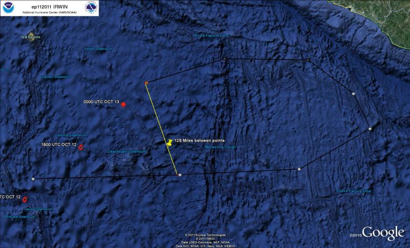
As the top left note indicates, this is a current image of projected track #28 for Tropical Depression Irwin, currently off the Mexican West Coast. There are several tracks that project this general path with slight variations, which seems to eliminate the possbility of one goofy data entry making for an errant feed out to the National Hurricane Center / NOAA website.
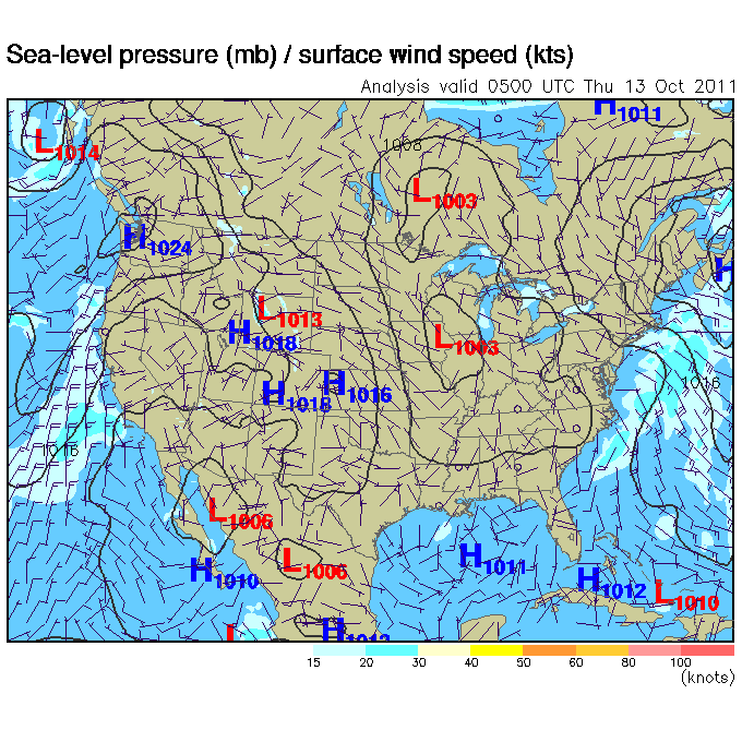
Additionally, I had checked a feed I have incorporated into one of my own sites to see wind patterns and speeds. It doesn't seem to help understand the behavior.

I am sure there is an explanation for this, and I'm likely seeing something that others who watch these storms with a personal interest in being impacted see by virtue of watching them far closer than I do. I found this odd enough to come share and perhaps get some suggestions as to what would cause it.
Note: Credit for having initially found this goes to LightAssassin, without whose Thread I would not have had reason to notice this, let alone look closely enough to see an oddity beneath the obvious glitch data RSOE made of this. He'd declined using the data for a serious thread about it and wished me the best
So there it is, now why is it? Ideas?

Source
As the top left note indicates, this is a current image of projected track #28 for Tropical Depression Irwin, currently off the Mexican West Coast. There are several tracks that project this general path with slight variations, which seems to eliminate the possbility of one goofy data entry making for an errant feed out to the National Hurricane Center / NOAA website.
Additionally, I had checked a feed I have incorporated into one of my own sites to see wind patterns and speeds. It doesn't seem to help understand the behavior.

I am sure there is an explanation for this, and I'm likely seeing something that others who watch these storms with a personal interest in being impacted see by virtue of watching them far closer than I do. I found this odd enough to come share and perhaps get some suggestions as to what would cause it.
Note: Credit for having initially found this goes to LightAssassin, without whose Thread I would not have had reason to notice this, let alone look closely enough to see an oddity beneath the obvious glitch data RSOE made of this. He'd declined using the data for a serious thread about it and wished me the best
So there it is, now why is it? Ideas?
This does happen with tropical storms, I've seen them do this in both the Atlantic and Pacific, it is a normal thing that they can do.
I follow the tropical weather season each and every year and spend a lot of time on weather forums, websites, etc, learning more about it and studying it.
I follow the tropical weather season each and every year and spend a lot of time on weather forums, websites, etc, learning more about it and studying it.
weird
could just be following warm currents?
hit a cold front and got forced the other way?
could just be following warm currents?
hit a cold front and got forced the other way?
I do not see a 180 degree U-turn, but I do see a deflection of about 90 degrees, which is normal for a Tropical front (moist warn air) approaching a
continental front (cold polar air).
reply to post by Deadscreameyes
Thank you. I had thought someone who watched these regularly would recognize it as normal, if it were. It looks odd and something I hadn't seen
before. It's nice hearing from others that it's nothing really notable. I'd debated which forum and how to approach it. By what you've said, this
was the right place and approach.
reply to post by mileysubet
I could have spent a bit more time notating this, and I'm making a note to myself on that for future threads I may make on similar graphics.
The upper track is inbound, the lower is outbound. The red points on their own are it's current and most recent positions.
To the left of where I noted the distance between inbound and outbound tracks, they seem to run almost parallel into and out of the 'round-a-bout' it's projected to do in the next few days as it comes up to the coast line.
Prior to my distance notation, you're right, the inbound actually does cross the projected outbound at quite an angle...nothing like parallel, but beyond that it turns into a direct path to the coast then flips straight back out. Interesting, if nothing else.
Originally posted by Wrabbit2000
reply to post by mileysubet
I could have spent a bit more time notating this, and I'm making a note to myself on that for future threads I may make on similar graphics. The upper track is inbound, the lower is outbound. The red points on their own are it's current and most recent positions.
To the left of where I noted the distance between inbound and outbound tracks, they seem to run almost parallel into and out of the 'round-a-bout' it's projected to do in the next few days as it comes up to the coast line.
Prior to my distance notation, you're right, the inbound actually does cross the projected outbound at quite an angle...nothing like parallel, but beyond that it turns into a direct path to the coast then flips straight back out. Interesting, if nothing else.
The weather will be interesting where these two fronts meet, glad I am not in the area.
Areas of high pressure can affect a tropical system. If a strong area of high pressure exists, it can deflect the storm away from the storm. If it
weakens, it can move in the path of least resistance. Other factors to steer a storm: weak upper level winds, frontal boundaries (cold fronts,
usually), and many other combining factors contribute.
I found this interesting site listing a few weird moving storms and their tracks:
www.easternuswx.com/bb/index.php?/topic/169965-weirdest-hurricane-track-ive-seen/
I found this interesting site listing a few weird moving storms and their tracks:
www.easternuswx.com/bb/index.php?/topic/169965-weirdest-hurricane-track-ive-seen/
edit on 13-10-2011 by ghr54321 because: (no reason given)
reply to post by Wrabbit2000
In Australia, up until the time of political correctness, all cyclones were given female names. The reason was that they were (and indeed still are) very unpredictable. They can go arrow straight, then stop and seem to sulk for a bit, the do a 180 or a 90 or just keep on going as they were.
Please don't pay out on me for the female name thing..It's actually true.
You know whats funny is I was watching a show on onDemand called Curiosity, and they were talking about how the world was suppose to end, and they
said something about an Ark Storm on the West Coast. It's happened before in history why not again....I am ready for it
reply to post by Petrov62
That is a really fascinating piece of trivia. I was reading that as tongue in cheek humor until I reached the end where you state it is true. Now that is certainly an example of learning something new every day. Thanks for the colorful piece of background!
That is a really fascinating piece of trivia. I was reading that as tongue in cheek humor until I reached the end where you state it is true. Now that is certainly an example of learning something new every day. Thanks for the colorful piece of background!
reply to post by Wrabbit2000
Yes of course this happens all the time. Some time in the mid 90 I watched Hurrican Danny approach the east coast of NC and VA. It stayed off shore moved to the north east then moved to the south west and took another shot at us. This second time it crossed over the coast line and then I think headed north north east out to sea again. I was amazed because I'd never seen a hurricane do that. It made a complete circle.
Yes of course this happens all the time. Some time in the mid 90 I watched Hurrican Danny approach the east coast of NC and VA. It stayed off shore moved to the north east then moved to the south west and took another shot at us. This second time it crossed over the coast line and then I think headed north north east out to sea again. I was amazed because I'd never seen a hurricane do that. It made a complete circle.
reply to post by karen61057
Well, I guess I can only ask myself, who needs HAARP to blame when apparently we can watch nature with her own sense of humor. I appreciate the
replies and explanation as to how this may not be an every day occurrence, but isn't unheard of either. I swear, every time I think I've seen just
about everything, Mother Nature proves me wrong and sends me back to the drawing board. It's great learning though!
edit on 14-10-2011 by Wrabbit2000 because: (no reason given)
Olaf made a complete stop and turned around.
Guillermo did a large U Turn.
These are just 2 I quickly found, both from 1997. Most Pacific hurricanes and tropical storms move east to north west and circle back around east as they move further north.
Very how interesting, Irwin is circling the wrong way.
Guillermo did a large U Turn.
edit on 10/17/11 by
Cyprex because: (no reason given)
These are just 2 I quickly found, both from 1997. Most Pacific hurricanes and tropical storms move east to north west and circle back around east as they move further north.
Very how interesting, Irwin is circling the wrong way.
edit on 10/17/11 by Cyprex because: (no reason given)
new topics
-
Of course it was DEI
Dissecting Disinformation: 29 minutes ago -
2nd Day Thanksgiving!...(leftovers!!)
General Chit Chat: 2 hours ago
top topics
-
New Disney Star Wars Films Failing Test of Time?
Movies: 14 hours ago, 5 flags -
2nd Day Thanksgiving!...(leftovers!!)
General Chit Chat: 2 hours ago, 3 flags -
Of course it was DEI
Dissecting Disinformation: 29 minutes ago, 3 flags
active topics
-
Of course it was DEI
Dissecting Disinformation • 1 • : rickymouse -
New Disney Star Wars Films Failing Test of Time?
Movies • 18 • : Popoll -
2nd Day Thanksgiving!...(leftovers!!)
General Chit Chat • 4 • : nugget1 -
Unidentified Flying Objects Over U.S. Military Bases in Northeast UK, as of roughly 11 a.m. CST.
Aliens and UFOs • 32 • : Kangawoo2 -
The Party of Peace - Trump Cabinet Picks Targeted with Death Threats
US Political Madness • 51 • : RazorV66 -
-@TH3WH17ERABB17- -Q- ---TIME TO SHOW THE WORLD--- -Part- --44--
Dissecting Disinformation • 3416 • : duncanagain -
Results of the use of the Oreshnik missile system in Dnepropetrovsk
World War Three • 263 • : DontTreadOnMe -
Anyone like the Scorpions?
Music • 23 • : Flyingclaydisk -
The Cost of True Discipleship—Count the Cost
Religion, Faith, And Theology • 5 • : alwaysbeenhere2 -
Mass UAP events. DC. Machester Airport, UFOs over sub base in CT, Nuke bases.
Aliens and UFOs • 24 • : devilhunter69
1
