It looks like you're using an Ad Blocker.
Please white-list or disable AboveTopSecret.com in your ad-blocking tool.
Thank you.
Some features of ATS will be disabled while you continue to use an ad-blocker.

Help Me Identify This Structure Just South of Denver International
page: 1share:
I fly through DEN quite often. I like the airport personally, and read the conspiracy stuff about it mostly out of curiosity. Other than the strange
paintings, I've never personally seen anything unusual while there. I often brag about the place when I'm flying with friends in other airports,
"This place has nothing on the Denver Airport!"
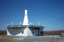
On a recent arrival, my plane approached from the south and we went over a structure which struck me as odd. Apparently, I'm not the only person to have noticed it, as when I finally found it on Google Maps, and hit "What's near here" an arrow came up marking its coordinates, but without any description of what it was.
So, I am in no way claiming that this structure is anything unusual, I just have no idea what it is. I'm sure many of you know more about construction than I do, so I'm asking anyone who wants to help to tell me what this is.
Here is the link to Google Maps: 39.816645, -104.658844
Here are the more traditional coordinates: +39° 48' 59.92", -104° 39' 31.84"
Much of Colorado is actually a high plains desert, and therefore rather dry. So, instead of pretty green stuff around it (as on Google Maps), I just saw a bunch of dirt with some walls in the middle of it. I'm not actually certain it was this same structure, but it was at least very similar and this is the only one I see in the area of DEN.
I could guess but I'm sure you don't want to hear that. Would be very interested to find out. Thanks for posting.
i couldnt tell you what it is, but it looks abandoned and overgrown to me
IF you follow the depression up the map you can clearly see lines where vegetation has overgrown
its easier to see on a picture so here :
[atsimg]http://files.abovetopsecret.com/images/member/64f2e205cf8f.png[/atsimg]
so i would say whatever it was it is not in use anymore
IF you follow the depression up the map you can clearly see lines where vegetation has overgrown
its easier to see on a picture so here :
[atsimg]http://files.abovetopsecret.com/images/member/64f2e205cf8f.png[/atsimg]
so i would say whatever it was it is not in use anymore
It looks to me like an old military explosives testing ground. Notice the small building across the road, it looks like a close range explosives
visual observation building. By explosives Im not referring to nuclear explosives by any means, the facility seems too small for that. It could also
be an abandoned munitions storage building with a firming range across the road. In this case the small building across the road would have served as
an observation outpost as well. Probably like I said, an old military explosives or munitions testing facility.
Unfortunately this is as far as Street Level will take us.

They seem to be building a pipe network in that area. But I agree with the above re. the build appearing to be old and overgrown.
They seem to be building a pipe network in that area. But I agree with the above re. the build appearing to be old and overgrown.
Thanks for the quick replies! I agree with you guys it looks overgrown. As I mentioned, currently, most of the vegetation in that area is dead, so
from my perspective in the plane, it looked like it was popping up out of the relatively flat dirt around it. Even still, it looked abandoned; you
could see where dust and dirt was pooling up against the walls.
Colorado is always rather dry, but this summer has been pretty bad. This has been exacerbated by construction projects in the area. I was driving a visitor into town from the airport back in April, and we could hardly see due to the dust blowing through. Then the largest tumbleweed I've seen (about a yard in diameter) hit the side of my car as we went down the highway. To me, it was sort of funny. To him, a person brand new to Colorado and considering moving here for a position, it may not have been endearing.
Also, I too noticed a lot of those large concrete pipe pieces in the airport area.
edit on 18-7-2011 by FrostyPhilosopher because:
Acknowledgement of a recent post.
I live in Denver, if you don't get your answer in the next few days I will take a drive out there and check it out on my days off work. Shoot me an
email [email protected] if you still need me to do it. I would say Wednesday would work for me.
reply to post by moosevernel
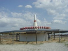
Thanks, moosevernel for that highlighted picture. It does indeed look like there was more of a path there at one time. In fact, it seemed even easier to see from the plane. While there was little vegetation, there were definitely paths worn into the dirt. After looking at a couple other threads on unidentified structures, I found many people thought Bing's map service provided better pictures than Google's. I had not yet used Bing, being sort of a Google fanboy, but I was able to find some nice images using Bing. I especially like their feature where you can get satelite images from multiple angles.
First, a picture that matches up with the one I already posted, just drier looking. So, this is a little closer to what I saw from the plane, though I want to say that it was even drier/dirtier when I flew in (more like the field on the west side of the road, left side of the picture), literally just dirt with no visible vegetation.
[atsimg]http://files.abovetopsecret.com/images/member/b712329a4c9e.png[/atsimg]
Next, and this is the cool part, the Bing map looking southward, flipping the direction. It seems to give us a better look at the walls of the structure.
[atsimg]http://files.abovetopsecret.com/images/member/52f513aad632.png[/atsimg]
reply to post by taccj9903
Hey Channelingmyself (taccj9903), that's a great offer! I don't live in Denver, and even if I did, I'm really busy with work right now, so probably couldn't do anything soon anyway! I'll let you know, but I'm sure many of us would find an in-person investigation interesting.
edit on 18-7-2011 by FrostyPhilosopher because: Adding a reply-to tag
edit on 18-7-2011 by FrostyPhilosopher because:
Grammar
reply to post by FrostyPhilosopher
No problem, keep me posted via email if you would like an on ground investigation. I might not get back to ATS to check any requests.
No problem, keep me posted via email if you would like an on ground investigation. I might not get back to ATS to check any requests.
I am not quite sure exactly what this is either.
Perhaps it was part of a drainage network 50 years ago during wetter times?
It does lack aspects I would expect from a drainage ditch so I do have doubts about that explanation.
The shapes seem to resemble bunker wall layout. It's rather odd.
Perhaps it was part of a drainage network 50 years ago during wetter times?
It does lack aspects I would expect from a drainage ditch so I do have doubts about that explanation.
The shapes seem to resemble bunker wall layout. It's rather odd.
It's the entrance to an UGB, that TPTB have built for you guys when the SHTF. The arrows will show you the way.
Probably not, but maybe!
Probably not, but maybe!
Can't look at google directly atm. I can tell you though that depending on where it is and how close it is to the airport, that they did build an
entire building and I believe a runway was started too, then they realized it was off and buried the whole thing and started over. At least that was
the official story. It seemed ludicrous to people paying attention though. It was just so much money to waste and it could have been worked around.
Besides who makes that big a mistake while building an airport? Us conspiracists for the most part, think it was just a cover story for building
certain underground parts. They still use parts of it to store equipment. So they claim.
I dunno. What you've found could be related to that. Or maybe not. Not sure where it is exactly in relation to the airport.
Also, if you pay attention when driving in to the airport, you can see things in the middle of empty fields dotted around the massive empty land that is part of the airport, things that look like vent tubes. For air circulation at the DUMB maybe.
Weird place DIA..
It looks like it could be a culvert, although one that has been neglected for years.
The vegetation growing in a dry location could suggest water used to flow there. The culvert would have allowed the water to flow and give a safe location for people/wildlife to cross the water.
The vegetation growing in a dry location could suggest water used to flow there. The culvert would have allowed the water to flow and give a safe location for people/wildlife to cross the water.
Looking at a historical timeline, it looks to me that this is a runoff swale.
This is especially apparent when you turn on the 3-D view and tilt down low -almost horizontal, and then pan around the feature.
Also, depending on your Google Earth version and attribute sources, you should click the "Historical Imagery" link under the "views" tab. This will take you through all of the available imagery back through time (limited by available data, of course). It shows the structure back through at least the early '90s.
My vote is a swale, intended to channel storm runoff to a designated area to minimize pooling and flooding. The concrete structures act as baffles during especially strong downpours. There may even be cisterns or gravel sump pits just below the baffles to ease drainage.
Having obtained my own pilot's license in Greeley, CO (Weld County Airport), I can vouch that this structure has been in place for a couple of decades at least.
I don't think it's anything ominous or mysterious at all. In fact, a quick call or visit to the urban planning/engineering counter at the county would probably confirm this for you rather quickly. Show it to them!
If I was flying in and out of DEN on a regular basis, I would take great comfort in knowing that several of these were around the airport to help drain away excess water. Look around some more - you might find a few others (though they may not be constructed the same or appear the same way).
Happy trails...
It appears the majority consensus here is that it is related to drainage (culvert, swale, etc). I agree, that seems the most likely explanation.
Though, I did find the one post about the possibility of it being some old underground storage, perhaps for explosives, interesting as well. As I
mentioned above, I saw this from a plane on approach to DEN, thought it looked interesting, and did some internet investigating to find pictures of
it. I wasn't sure what it was, and figured some others around here are also the curious sort, so thought I would share.
Thank you everyone for posting. Case closed.
Thank you everyone for posting. Case closed.
Nice threat, looks like an old passage-way or possible draining system
by the way... there's something really going on at the north end of the airport!!
Check Google Earth newest pictures
Near the 6 massive fuel tanks there's something being constructed that looks like a HAARP system!!!
(OMG would it be thé structure to send the messege to the Mothership? )
by the way... there's something really going on at the north end of the airport!!
Check Google Earth newest pictures
Near the 6 massive fuel tanks there's something being constructed that looks like a HAARP system!!!
(OMG would it be thé structure to send the messege to the Mothership? )
O.K. chimming in to give this thread some credibility and facts about what this structure is. Unfortunately it is not the entrance to an elaborate
underground base, nor is it a drainage system. What you are viewing is called a VORTAC facility also known as a (Very High Frequency Omni Directional
Tactical Air Navigational Aid) with DME (Distance Measuring Equipment) . Basically it is used in aviation as a navigational aid developed by the
Military. VOR stations transmit very high frequency signals from 108-117.95 MHz in 360 radials in all directions in one degree increments numbered
clockwise from magnetic north.
In this diagram of the airport (Disregard the Red lines and dot) you'll see the hexagon inside of a square which is the airport symbol used to identify a VOR station in location to the airport used in aeronautical sectional charts in the exact location on the south end of Runway 35L (Left). If you do a side-by-side comparison to Google Maps you'll see it is in the EXACT location.
CASE CLOSED.
edit on 5-9-2011 by Yamaha Dave because: (no reason given)
edit on 5-9-2011 by Yamaha Dave because: (no reason given)
reply to post by Yamaha Dave
Wrong. As a licensed pilot having utilized many VORTAC facilities from hundreds of airports over many years, I can very confidently tell you that this feature from the OP is NOT a VORTAC. Not even close:
All VORTACS are above ground facilities by necessity since, by definition, they must broadcast OMNIDIRECTIONAL signals so that pilot navigation systems can vector to/from the facility.
You're right about one thing, though: CASE CLOSED - it's a runoff swale - meant to keep rain water from pooling up on the runways and tarmac.
P.S. Um - you're illustration does NOT line up with the maps. How about showing us an overlay of the two? Tip: try a real aeronautical chart from the FAA - they have the precise location of all navigation beacons (VORs) at DEN.
It's an irrigation system being set up for the fields probably going to connect a canal to it somehow.
edit on 7/9/2011 by JROCK2527 because:
(no reason given)
What are all these tunnels there? The sewers? Im sure this entrance was also made for water, but the sewers are too big. Even an aircraft from the
type of a saucer can go out of these sewers. So unless the sewers are something more.. this on the picture looks like made for the same purpose
new topics
-
Of all things, grunge music. Short, simple, relevant, not NSFW.
Conspiracies in Religions: 3 hours ago -
A new phase of evil brewing
General Conspiracies: 4 hours ago -
Influx Of Migrants Just Doubled The Population Of A Small Ohio Town
Social Issues and Civil Unrest: 5 hours ago -
We Now Know the Size of the Modern Gaming Audience - Sweet Baby Cries
Video Games: 10 hours ago -
Nearly one-third of Border Patrol’s cameras along the US-Mexico border ‘don’t work’
Social Issues and Civil Unrest: 11 hours ago
top topics
-
Soros minions think Trump will win
2024 Elections: 12 hours ago, 25 flags -
Nearly one-third of Border Patrol’s cameras along the US-Mexico border ‘don’t work’
Social Issues and Civil Unrest: 11 hours ago, 10 flags -
The UN’s DARK Agenda: Agenda 2030
New World Order: 14 hours ago, 8 flags -
A new phase of evil brewing
General Conspiracies: 4 hours ago, 7 flags -
Influx Of Migrants Just Doubled The Population Of A Small Ohio Town
Social Issues and Civil Unrest: 5 hours ago, 6 flags -
What's the Cheney Game?
Politicians & People: 13 hours ago, 5 flags -
We Now Know the Size of the Modern Gaming Audience - Sweet Baby Cries
Video Games: 10 hours ago, 4 flags -
Of all things, grunge music. Short, simple, relevant, not NSFW.
Conspiracies in Religions: 3 hours ago, 3 flags
active topics
-
The Fight for Election Integrity Continues -- Audits, Criminal Investigations, Legislative Reform
2024 Elections • 4299 • : IndieA -
A new phase of evil brewing
General Conspiracies • 7 • : rickymouse -
BREAKING Israeli military says possibility' it has killed Hamas leader Yahya Sinwar
War On Terrorism • 60 • : KrustyKrab -
Major 2024 Endorsements for Donald J. Trump to be U.S. President Again.
2024 Elections • 15 • : WeMustCare -
Of all things, grunge music. Short, simple, relevant, not NSFW.
Conspiracies in Religions • 12 • : FullHeathen -
Tens of thousands of illegal immigrants with violent criminal convictions roaming US streets:ICE
2024 Elections • 63 • : WeMustCare -
Exhausted Donald has a Mic Malfunction
2024 Elections • 57 • : confuzedcitizen -
DoD Directive 5240.01 has been Renewed - Includes Lethal Force against Civilians?
Posse Comitatus • 72 • : confuzedcitizen -
Is Harris paying influencers, celebrities 20 grand to attend the DNC convention through PR agents?
2024 Elections • 39 • : WeMustCare -
Biden's Commerce Secretary says "Trump should Be 'extinguished for good"
US Political Madness • 32 • : WeMustCare