It looks like you're using an Ad Blocker.
Please white-list or disable AboveTopSecret.com in your ad-blocking tool.
Thank you.
Some features of ATS will be disabled while you continue to use an ad-blocker.
share:
Originally posted by JustMike
Another one for Japan. Not far from Yokohama and Tokyo this time:
Magnitude 5.3 - NEAR THE EAST COAST OF HONSHU, JAPAN
2011 December 02 20:55:27 UTC
Versión en Español
* Details
* Summary
* Maps
* Scientific & Technical
Earthquake Details
* This event has been reviewed by a seismologist.
Magnitude 5.3
Date-Time
* Friday, December 02, 2011 at 20:55:27 UTC
* Saturday, December 03, 2011 at 05:55:27 AM at epicenter
* Time of Earthquake in other Time Zones
Location 35.267°N, 140.179°E
Depth 17.5 km (10.9 miles)
Region NEAR THE EAST COAST OF HONSHU, JAPAN
Distances 53 km (32 miles) ESE of Yokohama, Honshu, Japan
60 km (37 miles) SE of TOKYO, Japan
121 km (75 miles) E of Numazu, Honshu, Japan
124 km (77 miles) SSW of Mito, Honshu, Japan
Location Uncertainty horizontal +/- 13.5 km (8.4 miles); depth +/- 5.9 km (3.7 miles)
Parameters NST=293, Nph=295, Dmin=228.2 km, Rmss=0.77 sec, Gp= 43°,
M-type=body wave magnitude (Mb), Version=8
Source
* Magnitude: USGS NEIC (WDCS-D)
Location: USGS NEIC (WDCS-D)
Event ID usc000716d
Source: USGS
Quite a shallow quake, as well.
Mike
Given it's location and shallow nature I'm wondering if this is a foreshock.
Many scientists and other interested parties have anticipated another large quake - possible even larger than the march megaquake and tsnumani. It would certainly be devestating, then you have news of Katla supervolcanoe possibly waking up.
Virginia tossing around again:
3.1
Date-Time Saturday, December 03, 2011 at 11:12:50 UTC
Saturday, December 03, 2011 at 06:12:50 AM at epicenter
Time of Earthquake in other Time Zones
Location 37.013°N, 81.739°W
Depth 5 km (3.1 miles)
Region VIRGINIA
Distances 6 km (4 miles) SSE (164°) from Claypool Hill, VA
9 km (5 miles) SSE (165°) from Cedar Bluff, VA
11 km (7 miles) SSE (147°) from Richlands, VA
166 km (103 miles) NW (308°) from Winston-Salem, NC
411 km (255 miles) SSW (202°) from Pittsburgh, PA
Location Uncertainty horizontal +/- 13.5 km (8.4 miles); depth +/- 3.1 km (1.9 miles)
Parameters NST= 23, Nph= 30, Dmin=119.1 km, Rmss=1.18 sec, Gp=101°,
M-type="Nuttli" surface wave magnitude (mbLg), Version=7
Source Magnitude: USGS NEIC (WDCS-D)
Location: USGS NEIC (WDCS-D)
Event ID usc00071hx
link: earthquake.usgs.gov...
This Virginia quake is much farther SW than the 23 August shaker and aftershocks. I'm in VA, but didn't feel a thing--too far away in the NW corner
of the Commonwealth.
And Muzzy, I hope you get your water line repaired soon, and no more earthquakes so close to your home ...take care.
And Muzzy, I hope you get your water line repaired soon, and no more earthquakes so close to your home ...take care.
reply to post by Disconnected Sociopath
Well as you probably are aware I don't hold with the scaremongering that there will be another mega-quake in Honshu, but I don't discount a very small possibility of the long awaited Tokai mega-quake in the near future (say 2 years).
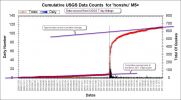
Currently if one looks at the trend of quakes labelled as Honshu it is following the normal patterns and indeed another 3 months at the current rates may see this area back to normal.
This is the mag 5+ cumulative counts graph.
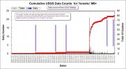
Looking at just the mag 6+ quakes a similar picture emerges.
In short, no I don't believe this is a foreshock to any sizeable earthquake in that area.
Well as you probably are aware I don't hold with the scaremongering that there will be another mega-quake in Honshu, but I don't discount a very small possibility of the long awaited Tokai mega-quake in the near future (say 2 years).
Currently if one looks at the trend of quakes labelled as Honshu it is following the normal patterns and indeed another 3 months at the current rates may see this area back to normal.
This is the mag 5+ cumulative counts graph.

Looking at just the mag 6+ quakes a similar picture emerges.

In short, no I don't believe this is a foreshock to any sizeable earthquake in that area.
then you have news of Katla supervolcanoe possibly waking up.
Please let us get facts straight. Katla has NEVER produced a supervolcano eruption as far as I am aware.
A supervolcano, although NOT an official term is generally classified as a volcano that has produced a VEI 8 eruption, unless you are on RSOE and then you get more bang for your bucks with VEI 7 being a supervolcano.
Yes Katla is a bit of a mean volcano, but VEI 5 is the best she has managed. Bear in mind that VEI is like magnitude, it is logarithmic. VEI 4 = 0.1 cu km, VEI 8 = 1000+ cu km. As a comparison Mt St Helens just made it into VEI 5.
1999 Jul 17 VEI:0
1955 Jun 25 VEI:0
1918 Oct 12 VEI:4+
1860 May 8 VEI:4
1823 Jun 26 VEI:3?
1755 Oct 17 VEI:5?
1721 May 11 VEI:5?
1660 Nov 3 VEI:4
1625 Sep 2 VEI:5
1612 Oct 12 VEI:4
1580 Aug 11 VEI:4
1550 ??? ?? VEI:4
1500 ??? ?? VEI:4
Extracted from Katla: Eruption history (Smithsonian)
Go to the link for the rest of them and the lengths of time for each eruption. Some can be quite long - as much as 4 months on one occasion.
It is a fact that it will erupt some time soon. It is also a fact that worrying about it is pointless as we can do nothing to stop it. Iceland has to prepare for it, and we just sit and watch the ash fall as I am sure we will get some where I live.
It will be a majestic and awe inspiring natural event I have no doubt, but other than that it is normal. (SNAFU)
Forgot to add the link to the VEI scale
VEI Ejecta volume
0 < 10,000 m³
1 > 10,000 m³
2 > 1,000,000 m³
3 > 10,000,000 m³
4 > 0.1 km³
5 > 1 km³
6 > 10 km³
7 > 100 km³
8 > 1,000 km
edit on 3/12/2011 by PuterMan because: To add image link because I forgot because I am getting old and the memory is going, trouble is it is
not taking me with it and I object to it trolling off on it's own without a by your leave and then expecting me to be pleased when it eventually
deigns to return. Humph!
update on Cook Strait 5.7
All quiet here again, been a 2nd small aftershock overnight
MAG, REF, LAT, LONG, UTC, DEPTH
2.598, 3620992, -41.31139, 174.30701, 2011/12/3 9:20:35, 64
Made a mess of LISS SNZO, screenshot I took last night
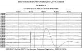
quite a localised event, only just shows on the LISS Antarctica and S Pacific Islands graphs, CTAO which at 3547 km away is the next closest station that does a LISS graph has a a bit of a trace
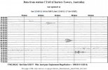 (6:35ish)
Has to be the most violent local event since 2006 in my recollection
MAG, REF, LAT, LONG, UTC, DEPTH, DISTANCE FROM HOME
6.374, 2376455, -40.17884,173.67229,2005/3/13 15:8:13, 143, 137.3 km NW
5.989, 2526413, -40.21284, 173.42439, 2006/2/15 12:15:56, 173, 152.7 km NW
5.657, 3620927, -41.36345,174.31468,2011/12/3 6:19:10, 56, 75.22 km SW
have had a few 4.8's and 5.0's since 2006 but no where near the intensity of a 5.5+
No water yet, Plumber should be here in an hour, luckily had half a pot of coffee on the perculator last night so we are good for now. Have 60 litres of fresh water emergency supply stashed that we could crack open if we had to.
Amazing how you take water on tap for granted, I have been to the tap a few times since, to wash a cup or brush my teeth and forgot there was nothing in the pipes. Really bringing home the reality of what they went through in Christchurch the last 14 months .................. and all we have lost is the water for 12 hours
I wonder if these Chatham Rise and South Canterbury Bight events a few days prior were a warning?, I was expecting something more at Christchuch after those
All quiet here again, been a 2nd small aftershock overnight
MAG, REF, LAT, LONG, UTC, DEPTH
2.598, 3620992, -41.31139, 174.30701, 2011/12/3 9:20:35, 64
Made a mess of LISS SNZO, screenshot I took last night

quite a localised event, only just shows on the LISS Antarctica and S Pacific Islands graphs, CTAO which at 3547 km away is the next closest station that does a LISS graph has a a bit of a trace
 (6:35ish)
 Has to be the most violent local event since 2006 in my recollection
MAG, REF, LAT, LONG, UTC, DEPTH, DISTANCE FROM HOME
6.374, 2376455, -40.17884,173.67229,2005/3/13 15:8:13, 143, 137.3 km NW
5.989, 2526413, -40.21284, 173.42439, 2006/2/15 12:15:56, 173, 152.7 km NW
5.657, 3620927, -41.36345,174.31468,2011/12/3 6:19:10, 56, 75.22 km SW
have had a few 4.8's and 5.0's since 2006 but no where near the intensity of a 5.5+
No water yet, Plumber should be here in an hour, luckily had half a pot of coffee on the perculator last night so we are good for now. Have 60 litres of fresh water emergency supply stashed that we could crack open if we had to.
edit on 3-12-2011 by muzzy because: to activate LISS text to
a link
Amazing how you take water on tap for granted, I have been to the tap a few times since, to wash a cup or brush my teeth and forgot there was nothing in the pipes. Really bringing home the reality of what they went through in Christchurch the last 14 months .................. and all we have lost is the water for 12 hours
edit on 3-12-2011 by muzzy because: (no reason given)
I wonder if these Chatham Rise and South Canterbury Bight events a few days prior were a warning?, I was expecting something more at Christchuch after those
edit on 3-12-2011 by muzzy because: (no reason
given)
source(thecomingcrisis.blogspot.com...
TextNew Zealand 5.7 Magnitude Earthquake shatters windows, forces evacuations - 3rd Dec 2011 Highrise windows shattered, apartments were evacuated and houses shook as a 5.7 magnitude earthquake rocked Wellington, Marlborough and much of central New Zealand.
I don't think this is good!
Originally posted by diamondsmith
I don't think this is good!
I don't think any earthquakes are "good" but this doesn't seem very bad.
Police say there has been damage to louvres and windows broken on the Meridian Building on Custom Quay Street in central Wellington. Some of the louvres have come loose and are hanging precariously.
The Quay Apartments in Picton had to be evacuated as a hot water cylinder burst and set off the fire alarms. Two other cylinders were also damaged in the town, according to the Fire Service.
Supermarkets in Wellington say they felt the quake but it was not strong enough for things to fall off shelves.
thecomingcrisis.blogspot.com...
reply to post by diamondsmith
well the energy released was equal to 4612.202 tonnes of TNT going off, some damage had to be expected.
reply to post by Phage
you are right, on the overall scale of things not a big deal.
What it will do is make the City Council push ahead urgently with instructions to building owners to upgrade their buildings to the 2011 Code or shut down. After the Christchuch quakes they did a detailed inspection of all Government buildings here in Wellington as to the earthquake risk and 50% have to be upgraded. Several school buildings have been shut down.
BTW its Customhouse Quay and the Meridian Building is built on the wharf (relaimed land) its a newish building proclaimed as one of NZ's greenest building.Theres a picture of it here
I wouldn't call it a high rise, its only 2-3 stories.
I bet Customhouse Quay is swarming with high-vis vested and hard hatted officials this morning
ETA: Geez that linked site is slooooooooooooooooow to load, they need to tidy it up a bit. I see the story was originally on TVNZ, so its their reporter who got the street wrong
well the energy released was equal to 4612.202 tonnes of TNT going off, some damage had to be expected.
reply to post by Phage
you are right, on the overall scale of things not a big deal.
What it will do is make the City Council push ahead urgently with instructions to building owners to upgrade their buildings to the 2011 Code or shut down. After the Christchuch quakes they did a detailed inspection of all Government buildings here in Wellington as to the earthquake risk and 50% have to be upgraded. Several school buildings have been shut down.
BTW its Customhouse Quay and the Meridian Building is built on the wharf (relaimed land) its a newish building proclaimed as one of NZ's greenest building.Theres a picture of it here
I wouldn't call it a high rise, its only 2-3 stories.
I bet Customhouse Quay is swarming with high-vis vested and hard hatted officials this morning
edit on 3-12-2011 by muzzy because: add
link
ETA: Geez that linked site is slooooooooooooooooow to load, they need to tidy it up a bit. I see the story was originally on TVNZ, so its their reporter who got the street wrong
edit on 3-12-2011 by muzzy because: (no reason given)
earthquake.usgs.gov...
The 3.1M Virginia earthquake was caused by fracking. Distance from epicenter to the nearest fracking well is 120 meters. Just a little longer than a Canadian football field. That's 0.12 kilometers. 407 feet. 0.08 miles. Number of fracking wells in a 1 kilometer radius? I don't know. I'm not counting them all. There's enough. Lots.
Fearmongering.
I've got lots for sale.
Edit to add stuff.
www.upi.com...
www.rdmag.com...
www.sciencecentric.com...
www.scienceagogo.com...
www.bbc.co.uk...
www.cbc.ca...
www.wnyc.org...
www.marcellus-shale.us...
www.dmme.virginia.gov...
edit on 3-12-2011 by ericblair4891 because: (no reason given)
Originally posted by muzzy
update on Cook Strait 5.7
Amazing how you take water on tap for granted, I have been to the tap a few times since, to wash a cup or brush my teeth and forgot there was nothing in the pipes. Really bringing home the reality of what they went through in Christchurch the last 14 months .................. and all we have lost is the water for 12 hours
pipe is fixed had 2 splits in it
crisis over
I really don't know how the people of ChCh coped, I was starting to feel "ratty" not having showered this morning
I guess we were distracted by all the aftershocks so water was only one of the issues. It's a reminder that it is always good to have surplus water
stored. Even a sponge bath can feel delicious; right Nurse?
Originally posted by diamondsmith
Very shallow,
source(earthquake.usgs.gov...
TextMagnitude 5.6 Date-Time Saturday, December 03, 2011 at 09:27:11 UTC Saturday, December 03, 2011 at 05:27:11 AM at epicenter Location 17.940°N, 59.829°W Depth 10.3 km (6.4 miles) Region EAST OF BARBUDA, LEEWARD ISLANDS Distances 212 km (132 miles) E (83°) from Codrington, Barbuda 213 km (133 miles) E (81°) from Codrington, Barbuda, Antigua & Barbuda 220 km (137 miles) ENE (64°) from Willikies, Saint Philip, Antigua & Barbuda 231 km (143 miles) ENE (67°) from SAINT JOHN'S, Antigua 539 km (335 miles) N (358°) from BRIDGETOWN, Barbados Location Uncertainty horizontal +/- 13.8 km (8.6 miles); depth +/- 2.8 km (1.7 miles) Parameters NST=314, Nph=331, Dmin=209.3 km, Rmss=0.82 sec, Gp= 40°, M-type=regional moment magnitude (Mw), Version=9
This.
I don't like the look of it.
Originally posted by Phage
I don't think any earthquakes are "good" ...
Actually, that may be debatable. Some small quakes might be doing some good on some faults helping to relieve stress in smaller increments, and helping avoid big, bad ones.
Not an earth shattering revelation, but just a point I figure I'd mention since you decided to post something in this thread over 7700 posts old. Are you getting into to quakes now too?
Oh....no....
Some stress released at the mid-atlantic ridge.
This event has been reviewed by a seismologist.
Magnitude
5.2
Date-Time
Sunday, December 04, 2011 at 10:23:54 UTC
Sunday, December 04, 2011 at 07:23:54 AM at epicenter
Time of Earthquake in other Time Zones
Location
19.815°N, 45.734°W
Depth
10 km (6.2 miles)
Region
NORTHERN MID-ATLANTIC RIDGE
This event has been reviewed by a seismologist.
Magnitude
4.9
Date-Time
Sunday, December 04, 2011 at 10:44:35 UTC
Sunday, December 04, 2011 at 07:44:35 AM at epicenter
Location
19.905°N, 45.777°W
Depth
9.9 km (6.2 miles)
Region
NORTHERN MID-ATLANTIC RIDGE
Magnitude
5.2
Date-Time
Sunday, December 04, 2011 at 15:35:39 UTC
Sunday, December 04, 2011 at 08:35:39 AM at epicenter
Location
26.166°N, 111.827°W
Depth
10.1 km (6.3 miles)
Region
BAJA CALIFORNIA SUR, MEXICO
Distances
50 km (31 miles) WNW (289°) from Loreto, Baja California Sur, Mexico
126 km (78 miles) N (352°) from Constitución, Baja California Sur, Mexico
136 km (84 miles) SSE (161°) from Santa Rosalía, Baja California Sur, Mexico
238 km (148 miles) SW (233°) from Obregón, Sonora, Mexico
868 km (539 miles) SE (143°) from Tijuana, Baja California, Mexico
Location Uncertainty
horizontal +/- 19.1 km (11.9 miles); depth +/- 2.8 km (1.7 miles)
Parameters
NST=372, Nph=387, Dmin=134.7 km, Rmss=1.39 sec, Gp=162°,
M-type=body wave magnitude (Mb), Version=6
Source
Magnitude: USGS NEIC (WDCS-D)
Location: USGS NEIC (WDCS-D)
Event ID
usc00071xm
earthquake.usgs.gov...
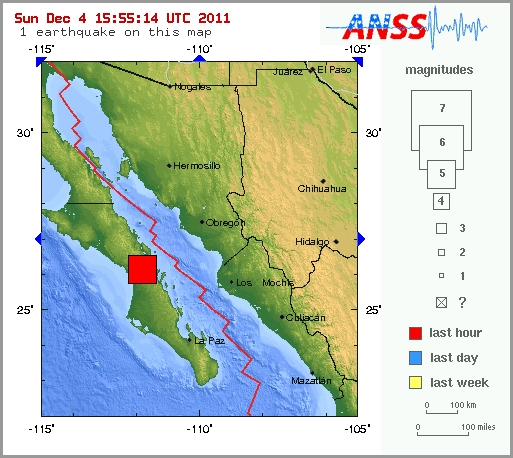
edit on 4-12-2011 by berkeleygal because: (no reason given)
Some further thoughts on Cook Strait 5.7
This quake popped up during a reasonably active period of background siesmicity, unlike the normal situation where the background siesmicity drops away to less than 4 quakes across the whole country for a day or two then kaboom a Mag 5+.
I may do a graph showing that, I've never thought numbers of quakes was relevant to anything, especially when the data is just preliminary and ends up getting x 2'd when the updates come in a month or so later, but the numbers have in the past shown this trend to be true for New Zealand.
The number and size of aftershocks has been quite low, so far only 4
MAG, REF, LAT, LONG, UTC, DEPTH
5.657, 3620927, -41.36401, 174.31493, 2011/12/3 6:19:10, 56
2.565, 3620929, -41.34479, 174.32152, 2011/12/3 6:27:41, 52
2.598, 3620992, -41.31139, 174.30701, 2011/12/3 9:20:35, 64
1.972, 3621183, -41.35921, 174.19737, 2011/12/3 9:40:12, 34
2.411, 3621087, -41.36708, 174.33586, 2011/12/3 14:23:43, 53
map of those
although if you zoom out to 10mi/20km scale on that map you will see there have been a few more quakes at 40-50km from the 5.7 too. Those 2 on the North Island side are close to the Wairarapa Fault which was the scene of the Mag 8.2 in 1855
I did this historic siesmicity Mag 5+ map back in 2009 for my Cook Strait special page which then became irrelevant when I started doing interactive maps of the whole country. Its an active area , we are used to earthquakes around here, its just part of life.
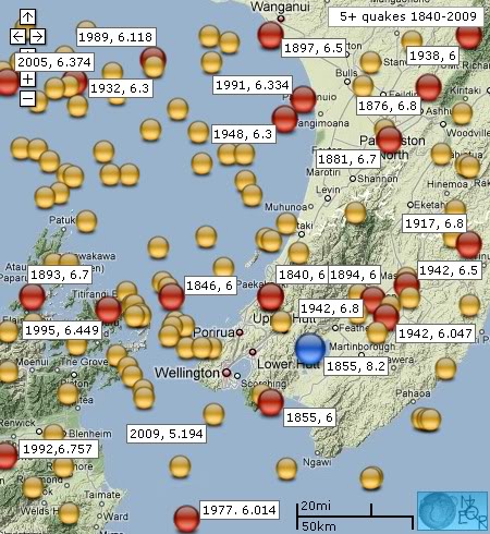
FWIW this 5.7 was on the Wairau Fault which runs up from the Wairau Valley through the Cook Strait and up the western North Island coast and splits around Kapiti Island just offshore where I live, at that point its only 2km away from my house
map of cook strait faults
In perspective we were more shook up by the 9 wicket loss to Australia at the Gabba, Brisbane test match ..... what a shocker :@@
This quake popped up during a reasonably active period of background siesmicity, unlike the normal situation where the background siesmicity drops away to less than 4 quakes across the whole country for a day or two then kaboom a Mag 5+.
I may do a graph showing that, I've never thought numbers of quakes was relevant to anything, especially when the data is just preliminary and ends up getting x 2'd when the updates come in a month or so later, but the numbers have in the past shown this trend to be true for New Zealand.
The number and size of aftershocks has been quite low, so far only 4
MAG, REF, LAT, LONG, UTC, DEPTH
5.657, 3620927, -41.36401, 174.31493, 2011/12/3 6:19:10, 56
2.565, 3620929, -41.34479, 174.32152, 2011/12/3 6:27:41, 52
2.598, 3620992, -41.31139, 174.30701, 2011/12/3 9:20:35, 64
1.972, 3621183, -41.35921, 174.19737, 2011/12/3 9:40:12, 34
2.411, 3621087, -41.36708, 174.33586, 2011/12/3 14:23:43, 53
map of those
although if you zoom out to 10mi/20km scale on that map you will see there have been a few more quakes at 40-50km from the 5.7 too. Those 2 on the North Island side are close to the Wairarapa Fault which was the scene of the Mag 8.2 in 1855
I did this historic siesmicity Mag 5+ map back in 2009 for my Cook Strait special page which then became irrelevant when I started doing interactive maps of the whole country. Its an active area , we are used to earthquakes around here, its just part of life.

FWIW this 5.7 was on the Wairau Fault which runs up from the Wairau Valley through the Cook Strait and up the western North Island coast and splits around Kapiti Island just offshore where I live, at that point its only 2km away from my house
map of cook strait faults
In perspective we were more shook up by the 9 wicket loss to Australia at the Gabba, Brisbane test match ..... what a shocker :@@
edit on
4-12-2011 by muzzy because: to add links
a foreshock,
a foreshock?
main shock?-------------------------------------------------------
source(www.emsc-csem.org...
TextMagnitude M 4.7 Region PAPUA, INDONESIA Date time 2011-12-04 18:40:24.0 UTC Location 5.45 S ; 140.22 E Depth 41 km Distances 328 km S Jaya pura (pop 134,895 ; local time 03:40:24.6 2011-12-05) 141 km NW Kiunga (pop 11,536 ; local time 04:40:24.6 2011-12-05)
a foreshock?
source(www.emsc-csem.org...
TextMagnitude mb 5.4 Region PAPUA, INDONESIA Date time 2011-12-04 18:53:04.0 UTC Location 5.33 S ; 140.34 E Depth 40 km Distances 313 km S Jaya pura (pop 134,895 ; local time 03:53:04.3 2011-12-05) 138 km NW Kiunga (pop 11,536 ; local time 04:53:04.3 2011-12-05)
main shock?-------------------------------------------------------
reply to post by diamondsmith
........................ Magnitude M 5.2
Region EASTERN NEW GUINEA REG., P.N.G.
Date time 2011-12-05 00:14:06.0 UTC
Location 6.23 S ; 146.57 E
Depth 85 km
Distances 368 km NW Port moresby (pop 283,733 ; local time 10:14:06.1 2011-12-05)
72 km NW Lae (pop 76,255 ; local time 10:14:06.1 2011-12-05)
www.emsc-csem.org...
edit on 4-12-2011 by muzzy because: (no reason given)
24 Hours.
What up, Earth?
What up, Earth?
4.7 2011/12/04 06:04:17 -8.173 117.521 186.2 SUMBAWA REGION, INDONESIA
4.7 2011/12/04 09:46:19 -37.827 -179.677 33.1 EAST OF THE NORTH ISLAND, NEW ZEALAND
4.8 2011/12/04 10:13:04 24.659 122.111 70.6 TAIWAN REGION
4.9 2011/12/04 10:44:36 19.905 -45.777 9.9 NORTHERN MID-ATLANTIC RIDGE
5.2 2011/12/04 10:23:54 19.815 -45.734 10.0 NORTHERN MID-ATLANTIC RIDGE
5.2 2011/12/04 15:55:29 56.248 163.202 25.9 NEAR EAST COAST OF KAMCHATKA, RUSSIA
5.2 2011/12/04 15:35:38 25.991 -111.813 10.0 BAJA CALIFORNIA SUR, MEXICO
5.1 2011/12/04 14:45:38 -31.493 -178.791 99.2 KERMADEC ISLANDS REGION
4.9 2011/12/04 18:09:47 1.471 95.275 35.1 OFF WEST COAST OF NORTHERN SUMATRA
4.6 2011/12/04 18:40:25 -5.450 140.220 40.9 PAPUA, INDONESIA
5.4 2011/12/04 18:53:03 -5.449 140.295 41.6 PAPUA, INDONESIA
4.7 2011/12/04 22:15:06 38.413 43.331 14.7 EASTERN TURKEY
5.2 2011/12/04 21:45:27 -3.968 127.713 181.6 SERAM, INDONESIA
4.7 2011/12/04 22:49:27 -34.233 -73.480 17.6 OFF COAST OF LIBERTADOR, CHILE
5.2 2011/12/05 01:01:12 36.169 141.758 10.3 NEAR THE EAST COAST OF HONSHU, JAPAN
5.2 2011/12/05 00:14:06 -6.234 146.571 85.4 EASTERN NGR, PAPUA NEW GUINEA
new topics
-
Don't cry do Cryo instead
General Chit Chat: 3 hours ago -
Tariffs all around, Except for ...
Predictions & Prophecies: 5 hours ago -
Gen Flynn's Sister and her cohort blow the whistle on DHS/CBP involvement in child trafficking.
Whistle Blowers and Leaked Documents: 10 hours ago
top topics
-
Trump sues media outlets -- 10 Billion Dollar lawsuit
US Political Madness: 16 hours ago, 25 flags -
Bucks County commissioners vote to count illegal ballots in Pennsylvania recount
2024 Elections: 15 hours ago, 22 flags -
Fired fema employee speaks.
US Political Madness: 17 hours ago, 10 flags -
Gen Flynn's Sister and her cohort blow the whistle on DHS/CBP involvement in child trafficking.
Whistle Blowers and Leaked Documents: 10 hours ago, 8 flags -
Don't cry do Cryo instead
General Chit Chat: 3 hours ago, 4 flags -
Anybody else using Pomodoro time management technique?
General Chit Chat: 13 hours ago, 3 flags -
Tariffs all around, Except for ...
Predictions & Prophecies: 5 hours ago, 3 flags
active topics
-
How can you defend yourself when the police will not tell you what you did?
Posse Comitatus • 84 • : bastion -
Tariffs all around, Except for ...
Predictions & Prophecies • 10 • : network dude -
Oligarchy It Is Then
Short Stories • 14 • : UKTruth -
Don't cry do Cryo instead
General Chit Chat • 1 • : angelchemuel -
Mike Tyson returns 11-15-24
World Sports • 54 • : angelchemuel -
President-Elect DONALD TRUMP's 2nd-Term Administration Takes Shape.
Political Ideology • 205 • : WeMustCare -
On Nov. 5th 2024 - AMERICANS Prevented the Complete Destruction of America from Within.
2024 Elections • 155 • : WeMustCare -
The Trump effect 6 days after 2024 election
2024 Elections • 143 • : cherokeetroy -
Bucks County commissioners vote to count illegal ballots in Pennsylvania recount
2024 Elections • 21 • : Irishhaf -
60s-70s Psychedelia
Music • 54 • : gort69
