It looks like you're using an Ad Blocker.
Please white-list or disable AboveTopSecret.com in your ad-blocking tool.
Thank you.
Some features of ATS will be disabled while you continue to use an ad-blocker.
WAITING FOR THE BIG ONE: A connection between Deepwater, Earthquakes, and other Deep-Well Drilling?
page: 1share:
Interactive Link.
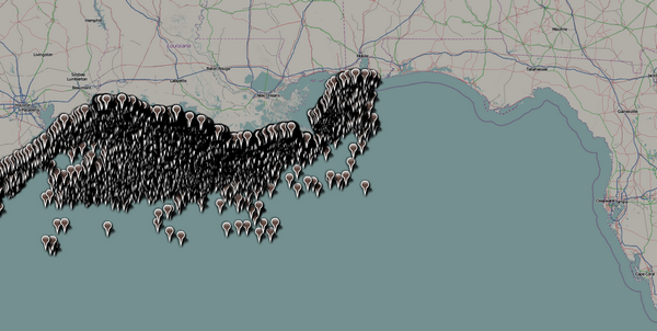
Take a good look at that map and consider the rest of the information presented in this thread.
I've been thinking a lot lately about a thread from Soficrow, written several years ago:
Mining Caused Major Earthquake
Mining significantly changed the stress field in the earth's upper crust, reactivated a major fault beneath Newcastle's coalfields, and triggered an earthquake that killed 13 people in 1989 causing billions of dollars in damage, say researchers. The effect is called "geomechanical pollution," and can be created by coal mining, constructing dams and reservoirs, and drilling for oil and gas.
Upon further research, I encountered material from Jack M. Reed, a retired Texaco geologist-geophysicist:
The New Madrid seismic zone in Missouri has long intrigued scientists because, according to conventional geologic theory, large earthquakes clustered in a tectonically quiet region are difficult to understand.
But at least one AAPG member is challenging the crowd.
New Orleans independent geologist Jack M. Reed believes the origin of the earthquakes lies beneath the Gulf of Mexico.
That's not all.
Reed, a retired Texaco geologist-geophysicist who has been studying the region's geology for over 40 years, says the accepted theory of a quiet geologic evolution of the Gulf of Mexico Basin is fundamentally flawed and needs to be revised.
According to him, the Gulf was and is tectonically active -- and it is the likely origin for not only the New Madrid seismic activity, but also for the Middleton Place-Summerville seismic zone near Charleston, S.C.
"For all the years I have worked the Gulf of Mexico Basin I have been forced to accept the 'passive' Gulf formation theory, which holds that the only movement in the basin is updip sedimentary loading that moved the salt southward," Reed said. "But there is little evidence to support this theory, and it doesn't fit what is observed geologically or geophysically.
"As Hugh Wilson said (1993), 'It would be geologically unusual for such a large basin as the Gulf of Mexico to remain almost tectonically undisturbed for 170 million years while major orogenic disturbances repeatedly struck bordering areas.'"
Reed, over the years, has gathered evidence that supports plate motion in the Gulf basin. Thick salt and sedimentary sequences in the basin mask this tectonic motion, but there is enough basin and peripheral evidence to show plate readjustment is occurring -- evidence, he says, in the form of volcanics, earthquakes and rift zones that are accompanied by magnetic, refraction, seismic and gravity data.
Gulf's Evolution Makes the Shakes
See where this thread is going?
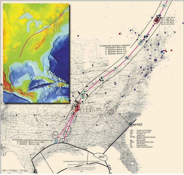
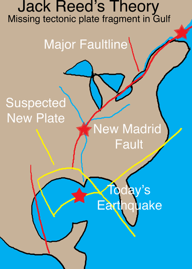
Here's a simplified version of the map above:
Link.
The article on Jack Reed's theory continues:
One piece of this evidence, according to Reed, is the apparent connection of the New Madrid seismic zone with the Gulf rift features to the south.
"This northeast trending earthquake zone appears to connect with the northeast trending Monroe Uplift, the LaSalle Arch and, possibly, to an active seismic zone located in and around Sabine Lake on the Texas-Louisiana border," he said.
This complex of doming and seismic centers is similar to another Cretaceous age triple juncture located in the northeastern Gulf of Mexico Basin. Doming of the DeSoto Canyon High during the Jurassic to Cretaceous created this triple juncture, which includes the Cretaceous Shelf Edge, the Suwannee Strait and the West Florida Escarpment.
If the New Madrid seismic zone is indeed part of a triple juncture, he continued, there should be an expression of this limb trending along a line in a northeast direction.
So Reed conducted a study using data from the U.S. Geological Survey's National Earthquake Information Center and the USGS map "Earthquakes in the Conterminous United States." He only studied earthquakes measuring at least magnitude 5, and found that while most of the earthquake centers are random with no alignment, there is a well-defined earthquake trend extending northeastward from the New Madrid seismic zone across the United States to Canada, where it joins with the St. Lawrence River seismic zone.
Within the boundaries of this earthquake alignment there are:
* Sixty-one seismic points that have a magnitude of 5 and greater.
* Several large earthquakes dating to the early 1800s, all measuring over magnitude 8, all occurring within a couple of months of each other, all centered in a northeast trending line.
* The two 5+ earthquakes that occurred earlier this year in northern New York state and southern Indiana.
"There is definitely some form of movement occurring along this trend," Reed said, "and it appears to be active today."
As he continued that trend south of New Madrid he found that it was in line with the Monroe Uplift.
"Suddenly I could see that this area had doming much like I had seen at the Desoto Canyon in the Gulf," he said. "This entire zone through the United States is suffering some type of tectonic activity that I believe is tied to the deeply buried tectonics in the Gulf of Mexico."
This theory from Jack Reed was published in November 2002. Then in 2006, it looked like there was ample evidence to support his claims:
Earthquakes in the Gulf of Mexico
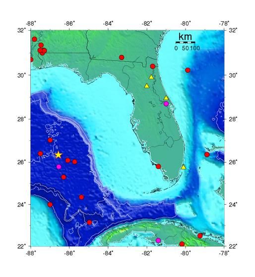
Although the rate of seismicity in the Gulf of Mexico is relatively low, the Gulf of Mexico is not seismically quiescent. Since the late 1800's there have been about 10 earthquakes large enough to be located which occurred in the eastern Gulf of Mexico. These earthquakes are mostly small magnitude events (magnitudes 3-4) but so far in 2006, two events with magnitudes in the 5.2 and 6.0 have occurred. All of the seisms occurred at very shallow depths beneath the Earth's surface in the deep water of the Gulf west of the Florida Escarpment. The small magnitudes of these events are consistent with the absence of tsunamis in the recent historical record of the Gulf coast states, although even earthquakes with modest magnitudes (6.0) can produce a tsunami if they occur in the vicinity of unstable sediments deposited on a sloping surface.
See also: Rare Earthquake Shakes Gulf of Mexico
And: Quakes trigger Quakes
So we have now two possibilities:
1) Oil drilling may contribute to increased risk of seismic activity in the Gulf of Mexico and beyond (read the big one-- New Madrid), or
2) Seismic activity in the Gulf of Mexico places additional oil wells at risk. (Imagine several Deepwater incidents all at once. )
So do you feel like we truly understand the sum total of the risk we really face?
Food for thought, huh?
Sweet dreams...
[edit on 12-5-2010 by loam]
This thread is amazing. Very well researched and presented, S&F for your godlike wisdom!
S & F
As you very clearly illustrated, there has long been a suspected connection between several man-made devices/activities and quakes. I personallyt suspect geothermal dwelling added to the last 'big' one in Chile.
As soon as I heard about the Gulf disaster, I had the same thought. Drilling at those depths, taping into something so massive below the ocean floor and now rapidly displacing all that pressure....it HAS to do something.
For me, it isn't so much 'IF' but 'WHAT'. Thank you for the maps and info, although it now causes me more concern. I didn't know there were faults there or a conncection to New Madrid. Oh man......
1) Oil drilling may contribute to increased risk of seismic activity in the Gulf of Mexico and beyond (read the big one-- New Madrid), or
2) Seismic activity in the Gulf of Mexico places additional oil wells at risk.
Either or shouldn't TPTB just up and STOP offshore drilling?
(Number 1 gets my vote by the way)...
Fantastic thread...
peace
[edit on 12-5-2010 by silo13]
Pretty scary stuff, huh?
One of the things I keep reading from a number of sources is that (other than Reed's theory) no one seems to have a really good explanation for any of the seismic activity in the Gulf of Mexico.
Maybe the connection to deep well drilling is MUCH MORE significant than anyone appreciates.
I really think there is something to this, imo.
[edit on 12-5-2010 by loam]
I'm bumping this up as I am thinking that it just got lost, because certainly more than a couple of us have something to say about it?
I think the implications here are huge.
I think the implications here are huge.
*sigh*
I guess drilling is going to be this year's Bush...EVERYTHING is gonna be drilling's fault...
[atsimg]http://files.abovetopsecret.com/images/member/e4d520a313f6.jpg[/atsimg]
I guess drilling is going to be this year's Bush...EVERYTHING is gonna be drilling's fault...
[atsimg]http://files.abovetopsecret.com/images/member/e4d520a313f6.jpg[/atsimg]
reply to post by loam
Well researched thread Loam! It is very interesting the implications of this offshore drilling in relation to seismic events. I can remember in 2000 that we had a tremor in Upstate New York which was around 3.9 on the Richter Scale. I was in summer marching band at the time and we all felt it. It lasted roughly 15-20 minutes. It was my first experience with any sort of seismic event, and I was rather shocked to find out that Upstate New York lies on a rather large fault line, like is highlighted in your diagram.
Very interesting. S&F for excellent content.
Peace be with you.
-truthseeker
According to him, the Gulf was and is tectonically active -- and it is the likely origin for not only the New Madrid seismic activity, but also for the Middleton Place-Summerville seismic zone near Charleston, S.C.
Well, well, well. I just looked at my Google Earth and interestingly, there are four EQs from 1 - 3 magnitude all lined up in a pretty little line on the New Madrid. AND, a 2.8 outside of Charleston on the Middleton Place-Summerville fault line, both referenced by Dr. Reed as the result of whatever is in the Gulf. All occurring this week.
By the way, did you know that there are 5 nuclear reactors within 50 miles or less of the Middleton Place-Summerville fault line??
[edit on 16/5/2010 by Iamonlyhuman]
Originally posted by loam
2) Seismic activity in the Gulf of Mexico places additional oil wells at risk. (Imagine several Deepwater incidents all at once. )
Um, since the Russians used to close oil and gas leaks using nuclear bombs shouldnt it be safe to say that hairlike oil well pipes would be closed off in such an event?
We're talking nanotube in scale here.
Oil well bore diameters fall between 5"-36".
Surface area of the Gulf of Mexico is 615,000 mi² (1.6 million km²), with 642 trillion gallons of water pushing down on the seafloor. Water weighs 8.3 pounds, meaning 5.328 quadrillion lbs. of pressure pushing down, no?
Do you really believe that since there are some 4,000 oil wells in the Gulf that the entire thing is going to cave in and erupt oil like Mt. St. Helens?
Lets say there are 4,000 wells, at the maximum size of 36" bores. That's 144,000 inches, or a 12,000' hole (total). That is remarkable! However, that's a drop in the pond considering that 2 mile wide hole is spread out thinly over an area of 615,000 mi².
Therefore, this image is deceptive:
The size of those points create a context where the entire surface is drilled out and waiting to cave in. In reality, if all of those points were the maximum 36" bore size the dots wouldn't even appear on the map. Lets keep it real here.
[edit on 16-5-2010 by IgnoranceIsntBlisss]
This is troubling news.
Does anyone know what type of fault line (slip\convergent)
Does anyone know what type of fault line (slip\convergent)
reply to post by Just Wondering
Great seeing you again. You add so much to these threads, would like to see your avatar and words of wisdom on every billboard along the lovely Interstate 10 as it crosses the glorious state of Texas because you remind of of that somehow. Oh, and Bush Jr. Yeah him too.
Great seeing you again. You add so much to these threads, would like to see your avatar and words of wisdom on every billboard along the lovely Interstate 10 as it crosses the glorious state of Texas because you remind of of that somehow. Oh, and Bush Jr. Yeah him too.
Thanks for giving us another reason to think that the end of the world is just around the corner. Seriously, that was great work. It almost seems like
it WAS done on purpose, just another part of the evil plan...
reply to post by warpcrafter
Right. Thanks for scaring the crap out of us! Good job!
Like the elitist tyrants who seek to become immortal are really trying to deliberately ensure absolute total destruction of the environment.
Right. Thanks for scaring the crap out of us! Good job!
Like the elitist tyrants who seek to become immortal are really trying to deliberately ensure absolute total destruction of the environment.
I think Oil and Gas drilling definatley has some effect on Seismic activity. Interesting article about when these effect were first noticed in the
1930's -
and I feel this is a very important quote below from the site -
Interesting stuff. So we have to wonder in this case, "Whats being put back in to this well to replace the oil thats coming out? . At the moment, nothing. This does not sound good at all.
esd.lbl.gov...&gas/
Water Injection Method
Onshore example (similar process for offshore drilling)
[atsimg]http://files.abovetopsecret.com/images/member/46ed25b8ff22.gif[/atsimg]
Details of Water Injection Methods
So there you have it. It's well documented about the effects of Pressure through removal of oil, and not replacing the pressure in the well.
I wonder what the effects could be of this?
G.
Induced seismicity in oil and gas production has been observed ever since the 1930s, i.e., ever since large scale extraction of fluids occurred. The most famous early instance was in Wilmington, California, where the oil production triggered a series of damaging earthquakes
and I feel this is a very important quote below from the site -
In this instance the cause of the seismicity was traced to subsidence due to rapid extraction of oil without replacement of fluids. Once this was realized the oil extraction was balanced with water injection to mitigate the seismicity
Interesting stuff. So we have to wonder in this case, "Whats being put back in to this well to replace the oil thats coming out? . At the moment, nothing. This does not sound good at all.
esd.lbl.gov...&gas/
Water Injection Method
Used in onshore and offshore developments, water injection involves drilling injection wells into a reservoir and introducing water into that reservoir to encourage oil production. While the injected water helps to increase depleted pressure within the reservoir, it also helps to move the oil in place
Onshore example (similar process for offshore drilling)
[atsimg]http://files.abovetopsecret.com/images/member/46ed25b8ff22.gif[/atsimg]
Details of Water Injection Methods
So there you have it. It's well documented about the effects of Pressure through removal of oil, and not replacing the pressure in the well.
I wonder what the effects could be of this?
G.
Well, it looks like pretty much all of this oil related doomongering has been debunked:
www.abovetopsecret.com...
www.abovetopsecret.com...
reply to post by IgnoranceIsntBlisss
Who is this question for?
I never said this and I can't see where anyone else has in this thread has either.
[edit on 16-5-2010 by loam]
Originally posted by IgnoranceIsntBlisss
Do you really believe that since there are some 4,000 oil wells in the Gulf that the entire thing is going to cave in and erupt oil like Mt. St. Helens?
Who is this question for?
I never said this and I can't see where anyone else has in this thread has either.
[edit on 16-5-2010 by loam]
reply to post by IgnoranceIsntBlisss
You're debunking an argument not presented in this thread.
[edit on 16-5-2010 by loam]
Originally posted by IgnoranceIsntBlisss
Well, it looks like pretty much all of this oil related doomongering has been debunked:
www.abovetopsecret.com...
You're debunking an argument not presented in this thread.
[edit on 16-5-2010 by loam]
reply to post by IgnoranceIsntBlisss
I think you misunderstood the point of the image.
It was to point out the number of wells where presumably similar blow-out risks as Deepwater exist...or the quantity of which could contribute to seismic activity with significant impact.
It's odd how you're off 'debunking' a level of hysteria not found in this thread.
Actually, it's bizarre.
[edit on 16-5-2010 by loam]
Originally posted by IgnoranceIsntBlisss
Therefore, this image is deceptive:
I think you misunderstood the point of the image.
It was to point out the number of wells where presumably similar blow-out risks as Deepwater exist...or the quantity of which could contribute to seismic activity with significant impact.
It's odd how you're off 'debunking' a level of hysteria not found in this thread.
Actually, it's bizarre.
[edit on 16-5-2010 by loam]
reply to post by loam
Following your link:
Following your logic:
'All of the oil wells, and rapid drain situations such as the current blowout will trigger earthquakes, which rupture more oil wells, which triggers more quakes, which triggers more ruptures, which causes massive cave-ins in the empty undersea oil chambers, which...'
And don't act like your source didn't use that map to amplify the emotional response.
[edit on 16-5-2010 by IgnoranceIsntBlisss]
Following your link:
Quakes trigger Quakes Quakes trigger quakes
Following your logic:
'All of the oil wells, and rapid drain situations such as the current blowout will trigger earthquakes, which rupture more oil wells, which triggers more quakes, which triggers more ruptures, which causes massive cave-ins in the empty undersea oil chambers, which...'
And don't act like your source didn't use that map to amplify the emotional response.
[edit on 16-5-2010 by IgnoranceIsntBlisss]
new topics
-
Joe Rogan and The Black Keys Diorama
General Entertainment: 14 minutes ago
top topics
-
Plane Crash in South Korea
Mainstream News: 14 hours ago, 11 flags -
Cutting Boards
Food and Cooking: 17 hours ago, 10 flags -
Joe Rogan and The Black Keys Diorama
General Entertainment: 14 minutes ago, 0 flags
active topics
-
Kurakhove officially falls. Russia takes control of major logistics hub city in the southeast.
World War Three • 27 • : Imhere -
Plane Crash Today --Azerbaijanian E190 passenger jet
Mainstream News • 71 • : Oldcarpy2 -
Why Such An Uproar Over Non-US Citizens With H1-B Work Visas.
Social Issues and Civil Unrest • 57 • : Springbok -
Joe Rogan and The Black Keys Diorama
General Entertainment • 0 • : GENERAL EYES -
Evidence of Covid-19 Vaccine Dangers -and- Possible Covid-19 Vaccine Induced Deaths.
Diseases and Pandemics • 175 • : Oldcarpy2 -
-@TH3WH17ERABB17- -Q- ---TIME TO SHOW THE WORLD--- -Part- --44--
Dissecting Disinformation • 3841 • : Thoughtful3 -
Plane Crash in South Korea
Mainstream News • 17 • : WeMustCare -
Mexico Plans Alert App For Migrants Facing Arrest In US
Mainstream News • 10 • : WeMustCare -
New York Governor signs Climate Law that Fines Fossil Fuel Companies
US Political Madness • 35 • : Irishhaf -
Cutting Boards
Food and Cooking • 8 • : butcherguy


