It looks like you're using an Ad Blocker.
Please white-list or disable AboveTopSecret.com in your ad-blocking tool.
Thank you.
Some features of ATS will be disabled while you continue to use an ad-blocker.

Question to opponents of CIT
page: 2share:
reply to post by tezzajw
Try to keep up Tezz and re-read the previous posts.
THEN tell me if his drawing is NOC.
Thank you
Try to keep up Tezz and re-read the previous posts.
THEN tell me if his drawing is NOC.
Thank you
reply to post by CameronFox
See that's the tough part, Cameron. Maybe you'll be able to keep up here and follow this?
The CITGO can't be seen in that picture/drawing. The drawing is a skewed 3-D perspective, which isn't clear about altitude or heading.
From that drawing it's hard to determine if the flight path was NOC or SOC. However, it's clear that it certainly passes ONA.
An overhead 2-D plan view, would show a more accurate flight path, don't you think?
Originally posted by tezzajw
An overhead 2-D plan view, would show a more accurate flight path, don't you think?
Considering Paik's POV, I think this drawing would be more appropriate. No?
Originally posted by CameronFox
Considering Paik's POV, I think this drawing would be more appropriate. No?
No, I'm fairly sure that Ed Paik wasn't on a Sheraton balcony (or in a helicopter hovering over the area). I'd like to see several different photos/diagrams of the area. Is no one else familiar with the concepts of "timeslices" (or "frames" from high speed photography) and "windows of opportunity?"
I know that 3D modeling and CAD software will often give at least 6 views (but the bottom view would be a little silly IMHO, and I'm partial to "north up").
Can someone please quote a specific "the flight path" that CIT has provided or endorsed for clarity's sake? I must have missed it somewhere along the way.
Thanks in advance,
RH
Originally posted by CameronFox
Considering Paik's POV, I think this drawing would be more appropriate. No?
No, I don't think that it is appropriate.
It's why some Year 12 students study vectors in 3-D space. There's lots of pitfalls trying to force a 3-D flight path onto a skewed 2-D image.
Paik put the plane ONA. If true, that destroys the official story.
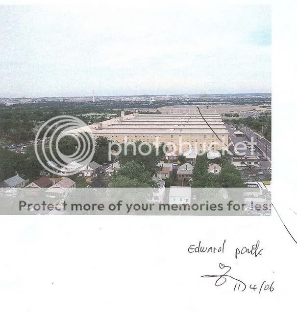
The Edward Paik illustration in question is 100% north of Columbia Pike, over the Navy Annex, and north of the citgo.
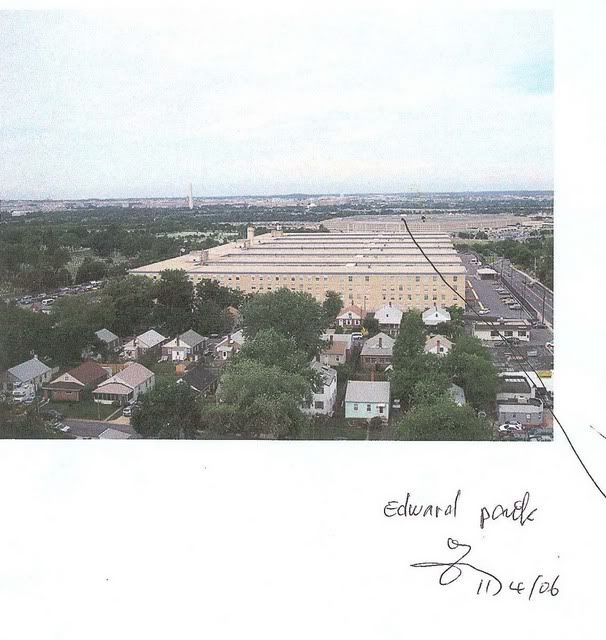
Clearly it's a much different perspective than this other Ed Paik drawing:
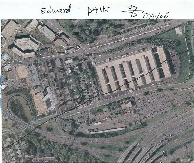
But he STILL illustrated the exact same north side flight path on both images even though they are taken from completely different perspectives.
The citgo is not at the foot of the Navy Annex.
If you continue the same ANGLE/trajectory illustrated by Ed in both images throughout the entire DISTANCE between the Navy Annex and Citgo you will see it ends up NoC as Ed illustrated above.

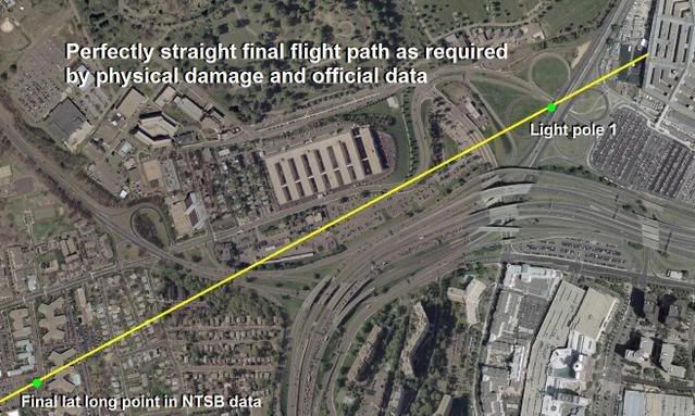
But the important point here and the indisputable FACT is that the plane has to be south of Columbia Pike at all times yet Edward draws it crossing to the north side of Columbia Pike on ALL THREE images.

100% North side approach. Corroborated to the point of redundancy.
Clearly NOT the south side path as required by all official reports, data, and the physical damage as illustrate below.
Clearly it's a much different perspective than this other Ed Paik drawing:
But he STILL illustrated the exact same north side flight path on both images even though they are taken from completely different perspectives.
The citgo is not at the foot of the Navy Annex.
If you continue the same ANGLE/trajectory illustrated by Ed in both images throughout the entire DISTANCE between the Navy Annex and Citgo you will see it ends up NoC as Ed illustrated above.
But the important point here and the indisputable FACT is that the plane has to be south of Columbia Pike at all times yet Edward draws it crossing to the north side of Columbia Pike on ALL THREE images.
100% North side approach. Corroborated to the point of redundancy.
Clearly NOT the south side path as required by all official reports, data, and the physical damage as illustrate below.
Originally posted by rhunter
Can someone please quote a specific "the flight path" that CIT has provided or endorsed for clarity's sake? I must have missed it somewhere along the way.
Thanks in advance,
RH
We don't endorse an exact flight path.
We simply report what the witnesses tell us.
The below image is a compilation composite of all witness flight path drawings we have obtained.
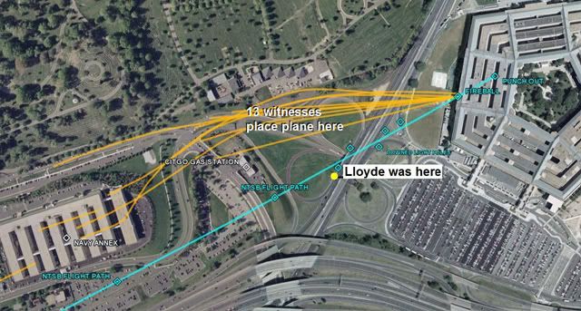
So the above image represents the extent of what we "endorse" yet we acknowledge that all witnesses are prone to error and subject to limitations due to perspective.
What's clear is that all first-hand accounts available in the public domain unanimously place the plane, north of Columbia Pike, directly over the Navy Annex, and north of the citgo.
This is what proves 9/11 was an inside job.
Originally posted by CameronFox
here ya go RH:
Hey thanks Cameron. You know that looks to be the same image posted here on CIT's website on Dec. 6, 2007:
Powerhouse's claims about Edward Paik, and his flight path
Edward Paik drawings
First off, just because I do not believe in the flyover theory does not mean I do not believe there was government involvement. Your question assumes
just because we doubt the CIT version of events means we accept the official story in it's entierty. I do not, for one.
Second, CIT interviewed witnesses years AFTER the event. And only a handful compared to the hundreds of eyewitness accounts taken that day. Witness accounts are the most solid when taken very shortly after the event, when the event is still fresh in their minds. Time tends to distort memory.
Third, not all witnesses that were intyerviewed by the supported their version of events, and their interviewing tactics were very questionable.
And of course, the CITGO videos themselves show through shadow analysis that the plane flew south of citgo.
reply to post by Craig Ranke CIT
I keep seeing the same allegedly "original" .gif posted repeatedly on several threads here:
www.abovetopsecret.com...
www.abovetopsecret.com...
Although I don't see how any animated .gif can ever prove anything, the Ed Paik issue has been covered several times already here at ATS:
www.abovetopsecret.com...
www.abovetopsecret.com...
www.abovetopsecret.com...
www.abovetopsecret.com...
I wonder if there is any audio that accompanies those 2 animated .gifs... Oh wait, here it is:
www.youtube.com...
Edward Paik talks about the plane location at 02:50, 03:50, 04:04, 04:13, 04:22, 04:35, 04:52, 09:32 ("body side here [North], wing this way" [Columbia Pike] multiple times). Well that should clarify things for most people about the 2 silent .gif images (one of which has a caption).
See also at 02:10 of Part I here (and I believe there is more in Part II, but I had connection problems while watching Part II again and was unable to get a time index for that):
www.thepentacon.com...
The only problem I ever had with CIT was the issue of recording witnesses without their knowledge. I don't feel its ethical or legal, they do. In any
case there is certainly not sufficient evidence that flight 77 hit the pentagon and working all angles of that is important. Sitting on your padded
pleather computer chair disputing it from the internets is what most of us do and not the same level contribution, and so for that I commend CIT.
new topics
-
Thune selected as Senate Republican Leader
US Political Madness: 33 minutes ago -
Band of Brothers 2001 Classic
Television: 38 minutes ago -
US warship Edsall Lost after Pearl Harbor Attack Found 80 Years Later ... by Accident
Mainstream News: 1 hours ago -
WATCH LIVE: US Congress hearing on UFOs, unidentified anomalous phenomena
Aliens and UFOs: 3 hours ago -
Worlds Behind You…
Short Stories: 3 hours ago -
Con Man Don
Jokes, Puns, & Pranks: 3 hours ago -
How can you defend yourself when the police will not tell you what you did?
Posse Comitatus: 7 hours ago
top topics
-
Trump picks Gov. Kristi Noem to serve as homeland security secretary
2024 Elections: 16 hours ago, 14 flags -
How can you defend yourself when the police will not tell you what you did?
Posse Comitatus: 7 hours ago, 14 flags -
US warship Edsall Lost after Pearl Harbor Attack Found 80 Years Later ... by Accident
Mainstream News: 1 hours ago, 8 flags -
WATCH LIVE: US Congress hearing on UFOs, unidentified anomalous phenomena
Aliens and UFOs: 3 hours ago, 6 flags -
Worlds Behind You…
Short Stories: 3 hours ago, 4 flags -
Thune selected as Senate Republican Leader
US Political Madness: 33 minutes ago, 4 flags -
Band of Brothers 2001 Classic
Television: 38 minutes ago, 1 flags -
Con Man Don
Jokes, Puns, & Pranks: 3 hours ago, 0 flags
active topics
-
WATCH LIVE: US Congress hearing on UFOs, unidentified anomalous phenomena
Aliens and UFOs • 13 • : putnam6 -
The Trump effect 6 days after 2024 election
2024 Elections • 90 • : DBCowboy -
President-Elect DONALD TRUMP's 2nd-Term Administration Takes Shape.
Political Ideology • 143 • : burntheships -
US warship Edsall Lost after Pearl Harbor Attack Found 80 Years Later ... by Accident
Mainstream News • 7 • : KnowItAllKnowNothin -
Thune selected as Senate Republican Leader
US Political Madness • 3 • : putnam6 -
-@TH3WH17ERABB17- -Q- ---TIME TO SHOW THE WORLD--- -Part- --44--
Dissecting Disinformation • 3248 • : Thoughtful3 -
Band of Brothers 2001 Classic
Television • 1 • : PorkChop96 -
Tomorrow will be the 7th day after the election, and they are still counting
US Political Madness • 43 • : network dude -
Trump picks Gov. Kristi Noem to serve as homeland security secretary
2024 Elections • 20 • : burntheships -
Russia Ukraine Update Thread - part 3
World War Three • 6794 • : Oldcarpy2