It looks like you're using an Ad Blocker.
Please white-list or disable AboveTopSecret.com in your ad-blocking tool.
Thank you.
Some features of ATS will be disabled while you continue to use an ad-blocker.
share:
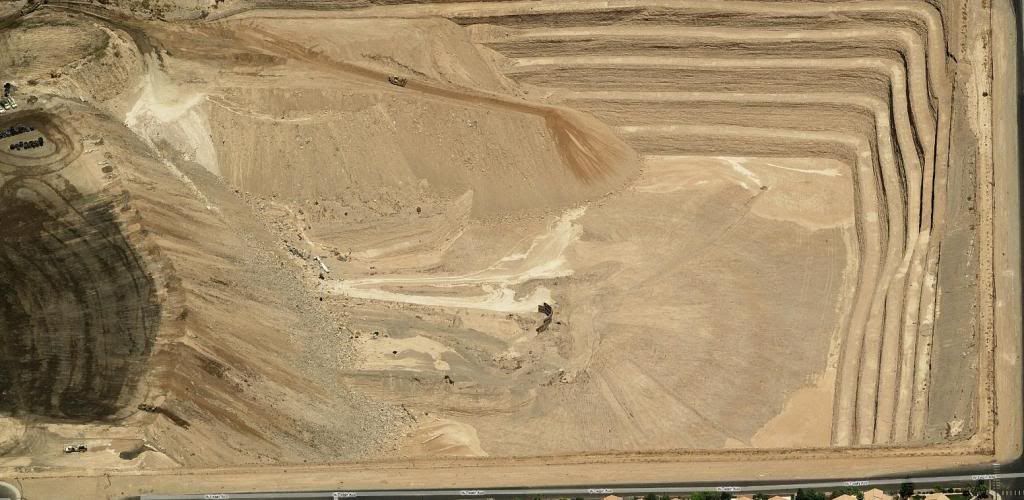
Here in Vegas, if you ask almost anyone on the West side if they know about the huge open pits in the area, they will most likely reply "yea, those
are just flood basins", and that would be the end of the conversation.
Now this would seem to be a perfectly legitamate explanation for there presence due to the annual heavy flooding that occurs in Vegas. Yet these enormous pits were more than deep enough to accomodate the flood waters almost 5 years ago! To this day, they are still digging deeper and deeper into the 2 major pits, and currently it is not possible to see the bottom of the largest without trespassing or using an aircraft!
I did some research into these pits and found that they are using the abbundance of gravel coming out as their reason for still digging. But these pits supposedly were designed as water traps, not pay dirt. A few months ago we had our heaviest rains of the year so far, and drove by these pits multiple times to see if they were anywere close to capacity, yet I saw no water in either of the 2 largest pits. So I am no longer convinced that these were ever really designed to be flood basins.
Due too the depth and scale of these pits, I'd presume they were mining some sort of precious material. But when I think of the area and the overall lack of any substancial mineral deposits, I come to the conlusion that they must be being used as cover for something larger. The conditions are ideal for this scenario, and due to the depths, I'm guessing it involves some sort of underground structure.
I'd love to hear some other possible theories, also heres the coordinates so you can see for yourself---> 36° 6'20.15"N, 115°16'37.88"W and 36° 7'26.38"N, 115°15'15.51"W
(Goole Earth's Images show the pits when they were much much smaller btw).
I am also going to be taking some photos of these pits as they are now in the next few days, and I will post them on here as soon as I have them.
Wow... utterly strange... do you have pictures for those of use who don't have GE?
Is it possible that they are digging for natural gas or helium? They do that here sometimes... dig a big pit... then use a portable derrick or sometimes no derrick at all.
Is it possible that they are digging for natural gas or helium? They do that here sometimes... dig a big pit... then use a portable derrick or sometimes no derrick at all.
I took a look at them. It seems very strange to me to have some sort of mining operation like that or something similar in the middle of a suburban
area. Perhaps looking for something "important"? Speculation on my part here.
I'd recommend seeing if you can manage to get in contact with the civil engineers who are actually working on the project. Maybe they are just
preparing for exceptionally large floods because they were scared into it by disasters like Katrina.
Is it possible that they started as drainage and once they found high quality gravel they decided to dig it up?
unable to get to that corr!! GE states .. "does not exit"
not sure what else to say than that
not sure what else to say than that
They are aggregate pits for 2 of the major concrete and asphalt companies in town, Rinker (also goes by Cemex), and Las Vegas Paving.
Go out around the 215 and Lone Mountain area, and you will see another aggregate pit, that one is owned by Nevada Ready Mix (another concrete company).
Go out around the 215 and Lone Mountain area, and you will see another aggregate pit, that one is owned by Nevada Ready Mix (another concrete company).
I used Virtual Earth and found some big holes, apparently right in the middle of a residential area of the West part of Las Vegas. Once you get close,
it has a "bird's eye" butten that gives you an arial photo (seperate from the normal map). This is what I got on one of these holes.
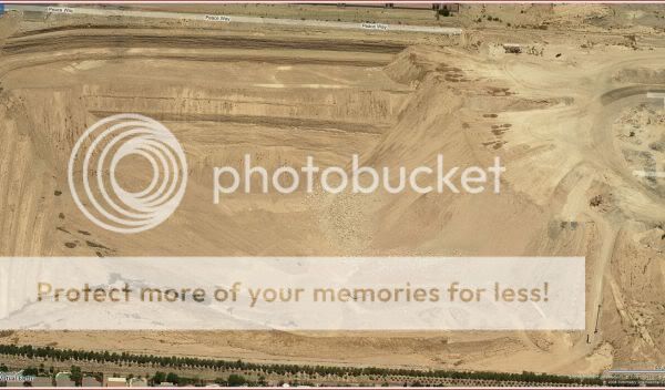
Here is a close up of the bottom.
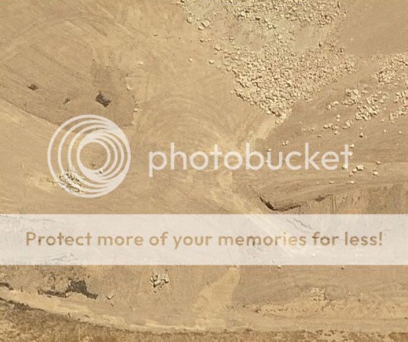
Here is this spot in the normal map view.
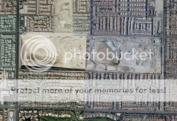
Here is what was going on in what would be the right hand half, in the map view.
[edit on 13-10-2008 by jmdewey60]

Here is a close up of the bottom.

Here is this spot in the normal map view.

Here is what was going on in what would be the right hand half, in the map view.

[edit on 13-10-2008 by jmdewey60]
reply to post by asmeone2
You can plug the coordinates into maps.google.com as well.
This is not a one line post. I need to create a profile here.
You can plug the coordinates into maps.google.com as well.
This is not a one line post. I need to create a profile here.
Is there any possibility that the gravel is being washed for gold? There was a gravel pit in my area where that was happening. There was only flour
gold here but it was assayed as being over 80% pure. As far as I know there is still gold to be found in California.
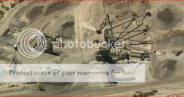
Want me to describe what is seen in that bottom photo?
Just normal aggregate pit operations.
Mixer, conveyors, kiln, haulers, and on and on.
Just normal aggregate pit operations.
Mixer, conveyors, kiln, haulers, and on and on.
Quarry operations in the middle of urban areas aren't really all that rare. I can think of at least three right off the top of my head- huge pits in
the McCook, IL area; one here in Oshkosh less than a mile from my house; and one just up the road in Neenah, WI. The ones here in Oshkosh and Neenah
started out in "the country" but the cities grew up around them.
Rumor has it the one here in Oshkosh will be shutting down in the next few years and be turned into a public park.
Rumor has it the one here in Oshkosh will be shutting down in the next few years and be turned into a public park.
Yep, like I said, they do have a gravel operation at the 2 smaller pits, but the bigger one thats by itself ( 36° 6'20.15"N, 115°16'37.88"W )
does not. Also, the birdseye views in virtual earth were taken quite a while ago, and from my most recent look at the big pit, it's getting a lot
deeper, and more narrow.
Also, I will see what I can do about getting in touch with the civil engineer in charge, but that doesn't mean I'd trust him to give me the real facts anyways, this is Las Vegas and its filled with corruption.
Also here's the coordinates again in a different format ( 36 6.20 n 115 16.37 w )
Also, I will see what I can do about getting in touch with the civil engineer in charge, but that doesn't mean I'd trust him to give me the real facts anyways, this is Las Vegas and its filled with corruption.
Also here's the coordinates again in a different format ( 36 6.20 n 115 16.37 w )
reply to post by my27questions
Well, if they are for flooding I've got two words for ya. New Orleans
The levees were supposed to hold but they didn't.
But I tend to think they're quarries of some kind. You can bet when they get done mining it, they'll fill it in and plant some nice trees, or make an artificial lake. I remember a quarry when I was a child that was right outside my town. I used to love going down there because the quarry tended to attract water. And we'd go down and wade in the water and fish for crawfish. The quarry people didn't seem to mind. We never got in the way. One day we went out there and there were a bunch of bulldozers filling in the quarry which made my creek go bye bye. I was pretty upset. To this day, they have done nothing with that land. If you saw it, you'd have a hard time believing a quarry once existed there.
Also, by the way, if you look about a half block north of the pit, you'll see an older pit that was dug out, then filled back in for some reason.
Originally posted by my27questions
Yep, like I said, they do have a gravel operation at the 2 smaller pits, but the bigger one thats by itself ( 36° 6'20.15"N, 115°16'37.88"W ) does not. Also, the birdseye views in virtual earth were taken quite a while ago, and from my most recent look at the big pit, it's getting a lot deeper, and more narrow.
Also, I will see what I can do about getting in touch with the civil engineer in charge, but that doesn't mean I'd trust him to give me the real facts anyways, this is Las Vegas and its filled with corruption.
Also here's the coordinates again in a different format ( 36 6.20 n 115 16.37 w )
Actually yes it does.
If you want proof, drive down Durango around 2 or 3 am and you will see the trucks (and the rocks they dump all over the road) exiting it. That one is about done though, they are now working on another pit on Blue Diamond and Jones.
[edit on 14-10-2008 by Constitutional Scholar]
Here is a birdseye of the big pit, you don't really get full effect of this pit unless you actually see a ground image. I will be cruising to each of
these pits tomorrow to snap some pics for you guys.

Your right Constitutional Scholar, I thought I was looking at a different pit, nice call.
The one on Spring Mt andRainbow, thats a big, deep mofo. Would be nice to fill them with water and stock it with fish when Cemex is done with them,
but that would require way more common sense than the County Commission has.
reply to post by my27questions
That looks like the same pit, just from the opposite side. Virtual Earth uses decimals of degrees instead of minutes and seconds, so I was not sure if I had the right one.
That looks like the same pit, just from the opposite side. Virtual Earth uses decimals of degrees instead of minutes and seconds, so I was not sure if I had the right one.
new topics
-
OK this is sad but very strange stuff
Paranormal Studies: 4 hours ago -
Islam And A Book Of Lies
Religion, Faith, And Theology: 5 hours ago -
Sorry to disappoint you but...
US Political Madness: 8 hours ago
top topics
-
Sorry to disappoint you but...
US Political Madness: 8 hours ago, 13 flags -
Watch as a 12 million years old Crab Emerges from a Rock
Ancient & Lost Civilizations: 12 hours ago, 10 flags -
OK this is sad but very strange stuff
Paranormal Studies: 4 hours ago, 6 flags -
Islam And A Book Of Lies
Religion, Faith, And Theology: 5 hours ago, 5 flags
active topics
-
Sorry to disappoint you but...
US Political Madness • 15 • : Flyingclaydisk -
Meta Llama local AI system is scary good
Science & Technology • 39 • : Arbitrageur -
ILLUMINATION: Dimensions / Degrees – Da Vincis Last Supper And The Philosophers Stone
Secret Societies • 5 • : Compendium -
Musk calls on King Charles III to dissolve Parliament over Oldham sex grooming gangs
Mainstream News • 180 • : Freeborn -
Islam And A Book Of Lies
Religion, Faith, And Theology • 3 • : nugget1 -
Outgoing Lame Duck BIDEN Officials and Democrats Voice Their Regrets.
2024 Elections • 30 • : WeMustCare -
Joe Biden gives the USA's Highest Civilian Honor Award to Hillary Clinton and George Soros.
US Political Madness • 46 • : WeMustCare -
Tesla Cybertruck Explodes in Front of Trump Hotel in Las Vegas
Mainstream News • 229 • : Daughter2v2 -
What Is 'Quad Demic'? Mask Mandate Returns In These US States
Diseases and Pandemics • 39 • : AdultMaleHumanUK -
OK this is sad but very strange stuff
Paranormal Studies • 2 • : Ravenwatcher
